Sean
Jun 4 2016, 11:58 AM
No, thank you man, very inspired by your work.
Here is a cheeky link for a work in progress image... ( Sol 3754 )

I will post in the relevant forum when it is finished.
Burmese
Jun 8 2016, 06:02 PM
Any close-ups yet from where Oppy trenched a bit with the wheel and exposed some new stuff (as mentioned in the latest Planetary Society article)?
fredk
Jun 8 2016, 07:13 PM
Lots of MI's. Atomoid posted a stereo version a dozen or so posts back.
atomoid
Jun 16 2016, 10:05 PM
Official releases of the Marathon Valley panorama are up on jpl
photojournal page
pano /
false /
anaglyph.
Midnight Planets has been stuck all week at
sol4401 (affecting MSL as well), not sure whats going on,
oh the pain of that separation anxiety and having to settle for cumbersome
nasa page
elakdawalla
Jun 16 2016, 10:07 PM
I talked with Mike and he will hopefully be able to fix the MP problem this weekend. It's hard for me too

jvandriel
Jun 21 2016, 12:46 PM
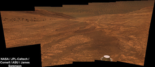
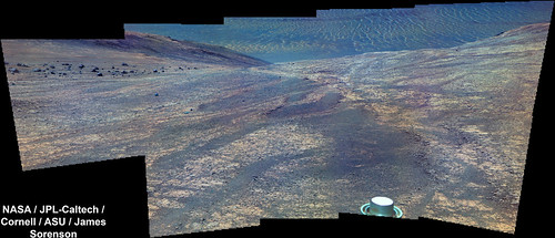
The Navcam L0 Panoramic view on Sol 4409.
Jan van Driel
Click to view attachment
Phil Stooke
Jun 21 2016, 08:42 PM
Thanks, Jan - here is a circular version to show the pattern of outcrops here.
Phil
Click to view attachment
James Sorenson
Jun 24 2016, 04:31 AM
Here is my version of the 4409 Navcam 360. I did this one mainly to tryout the new navcam flatfields that it took on Sol-4408.
Polar:
Normal:
elakdawalla
Jun 24 2016, 03:18 PM
Holy cow those flat fields are effective

fredk
Jun 26 2016, 03:04 PM
Looks like a long drive towards the northwest on 4415 - I think these are the 4081 drive tracks:
http://qt.exploratorium.edu/mars/opportuni...0M1.JPG?sol4415
atomoid
Jun 27 2016, 09:50 PM
right, it will interesting to see the current state of the tracks if that's part of the plan, and we never did manage to get a snapshot of that cleanly hewn tree
trunk on the way down, which is now the subject of a filter sweep. It seems no pics were taken sol4080, actually its hard to spot but at the right of center in this
sol4079 shot, almost exactly
a year ago..
[EDIT 6/29] since the MER team seems to be interested in repeated imaging of this feature, might as well throw in anaglyphs of
sol4416 stitch, anag of
sol4417 and cross of
sol4418 views here, fwiw..
Click to view attachment Click to view attachment Click to view attachment
James Sorenson
Jul 2 2016, 04:54 AM
jvandriel
Jul 5 2016, 03:19 PM
The Navcam L view on Sol 4418-4420.
Jan van Driel
Click to view attachment
Phil Stooke
Jul 5 2016, 05:13 PM
Thanks, Jan - this is a circular reprojection of it to show the pattern of outcrops.
Phil
Click to view attachment
jvandriel
Jul 6 2016, 06:40 PM
The Navcam L0 panoramic view on Sol 4423-4425.
Jan van Driel.
Click to view attachment
James Sorenson
Jul 7 2016, 05:52 AM
jvandriel
Jul 7 2016, 07:13 PM
The Navcam L view on Sol 4426.
Jan van Driel
Click to view attachment
Floyd
Jul 8 2016, 12:05 AM
QUOTE (Phil Stooke @ Oct 16 2015, 07:12 PM)

Another update - looks like I will need a new base map soon.
Phil
Click to view attachmentSo are we off to stations 3-6? I don't know why Phil's map doesn't display--but follow link to Phil's post.
Phil Stooke
Jul 9 2016, 02:38 PM
Hi - sorry, Floyd, what is it that is not working?
Phil
Floyd
Jul 9 2016, 04:47 PM
Hi Phil--your map displays just fine in your post. I quoted it and thought the map would show up in my post, but only get hypertext and no map. Guess I don't quite know how to repost images here.
My real question is if anyone knows if we are off to visit Stations 3-6 (which your map helpfully illustrated)
fredk
Jul 9 2016, 06:45 PM
All the recent updates give the impression that we're finishing up at Marathon and are on our way out. We may be heading back to this Mesa area just so that we can exit along our known entrance route. (Just a guess.)
Floyd
Jul 10 2016, 12:02 AM
That is what I thought, but then we seemed to be exploring the valley. Guess we will see.
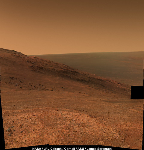
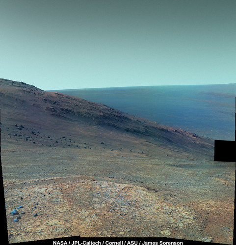
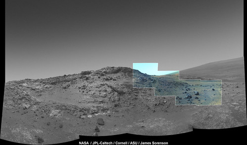
James Sorenson
Jul 10 2016, 12:28 PM
Swann Hill on Sol-4428. I'm working on the color mosaic that was taken of Jean-Baptiste La Jeunesse on 4429.

False Color:

James Sorenson
Jul 11 2016, 08:52 AM
Ipparchus
Jul 11 2016, 11:17 AM
QUOTE (fredk @ Jul 9 2016, 09:45 PM)
All the recent updates give the impression that we're finishing up at Marathon and are on our way out. We may be heading back to this Mesa area just so that we can exit along our known entrance route. (Just a guess.)
A.J.S. Rayl has posted her monthly @MarsRovers update for June 2016 (Sols 4393-4421)
http://www.planetary.org/explore/space-top...hon-valley.htmlwhy they don`t mention anything about Iazu Crater? I thought that was our

next destination...
James Sorenson
Jul 11 2016, 05:22 PM
As mentioned, the plan is to travel south along the rim and scope for new science locations. AFAIK, going to Lazu, the decision hasn't been made. That of coarse is a very very long ways off.
Explorer1
Jul 11 2016, 07:19 PM
Just to be pedantic, but it's Iazu with an uppercase 'I'

I got confused a while back too:
https://en.wikipedia.org/wiki/Iazu_(crater)
James Sorenson
Jul 11 2016, 07:34 PM
Oh man!
Thank you for correcting me on that.
fredk
Jul 11 2016, 08:50 PM
QUOTE (Ipparchus @ Jul 11 2016, 12:17 PM)
A.J.S. Rayl has posted her monthly @MarsRovers update for June 2016 (Sols 4393-4421)
http://www.planetary.org/explore/space-top...hon-valley.htmlThanks for pointing that out. I'm used to seeing the monthly PS MER reports on the main PS blog site,
http://www.planetary.org/blogs/, but it seems they no longer post them there.
http://www.planetary.org/explore/space-top...ns/mer-updates/ seems to be the place to look.
marsophile
Jul 13 2016, 03:24 AM
http://solarsystem.nasa.gov/docs/PMSR2016_Report_Final.pdfThe senior review (see the Opportunity section) includes some information about proposed future investigations.
Julius
Jul 13 2016, 08:49 AM
How far from its current location is the small gully which Opportunity is meant to be investigating in the extended mission?
centsworth_II
Jul 13 2016, 10:11 AM
Are they not referring to Marathon Valley itself as a small gully? Although as gullies go, I would think it's rather large.
atomoid
Jul 13 2016, 09:50 PM
Since it seems apparent we are indeed leaving Marathon to get going southwards and EM10 refers to 3 future locations with a 'small gulley' as its centerpiece, its puzzling, since the further south of Marathon we go, the more the gully picture appears to dry up, so it must be a small one indeed, the next gulley is another 'valley' about 200 meters to the south which seems the only game in town other than potentially apparently unresolvable small gulleys along the more standard crater rim further south, at least by looking at the
HiRise views.
[Edit] looking closer at the HiRise, a potential candidate seems to exist where the color section exits the ridgeline on that large light-shaded area just north of the ancient filled-in dune-covered crater two small dark lines descending to the valley floor from the ridge seem to represent gullies..ive added a snapshot.. gullies? or just collections of float rocks..?
Click to view attachmentOn another note, its nice to be up high enough to get a view of that
big boulder again (upper right), which I'm assuming is the item in this
HiRise image.
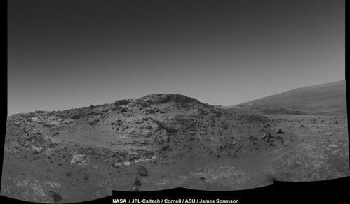
charborob
Jul 14 2016, 11:34 AM
Sol 4433 Lpancam of Hinners Point (waiting for James' color version):

atomoid
Jul 14 2016, 09:32 PM
anaglyph/parallel view of sol4433 boulder field, stitching artifacts compliments of ICE.
Click to view attachment Click to view attachment
jvandriel
Jul 16 2016, 02:45 PM
The Pancam L2 view on Sol 4432.
Jan van Driel
Click to view attachment
brellis
Jul 16 2016, 05:52 PM
Beautiful! Again (as with Victoria) wishing we could name a "Far Side" crater after Gary Larsen.

algorithm
Jul 17 2016, 10:35 AM
ITS BACK!!!!!!
Caught in Navcam frames on Sol 4435
Get out of the wa...saaaand!
Click to view attachment
jvandriel
Jul 17 2016, 01:38 PM
The Navcam L0 view on Sol 4430-4435.
Jan van Driel.
Click to view attachment
Floyd
Jul 17 2016, 01:51 PM
I this a standard 6 foot humanoid, or a life form of a different scale? Fred, what do you think?
James Sorenson
Jul 17 2016, 09:04 PM
QUOTE (charborob @ Jul 14 2016, 03:34 AM)
(waiting for James' color version)
I had suspected that they may do a fairly large color pan here, so I was holding off on uploading that small part of it. Looks like they are!
Here is a small false-color preview of that part in a context Navcam mosaic (excluding the Pancam images that came down today, still processing those).
MoreInput
Jul 18 2016, 08:34 AM
Hello all,
I see your fanatistic panoramas from Oppy since years. Now I search for a solution to view them in real 3D in my Samsung Gear VR device. Has anyone experience with converting panoramas or picture into 360 degree 3D movies (MP4)?
I think it should be possible, but I have no idea where to start.
Thanks,
MoreInput
James Sorenson
Jul 18 2016, 06:52 PM
I'd be interested in knowing how to do that to! I am not aware of anything other than shape from shading techniques. But ultimately the best solution will always be using both the Left and Right eye images and creating a terrain mesh.
Phil Stooke
Jul 18 2016, 08:49 PM
This is Jan's panorama from sols 4423-4425 in circular form, and cropped to focus on the pattern of outcrops here. I would like to have a mosaic of images like this covering the whole valley floor - the part we have explored - geometrically controlled with HiRISE orthoimages. I have played with part of it. Of course it would be better if someone on the science team could make it and then release it...
Phil
Click to view attachment
elakdawalla
Jul 18 2016, 09:06 PM
QUOTE (fredk @ Jul 11 2016, 01:50 PM)
Thanks for pointing that out. I'm used to seeing the monthly PS MER reports on the main PS blog site,
http://www.planetary.org/blogs/, but it seems they no longer post them there.
http://www.planetary.org/explore/space-top...ns/mer-updates/ seems to be the place to look.
Sorry about that, it's related to a bug with the blogs landing page where it's not correctly pulling all the blog entries posted elsewhere on the site. I've reported the problem and it should hopefully be fixed soon. You should always be able to find her articles on the blogs landing page. (And apologies for my late attention to this, I was on vacation.)
scalbers
Jul 18 2016, 09:21 PM
QUOTE (James Sorenson @ Jul 18 2016, 06:52 PM)
I'd be interested in knowing how to do that to! I am not aware of anything other than shape from shading techniques. But ultimately the best solution will always be using both the Left and Right eye images and creating a terrain mesh.
This has been touched upon in a couple of other threads, such as this one:
http://www.unmannedspaceflight.com/index.p...mp;#entry231680Also, note this video from Sitting Duck:
https://www.youtube.com/watch?v=7zW9yISB01YPlus this from Herobrine:
https://www.youtube.com/watch?v=e76uBfWxD74Sean has done some good work too. One can combine 3D meshes using stereo imaging from HIRISE (+ MOLA terrain), then adding textures and doing photogrammetry with the rover images. We might consider a thread with info on the actual software packages.
atomoid
Jul 18 2016, 10:46 PM
QUOTE (algorithm @ Jul 17 2016, 03:35 AM)
ITS BACK!!!!!!
Caught in Navcam frames on Sol 4435
Get out of the wa...saaaand!
Click to view attachmentsand shark seeming somewhat unsatisfied with simple shape silhouettes, may yearn to turn and prefer shiny silicon science strollers instead!!
Click to view attachment(parellel view)
a shame the frames were redacted or subtracted from
sol4435 ("image not yet available", right!) and somehow just missed by
sol4436 pancams.
jvandriel
Jul 19 2016, 07:18 PM
The Pancam L2 view between Sol 4433-4437.
Jan van Driel
Click to view attachment
jvandriel
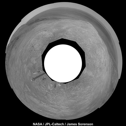
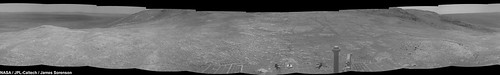
Jul 24 2016, 05:53 PM
The Navcam R0 Panoramic view on Sol 4441-4442.
Jan van Driel
Click to view attachment
Phil Stooke
Jul 24 2016, 09:28 PM
Excellent! Thanks, Jan - here is a circular version of your panorama. The pattern of outcrops and rocks is very apparent.
Phil
Click to view attachment
This is a "lo-fi" version of our main content. To view the full version with more information, formatting and images, please
click here.