Greetings - this map version has some revisions in the area of the two southern basins to try and show more details.
Click to view attachment
Full 4K resolution and polar views are here.
Full Version: Dawn's first orbit, including RC3
QUOTE (Gladstoner @ Jun 6 2015, 06:26 PM) 
If those are central peaks, then that may indicate the white material was drawn up from below in places.
Interesting idea. I was thinking of the ice being quite near the surface everywhere, as at the Mars Phoenix site, and being exposed either by fresh impacts or landsldes on steep slopes, but maybe it's mainly deeper and particular circumstances are required to bring it to the surface.
There is an issue that the dirt overlying the ice may well be denser than the ice. An impact or anything else that disturbs the status quo could trigger some overturning.
scalbers: great map!
It is tricky to discern the orientation of the valleys between the large basin and spot 5, so I took scalber's cylindrical map and brought it into Celestia:
Click to view attachment
Some valleys radiate from the basin, but the ones that extend to spot 5 do not. I thought all the valleys were due to the big basin, but something else seem to be in play.
Click to view attachment
Some valleys radiate from the basin, but the ones that extend to spot 5 do not. I thought all the valleys were due to the big basin, but something else seem to be in play.
QUOTE (scalbers @ Jun 5 2015, 07:07 PM)
Here's a map update with the latest images added:
Click to view attachment
Full 4K resolution and polar views are here.
Click to view attachment
Full 4K resolution and polar views are here.
North West and also ENE of white spots 5 are dark lake-shaped regions of uniform darkness (but not black). Are these just image artifacts or something real?
I'm glad to see such helpful good eyes on this forum. The dark area to the NW (shown below) I think you're referring to would be heavily shadowed craters. I'll check to see how easy it is to substitute another image in that area. Where would be the area to the ENE of spot 5? I also still have to catch up with a map that identifies the white spots.
I was still trying to figure out which lake it was shaped like.
Meanwhile, here's the latest image:
http://dawn.jpl.nasa.gov/multimedia/images...tml?id=PIA19563
Plus a very nice flyover (with slightly exaggerated topography):
http://www.jpl.nasa.gov/video/details.php?id=1380
Phil
Meanwhile, here's the latest image:
http://dawn.jpl.nasa.gov/multimedia/images...tml?id=PIA19563
Plus a very nice flyover (with slightly exaggerated topography):
http://www.jpl.nasa.gov/video/details.php?id=1380
Phil
I ve seen spot 5 in a dream last night.
spot 5 corresponded to a multitude of circular boiling lakes of water.
I became rapidly aware that the fog generated over the lakes exerted a downward pressure that allowed the lakes to remain liquid.
Captivating experience!
spot 5 corresponded to a multitude of circular boiling lakes of water.
I became rapidly aware that the fog generated over the lakes exerted a downward pressure that allowed the lakes to remain liquid.
Captivating experience!
QUOTE (scalbers @ Jun 8 2015, 12:49 PM)
I'm glad to see such helpful good eyes on this forum. The dark area to the NW (shown below) I think you're referring to would be heavily shadowed craters. I'll check to see how easy it is to substitute another image in that area. Where would be the area to the ENE of spot 5? I also still have to catch up with a map that identifies the white spots.
Scalbers, those are the "lakes" to the NE. The ones to the ENE are similar and about 1/4 of the way on a line from the top right corner to area 5. Now that my brain is tuned to shadowed craters, I'm sure that is the story for ENE as well.
QUOTE (Gladstoner @ Jun 8 2015, 08:42 AM)
It is tricky to discern the orientation of the valleys between the large basin and spot 5, so I took scalber's cylindrical map and brought it into Celestia:
Click to view attachment
Click to view attachment
This might be his real color?
QUOTE (Gladstoner @ Jun 6 2015, 05:26 PM)
Here, lower, older rocks were drawn up by the central rebound. The tan in the middle is Cambrian, and the red dot represents huge, rootless blocks of Precambrian granite. The outer ring is younger Ordovician. A cross section of the structure:
Click to view attachment
Click to view attachment
This could be one of the good reasons for central bright spot 5. I hope soon we will know..
QUOTE (scalbers @ Jun 6 2015, 08:29 PM)
Greetings - this map version has some revisions in the area of the two southern basins to try and show more details.
Click to view attachment
Full 4K resolution and polar views are here.
Click to view attachment
Full 4K resolution and polar views are here.
Incredible..
many years, long-awaited and imagined..
and is now fully mapped ..
Thanks,
QUOTE (Daniele_bianchino_Italy @ Jun 9 2015, 08:17 AM)
This might be his real color?
Any color is just an effect of the Celestia rendering. I'm still trying to figure out how to get clean, non-directional lighting on the projected globe.
QUOTE (Ian R @ Jun 5 2015, 04:54 PM)
What a wonderful experiment! I have nothing of any great profundity to say, except that some of your results are very reminiscent of the Voyager Mountains on Iapetus.
Yes Ian R, it reminds the white characteristics over Iapetus surface. Thanks,
QUOTE (jgoldader @ Jun 5 2015, 05:59 PM)
Somebody sop him! He's doing science! 
QUOTE (ZLD @ Jun 5 2015, 06:05 PM)
This is too cool. Very much enjoy such visual simulations.
Many Thanks..
QUOTE (RotoSequence @ Jun 5 2015, 06:07 PM)
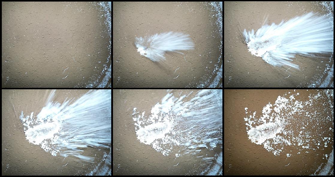
Excellent stuff, Daniele! If you've still got your experiment tray ready to go, could you try making a crater with an extremely shallow angle impact?
Ok, tonight I try a normal angle impact..
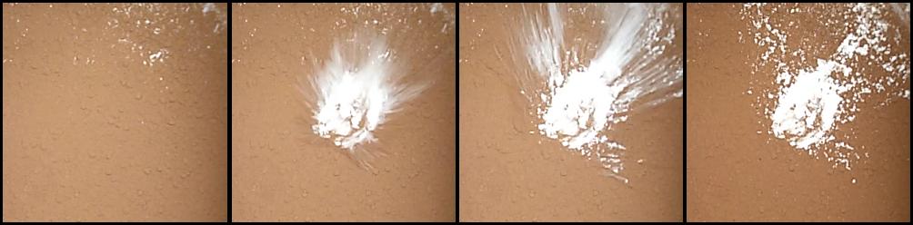
and a low angle impact (it created a crater oblong):
QUOTE (ngunn @ Jun 5 2015, 08:42 PM)
I love to see an experiment, and the cartoon scenarios are also a great basis for discussion. Scenarios b and c look good to me for the various white spots. I would just add that in scenario b the original big impact would likely have exposed fresh ice, subsequently re-covered with dirt before the recent smaller impact event. (You don't need to rely on the coincidence that the large impact narrowly missed going deep enough, allowing the smaller one to finish the job.)
You have reason, was better show exposed fresh ice, subsequently re-covered with dirt.. at that moment I wanted to show craters that had gone more 'in depth, but there are many other possible scenarios for bright spot 5..
Many Thanks
QUOTE (antipode @ Jun 6 2015, 06:37 AM)
That is incredibly cool Daniele, reminiscent of some of Emily's montages. Can I make 2 small suggestions however?
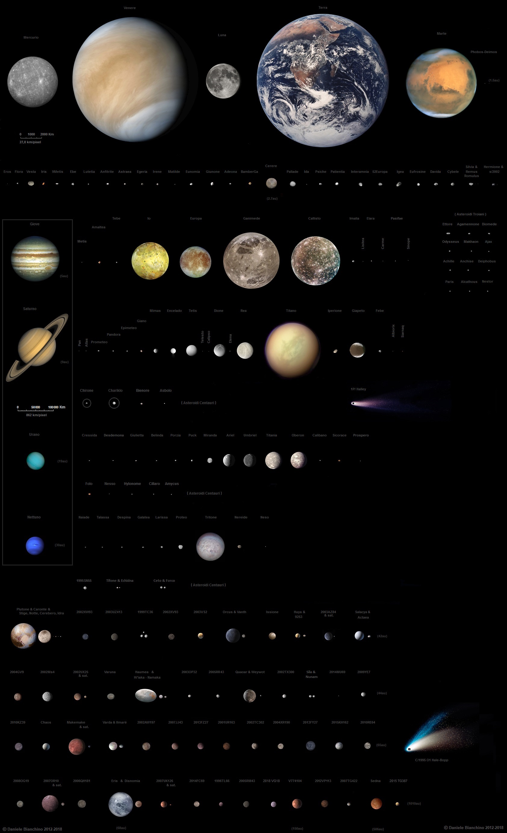
1) The Chariklo image is the only non-photograph, its an artist's conception. Perhaps identify it as such
2) An image of Proteus, to scale, will remind viewers that the transition from 'round' to 'potato' shaped is not a totally predictable one
P
1) The Chariklo image is the only non-photograph, its an artist's conception. Perhaps identify it as such
2) An image of Proteus, to scale, will remind viewers that the transition from 'round' to 'potato' shaped is not a totally predictable one
P
Thanks "antipod",
1. Chariklo is as I have imagined (I have some modified a umbriel moon).
2. It was not a case. I am very fascinated from the small spherical bodies like Mimas or Miranda. I wanted to include just the spherical and small planetary bodies, for paragone at Ceres; for this reason I haven't put irregular bodies like Proteo moon, or Pallas and Iperione. I have included Vesta, a planetary body more 'bigger than others but still uneven, and the others asteroids visited from a Space probes.
One day I try to delete Vesta and I add Proteus moon.. Your advice are welcome, even others, Many Thanks;
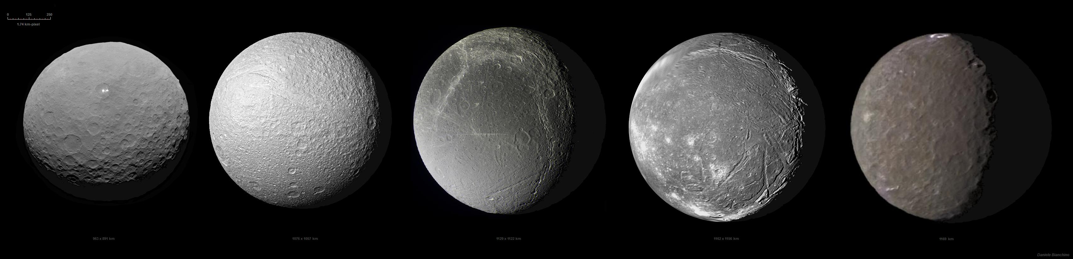
in this collage you can see Ceres compared with Tethis, DIone, Ariel, Umbriel:
To my work I use just simply "paint PC program"; I posted them on my exstrasolar planets website since 2012. They have been modified and updated several times over the years, with new images, new data, new dimensions. I am very precise. I do it for passion only.. .
This is a big work that I did some years ago: 126 corp of the Solar system compared 27,8 km/pixel (also the recent ceres RC3 obviously)
I have another work since 2011, 32 exstrasolar system (850 km / pixel), but I know that can't talk about exstrasolar planets in this Forum;
Sorry for my English,
Many THanks,
Daniele
New image:
http://dawn.jpl.nasa.gov/multimedia/images...tml?id=PIA19564
Three of the craters may show signs of subsidence in their centers:
Click to view attachment
I wonder if the center of spot 5 crater has similar features.
Plus, the crater in the right of the image has scattered bright spots. These are associated with the darkish area known as Piazzi.
Dimmer bright spots in another crater in the latest OpNav 9 image release:
Click to view attachment
Edit: a little late to the party
Click to view attachment
Edit: a little late to the party
QUOTE (Habukaz @ Jun 9 2015, 01:28 PM)
Edit: a little late to the party
Not quite.
I was referring to the big crater that is chopped off on the right edge.
QUOTE (Gladstoner @ Jun 9 2015, 02:26 PM)
New image:
http://dawn.jpl.nasa.gov/multimedia/images...tml?id=PIA19564
Three of the craters may show signs of subsidence in their centers...
http://dawn.jpl.nasa.gov/multimedia/images...tml?id=PIA19564
Three of the craters may show signs of subsidence in their centers...
I don't know, those look more like doming than subsidence to me. In other words, the features you point to look like positive-relief features, not negative-relief as you would expect from subsidence.
-the other Doug
QUOTE (Gladstoner @ Jun 9 2015, 08:34 PM)
Not quite. I was referring to the big crater that is chopped off on the right edge.
I was referring to the big crater that is chopped off on the right edge.I think that the feature you point to there is consistent with a small impact crater whose rim erodes outward irregularly by scarp retreat due to mass wasting by sublimation.
QUOTE (dvandorn @ Jun 9 2015, 02:49 PM)
I don't know, those look more like doming than subsidence to me. In other words, the features you point to look like positive-relief features, not negative-relief as you would expect from subsidence.
I have collapsed domes in mind (central peaks technically are domes.... I think), specifically something resembling a pingo -- sort of. From Wikipedia:
Click to view attachment
Perhaps the central rebound drew up ice-rich material from below (icier than the shallower regolith). This ice, now much closer to the surface, melted/sublimed away, causing the overburden to collapse (subside) into the void, leaving pits or other collapse/subsidence structures behind. Maybe in some cases, salts are drawn to the surface during this deicing process.
This is yet another hypothesis that may be shot down when more evidence comes in, but it is fun to speculate.
QUOTE (Phil Stooke @ Jun 9 2015, 02:55 AM)
Plus a very nice flyover (with slightly exaggerated topography):
http://www.jpl.nasa.gov/video/details.php?id=1380
http://www.jpl.nasa.gov/video/details.php?id=1380
Funny, DLR posted the same video with DLR watermarks and intro on its own website half a day earlier...
http://www.dlr.de/dlr/en/desktopdefault.as...#/gallery/19641
At least JPL kept the credits in it

Region 5 is still a mystery from the Survey orbit. For some reason I find that quite amusing.
Another note:
QUOTE
The region with the brightest spots is in a crater about 55 miles (90 kilometers) across. The spots consist of many individual bright points of differing sizes, with a central cluster. So far, scientists have found no obvious explanation for their observed locations or brightness levels.
"The bright spots in this configuration make Ceres unique from anything we've seen before in the solar system. The science team is working to understand their source. Reflection from ice is the leading candidate in my mind, but the team continues to consider alternate possibilities, such as salt. With closer views from the new orbit and multiple view angles, we soon will be better able to determine the nature of this enigmatic phenomenon," said Chris Russell, principal investigator for the Dawn mission based at the University of California, Los Angeles.
"The bright spots in this configuration make Ceres unique from anything we've seen before in the solar system. The science team is working to understand their source. Reflection from ice is the leading candidate in my mind, but the team continues to consider alternate possibilities, such as salt. With closer views from the new orbit and multiple view angles, we soon will be better able to determine the nature of this enigmatic phenomenon," said Chris Russell, principal investigator for the Dawn mission based at the University of California, Los Angeles.
Another note:
QUOTE
Numerous other features on Ceres intrigue scientists as they contrast this world with others, including protoplanet Vesta, which Dawn visited for 14 months in 2011 and 2012. Craters abound on both bodies, but Ceres appears to have had more activity on its surface, with evidence of flows, landslides and collapsed structures.
New image of the bright spots on June 6th, from 4400 km!
http://dawn.jpl.nasa.gov/multimedia/images...tml?id=PIA19568
http://dawn.jpl.nasa.gov/multimedia/images...tml?id=PIA19568
Also in the release is, among other things, a nice mosaic of one of the two big craters in the southern hemisphere. These scratch marks north (?) of it have an interesting appearance:
Click to view attachment
Click to view attachment
QUOTE (pitcapuozzo @ Jun 10 2015, 01:45 PM)
New image of the bright spots on June 6th, from 4400 km!
http://dawn.jpl.nasa.gov/multimedia/images...tml?id=PIA19568
http://dawn.jpl.nasa.gov/multimedia/images...tml?id=PIA19568
With the image darkened a little, it looks as though some internal structure begins to appear in the white spots.....
Click to view attachment
Those look like compression artifacts to me. I think the "Spot 5" bright spots are still saturated in the released images.
[Maybe the last few posts should be in a new thread?]
Does anyone know if there are plans to target the white spots with shorter exposures from this second mapping orbit?
Does anyone know if there are plans to target the white spots with shorter exposures from this second mapping orbit?
QUOTE (volcanopele @ Jun 10 2015, 08:06 AM)
Those look like compression artifacts to me. I think the "Spot 5" bright spots are still saturated in the released images.
Lots of compression artifacts when zoomed in. Below is a 4x view of white spot 5 with very little processing from the original.
Click to view attachment
The dark streak to the east and attached to the main bright area, heading southeast, is interesting. I don't think that is a processing artifact.
I have to agree that almost none of the bright area is resolved even in this view. However, it almost looks to me that the main bright area is a mound covered by bright material. But that is certainly more imagination than analysis.
Andy
I'm not a photographic expert, could they try taking photographs at a shorter exposure time in order to maybe resolve some internal structure/features inside the spots?
shouldn't we start a new thread? the latest picture has been taken in the survey orbit
"I'm not a photographic expert, could they try taking photographs at a shorter exposure time in order to maybe resolve some internal structure/features inside the spots?"
I'm sure they have done so. The good images are just not released yet.
Phil
I'm sure they have done so. The good images are just not released yet.
Phil
I don't know what the bit depth of the original raw images is, but likely more detail is visible in the bright spots in the original images compared to the press release 8bit/pix images. It's been a while since we've heard if the bright spots are still saturated.
I think the dark streak is a slope directed away from the sun. It looks like it may be part of the boundary of a large collapsed (?) region (arrowed in my image below) inside the main crater.
Click to view attachment
If I'm seeing that correctly, it'd be a good guess that the depression has something to do with the bright spots...
QUOTE (alk3997 @ Jun 10 2015, 04:18 PM)
The dark streak to the east and attached to the main bright area, heading southeast, is interesting. I don't think that is a processing artifact.
I think the dark streak is a slope directed away from the sun. It looks like it may be part of the boundary of a large collapsed (?) region (arrowed in my image below) inside the main crater.
Click to view attachment
If I'm seeing that correctly, it'd be a good guess that the depression has something to do with the bright spots...
QUOTE (Phil Stooke @ Jun 10 2015, 06:25 PM)
I'm sure they have done so. The good images are just not released yet.
Phil
Phil
Thanks, can't wait for those images.
QUOTE (alk3997 @ Jun 10 2015, 09:18 AM)
The dark streak to the east and attached to the main bright area, heading southeast, is interesting. I don't think that is a processing artifact.
Yeah -- the dark streak appears to be a shadow cast by a ridge of some type, as the sun is coming from the bottom of the image. In addition, the extreme blow-up, while rife with compression artifacts, does show that the uppermost of the small white spots is also casting a shadow in the proper direction. It's the only one of the white spots that shows a shadow above it, although that might be more because the reflections are saturating the pixels so much that the shadows from the larger spots are being wiped out.
I'm tempted to think that the fragmentation of the main, central-peak-like white spot along its edges is real, though the details are rather wiped out by the jpeg artifacts.
Two tongue-in-cheek things that occur to me, looking at the zoomed-in image:
1) The secondary white spots look like a long quonset-style building, with smaller outbuildings arranged around it...
2) The main spot looks like the saucer section of a Constitution-class starship, with the longer piece representing the engineering hull. Not much left of the nacelles, just a few small pieces, so they must have blown apart upon impact...
JUST KIDDING! But, hey, with the jpeg artifacts, you can almost convince yourself that you're seeing a regular structure in the high-albedo parts of the image, just as if they were artificial. And obviously, the scale is all wrong for these things to be anything but natural formations. Gonna be really, really interesting to see these features at higher resolution.
-the other Doug
Show time : 3 more !


Please link to the original images at the Dawn website, rather than some image hosting site with pop-up ads.
Phil
Phil
QUOTE (Habukaz @ Jun 10 2015, 03:56 PM)
Also in the release is, among other things, a nice mosaic of one of the two big craters in the southern hemisphere. These scratch marks north (?) of it have an interesting appearance:
Yes that feature did catch my eye also, it resembles glacier shearing, and might be a comparatively young feature.
Ceres spot in the parking lot?
Click to view attachment
Fracture/conduit? Check.
Salt deposits? Check.
There is even a dark halo, but the origin of this one is quite different.
Click to view attachment
Fracture/conduit? Check.
Salt deposits? Check.
There is even a dark halo, but the origin of this one is quite different.
And is that a giant pair of feet?! Aliens confirmed on Ceres! News at 11!
QUOTE (dvandorn @ Jun 10 2015, 03:12 PM)
Yeah -- the dark streak appears to be a shadow cast by a ridge of some type, as the sun is coming from the bottom of the image.
If you look at this earlier image, in the craters lower in the image, especially right above the caption, there are dark deposits that really do not appear to be shadows.
http://solarsystem.nasa.gov/news/display.cfm?News_ID=49244
I would not bet that all the low albedo features in the image you're discussing are shadows.
Here, too, there are dark features on the crater slopes that don't seem to all be shadows:
QUOTE (Gladstoner @ Jun 11 2015, 01:14 PM)
New image, contrast enhanced:Click to view attachment
Great view of the 'sand dollar' in the upper right there. This is a good orbit from which to capture the whole of the Ceres's biggest features within a frame. Soon we will be too close for that.
QUOTE (stevesliva @ Jun 11 2015, 01:32 PM)
Here, too, there are dark features on the crater slopes that don't seem to all be shadows:
Indeed. This darkish area (Piazzi) has been noticed since the early Hubble observations.
QUOTE (dvandorn @ Jun 10 2015, 03:12 PM)
.... things that occur to me, looking at the zoomed-in image:
1) The secondary white spots look like a long quonset-style building, with smaller outbuildings arranged around it...
2) The main spot looks like the saucer section of a Constitution-class starship, with the longer piece representing the engineering hull. Not much left of the nacelles, just a few small pieces, so they must have blown apart upon impact...
Or maybe it's where the underpants gnomes stash their contraband.
This is a section of the floor of the western of the two southern basins, including light and dark markings seen since January. North is at top.
Click to view attachment
As mentioned earlier, I suspect both light and dark markings represent volcanic deposits in regions where the crust is weak. That's why light and dark markings are often found on fault lines and in proximity with one another.
My suspicion is that light-toned spots represent salt gradually deposited over a period, and therefore should show varying degrees of positive relief, depending on how long each site was active. I'm yet to see any spots displaying definite signs of impact-related excavation (the consensus explanation in this forum since day 1). The light-toned area left of centre appears to include a ridge on a fault line. If I'm not being fooled by the lightng angle, two thirds of the way along it is a steep cone-shaped mountain. Judging by other large Cererean basins, that mountain looks too small and steep to be its original central peak. The ridge itself could represent a piece of crust that has been broken and tilted prior to formation of the mountain on top.
And I suspect dark markings result from impacts elsewhere, forcing water to explode through those weak points in the crust, spraying and flooding the area with mud -- the basin floor right of centre has clearly ruptured, just where it is darkest. By the way, just at the top of that rupture is a curious mound with two depressions in it that seems to have formed there sometime after the groove it is sitting on.
In the newest release, another crater with a central pit:
Click to view attachment
This seems to be a recurring theme.
Click to view attachment
This seems to be a recurring theme.
I'm agreeing a lot with John's points above. Especially where he notes that the darkest albedo unit seems to overlay the area around the cracks on the right of the image. This looks like a classic example of fissure volcanism, where the Cerean equivalent of fire fountains sprayed from the fissures, emplacing the Cerean equivalent of pyroclastic material over the surrounding terrain. Compare this to the black/orange/red/brown volcanic glasses on the Moon that were emplaced by ancient fire fountains. (Look up the orange/red soil and dark mantling found at Apollo's Taurus-Littrow landing site for good examples.)
The thing I wonder about is how ancient are the landforms we're seeing? Except for impact alteration, any volcanism (even cryovolcanism) on Ceres driven by internal heat would have to have shut down gigayears ago. I wonder if Ceres would have looked pretty much exactly as it looks now three billion years ago?
-the other Doug
QUOTE (Gladstoner @ Jun 11 2015, 07:14 PM)
Are we sure that is an impact crater?
The Piazzi dark feature, and its proximity to the nearby impact structure, reminds me of the dark pyroclastic halo on the southern rim of Mare Orientale (albeit far more diffuse):
Click to view attachment
Click to view attachment
QUOTE (Gladstoner @ Jun 13 2015, 12:47 AM)
In the newest release, another crater with a central pit: This seems to be a recurring theme.
Indeed, yet smaller craters do seem to often have that central peak we've learned to expect. Even in that image there's a few such craters at lower right.
So was that central pit a bright area similar to spot 5 in the past? If that turn out to be correct, the case for ice grow stronger, since a pit would suggest something have been removed/evaporated, salts could remain though leaving the pit bright so have they dusted over or darkened by some other mechanism.....?
This is a "lo-fi" version of our main content. To view the full version with more information, formatting and images, please click here.