Here's a contrast stretch of the new image, to show surface features in high sun areas more clearly. Some of the smooth patches outside the big basin might be associated with extremely subdued ancient impact features, even more flattened than the big basin itself.
Phil
Click to view attachment
Full Version: Dawn's first orbit, including RC3
After looking today at images of the big basins on Vesta and Hyperion, I wonder how an impact of a similar scale would shape the surface of Ceres. Would isostatic adjustment on the larger world restore the surface closer to its original profile? If so, then perhaps the region with lower crater density and scattered smooth valleys and mounds could be the remains of a really large impact. Some of the valleys and mounds in the region could be what remains of material adjustment and flow of the type that is still prominently displayed in the basin on Vesta. On Ceres, the original rim of the basin could have been mostly obscured by subsequent cratering.
I agree this scenario gives a good account of what we're seeing. It was my impression even from some of the earliest images that there were big impact remnants appearing as mere ghosts. I thought then that they would show some kind of subdued but distict rims as the resolution got better but this never happened. They're still there though, with all the high frequency topography filtered out.
New image (edit: TIF file flipped and converted to JPG.)
Click to view attachment
My goodness. Is this Ceres or Mars?
Click to view attachment
My goodness. Is this Ceres or Mars?
QUOTE (Gladstoner @ Jun 2 2015, 11:38 AM) 
New image (flipped):
...
...
Where is the north pole? I can see a slight brightness change running the whole disc starting from the upper left to the lower right. I'm trying to convince myself this is something real. It's subtle but a sharp line.
Andy
QUOTE (alk3997 @ Jun 2 2015, 01:25 PM)
Where is the north pole?
This is the southern hemisphere. The south pole is at the center of the terminator.
This image contains the south pole. I agree that interesting brightness variations are showing up. Also fewer medium size craters on the west side? Maybe it's brighter from being rougher.
QUOTE (Gladstoner @ Jun 2 2015, 02:28 PM)
This is the southern hemisphere. The south pole is at the center of the terminator.
Thanks - that's very interesting. So, what causes a split in the brightness 45 degrees off of the rotational axis? Is that possibly a disc-long ridge and I'm see the sun reflecting at different angles? I know someone had mentioned an Iapetus-like ridge earlier.
What I find most fascinating are the valleys that have a dendritic appearance.
QUOTE (alk3997 @ Jun 2 2015, 01:39 PM)
So, what causes a split in the brightness 45 degrees off of the rotational axis? Is that possibly a disc-long ridge and I'm see the sun reflecting at different angles? I know someone had mentioned an Iapetus-like ridge earlier.
I'm not sure which feature you're referring to. There so much going on in the image.

QUOTE (Gladstoner @ Jun 2 2015, 02:44 PM)
I'm not sure which feature you're referring to. There so much going on in the image.
I'll have to draw it out when I get home later. It's basically a very subtle, almost straight but not quite, diagonal line running from about 30 degrees counterclockwise from top to approximately 30 degree counterclockwise from bottom. Very subtle.
We are all very good at picking up patterns that aren't there so I'm still wondering about this.
QUOTE (alk3997 @ Jun 2 2015, 01:48 PM)
It's basically a very subtle, almost straight but not quite, diagonal line running from about 30 degrees counterclockwise from top to approximately 30 degree counterclockwise from bottom. Very subtle.
I think I see what you're referring to.
Right now, I'm staring at that basin in two of the recently released images. It is seriously fascinating and confusing. The branching valleys... The somewhat hexagonal outline of the rim... The rectangular central ring -- if that's what it is... The albedo variations... The sharp mountain-like features on the basin floor (if that's what they are)... The 'melted' portion of the rim... The various scarps on the basin floor....
Fun to try and keep catching up with the new images, including today's "dendritic" release. Thus here is a map update.
Click to view attachment
Full 4K resolution and polar views are here.
Click to view attachment
Full 4K resolution and polar views are here.
The big mountain (red arrow) seems to mingle with the valleys and other features surrounding the basin:
Click to view attachment
A spoon-shaped valley (blue arrow) extends from its base.
The green arrow points to a lower mound that seems to sit on one side of a crater.
I'm not sure what all this means....
Click to view attachment
A spoon-shaped valley (blue arrow) extends from its base.
The green arrow points to a lower mound that seems to sit on one side of a crater.
I'm not sure what all this means....
Good morning, I'm Daniele Bianchino, from Italy.
This seems to be the only forum where we analyze the data very well, not science fiction, where I find a lot of opinions, images.
I read this Forum a few days; This seems like the right place for me.
Forgive my English if is not very correct ..
I waited for years Dawn, imagining Ceres; I hoped this was similar to Europa (jupiter moon) like have imagined in Nasa-website; however, I had imagined that this was a heavily cratered body, a mixture from the moons of Saturn and our Moon.
so 'I imagined Ceres for NASA website, before Dawn arrived (Dec. 2015):
http://mondialieni.altervista.org/1_Ceres_...re_planet_0.jpg
I congratulate for your analysis and for the fantastic edited pictures, I see in you the same passion I have inside of me.
1. I think, after careful analysis, All the bright spots correspond to impact craters with "ejecta" of bright material, sometimes willing to rays, as on Mars, the Moon, Mercury. Rarely are small landslides, which highlight the same material.
The "bright spot 5" does not have these characteristics; I dont see the same ejected material in and around the crater. Rather I see something here that has leaked from the fund of the crater, like a eruption-geyser, so as some already 'speculated (ice, salt, brine or sulfur..) or material came from the underground following the big impact; Apparently It similar to Sander Crater, over Mercury, but I think they are very different in material and formation.

2. These fessures seem starting from a large crater in the southern hemisphere (Region 11), south-southeast of the Spot 5:

3. This crater posted by ZLD seems very unusual, more 'deep than other craters, it is strange ....and it also shows ejecta around ,.

4. I hope the "Moun Feature" is an ancient volcano or cryovolcano.
5. There still be the possibility of moons around Ceres?
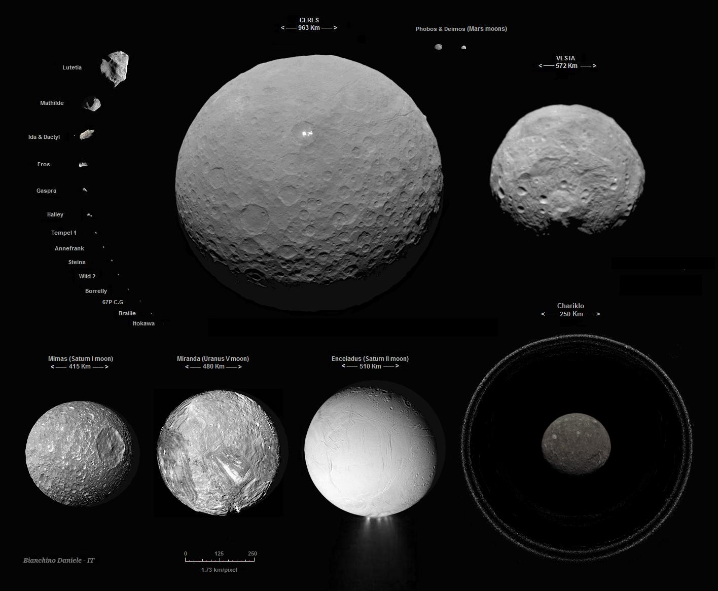
My final accurate collage (1.73km/pixel). Ceres (Rc3), Vesta, Mimas, Miranda, Enceladus, the Mars moons and Chariklo.
I wait for the new, future images
Daniele
This seems to be the only forum where we analyze the data very well, not science fiction, where I find a lot of opinions, images.
I read this Forum a few days; This seems like the right place for me.
Forgive my English if is not very correct ..
I waited for years Dawn, imagining Ceres; I hoped this was similar to Europa (jupiter moon) like have imagined in Nasa-website; however, I had imagined that this was a heavily cratered body, a mixture from the moons of Saturn and our Moon.
so 'I imagined Ceres for NASA website, before Dawn arrived (Dec. 2015):
http://mondialieni.altervista.org/1_Ceres_...re_planet_0.jpg
I congratulate for your analysis and for the fantastic edited pictures, I see in you the same passion I have inside of me.
1. I think, after careful analysis, All the bright spots correspond to impact craters with "ejecta" of bright material, sometimes willing to rays, as on Mars, the Moon, Mercury. Rarely are small landslides, which highlight the same material.
The "bright spot 5" does not have these characteristics; I dont see the same ejected material in and around the crater. Rather I see something here that has leaked from the fund of the crater, like a eruption-geyser, so as some already 'speculated (ice, salt, brine or sulfur..) or material came from the underground following the big impact; Apparently It similar to Sander Crater, over Mercury, but I think they are very different in material and formation.
2. These fessures seem starting from a large crater in the southern hemisphere (Region 11), south-southeast of the Spot 5:
3. This crater posted by ZLD seems very unusual, more 'deep than other craters, it is strange ....and it also shows ejecta around ,.
4. I hope the "Moun Feature" is an ancient volcano or cryovolcano.
5. There still be the possibility of moons around Ceres?
My final accurate collage (1.73km/pixel). Ceres (Rc3), Vesta, Mimas, Miranda, Enceladus, the Mars moons and Chariklo.
I wait for the new, future images
Daniele
QUOTE (Gladstoner @ Jun 3 2015, 02:36 AM)
The big mountain (red arrow) seems to mingle with the valleys and other features surrounding the basin:
There was actually a pretty good view of this basin on the limb from the the RC3 animation.
Click to view attachment
Would definitely say they are related features.
Supposing that the bright spots on Ceres are caused by impacts, why does the area around site 5 not have the same sort of scattered, light-colored debris? If something struck hard enough to cause the eruption of material from beneath the surface, shouldn't it also have thrown material out into the surrounding area, as it appears may be the case with the other bright spots?
^ They could be caused by a small(er) object that broke up before impact and hit an area with a higher subsurface concentration of some bright stuff (which would explain why there aren't more areas truly like this one despite the higher frequency of impacts by smaller objects - or alternatively that the material darkens relatively quickly such that any other similar areas are now all grey in the images).
Maybe spot 5 is a recent impactor, which happened to be small - too small for us to see the crater itself yet in the glare. The impactor would have been a rubble pile with 1 larger piece and several smaller pieces that split off and then fragmented before impact.
Does ejecta on Ceres age at different rates depending upon the distance from the impact? Ejecta fairly far away will be small and sublimate away the white ice quickly, leaving the darker slag. But ejecta closer is going to be larger and thicker, and last longer before darkening.
Also, if it is on a slope I think the change in mass as it sublimates away could cause instabilities, with boulder disintegration and small scale landslides exposing fresh ejecta ice surfaces. That's what spot 1 looks like to me. Middle aged ejecta will all the primary ejecta darkened, and only exposed landslide ejecta brighter.
My guess is that Spot 5 is an impact, less than a 1,000 years old and probably much younger than that. That's just a gut feeling based on http://www.jpl.nasa.gov/news/news.php?feature=4380 and Ceres surface area equaling India.
QUOTE (Daniele_bianchino_Italy @ Jun 3 2015, 03:09 PM)
Good morning, I'm Daniele Bianchino, from Italy. I wait for the new, future images Daniele
WOW ! Thanks a lot Daniel for this nice collage of yours.

And "Viva Italia" ! (Aaahhh ! Rome....)
Cheers, VM (a 'cousin' from France...)
Another forum user pointed out in this thread that there's a long fault line going along Ceres' surface and right through the crater with the bright spots. Since the location of the main bright spot is in the centre of that crater, I think it's possible that the bright spot is where the "rebound" action that creates familiar central peaks in craters, brought up underlying material of salts or other bright or very reflective minerals.
The third in line of the big southern impact features that are all on parade here, formerly a 'ghost,' now has a distictly visible northern rim extending over about one quarter of its circumference (just above and right of centre here). I find this feature interesting because I think it is a transitional case between ancient large impact features that are very subdued but still have distinct rims (like the sand dollar) and others that don't.
These are big features that stand out in the earlier low resolution imagery but tend to be harder to see as more detail appears, unless as in this case a bit of the rim survives.
These are big features that stand out in the earlier low resolution imagery but tend to be harder to see as more detail appears, unless as in this case a bit of the rim survives.
Thanks for the new image post, Gladstoner. It shows off very well what I've been seeing -- a lot of units emplaced over large craters and basins.
On this new image, there is a large basin that has been overlain by a field of what appears to be impact-emplaced ejecta from another basin. I have circled the basin in green in my annotated image, and traced the edges of the overlying unit in blue. (Very roughly, obviously.) The overlying unit is noticeably raised above the unit underlying, and appears to develop cracks on the far left extent (in this image) of its emplacement.
-the other Doug
Click to view attachment
QUOTE (ZLD @ Jun 3 2015, 09:17 AM)
There was actually a pretty good view of this basin on the limb from the the RC3 animation.
I didn't notice it the first time, but I did go back to take a look after the new image release.
It just shows that it'll take a lot of staring at the photos to draw out all the details. No problem there....
I'd have to say Ceres is becoming one of my favorite worlds. It's everything I'd hope it would be, i.e. a 'representative' primitive body with personality. It has a simple elegance, yet there are so many intriguing structures and details that will puzzle and fascinate researchers and enthusiasts for years to come.
A problem with impact exposure of ice and/or light-colored minerals at the site 5 bright spots is that they are relatively bright, compact, and numerous, in comparison to the other areas of bright spots on Ceres. Explaining this difference seems to require a chain of coincidences:
1.) The impactor would have broken up before reaching the surface. This, despite the fact that Ceres has negligible gravity and less atmosphere, which could contribute to such a break up.
2.) The break up of the impactor would have occurred very near the surface, in order to confine the impacts to a relatively small portion of the crater.
3.) The ice or light-colored minerals would have to be very near the surface, so that small impacts could expose them.
QUOTE (dudley @ Jun 4 2015, 10:38 AM)
A problem with impact exposure of ice and/or light-colored minerals at the site 5 bright spots is that they are relatively bright, compact, and numerous, in comparison to the other areas of bright spots on Ceres. Explaining this difference seems to require a chain of coincidences:
1.) The impactor would have broken up before reaching the surface. This, despite the fact that Ceres has negligible gravity and less atmosphere, which could contribute to such a break up.
2.) The break up of the impactor would have occurred very near the surface, in order to confine the impacts to a relatively small portion of the crater.
3.) The ice or light-colored minerals would have to be very near the surface, so that small impacts could expose them.
1.) The impactor would have broken up before reaching the surface. This, despite the fact that Ceres has negligible gravity and less atmosphere, which could contribute to such a break up.
2.) The break up of the impactor would have occurred very near the surface, in order to confine the impacts to a relatively small portion of the crater.
3.) The ice or light-colored minerals would have to be very near the surface, so that small impacts could expose them.
I think I could explain that with the impactor being a rubble pile, with the velocity being relatively low between Ceres and the impactor.
Yes, the light material would have to be near the surface or the impactor provided the light material.
Andy
QUOTE (alk3997 @ Jun 4 2015, 11:28 AM)
I think I could explain that with the impactor being a rubble pile, with the velocity being relatively low between Ceres and the impactor.
Yes, the light material would have to be near the surface or the impactor provided the light material.
Andy
Yes, the light material would have to be near the surface or the impactor provided the light material.
Andy
Was about to post this exact idea as well. I think its entirely possible, but its not my favorite hypothesis. There are still a lot of other bright spots across the dwarf planet that share some similarity. Also, if you look back at the 'Spot 5' centric animation I made, if you pay close attention, you can see the edges of the spots do something like a twinkling, as if it were crystalline.
I don't see the three items as a problem.
Imagine Ceres as covered by a a light-toned evaporite, formed from a "salty" ocean covering the whole surface.
Bright material gets a thin dark surface on long-term exposure to space, due to radiation and micrometeorites.
Visible light penetrates just the first few micrometers; those are relevant for color.
Bright spots would form anywhere by impacts above a certain size, exposing the bright subsurface. (answering 3)
Asteroids above some size are thought to be rubble piles. Those rubble piles break up near the Roche limit; Ceres' gravity is well-sufficient to cause this break-up. (answering 1)
The Roche limit for Ceres is below about 2000 km for most asteroids. The break-up is slow in comparison to the velocity of an asteroid; fragment trajectories tend to be constraint. (answering 2)
Why the briny ocean?
This can be inferred from Ceres' low density, indicating high water content. This water would be enriched within a surface-near shell of several 10s of kilometers thickness. The layer above, made of primordial material (mostly ice/silicate mix), is too dense to be stable on a liquid mantle, hence sinks down, partially also driven by large impacts.
The subsurface ocean would form by heating from long-term radioactive decay.
Water in contact with silicates like olivine or feldspar weathers those slicates to clay minerals and "salts". The clays sink to the ground, the salts stay in solution.
The brine freezes at some point in time and proximity to the surface. As exposed to near-surface the water sublimates from the brine and leaves the bright evaporites ("salts").
Thick ice crusts slowly convect from radioctive core heat. This enriches the better-soluble salts in the outer layers of the crust over time, since less-soluble salts tend to precipitate sooner and sink to the ground of the ocean, as long as there is liquid intermediate layer of brine.
Edit: Paper of some of Ceres-specific background.
Trying to visualize some possible processes that could produce bright spots....
1. White material is in isolated spots and covered with regolith. Impacts and slides expose it in places:
Click to view attachment
2. White material is extensive and rapidly fades due to weathering processes. It is occasionally exposed by impacts and slides:
Click to view attachment
1. White material is in isolated spots and covered with regolith. Impacts and slides expose it in places:
Click to view attachment
2. White material is extensive and rapidly fades due to weathering processes. It is occasionally exposed by impacts and slides:
Click to view attachment
So Dawn arrived at its 'survey orbit' yesterday and will start new observations tomorrow. Time for a new thread soon.
My primary problem with the irradiated salt hypothesis has been with the lack of in-between stages. There seems to be dark asphalt, or new concrete options for luminance on Ceres. Maybe 'Spot 5' is so reflective because it is fresh and the other lesser spots are already long in the process of darkening. The volcano-like mound also has a high luminance though. How would irradiated salt account for that unless it was recently active or local seismic activity with a landslide? This is probably an area where color data would greatly benefit.
QUOTE (ZLD @ Jun 4 2015, 08:31 PM)
The volcano-like mound also has a high luminance though.
My impression is that it has two steep slopes flanking a short summit ridge and that it's mainly those steep slopes that are bright. They could be near the angle of repose and behave like active screes, vulnerable to the slightest disturbance.
The latest image is a nice 'family portrait' of Ceresian terrains and features.
Click to view attachment
Included are:
A. 'Standard' heavily-cratered terrain.
B. Hummocky resurfaced terrain.
1. Large, complex basins.
2. Craters of all sizes and conditions.
3. Broad, smooth valleys (and scarps & mounds).
4. Sharp, sinuous valleys.
5. Fracture-like chain-of-crater valleys.
6. Bright spots.
7. The big mountain.
QUOTE (vikingmars @ Jun 3 2015, 05:39 PM)
WOW ! Thanks a lot Daniel for this nice collage of yours.
http://mondialieni.altervista.org/Ceres_Ve...awn_Lutetia.jpg
http://mondialieni.altervista.org/Ceres_Ve...awn_Lutetia.jpg
Many Thanks vikingmars!
little experiment. I have used one layer of farine, one layer of cacao..
visible ejecta of the bright material. The craters that have formed are similar to some of Ceres crater with ejecta (like bright Spot 1), but no one is similar to the bright Spot 5.


TheSe my three possible scenarios (but might be others?):

What a wonderful experiment! I have nothing of any great profundity to say, except that some of your results are very reminiscent of the Voyager Mountains on Iapetus.
Somebody stop him! He's doing science! 
QUOTE (Daniele_bianchino_Italy @ Jun 5 2015, 11:10 AM)
Many Thanks vikingmars!
little experiment. I have used one layer of farine, one layer of cacao..
visible ejecta of the bright material. The craters that have formed are similar to some of Ceres crater with ejecta (like bright Spot 1), but no one is similar to the bright Spot 5.
little experiment. I have used one layer of farine, one layer of cacao..
visible ejecta of the bright material. The craters that have formed are similar to some of Ceres crater with ejecta (like bright Spot 1), but no one is similar to the bright Spot 5.
This is too cool. Very much enjoy such visual simulations.
Excellent stuff, Daniele!
If you've still got your experiment tray ready to go, could you try making a crater with an extremely shallow angle impact? I'd try it myself, but I think I'd get some stern looks of disapproval for wasting food and making a mess.
If you've still got your experiment tray ready to go, could you try making a crater with an extremely shallow angle impact? I'd try it myself, but I think I'd get some stern looks of disapproval for wasting food and making a mess.
I love to see an experiment, and the cartoon scenarios are also a great basis for discussion. Scenarios b and c look good to me for the various white spots. I would just add that in scenario b the original big impact would likely have exposed fresh ice, subsequently re-covered with dirt before the recent smaller impact event. (You don't need to rely on the coincidence that the large impact narrowly missed going deep enough, allowing the smaller one to finish the job.)
Same thing, different day (i.e. TIF flipped, JPG'd):
Click to view attachment
It would be interesting to know why the images end up reversed.
Click to view attachment
It would be interesting to know why the images end up reversed.
Here's a map update with the latest images added:
Click to view attachment
Full 4K resolution and polar views are here.
Click to view attachment
Full 4K resolution and polar views are here.
QUOTE (Gladstoner @ Jun 5 2015, 05:52 PM)
It would be interesting to know why the images end up reversed.
_Very_ good question. I was starting to notice that things didn't look "quite right" and then I saw that you were noting "flipped" on your images. If I'm catching this correctly it looks like the images started to be reversed with the Southern Hemisphere campaign, PIA19554. Not a big deal, but an annoyance with annotated images.
--Bill
QUOTE (Bill Harris @ Jun 5 2015, 08:44 PM)
If I'm catching this correctly it looks like the images started to be reversed with the Southern Hemisphere campaign, PIA19554.
At least toilets on Ceres will now flush in the same direction as in the north.
QUOTE
That is incredibly cool Daniele, reminiscent of some of Emily's montages. Can I make 2 small suggestions however?
1) The Chariklo image is the only non-photograph, its an artist's conception. Perhaps identify it as such
2) An image of Proteus, to scale, will remind viewers that the transition from 'round' to 'potato' shaped is not a totally predictable one
P
I'm really enjoying Ceres now. A great intermediary between the silicate worlds and the ice moons & TNOs. Onwards, closer!
Looking back at this image I now think the big mountain may be the remains of the central peak of an almost-erased impact basin similar in size to the one at the lower left terminator here:
http://www.unmannedspaceflight.com/index.p...st&id=35981
That crater also has a central peak that takes the form of a short linear ridge with at least one white patch on its northern slope:
http://www.unmannedspaceflight.com/index.p...st&id=35989
http://www.unmannedspaceflight.com/index.p...st&id=35981
That crater also has a central peak that takes the form of a short linear ridge with at least one white patch on its northern slope:
http://www.unmannedspaceflight.com/index.p...st&id=35989
QUOTE (ngunn @ Jun 6 2015, 04:20 AM)
Looking back at this image I now think the big mountain may be the remains of the central peak of an almost-erased impact basin similar in size to the one at the lower left terminator here:
http://www.unmannedspaceflight.com/index.p...st&id=35981
That crater also has a central peak that takes the form of a short linear ridge with at least one white patch on its northern slope:
http://www.unmannedspaceflight.com/index.p...st&id=35989
http://www.unmannedspaceflight.com/index.p...st&id=35981
That crater also has a central peak that takes the form of a short linear ridge with at least one white patch on its northern slope:
http://www.unmannedspaceflight.com/index.p...st&id=35989
If those are central peaks, then that may indicate the white material was drawn up from below in places. The Decaturville impact structure in Missouri comes to mind:
Click to view attachment
Here, lower, older rocks were drawn up by the central rebound. The tan in the middle is Cambrian, and the red dot represents huge, rootless blocks of Precambrian granite. The outer ring is younger Ordovician. A cross section of the structure:
Click to view attachment
(Edit: ring faults not included in diagram for simplicity.)
If this happened on Ceres, the sparse nature of the white stuff could indicate an overall spotty distribution, an occurrence at varying depths, or both.
This is a "lo-fi" version of our main content. To view the full version with more information, formatting and images, please click here.