Full Version: Rosetta - Early Orbital Operations at Comet 67P C-G
Other possible boulder trails on the lower right side of this navcam ?
Navcams from october 3 Draped over my shapemodel.
Anaglyph:
http://youtu.be/f5p8y2-5Gqg
3DTV:
http://youtu.be/rU5cG41SAYI
Plain mono version:
http://youtu.be/Y-E3UDT8iEA
http://mattias.malmer.nu/2014/10/comet-on-...avcam-the-rift/
Anaglyph:
http://youtu.be/f5p8y2-5Gqg
3DTV:
http://youtu.be/rU5cG41SAYI
Plain mono version:
http://youtu.be/Y-E3UDT8iEA
http://mattias.malmer.nu/2014/10/comet-on-...avcam-the-rift/
at last we are fed an OSIRIS image!
BOULDER CLOSE-UP
BOULDER CLOSE-UP
OSIRIS is such an incredible camera. There is no doubt we'll se Philae once on the ground. One question about taking pictures of Philae just after release. Will this help double checking how good/bad was the actual release...i.e speed and angle? Thanks
Wow - yes, a boulder... and a first feature name. I look forward to getting more of those very soon.
Phil
Phil
Speaking of feature names I'm surprised we still have no names for the 'body' and 'head'. 'Egypt' and 'Nubia' perhaps?
QUOTE (Paolo @ Oct 9 2014, 02:07 PM) 
BOULDER CLOSE-UP
To think...the lander could fit easily onto a smooth part of that boulder...
This is surely not the full OSIRIS image unless I'm missing the link buried on the page. In effect, there is still the policy of "redaction by extreme cropping" for the time being. I'm grateful to see this taste of the bigger picture, but not as excited as if it were the full frame, which I expect would include some of the interesting rough country to the 4 o'clock direction of Cheops. There is a "stele" or two down there, visible in the lowered-res August picture of the region, that really intrigue me.
Presumably the landing day coverage will include the target area in full-res, just to have something to compare the Phiale images with. Still a month away....
QUOTE (Malmer @ Oct 9 2014, 07:22 AM)
Navcams from october 3 Draped over my shapemodel.
Toward the end of this animation, the movement really brings out the uniqueness of the pillar shapes and edifices overlooking the far end of the valley. I knew I had seen something like that before: Urania's destruction on "The Phantom Empire". When pareidolia meets movie memes...
Click to view attachment Click to view attachment
(Edit: added the corresponding view of the "Empire" above the valley--both strange and familar.)
I'm not sure exactly what you're referring to, but there are projection artifacts in the animation crop you posted. Here's the corresponding area from Thomas Appéré's stitch posted above:
Click to view attachment
There still are some stitching artifacts, due to the substantial rotation between frames, but no strange "pillar shapes", which you can also see from the original navcam frames.
Click to view attachment
There still are some stitching artifacts, due to the substantial rotation between frames, but no strange "pillar shapes", which you can also see from the original navcam frames.
Finally, a piece of an OSIRIS picture taken from a distance of about 30 km.
A nice boulder named Cheops in the middle of very smooth terrain !
http://blogs.esa.int/rosetta/2014/10/09/boulder-close-up/
A nice boulder named Cheops in the middle of very smooth terrain !
http://blogs.esa.int/rosetta/2014/10/09/boulder-close-up/
I posted a question about this image on the ESA blog but it's still "awaiting moderation." The boulder is reported to be 45 meters across, and the image is stated to have a resolution of 50 cm per pixel. But if you measure the boulder you'll find it's 200 pixels across, so either the reported width or resolution is off by a factor of roughly two. To my eye, the image looks blurry, as though it's been enlarged, so I'm inclined to think they doubled the size of the image before posting it, but I can't be sure. (If they did double it, we're looking at a very tiny crop indeed from a full 2048-pixel-square OSIRIS frame.)
My money's also on a magnified section of a full OSIRIS frame.
OK, it's just been confirmed to me privately that the image has been enlarged by slightly more than 200% from its original resolution. Therefore it represents about 9% of a full OSIRIS frame (by area).
QUOTE (elakdawalla @ Oct 10 2014, 02:47 AM)
OK, it's just been confirmed to me privately that the image has been enlarged by slightly more than 200% from its original resolution. Therefore it represents about 9% of a full OSIRIS frame (by area).
There are a few pixels of information in there non the less.
An Ascent from Cheops
http://youtu.be/-FTnzOLydqM
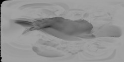
Now since I do not have stereo coverage here I resorted to another computer vision technique called Shape From Shading. I make the assumption that the surface has constant albedo. Then any difference in value must be the result of the surface leaning towards or away from the sun. I convolve the image with a special convolve kernel that generates scanlines of elevation data. They are filtered to remove banding.
...and with a fair sprinkling of Dragons Tooth in the Full Moon Light I can conjure up an elevationmap.
Then I drape it with the images and we are good to go!
/M
My attempt to mark with red ellipses the area indicted by the ESA's white ellipse for landing site J. The bottom image is the latest from 18 km.
Click to view attachment
Click to view attachment
QUOTE (elakdawalla @ Oct 10 2014, 02:47 AM)
OK, it's just been confirmed to me privately that the image has been enlarged by slightly more than 200% from its original resolution. Therefore it represents about 9% of a full OSIRIS frame (by area).
What a shame ! They are not even willing to release to the public a real OSIRIS image !
Only a tiny cropped section... and they had enlarged it as if they wanted to show us more details...
The space community and Rosetta followers shall be deserved more respect from the OSIRIS team

QUOTE (elakdawalla @ Oct 10 2014, 02:47 AM)
OK, it's just been confirmed to me privately that the image has been enlarged by slightly more than 200% from its original resolution. Therefore it represents about 9% of a full OSIRIS frame (by area).
If 45 meter diameter of the Cheops and 0.5 m/pix resolution are correct informations then it's 250% enlarged and it covers slightly more than 6% of full OSIRIS frame.
But I have different problem with this image. It is actually cropped in such way that it shows almost nothing (Cheops and very smooth area without details).
Here is context for this cropped image:
QUOTE (machi @ Oct 11 2014, 11:42 AM)
...cropped in such way that it shows almost nothing (Cheops and very smooth area without details).
Thanks Machi for your calculations.
Yes, indeed They are treating us, as we say in French pro-space organizations, with "news without news" !
Do you remember Halley's comet fly-by by Giotto with the "Halley Multicolour Camera" in 1986 ? It was built by the Max Planck Institute... again !
In 1986, we were only treated with those "multicolour" images no one could understand.
Click to view attachment
At Societe Astronomique de France, with the help of TPS also, we had to make almost 2 years lobbying to ESA then to get released the REAL images from Horst Uwe Keller to be printed in magazines to the public (before, they were only to be seen inside printed scientific magazines such as Nature and Science)...
Apparently there is still a loooong tradition at the Max Planck Institute to keep the data for themselves and do no EPO.
Shame on them.
QUOTE (machi @ Oct 11 2014, 04:42 AM)
If 45 meter diameter of the Cheops and 0.5 m/pix resolution are correct informations then it's 250% enlarged and it covers slightly more than 6% of full OSIRIS frame.
But I have different problem with this image. It is actually cropped in such way that it shows almost nothing (Cheops and very smooth area without details).
Here is context for this cropped image:
But I have different problem with this image. It is actually cropped in such way that it shows almost nothing (Cheops and very smooth area without details).
Here is context for this cropped image:
At least they left the rock in the released image. Could have been just the smooth area...

Here's hoping we don't get, "We're delighted to tell you all Philae has landed, and you can see the remarkable images in about 6 months, if you subscribe to Science."
My take on the mosaic of 8 October 2014:

I just finished updating my digital terrainmodel to include the "belly" of the comet.
This latest NavCam set was a good way testing its fidelity. I am quite happy with the resulting accuracy.
Movies:
Mono
http://youtu.be/UBYUUfKAtRk
Anaglyph
http://youtu.be/sepETzbhTL8
3DTV
http://youtu.be/Q-0afotpZgA
images:
Mono:
http://mattias.malmer.nu/wp-content/upload...0/rise_mono.jpg
Anaglyph:
http://mattias.malmer.nu/wp-content/upload...se_ANAGLYPH.jpg
QUOTE (Malmer @ Oct 12 2014, 01:34 PM)
I just finished updating my digital terrainmodel to include the "belly" of the comet.
WOW ! CONGRATULATIONS ! Thanks so much Malmer sharing this great work of yours with us

Malmer, I hope you release your 3D model + global texture sometime in the future.
I'd very much like to add it to a free space simulator. Rosetta is already simulated, but the comet is generic:
http://www.orbithangar.com/searchid.php?ID=3466

For this purpose, it doesn't have to be too accurate or detailed.
I'd very much like to add it to a free space simulator. Rosetta is already simulated, but the comet is generic:
http://www.orbithangar.com/searchid.php?ID=3466

For this purpose, it doesn't have to be too accurate or detailed.
QUOTE (4throck @ Oct 12 2014, 05:13 PM)
Malmer, I hope you release your 3D model + global texture sometime in the future.
I'd very much like to add it to a free space simulator. Rosetta is already simulated, but the comet is generic:
http://www.orbithangar.com/searchid.php?ID=3466
For this purpose, it doesn't have to be too accurate or detailed.
I'd very much like to add it to a free space simulator. Rosetta is already simulated, but the comet is generic:
http://www.orbithangar.com/searchid.php?ID=3466
For this purpose, it doesn't have to be too accurate or detailed.
I have yet to produce a global texture. (struggling with deciding on what mapping projection to use.) But you can download my work in progress mesh here:
http://mattias.malmer.nu/67pc-g-shapemodel/
It is not perfectly to scale and its center is not perfectly placed and it is slightly off in orientaton. I have no good data to go on so I'm keeping it with this transformation until I find a good source for this data.
you might need to flip it 90 degrees on some axises depending on the coordinate preferences of you software (as usual)
Send a screenshot if you get it to work in your sim.
/Mattias
QUOTE (vikingmars @ Oct 12 2014, 01:45 PM)
WOW ! CONGRATULATIONS ! Thanks so much Malmer sharing this great work of yours with us
Thank you. I'm happy that you like it. I think mapping the images to a model and giving it depth makes it a bit easier to get a feel for the surface.
I made a crappy gravity vector simulation. I'm wrongly assuming that the comet is of constant density and is not spinning because that was just to much math for one night...
With that I can see what direction down is on various areas of the comet. It becomes easier to try to understand some of the surface features then. Might post something as soon as I come up with a clever way of visualizing it.
QUOTE (Malmer @ Oct 12 2014, 10:03 PM)
I have yet to produce a global texture. (struggling with deciding on what mapping projection to use.) But you can download my work in progress mesh here:
http://mattias.malmer.nu/67pc-g-shapemodel/
It is not perfectly to scale and its center is not perfectly placed and it is slightly off in orientaton. I have no good data to go on so I'm keeping it with this transformation until I find a good source for this data.
you might need to flip it 90 degrees on some axises depending on the coordinate preferences of you software (as usual)
Send a screenshot if you get it to work in your sim.
/Mattias
Thanks :-)
The model is quite high poly, Blender on my not so modern machine struggles with it. I'll try to generate a low poly version of your mesh, that should be enough for a free simulator.
For real-time graphics on low end hardware the best results come from using a global texture, with shadows and all.
It simply looks best on a 10000k polygon model (or lower).
I have Phil's texture from earlier on the thread so... let's see where that leads :-)
I have a low-poly version of mine here
https://googledrive.com/host/0B6ZYAd08tZL-V....09.30.2014.zip
it is a 1.3 meg mesh
at a resolution of 1 pixel per degree
mesh only no remapped texture other than the lat / long grid
this is only an approximation and still needs work
https://googledrive.com/host/0B6ZYAd08tZL-V....09.30.2014.zip
it is a 1.3 meg mesh
at a resolution of 1 pixel per degree
mesh only no remapped texture other than the lat / long grid
this is only an approximation and still needs work
QUOTE (jgoldader @ Oct 11 2014, 12:47 PM)
Here's hoping we don't get, "We're delighted to tell you all Philae has landed, and you can see the remarkable images in about 6 months, if you subscribe to Science."
Regarding the Philae cameras, the CIVA team with Jean-Pierre Bibring is used to EPO policies and knows well how to behave with the international Pro-Space community.
Also, they are great professionals and behave in a much friendly mood that the Max Planck Institute : the CIVA team plans to release to the Press a panoramic picture at the soonest after the landing.
Regarding the OSIRIS team for a picture showing Philae on the nucleus after its landing : ask Holger Sierks (like many others, I quit !)
ADMIN NOTE: To All. Could we be mindful of the unnecessary comments about the image release policy on the Rosetta mission. This point has been endlessly debated and commented upon through lots of blogs and forums. The policy is what it is. I'd also remind everyone of Forum rule 2.6 which extends to mission teams as well as individuals.
QUOTE (JohnVV @ Oct 12 2014, 11:12 PM)
I have a low-poly version of mine here...
That will work out of the box, thanks! So only the global texture to go.
I can try to generate a global normal or shadow map from Malmer's high resolution model.
That might work and help in registering the global images. Will see what I can do...
.......
Here's a shadow map. Of course, coordinates are "equator goes through the neck" and probably some areas are superimposed, but it's usable to identify large areas:
The darker area is the neck. Since this is a shadow map, less exposed areas look darker.
(Don't know if this is the right place to discuss maps / textures. Perhaps we should move it to mapping topic?)
4throck
that would be the other thread that was split off of this one
http://www.unmannedspaceflight.com/index.php?showtopic=7883
and see the post #110 of that thread
http://www.unmannedspaceflight.com/index.p...st&p=213529
the northpole on mine is in the center of the map i posted
the 8 bit DEM
the issue is getting things aligned to use the shape to warp the esa images to make a simple cylindrical image
QUOTE (Malmer @ Oct 9 2014, 12:22 PM)
Your videos are amazing, but way too short to be enjoyed! I suggest making a multiple forward-revrse-forward version of them, making them last at least 40 or 50 seconds.
I think this tool, this model and this service could be used to have our own 3d models of C-P comet on our deks :-) , but I think it'll take a bit long, don't know if I will be able to have my model printed in time before Philae landing.. :-/
I tried uploading to sculpteo.com a raw STL version of the model, but a 2x2x2 inches print would cost around 30$... :-( So we need the above tool to hollow the model and make it cheaper. I am not skilled with Filament FMD printers, but maybe thay would automatically print a model as hollow object. Anybody skilled in 3d printing here?
I tried uploading to sculpteo.com a raw STL version of the model, but a 2x2x2 inches print would cost around 30$... :-( So we need the above tool to hollow the model and make it cheaper. I am not skilled with Filament FMD printers, but maybe thay would automatically print a model as hollow object. Anybody skilled in 3d printing here?
QUOTE (mcgyver @ Oct 13 2014, 10:05 PM)
Your videos are amazing, but way too short to be enjoyed! I suggest making a multiple forward-revrse-forward version of them, making them last at least 40 or 50 seconds.
Good point... Will try to do that in the future. I might do a compilation of them at some point aswell.
I read this interview with Holger Sierks. He talks about the OSIRIS camera having "limited lifetime items". What are those?
http://cumbriansky.wordpress.com/2014/08/1...-holger-sierks/
http://cumbriansky.wordpress.com/2014/08/1...-holger-sierks/
QUOTE (Malmer @ Oct 14 2014, 03:54 PM)
"limited lifetime items". What are those?
Maybe one is coolant for the CCD's?
QUOTE (Malmer @ Oct 14 2014, 09:54 AM)
I read this interview with Holger Sierks. He talks about the OSIRIS camera having "limited lifetime items". What are those?
Page 38 of this technical document says:
QUOTE
A complicating factor is that the calibration lamps have a limited lifetime.
Rosetta: Spying on a Mysterious Comet
Fun double header presentaiton by Dr. Claudia Alexander, the US Rosetta Project Scientist and Art Chmielewski, the US Project Manager.
Fun double header presentaiton by Dr. Claudia Alexander, the US Rosetta Project Scientist and Art Chmielewski, the US Project Manager.
The BBC has posted a video taking a close up look at the Philae lander. They show the attachment drills and harpoons as well as some of the internal instruments.
Link: A close-up look at the Philae lander
I must say that this comet is certainly one of the most alien looking places in our solar system that I've seen so far.
Link: A close-up look at the Philae lander
I must say that this comet is certainly one of the most alien looking places in our solar system that I've seen so far.
QUOTE (mcgyver @ Oct 13 2014, 03:07 PM)
So we need the above tool to hollow the model and make it cheaper. I am not skilled with Filament FMD printers, but maybe thay would automatically print a model as hollow object. Anybody skilled in 3d printing here?
You are correct; generally once the data is in the right format (.stl) then it's ready for slic3r (what I use) to turn it into gcode (printhead/extruder commands).
During that step you can specify whatever you like for wall thickness and fill % and pattern. I ran the .wrl through meshlab to get an .stl, and imported that to slic3r and it had no issues (ie it's an enclosed surface; no holes/gaps) outputting gcode.
I used default-ish settings for generating printing supports, since it's an odd shape. The source data is also using small coordinates (maybe unit?), so I think I scaled it to 3000%. It would be ~53.7mm x 39.6mm x 33.3mm, use about 21.57g or 8.625m of 1.75mm PLA (that's not a lot, $1 @ $45/1kg spool...).
Of course it usually takes a few stabs to get the supports and scale right. And play with the resolution; that data set is very 'smooth' compared to the rough images I'm seeing...
... And also maybe add a little peg hole to attach a not-to-scale Philae
QUOTE (Malmer @ Oct 14 2014, 08:54 AM)
I read this interview with Holger Sierks. He talks about the OSIRIS camera having "limited lifetime items". What are those?
The calibrations lamps have a lifetime of 4000 hours and there are two redundant pairs of lamps. Sierks, however, probably has in mind the front-door mechanisms (FDM) which have to protect the internal surfaces of the cameras against contamination. About 5000 open-closure cycles are projected. During lifetime testing, 10000 cycles were performed without affecting "the overall functionality of the mechanism". There are also electromechanical shutters lifetime testing has "demonstrated the capability to perform 100000 cycles without significant worsening on performances", or twice as much as expected.
Hey, guys -- been gone a while, had some rather serious issues recovering from the second surgery that I needed, but rest assured I've been following y'alls discussion and comments (and wonderful image processing) of the arrival of Rosetta at C-P. I've avoided logging in and posting because the rather high doses of painkillers I had to be on for quite a while kept me feeling that I wasn't able to compose coherent posts, but I'm at a much lower level of the painkillers now, so I've decided to venture back into posting comments to the forum.
As for C-P, my first reaction to the overall look of the sides of the main lobes on either side of the neck region remind me of glacial striations, or striations formed by mass movement along the neck-facing sides of the lobes. I can sort of imagine a large chunk of comet being blown away from the main body in slow motion, tearing the striations into the remaining faces of the lobes as it departed. Mass wasting since that event and movement of the departing mass as it was ejected could account for the discontinuities and alterations of the striations we see at this point in C-P's history and development.
Just an observation, from a possibly-still-befuddled brain...
-the other Doug (with my shield, definitely not yet upon it)
QUOTE
As for C-P, my first reaction to the overall look of the sides of the main lobes on either side of the neck region remind me of glacial striations, or striations formed by mass movement along the neck-facing sides of the lobes
that was my first thought also
there is a spot on the small lobe and the neck that shows a landslide .
the "ground" slid down to the neck ( the parts do line up )
Philae is Go for landing at Site J on the 12th!
Also: descent images are guaranteed no matter how touchdown goes. Good news for anyone with last minute jitters...
http://www.esa.int/Our_Activities/Space_Sc...ite_for_Rosetta
Also: descent images are guaranteed no matter how touchdown goes. Good news for anyone with last minute jitters...
http://www.esa.int/Our_Activities/Space_Sc...ite_for_Rosetta
QUOTE
It will take a ‘farewell’ image of the Rosetta orbiter shortly after separation, along with a number of images as it approaches the comet surface. It is expected that the first images from this sequence will be received on Earth several hours after separation.
QUOTE (Explorer1 @ Oct 15 2014, 10:33 PM)
descent images are guaranteed no matter how touchdown goes
My interpretation was descent images would be returned after landing, so would require a successful landing.
That's what I thought too, until I read the words 'several hours after separation', along with the mention of other instruments being turned on. If they wanted to say that pictures would not be transmitted until after landing they would have made that quite a bit more explicit than just 'several'. The previous paragraph implies the same thing, about communication starting two hours after separation, which leaves five hours until touchdown to relay data.
Maybe I'm being too pedantic, but this is the most detailed article about the descent I've found yet...
Maybe I'm being too pedantic, but this is the most detailed article about the descent I've found yet...
Space Science Reviews, February 2007, Volume 128, Issue 1-4, pp 241-255
QUOTE
During the early phase of descent to the comet, ROLIS will acquire a few images of the surface on a global scale. These images will be immediately compressed and relayed to the orbiter before landing. In the last phase of the descent, during which, depending on the landing scenario, the terminal velocity will range between 0.5 and 1 m/s, ROLIS will acquire an imaging sequence of the landing site and its vicinity at about 5 s intervals. As the exact time of touchdown is not known in advance with great accuracy, the descent images will be stored in a ring memory buffer, with the most recent image overwriting the oldest. A signal from the Lander at touchdown will stop the acquisition sequence, and the last few images (at the highest spatial resolution), will be uplinked to the Orbiter.
This is a "lo-fi" version of our main content. To view the full version with more information, formatting and images, please click here.