ngunn
Aug 18 2014, 10:00 PM
QUOTE (walfy @ Aug 18 2014, 12:24 AM)

After rotating a bit the leftward image, this interesting crater renders a little easier for the eyes, though
the original is still pretty awesome.
I tried it with the glasses the right way round and sure enough it is a great view, though as you say the shadows are a bit annoying. Then I tried swapping the specs around and, instead of seeing the topography reversed, much to my surprise I saw it looking just the same but with the shadows now helping rather than hindering the visualisation. I suppose the brain latches onto either the black shadows or the shading on small topographic details, whichever makes more sense. Whatever the explanation this is the first anaglyph I have ever seen that works with the glasses both ways round.
pablogm1024
Aug 19 2014, 12:26 PM
QUOTE (MoreInput @ Aug 16 2014, 11:50 PM)
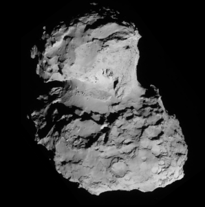
Here a picture of all current images. I annotated some features I think I identified. Maybe I totally wrong, but this comet is really a strange one...
green: B means body, H means head
A: Deep black crater
B: crater
C: Line of bolders on the neck ("necklace")
D: tongue like feature
E: depression
F: Flat field with one side steep slope (cirque-like?)
G: elongated flat field
H: Crater field
I: Flat field
J: Pan cake like feature / crater
K: winding wall
L: great wall with fractures
M: Crater
N: tower montain
P: Deep Crater
O: Bay like feature
Hi MoreInput,
This is an amazing achievement; I believe it can truly help others (like me) keep track of the different features.
However, I think that the features A, E and P are one and the same, just under different perspectives and illumination condition.
BTW, my favorite feature is N, but there are two of them.
Keep up the good work
Gerald
Aug 19 2014, 05:11 PM
QUOTE (wildespace @ Aug 16 2014, 09:54 AM)
I have seen members here mention generating synthetic "in-between" frames from two images, so this is a callout for someone to hopefully generate a bunch of frames between the two fantastic OSIRIS images that made up that 3D view:
http://blogs.esa.int/rosetta/2014/08/14/comet-67pc-g-in-3d/The generated frames could be used to create a more "comfortable" anaglyph, or even an animation of the comet's rotation.
That's the result of a few days of programming and test running a frame interpolation algorithm, to get a very draft of what you suggested, at least:

There are still loads of issues, and about as many ideas to resolve them. But that takes more time; I've posted this draft, because I'm not sure, whether/when I can spend the necessary time. Hopefully it provides some 3D perception, even at this early state.
The apparent center of the rotation in this gif isn't identical with the rotation axis of the comet; there is an additional translational motion, at least.
MoreInput
Aug 19 2014, 07:44 PM
QUOTE (pablogm1024 @ Aug 19 2014, 02:26 PM)
However, I think that the features A, E and P are one and the same, just under different perspectives and illumination condition.
I made a new overview with 2 new pics. And changed E and P to A.

A: Deep black crater
B: crater
C: Line of bolders on the neck ("necklace")
D: tongue like feature
F: Flat field with one side steep slope (cirque-like?)
G: elongated flat field
H: Crater field
I: Flat field
J: Pan cake like feature / crater
K: winding wall
L: great wall with fractures
M: Crater
N: tower mountain
O: Bay like feature
Q: Crater
Don1
Aug 20 2014, 07:42 AM
Looking at these wonderful pictures, I'm wondering if the lander is going to be able to sample the primitive material that the mission is looking for. Much of the surface looks rather young and dust covered.
The other thing struck me was the layering. Then I remembered that hailstones also form by accretion, and that they are often layered. If those layers are real, they could be a signature of the accretion process which built the comet. Or perhaps the comet was part of a larger body that broke apart. Or perhaps the layers are related to multiple cycles of heating and cooling as the comet circles the sun.
Selecting a landing site looks like a very difficult task. Perhaps the mission will delay the landing until they understand the surface processes better?
bobik
Aug 20 2014, 11:04 AM
QUOTE (MoreInput @ Aug 19 2014, 08:44 PM)
I made a new overview with 2 new pics. ...
Craters B and M are one and the same, and also F and Q.
machi
Aug 20 2014, 12:34 PM
Yes, F and Q is the same feature and BTW, I recommend informal name "
Amphitheatre" or "amphitheatron" because it looks exactly as one of these ancient
Greek theatres.
Gerald
Aug 20 2014, 03:16 PM
For completeness, here 86 NavCam images of the
August 6 animated gif as tiles:

marsbug
Aug 20 2014, 03:59 PM
QUOTE (MoreInput @ Aug 19 2014, 08:44 PM)
A: Deep black crater
B: crater
C: Line of bolders on the neck ("necklace")
D: tongue like feature
F: Flat field with one side steep slope (cirque-like?)
G: elongated flat field
H: Crater field
I: Flat field
J: Pan cake like feature / crater
K: winding wall
L: great wall with fractures
M: Crater
N: tower mountain
O: Bay like feature
Q: Crater
Look at the 'necklace' (feature C) in the leftmost and second from bottom image. The image is presented the other way around here than I have seen it before (I know it's not a new image) and while I know that a low Sun angle will be exaggerating things to a degree, I'm struck again by how otherworldy looking those boulders are.
Y Bar Ranch
Aug 20 2014, 05:27 PM
Being an astronaut on a spacewalk around this thing would be absolutely mind-blowing. I keep looking at the photos and imagining where I would go on the surface next, what materials are available I could use for consumables and buildables, etc. I envy the ones that will eventually get to do it.
Good luck with the lander!
MoreInput
Aug 20 2014, 09:58 PM
I update the overview picture with your corrections, and assigned some more features.
See here:
https://drive.google.com/file/d/0B_Dew4M2xF...dit?usp=sharingA: Deep black crater
B: crater
C: Line of bolders on the neck ("necklace")
D: tongue of the dragon rubber duck
F: Amphitheatre
G: elongated flat field
H: Crater field (H1/H2)
I: Flat field
J: Pan cake like feature / crater
K: winding wall
L: great wall with fractures
M: -/-
N: tower mountain
O: Bay like feature
Q: Crater with some rubble in it.
R: Cheek of the dragon rubber duck
S: Big hole in the neck of the dragon rubber duck
wildespace
Aug 21 2014, 09:32 AM
QUOTE (Y Bar Ranch @ Aug 20 2014, 06:27 PM)
Being an astronaut on a spacewalk around this thing would be absolutely mind-blowing. I keep looking at the photos and imagining where I would go on the surface next, what materials are available I could use for consumables and buildables, etc. I envy the ones that will eventually get to do it.
Good luck with the lander!
I don't think you could walk (or even hop around) on this thing, due to its almost non-existent gravity. Pushing off the surface gently would keep you airborne (or, rather, vacuum-borne) for minutes, and a sufficiently strong jump might give you escape velocity.
I often wonder how manned surface exploration of such objects as comets and asteroids could be accomplished (would it even be safe for an astronaut on the surface of a comet?) Would they have to cling to some sort of extendable bars or handrails, and pretty much push themselves around using their arms, like they do during an ISS spacewalk?
(Oops, I hope I didn't break the forum rules by bringing up manned space exploration)
Astro0
Aug 21 2014, 10:09 AM
ADMIN NOTE: Two recent posts skirting close to the Forum rules on human spaceflight. Don't refer to it if you know you shouldn't refer to it. Thanks folks.
Gerald
Aug 21 2014, 01:29 PM
Details about landing site selection, including schedule, via
this summarizing blog.
Preferred landing site will be near the equator to get a good day/night balance.
Edit:
First mass determination: 1e13 kg +/- 10%.
That's about three times the previous estimate. The
escape velocity should therefore be near 0.82 m/s at a distance of 2 km from a point of the same mass.
The velocity due to rotation (12.4h / 360°) at the same distance is about 0.28 m/s. Hence we get a comfortable net attraction.
Y Bar Ranch
Aug 22 2014, 05:20 PM
QUOTE (wildespace @ Aug 21 2014, 04:32 AM)
I often wonder how (un)manned surface exploration of such objects as comets and asteroids could be accomplished
The gravity is so light, that you'd just about need thrusters to push you against the surface vice pull away. I'm thinking a broad net laid onto the structure that the probe could then crawl along to move from point to point. It'd work for just about any topology lying underneath.
I wish Rosetta had one of Curiosity's laser blasters for sampling over the surface.
MoreInput
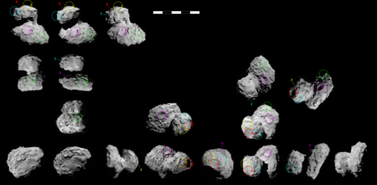
Aug 24 2014, 09:24 PM
From top
-
From side and bottom
belleraphon1
Aug 25 2014, 01:11 PM
Rosetta: Landing site search narrows - just posted on ESA blog
http://www.esa.int/Our_Activities/Space_Sc..._search_narrowsCraig
Gerald
Aug 25 2014, 02:53 PM
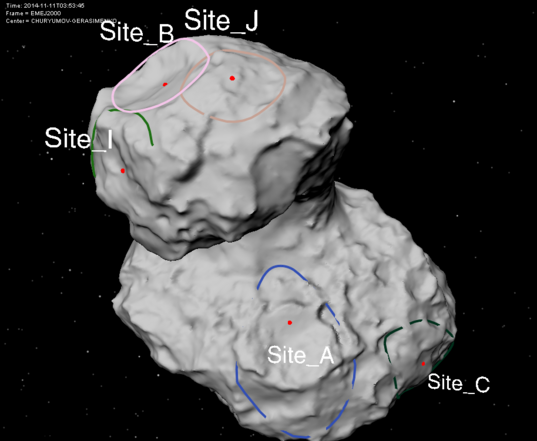
Philae candidate landing sites, synopsis:

charborob
Aug 25 2014, 05:19 PM
Landing site A would probably have the most spectacular views: towards the "Neck" and part of the "Head".
Y Bar Ranch
Aug 25 2014, 06:10 PM
QUOTE (charborob @ Aug 25 2014, 01:19 PM)
Landing site A would probably have the most spectacular views: towards the "Neck" and part of the "Head".
I was wondering how much of an upward look the cameras on board have. Couldn't find out exactly.
charborob
Aug 25 2014, 07:54 PM
QUOTE (Y Bar Ranch @ Aug 25 2014, 02:10 PM)
I was wondering how much of an upward look the cameras on board have. Couldn't find out exactly.
Some discussion of this topic happened around posts 62-64 of this thread. Here is a
link to a YouTube video.
fredk
Aug 25 2014, 07:58 PM
Each CIVA-P camera on Philae has a 60 degree fov. Most are tilted down by 15 degrees, but the stereo pair by 25 degrees. Of course the view will depend on the tilt of the lander once down.
elakdawalla
Aug 25 2014, 08:05 PM
Something I put together for a post tomorrow -- trying to look at the sites as seen in every NavCam image. Not totally sure about my identification of sites I and J in several places; there aren't very good landmarks for those.
 Here is an unlabeled version.
Also, here's another view on the sites mapped on a shape model
posted to the CNES website.
machi
Aug 25 2014, 08:52 PM
QUOTE (Y Bar Ranch @ Aug 25 2014, 08:10 PM)
I was wondering how much of an upward look the cameras on board have. Couldn't find out exactly.
CIVA can theoretically image features up to 18.5 degrees above horizontal plane which is defined by three points where landing gear touches the surface.
Lower limit is 48.5 degrees. Nominal limits for imaging are +15/-45° or +5/-55° (for stereo camera).
Slight (+/-3.5°) extension is possible by usage of tilting mechanism of lander himself but I don't suppose that this will be case in first scientific sequence (FSS, ~65 hours).
lunaitesrock
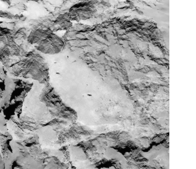
Aug 25 2014, 10:56 PM
I'm not sure what to make of the straitions in landing site A. They seem to be everywhere, especially in the cropped image below. The spacing is close to the same.
vjkane
Aug 26 2014, 12:41 AM
QUOTE (Gerald @ Aug 25 2014, 06:53 AM)
Philae candidate landing sites, synopsis:
Site A gets my vote for the same reason. Let's hope the scientific and engineering analysis comes out to the same conclusion
nprev
Aug 26 2014, 12:49 AM
Pure speculation: The striations are artifacts of the comet's accretion in a primarily gaseous/aerosol-rich, warm primordial cloud. Perhaps the regular spacing is due to the thermal properties of the material: once a uniform layer cooled & solidified, a new layer began to accrete.
On the pessimistic side, could they be image processing artifacts of some sort?
In any case, fascinating as always to see the unknown slowly revealed.

JohnVV
Aug 26 2014, 01:49 AM
The striations at "A" look to be more like "land slide " groves
put it this way
The whole body is basically one BIG glacier ( with rocks )
as some of it slides the harder rocky bits will carve out grooves
http://en.wikipedia.org/wiki/Glacial_striation
SteveM
Aug 26 2014, 08:53 AM
QUOTE (JohnVV @ Aug 25 2014, 08:49 PM)
The whole body is basically one BIG glacier ( with rocks )
as some of it slides the harder rocky bits will carve out grooves
Unlikely. A major factor in glacial striations is the weight (not the mass) of the glacier. On a comet gravity and weight are insufficient for a "glacier" to carve out grooves in rock.
Steve M
SpaceScout
Aug 26 2014, 11:39 AM
QUOTE (SteveM @ Aug 26 2014, 10:53 AM)
On a comet gravity and weight are insufficient for a "glacier" to carve out grooves in rock.
To this I would add that "landslide"/mass movement tends to move material to a lower gravitationally potential. The identification of mass wasting features is intuitive on large spherical bodies, e.g., on Mars a topographically lower material has a gravitationally lower potential. On this comet, however, one first needs to have an idea of the gravity field. A local topographic low does not necessarily have a lower gravitational potential.
So I would say that mass wasting identification can be tricky on this comet.
Striations might have a primordial origin or be formed by shock during impact on a former parent body. A plane analysis of the striations and a plot of the planes's pole would help to elucidate this.
Cheers
Gerald
Aug 26 2014, 01:36 PM
QUOTE (elakdawalla @ Aug 25 2014, 10:05 PM)
Something I put together for a post tomorrow -- trying to look at the sites as seen in every NavCam image. Not totally sure about my identification of sites I and J in several places; there aren't very good landmarks for those.
...
That's my as-independent-as-possible result, based on your unlabled version.
I've been a little less successful with the A's and C's, but my positive identifications are consistent with yours.
Gerald
Aug 26 2014, 03:04 PM
QUOTE (SteveM @ Aug 26 2014, 10:53 AM)
...On a comet gravity and weight are insufficient for a "glacier" to carve out grooves in rock.
I would agree, if we would know, that it's actually solid rock.
But if it's like fresh snow or loosely adhering dust, it's less easy to rule out erosion, e.g. by dust avalanches, as a cause.
If we presume the mean density as between 0.3 and 0.4 of that of water (three times the "old" estimate of 0.1 due to the triple mass), and water ice and silicate dust as main constituents, the mean porosity of the nucleus should be about 70%. This would rule out abundant massive solid rock, instead allow loosely connected non-spherical grains (e.g. flakes or needles), a solid foam (of rock and ice), lots of large caverns, kind of a dry aerogel, or some mix of these structures.
MarsInMyLifetime
Aug 26 2014, 06:26 PM
I am pleased to see site A on the list of candidate landing sites--not just because of the epic view across the valley but because of the adjacent deep hole (almost at north pole) that I suspect looks fresh because it may be one of the most active deep vents. If that is the case, imagine what that might look like as the venting process gets under way again. Also, I suspect that cliffs with piles of rubble at the base may also be active regions of venting, wasting from the face and leaving larger debris as the face recedes. In that regard, most of the proposed sites seem to have some potential active areas directly in view.
Explorer1
Aug 26 2014, 10:20 PM
I suppose it goes without saying that marking a traditional 'landing ellipse' can't be done in narrowing down sites here, does it? Since all the targeting is done by the forces on release from Rosetta and local gravity (which is still unknown), and there is no propulsion on board Philae, it's going to be just as dicey as Huygens was.
djellison
Aug 26 2014, 10:43 PM
QUOTE (Explorer1 @ Aug 26 2014, 03:20 PM)
I suppose it goes without saying that marking a traditional 'landing ellipse' can't be done in narrowing down sites here, does it?
What I'm seeing in ESA's drawings is exactly that - landing ellipses. There is uncertainty in deployment velocity and gravity field ( which is being characterized as we speak )
The Huygens landing site was picked via engineering. The Philae site is being selected via a combination of engineering AND scientific goals and they will be targeting a specific location on the surface to aim for.
marsbug
Aug 27 2014, 06:15 AM
QUOTE (Gerald @ Aug 26 2014, 04:04 PM)
I would agree, if we would know, that it's actually solid rock.
But if it's like fresh snow or loosely adhering dust, it's less easy to rule out erosion, e.g. by dust avalanches, as a cause.
If we presume the mean density as between 0.3 and 0.4 of that of water (three times the "old" estimate of 0.1 due to the triple mass), and water ice and silicate dust as main constituents, the mean porosity of the nucleus should be about 70%. This would rule out abundant massive solid rock, instead allow loosely connected non-spherical grains (e.g. flakes or needles), a solid foam (of rock and ice), lots of large caverns, kind of a dry aerogel, or some mix of these structures.
Depending on how evolved the comet is, and how it has evolved, the porosity may not be uniform. There may be volumes of far higher density, and near voids.
fredk
Aug 27 2014, 02:30 PM
QUOTE (Explorer1 @ Aug 26 2014, 10:20 PM)
a traditional 'landing ellipse' can't be done in narrowing down sites here
Like Doug said there are (quantifiable) velocity and gravity field uncertainties, which have to translate into an uncertainty in landing position. One difference from landing on Mars is that an ellipse may not be a good approximation if those uncertainties are significant relative to the size of the comet. But you could always be conservative and enclose whatever the real shape is with a circumscribed ellipse. (Of course for a large enough region on such an oddly-shaped body it can be hard to
define an ellipse.)
lunaitesrock
Aug 27 2014, 04:09 PM
QUOTE (fredk @ Aug 27 2014, 08:30 AM)
Like Doug said there are (quantifiable) velocity and gravity field uncertainties, which have to translate into an uncertainty in landing position.
Have there been any recent estimates on dimensions of a landing ellipses for any of the 5 sites? I haven't seen any except that they would cover 1 square km, which would include very risky terrain in each landing site as seen in the images. I have a hard time believing that landing ellipses won't eventually cover an area the size of a football field once more gravity field and shape data is obtained from lower orbits.
http://www.esa.int/Our_Activities/Space_Sc..._search_narrowsAlso, will the Active Decent System and flywheel be used to actively aim the lander.... or just maintain orientation and velocity, with targeting to the touchdown point resulting only from the orientation and velocity of Philae at the moment of release from Rosetta? If it's the latter, it will be a heck of a ring toss!
djellison
Aug 27 2014, 04:15 PM
QUOTE (lunaitesrock @ Aug 27 2014, 09:09 AM)
I have a hard time believing that landing ellipses won't eventually cover an area the size of a football field once more gravity field and shape data is obtained from lower orbits.
I have a hard time imagining it will ever be that small. That would require us knowing the location of the orbiter to an accurate barely wider than its own solar panels, and it's distance to the comet similarly accurately, AND the gravity gradiant all the way to the surface in a free-flight that might take anything from 2 to 12 hours. There is so much uncertainty there that a football field is far far too small an area to be thinking of.
QUOTE
Also, will the Active Decent System and flywheel be used to actively aim the lander.... or just maintain orientation and velocity, with targeting to the touchdown point resulting only from the orientation and velocity of Philae at the moment of release from Rosetta? If it's the latter, it will be a heck of a ring toss!
The later. The lander has no means to do course-corrections on the way down. It's only propulsion is to 'stick' it to the surface during touchdown.
elakdawalla
Aug 27 2014, 04:47 PM
Regarding ellipse sizes: this image
from the CNES website shows "ellipses" that are diverse and irregular in shape, so I have been assuming that they are not just one-kilometer dots dropped onto the comet but actually contain some information about the likelihood of Philae landing within them. Notice how elongated the Site A one is, for instance. The open-ended shape of the Site I ellipse is puzzling.
Floyd
Aug 27 2014, 05:01 PM
I thought these were simply five SITES to further evaluate for which is the best SITE. Quite possibly ellipses are just crude SITE markings and not landing ellipses.
climber
Aug 27 2014, 05:47 PM
Emily, on your blog you rise the question regarding site A, whether a polar landing would be better than in a smaller latitude. I red that they want to use the comet rotation velocity to get the touch down as soft as possible. Well, A is still on the list anyway...
Y Bar Ranch
Aug 27 2014, 06:18 PM
QUOTE (elakdawalla @ Aug 27 2014, 12:47 PM)
Regarding ellipse sizes: this image
from the CNES website shows "ellipses" that are diverse and irregular in shape, so I have been assuming that they are not just one-kilometer dots dropped onto the comet but actually contain some information about the likelihood of Philae landing within them. Notice how elongated the Site A one is, for instance. The open-ended shape of the Site I ellipse is puzzling.
Where would the axis of rotation be in this figure?
Phil Stooke
Aug 27 2014, 07:05 PM
I agree with Floyd's post - these should not be considered landing ellipses in the usual sense (envelopes of 50% or 99% dispersion around the target point) but just outlines of candidate areas which might contain the eventual landing site. The detailed studies (doubtless already well under way) of geology, approach paths, topography and gravity will eventually result in real landing ellipses, but we are quite a way from that at the moment.
The rotation pole is in the vicinity of site A.
Phil
Explorer1
Aug 27 2014, 11:28 PM
In some combination of good/bad news, the navcam images are now filling the frame; they are compensating with four at a time, but only a 'corner' is out now:
http://blogs.esa.int/rosetta/2014/08/27/cometwatch-update/
JohnVV
Aug 28 2014, 12:34 AM
QUOTE (Y Bar Ranch @ Aug 27 2014, 01:18 PM)
Where would the axis of rotation be in this figure?
a image ( same as above )
with northpole and 180 Deg Long.

Steve G
Aug 28 2014, 04:33 AM
QUOTE (Explorer1 @ Aug 27 2014, 04:28 PM)
In some combination of good/bad news, the navcam images are now filling the frame; they are compensating with four at a time, but only a 'corner' is out now:
http://blogs.esa.int/rosetta/2014/08/27/cometwatch-update/This comet really reminds me of that 1950's artwork of the moon and asteroids. It's downright creepy. Look at the pointed peaks and has a lot of variety for such a tiny world.
Malmer
Aug 28 2014, 07:34 AM
QUOTE (Explorer1 @ Aug 28 2014, 01:28 AM)
In some combination of good/bad news, the navcam images are now filling the frame; they are compensating with four at a time, but only a 'corner' is out now:
http://blogs.esa.int/rosetta/2014/08/27/cometwatch-update/I have reverse engineered the camera location in relation to the comet for all the nav cam images from the begining of the encounter up until today.
I'm planning on doing it for all the images they release. (working on a shapemodel)
This would help when stitching images taken at slightly different times...
Is this archive showing all publicly available images?
http://www.esa.int/spaceinimages/Missions/.../(class)/image)
Malmer
Aug 28 2014, 09:04 AM
Click to view attachmentOne curious thing that I noticed is that ALL the navcam images released so far are clustered within one hemisphere of the comet.
Hungry4info
Aug 28 2014, 11:23 AM
The rotation axis is highly inclined like Uranus. Right now, one of the comet's poles are facing the sun, and the southern hemisphere is mostly in "night."
So, as far as being able to see things is concerned, it's only worth seeing the illuminated, northern hemisphere.
This is a "lo-fi" version of our main content. To view the full version with more information, formatting and images, please
click here.