It seems about the right time to start a new thread as we have now turned East to Endeavour.
Hope no one minds...
Full Version: Southward from San Antonio to the Next Waypoint
It's ok to move to a new thread but it should not be constrained by that artificial waypoint I created here. There's no ground feature at that point.
I would propose to keep this thead until the next science stop.
I would propose to keep this thead until the next science stop.
Based on James' latest ripple hazard map, we need to throw a party of some kind between here and that dogleg in the route to celebrate the end of the hazardous dunes. Let's hope we see a whole lot more 200 meter drives from here on out.
I could be wrong, but I don't see them going back to 200 m drives ever again, even when Oppy hits nice flat tarmac. I thought they went to shorter drives for the sake of wheel longevity. I would be happy with 100 m drives, and a complete absence of attention-diverting cobbles between here and Endeavour.
Yeah, I don't think we'll see anything much over 100m
Not only that, but if IIRC at about that dogleg, Oppy will be as far from Duck Bay as she was at Eagle Crater!
QUOTE (ElkGroveDan @ Apr 2 2010, 07:09 PM) 
pple hazard map[/url], we need to throw a party of some kind between here and that dogleg in the route to celebrate the end of the hazardous dunes.
Not only that, but if IIRC at about that dogleg, Oppy will be as far from Duck Bay as she was at Eagle Crater!
Does the lack of ripples in the green region imply a wind-sheltered area? If so, Oppy might be deprived of those beneficent Spring gusts to clean the accumulated dust off the Solar panels. In that case, it might be advisable to make haste in the traversal to Endeavour (balancing the power risk against the mobility risk).
Not necessarily. As I recall Oppy's first cleaning events occurred back near Endurance. As I recall it was shortly after emerging from the crater but still on the nice clean tarmac up there.
I think this new start to the drive from Twin Craters is going to be a long one without a stop to investigate
anything. I see nothing interesting for a while unless they spot something. I do hope we go 1 or 2 KM this time
before we do another science stop???
I do have one question: Is Stu a Comedian
anything. I see nothing interesting for a while unless they spot something. I do hope we go 1 or 2 KM this time
before we do another science stop???
I do have one question: Is Stu a Comedian
It is indeed kind of tempting to think that we're in "nothing to see here, move along" mode by now. Looks like transit time-wise we're probably still at least an Earth year away from the outskirts of Endeavour, though, and there's got to be a balance between science return during that period vs. the admittedly very exciting possibility of examining phyllosilicates at the end of this road.
Not an easy set of calls to make (it'll be an ongoing process). It's incumbent upon the MER team to make every day of Oppy's mission as scientifically productive as possible, and it's by no means guaranteed that she'll survive to reach Endeavour. Wonder if they're using any sort of systems optimization models to aid their decision making.
Not an easy set of calls to make (it'll be an ongoing process). It's incumbent upon the MER team to make every day of Oppy's mission as scientifically productive as possible, and it's by no means guaranteed that she'll survive to reach Endeavour. Wonder if they're using any sort of systems optimization models to aid their decision making.
QUOTE (Bobby @ Apr 2 2010, 09:57 PM)
I do have one question: Is Stu a Comedian
Er...?

I think what's happened at San Antonio/Twins is a sign that it'll take a lot now for the team to decide on a long science stop. The Black Cat rock wasn't deemed worth a closer look. Perhaps they decided it was probably another iron meteorite and since we've studied several now, it wouldn't add much to study another.
On the other hand, I'm not sure about the exact timing of the 2199 drive away from San Antonio. Was that drive sequenced before or after the first navcams showing Black Cat came down? Could we be in another Block Island situation here?
Once and if the surroundings change significantly from what we've been seeing at Meridiani (perhaps roughly halfway to Endeavour??), then I could see more science stops to study the new stuff.
Concepción was interesting enough that we could have "eaten the lotus" there and stayed a long time. However we had our Odysseus (Squyres?) to force us back on to the path to Ithaca (as Rui used to call Endeavour). It will be difficult for any other potential stop to match Concepción in interest.
QUOTE (marsophile @ Apr 2 2010, 11:40 PM)
...It will be difficult for any other potential stop to match Concepción in interest.
Don't bet on that marsophile, we're on Mars...
QUOTE (marsophile @ Apr 2 2010, 10:34 PM)
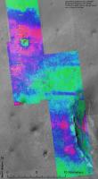
Does the lack of ripples in the green region imply a wind-sheltered area?
Or the opposite maybe? I would like to see that topographic picture provided by tim53 overlayed on James' terrain analysis map; I have the impression that the "green" area fits more or less with the downslope part of the route and we may have a direct-hit from the wind there.
On the other topic, and speaking of science stops, I think there have been two reasons for those: the first one has been already addressed here but the second is the periodic need to put the wheels to rest due to high currents. Given that the rover is currently power limited due to the winter so the drives are shorter and with recharging sols planned from time to time, we may have the luck to avoid those "technical stops" until the winter is over.
My 2c.
So even if we find the ideal terrain, like at the landing site, there will still be no 'pre-Purgatory' style drives, correct? Even Oppy is showing her age...
QUOTE (Explorer1 @ Apr 3 2010, 01:33 AM)
So even if we find the ideal terrain, like at the landing site, there will still be no 'pre-Purgatory' style drives, correct? Even Oppy is showing her age...
Correct. Due to the stress on the RF wheel and also because right now there's not enough power for long drives.
And since we're talking about long drives, I think it's worth to mention Scott's blog on the rovers. Just in case there's anyone here not aware or not following that blog, the narration is currently right on those 'pre-Purgatory' days.
thx for the pointer to Scott's blog 
There's something I'm not sure to understand about the new AEGIS software uploaded recently. I understand that Oppy (& Spirit) can choose to image a rock by herself among other rocks but I'm not sure she can point a Marquette Island type of rock so Mission control could be aware she "saw" something (even during a sol drive) and re-scheduled following sol.
Somebody get an answer to this?
From A.J.S Rayl monthly report:
"Now, Opportunity can use AEGIS at stop points along a single sol's drive, or at the end of the drive, to identify and examine targets of interest that might otherwise be missed"
Somebody get an answer to this?
From A.J.S Rayl monthly report:
"Now, Opportunity can use AEGIS at stop points along a single sol's drive, or at the end of the drive, to identify and examine targets of interest that might otherwise be missed"
I already have it bookmarked, chiefly to wait for his reaction to the Day Everything Changed, if you know what I mean.
QUOTE (climber @ Apr 3 2010, 02:54 PM)
There's something I'm not sure to understand about the new AEGIS software uploaded recently. I understand that Oppy (& Spirit) can choose to image a rock by herself among other rocks but I'm not sure she can point a Marquette Island type of rock so Mission control could be aware she "saw" something (even during a sol drive) and re-scheduled following sol.
Somebody get an answer to this?
From A.J.S Rayl monthly report:
"Now, Opportunity can use AEGIS at stop points along a single sol's drive, or at the end of the drive, to identify and examine targets of interest that might otherwise be missed"
Somebody get an answer to this?
From A.J.S Rayl monthly report:
"Now, Opportunity can use AEGIS at stop points along a single sol's drive, or at the end of the drive, to identify and examine targets of interest that might otherwise be missed"
Here's a nice discussion of Aegis. From the description, I suspect they'd get some information about any autonomously programmed images fairly fast, but it's not clear whether it would be in time for scheduling the next SOL's activities
Steve M
Thanks Steve, even if this doesn't answer my question, it worth reading.
What AEGIS catches on a drive-by is the odd rock that its program finds interesting and takes 12 filter images, and the rover drives on. In the past, the next day scientists would see something in a navcam drive-by image and say, gee, that is an interesting rock, too bad we don't know its spectral characteristics, but it isn't (most of the time) worth going back to to get images. Now they have information on a rock they couldn't target without backtracking. Something like Marquette Island is the exception--where after the images come down, the decision is that it is so important that backtracking is necessary.
Agreed. I look at the AEGIS subroutine as a logical extension of the existing autonomous drive capability. Byte-wise, an interesting rock is no different than a hazard to avoid.
In a way, this gives Oppy a capability that has been lacking: the ability to make observations on the fly without grinding to a halt. A carbon-based geologist, while walking a traverse, will spot an interesting rock or outcrop feature in the distance and will slightly alter course to pass nearby for a closer look or keep going if it's not that unusual, all without losing much time. I've done it hundreds of times, and I'm sure it's still done today.
This leg of the traverse is getting into a different ripple regime, and with a change in elevation, a lower part of the geologic section, so the ability to look sharply around will be critical.
--Bill
QUOTE (Bill Harris @ Apr 3 2010, 05:51 PM)
A carbon-based geologist, while walking a traverse, will spot an interesting rock or outcrop feature in the distance and will slightly alter course to pass nearby for a closer look
... whereas a silicon based geologist just burns a hole through everything in its way and keeps on going.
QUOTE (Tesheiner @ Apr 2 2010, 06:16 PM)
Or the opposite maybe? I would like to see that topographic picture provided by tim53 overlayed on James' terrain analysis map; I have the impression that the "green" area fits more or less with the downslope part of the route and we may have a direct-hit from the wind there. ...
That sounded like an interesting proposal to me, so here it is...Tim's topographic contours on top of James's ripple map. I was not able to perfectly register the two maps through any simple combination of rotation and/or scale changes; so this result is my manual, best average registration. It is good enough, however, to show that Eduardo's hunch was correct. Very good questions remain. Is the downslope region devoid of large ripples because the wind is stronger or weaker there? We know most of the ripples don't move in the current wind regime, but perhaps the trend is the same even in the current wind regimen.
Click to view attachment
Looking it at a larger scale, it may be possible that the Endeavour ring, I mean the hills South East of the actual position could deflect the wind it the direction of the "green" area (this would mean that the dominant wind comes from the South East). It could also be the other way around: the eleavtion slowing down a dominant North West wind. Anyway, looking at CosmicRocker rendering, the ring elevation seams to have some effect.
The ripples are changing because of an increase in wind velocity.
When we reached Concepcion we noticed the presence of transverse dunes (ripples), which suggested either an increase in sand availability or an increse in wind velocity. I initially thought of an increase in sand supply since there is a great deal of weathering of the fragmented rock around the fresh crater, but as we traveled southward ("upwind") of the crater, the transverse dunes were still present and by the time we got to the older, weathered San Antonio craters, we also started seeing scalloping of sand on the ripple crests (erosion).
Concepcion was on the crest of a slight topographic high and the surface to San Antionio is essential flat or with a slight southward dip, and from the Tim Parker topo map, we see that the elevations decrease sharply to the south and southeast.
Air moving in a laminar flow at altitude encounters the hillside and since the cross-sectional flow area is decreased, the velocity will increase due to a venturi effect.
You can also see an increase in bare bedrock areas between here and "mini-Endurance", which I had hoped would be an indication of a change in lithology due to a drop in elevation, but, alas, appears to be less sand because of more wind...
Attached is a drawing illustrating the orographic effect, adapted from an earlier topo x-section by fredk.
--Bill
Thank you Bill.
I was talking of a venturi effect due to the Endeavour rim. Is this consistent with your explanation or not necessary?
Thanks
I was talking of a venturi effect due to the Endeavour rim. Is this consistent with your explanation or not necessary?
Thanks
Should we then, expect a cleaning event on the brae sometime soon?
Is the long trek actually possible without one?
Is the long trek actually possible without one?
It's worth keeping in mind that the upcoming drop down to Endeavour has a slope of only a percent or so. Meridiani is very flat. I'd be surprized if that gave much venturi effect, though I'm really not sure about this. I could see local features (craters) or large scale features (Endeavour rim) affecting the winds.
QUOTE (fredk @ Apr 3 2010, 05:21 AM)
It was executed some hours ago but I would call it "aborted" or so. The net move was just 1m.
Whups. Haven't had that happen for awhile, right?
Word has it Oppy refused to move because the drive coincided with the last episode of "Wonders of the Solar System"...
 Please don't be a dead wheel, please don't be a dead wheel...
Re: SFJCody'
Ahh fudge there went my whole day. Guess I'm slacking off on the pessimism.
Unless we hear otherwise, I'm going to assume it was just a software glitch.
Ahh fudge there went my whole day.
Guess I'm slacking off on the pessimism. Unless we hear otherwise, I'm going to assume it was just a software glitch.
And this isnt a very interesting place to spend the rest of the mission, at least Spirit had something interesting to look at while stuck.
I asked Scott Maxwell the following question on his blog:
http://marsandme.blogspot.com/
Scott's answer was:
http://marsandme.blogspot.com/
I found Opportunity's rate of progress around SOL 400 amazing. I have heard rumours that Opportunity will soon reach easy driving country again. If so then will we be at Endeavour crater sooner than we all expect?
Scott's answer was:
We will indeed reach a nice flat zone in another kilometer or so. Once we're there, the terrain will again support longer drives, and we're looking into techniques to do those safely with the current hardware.
But what's currently constraining our progress is less the terrain and more the condition of the right front wheel: we're sticking to 70m/sol as a way to keep that wheel healthy, and if in fact we need to continue to do that, it won't matter how benign the terrain is. It wouldn't do us much good to cover 200m/sol for a few weeks, only to kill that wheel.
I should add that just now our progress is further constrained by the lower energy levels we're experiencing as a result of Martian winter's onset, but that will relax after solstice.
So, for now, you should figure that the flat terrain will still have a 70m/sol speed limit. We'd like to raise that limit just as much as you would, though, and we certainly will if we can!
QUOTE
the upcoming drop down to Endeavour has a slope of only a percent or so. Meridiani is very flat. I'd be surprized if that gave much venturi effect, though I'm really not sure about this
Exactly. This effect is quite small and manifests itself as very subtle changes in the ripple morphology. Erosional/depositional processes are so gentle and can take hundreds or thousands of years to affect changes.--Bill
> So, for now, you should figure that the flat terrain will still have a 70m/sol speed limit. We'd like to raise that limit just as much as you would, though, and we certainly will if we can!
I can see that speed limit.
Click to view attachment
I can see that speed limit.
Click to view attachment
QUOTE (SFJCody @ Apr 5 2010, 04:06 AM)
Please don't be a dead wheel, please don't be a dead wheel...With Scott's talk of purgatoids lurking about, I'm wondering if we encountered some soft ripple and stopped from slippage. The last turn in place looked a bit... messy?
It would be nice to see the latest hazcams but as often seems to happen when something unusual occurs, exploratorium is late in delivering the goods. Coincidence?

As I recall the wheel current issues were somewhat alleviated by reversing driving direction now and then. I wonder if they have considered a pirouette kind of driving routine for long distances. The rover would drive 40 meters or so, stop and turn 180 degrees and resume driving in the other direction. While that might be hazardous around purgatoids, out on the flat plains it might make sense.
QUOTE (ElkGroveDan @ Apr 5 2010, 03:47 PM)
As I recall the wheel current issues were somewhat alleviated by reversing driving direction now and then.
I think rest was found to be more important than reversing direction. Check out this post from Paolo.Paolo's posts are a goldmine of information. In this one he mentions that RF currents drop substantially on bedrock. Perhaps we can expect some drop in current on flat tarmac compared with the current ripples? I'm thinking along the lines of Spirit's wheel resistance in Troy that was reduced when they did the swimming stroke motions? Of course Spirit's case was much more severe. But perhaps a reason to hope for slightly longer drives on the tarmac.
QUOTE (ElkGroveDan @ Apr 5 2010, 04:47 PM)
I wonder if they have considered a pirouette kind of driving routine for long distances.
AFAIK, this kind of manouver was already executed during the long drives right after leaving Victoria. Once again, Paolo is the source.
The first 50 or 80m of a drive were covered moving backwards in "blind mode" and the remaining part moving forward in autonav.
That image is from the previous drive. On 2202 we perhaps dug into a dune enough to trigger an abort? Here's the F hazcam:
http://qt.exploratorium.edu/mars/opportuni...NVP1211R0M1.JPG
http://qt.exploratorium.edu/mars/opportuni...NVP1211R0M1.JPG
Climber, that's an old picture from about a week ago.
This is the latest fhazcam picture; in any case no visible problem.
Click to view attachment
This is the latest fhazcam picture; in any case no visible problem.
Click to view attachment
Sorry, 1 m drive, then abort, corresponded too much to what I though was the right one, so I didn't double checked.
Thanks for correcting.
Thanks for correcting.
FWIW, the next drive is on sol 2204 i.e. tomorrow.
This is a "lo-fi" version of our main content. To view the full version with more information, formatting and images, please click here.