Full Version: Southward from San Antonio to the Next Waypoint
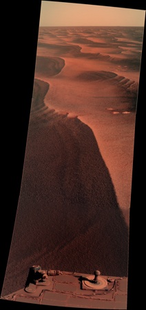
Image was taken after backing away from spot where slip limit was triggered, at start of the drive on sol 2226.
Gah, my bad.
QUOTE (Stu @ May 2 2010, 08:10 AM) 
Worth a few days' rest to investigate, or scoot right past..?
In rockhound parlance, that is one we'd call a leaverite.
In keeping with the recent trend toward geologic puns, it could be called "a pebble without a cause."

QUOTE (Phil Stooke @ May 1 2010, 08:54 PM)
"Geology is important, since without it, the geography would have nothing to sit upon..."
Very good! ...
Very good! ...
That's really quite good. ...nice work, Bill.
As we get closer to Endeavour's rim it seems likely that there ought to be ejecta from the "interesting" rocks on the peak scattered about. These ought to be very distinct, both in terms of appearance and chemistry (phyllosilicates) as compared to the evaporite scattered about the plains. Some of these rocks may have been thrown quite a distance.
From another post I encountered the quote:
"Scott Maxwell: According to the science team member I asked, the phyllosilicates are expected to show up starting 200-500 meters from the rim (hence, starting outside of the wall). That's still another 11-12km from here, so we have a way to go yet! ... "
Due to the random nature of impact ejecta, some of these phyllosilicate rocks will have been tossed quite a bit further than that. Does anyone have some notion as to how these rocks might differ from the evaporite chunks and meteorites already encountered? More likely to be basaltic? Or perhaps another variety of sedimentary rock ostensibly similar to the evaporite? Distinct color? Would they show-up on HiRise imagery?
QUOTE (algorimancer @ May 3 2010, 09:40 AM)
Due to the random nature of impact ejecta, some of these phyllosilicate rocks will have been tossed quite a bit further than that....
As I understand it, the 100s of meters of Meridiani sediments were laid down after Endeavour was formed. So the ejecta is buried deep beneath those layers. The phyllosilicates, if found, will be parts of exposed crater rim. My understanding is of course subject to correction.

Presumably any sizable impacts into the exposed Endeavour rim after the Meridiani sediments were laid down could spread ejecta containing phyllosilicates on top of the Meridiani sediments. There are smaller craters superimposed on Endeavour's rim, but my guess is any ejecta from these would be few and far between this far out.
QUOTE (centsworth_II @ May 3 2010, 11:16 AM)
...ejecta is buried deep beneath those layers.
Actually I was referring to ejecta from more recent impacts into the rim, rather than ejecta from the original impact. The recent ejecta may still be around. Incidentally, I browsed through some imagery of Endeavour's rim and it looks like the phillosilicate-rich rock near the peaks is very light-toned, perhaps even yellowish. It might be difficult to tell from the evaporite bedrock; perhaps it is even sedimentary.
QUOTE (algorimancer @ May 3 2010, 11:42 AM)
Actually I was referring to ejecta from more recent impacts into the rim...
I wonder how resistant that ejecta would be to erosion. I'm guessing that there are no "fresh craters" on Endeavour's rim.
From sky to the rover, on Sol 2229

Lovely pic, Ant.
Cute how the ball on top of the sundial looks like a miniature Mars globe...
Cute how the ball on top of the sundial looks like a miniature Mars globe...
QUOTE (Ant103 @ May 3 2010, 10:43 PM)
From sky to the rover, on Sol 2229
An artistic shot, really. It was named "Moment in Time".
What is the story behind the "L1" (clear filter/no filter) Pancam sequence today (Sol 2223)? Given the characteristics of the silicon CCD, the color sensitivity ought to be broadband in the red-IR range. I can't hardly remember the last time we used the L1 Pancam filter.
--Bill
--Bill
Spectacular pic, Ant!
Oddly reminds me of Viking shots, probably because of the spacecraft in the foreground.
Oddly reminds me of Viking shots, probably because of the spacecraft in the foreground.
L1 pans are often done in conjunction with orbital observations for albedo obs.
QUOTE (Bill Harris @ May 4 2010, 02:30 AM)
What is the story behind the "L1" (clear filter/no filter) Pancam sequence today (Sol 2223)?
We see L1 horizon sequences from time to time. Here's a recent example:
http://marsrovers.jpl.nasa.gov/gallery/all...nity_p2199.html
As I recall, they're called albedo pans and they're matched with orbiter imagery, though someone can correct me if I'm wrong.
What's odd is that they're always downsampled to 512 by 512. This is the only one I recall at full resolution.
Edit - like Doug says.
In Ants "Moment in Time" image, I have wondered for a long time if anyone has noticed that the white ring (on the sundial) has lifted up over the coarse of the mission. What process would cause this?
Interesting. Just a guess but perhaps it's being caused by deterioration of an adhesive (and I have no idea if any kind of adhesives were even used on the MERs).
Agreed, I'd guess the thermal cycling over 6 years caused it to loosen and/or warp.
Not to edge over to kookiness, but does anyone have ideas/theories about the dark blue "stain" on the deck to the left-rear (as viewed) of the sundial? I've noticed it for a while, but haven't figured it out.
--Bill
Not to edge over to kookiness, but does anyone have ideas/theories about the dark blue "stain" on the deck to the left-rear (as viewed) of the sundial?
I've noticed it for a while, but haven't figured it out.--Bill
QUOTE (Bill Harris @ May 4 2010, 10:14 AM)
... dark blue "stain" on the deck ...
Weird indeed, seems to creep up onto the solar cell... soil? ...from Victoria?
The dark blue "stain" looks to me to be just dark soil that has built up, this has been seen before on the solar panels. The white ring warping up is pretty interesting, also to note this has not happened to Spirit's sundial. It would be interesting to assemble a time-lapse movie of Oppys sundial over the coarse of the mission.
About Bill's dark "stain" near the sundial, if it were dust deposition I'd think it should be similar colour to the rest of the dust on the rover, ie light Mars coloured. My guess is that it's an area where the dust has been removed. Wind blowing past the sundial could set up eddy currents on the lee side, which might scour the dust from that area.
It is mysterious. My take, for the time being, is that is is an aeolian phenomemon. Either a wind eddy keeping the solar panel clean or "density sorting" by the wind-- a collection of dust with a higher density. It has an indigo color in IRB, characteristic of a basaltic material, which is denser than the ocher evaporitic material.
Just curious...
--Bill
Just curious...
--Bill
Yes it is. I wonder how that chunk of rock fell off onto it's side. Then I look around the outcrop and wonder if their isn't a softer layer in it where "debonding" occurs. I see a strata eroded into the rock.
Almost seems that you could take a spade, jam it under the slab, lever and remove...
Here is hoping that this trend for changes in the geology will keep up. Recently we saw that nice, rounded evaporite boulder (named Newfoundland?) sitting by itself. Now we see a bedrock slab that has apparently moved. If this were an ancient buried crater being exhumed we would see signs of arc-shaped rim remnants in the orbital images, as we did at Erebus and the unnamed crater we skirted between Shelter Island and Marquette. One thing that can cause collapse is solutioning (solution cavities) caused by groundwater. Given the Anatolia features, vugs seen at (?? oh my, that crater we landed in), and possible fracture fill in several locations it is clear that this is a karst landscape. Now that we are getting near to the slope, the potential surface for the groundwater can create more movement.
We'll see. The journey continues.
--Bill
We'll see. The journey continues.
--Bill
QUOTE (Bill Harris @ May 5 2010, 02:05 PM)
(?? oh my, that crater we landed in)
Eagle
 I had the same thing happen to me last week as I was trying to remember Erebus.
-- Pertinax
Eagle, one of those "E"-words (Endurance, Endeavour), and a good old hole-in-one golf term, too.
Thanks...
--Bill
Thanks...
--Bill
Yes, knowing it start with a E is of no help actually!
A question to Bill: I thought you expected a dramatic change only when we would start going down to Endeavour. I have the feeling that you start to may be already "feel" the rim where we are now? Am I right? If so, is it due to the ground trust (which is 2 orders or magnitude (IIRC) better than HiRise) or a global analyse?
Thanks.
Speaking of geologic changes, I've been wondering about the phyllosilicates observed in and near Endeavour's rim. The phyllosilicate group contains a lot of different minerals, not all of which are clay minerals. I was going to ask if anyone here had more specific information about which phyllosilicate minerals had been detected from orbit. Instead, I managed to find a paper with those and many other interesting details. It contains imagery showing many of the CRISM identified anomalies on and near the rim segments Opportunity is heading for.
This is a very interesting paper for anyone interested in this subject. It contains stratigraphic and structural information about the relationships between the Meridiani sulfate sediments and Endeavour's rim rocks. It says that ferro-magnesian smectite clay minerals are indicated by the spectra of the rim, and polyhydrated sulfates are seen in the plains to some distance west of the rim.
The "Discussion and Conclusion" section makes it clear just how important a role Opportunity can play in elucidating the early story of water on Mars...the time before the water became acidic...the transition between the end of the formation of such clay minerals and the beginning of the era of acid sulfate deposition.
Phyllosilicates and sulfates at Endeavour Crater, Meridiani Planum, Mars; J. J. Wray, E. Z. Noe Dobrea, R. E. Arvidson, S. M. Wiseman, S. W. Squyres,A. S. McEwen, J. F. Mustard, and S. L. Murchie November 2009
Hey, that's really great. Thanks for posting.
Good reference, CR. I neeed to dig more and keep up on the current literature.
Climber-- In geology, you notice subtle changes. Although I talk like it will be sudden and profound, the changes will be very small and happen slowly. We will see more change in the next year than we have seen in the previous six years. This will be primarily because we are going downhill topographically and therefore downward in the geologic column.
The best illustration I've seen comes from the paper that Cosmic Rocker just mentioned:
http://www.planetary.brown.edu/pdfs/3954.pdf
Attached is a clip from Figure 1 of that paper, showing a topgraphic and geologic cross-section of the traverse from Eagle to Endeavour. Note the horizintal layers with hematite, horizontal layers with hydration signatures and phyllosilicale-bearing layers. All of which indicate different depositional environments. Or climates.
Currently, Oppy is at the 10-11 Km distance mark.
--Bill
Thanks Bill.
I also noticed in the paper that Mini-Tes will get readings.
Is it still usable or is there still too much dust on it? Then, I can't remember how far from Columbia Hills it was used on Spirit so, does somebody knows how far from Endeavour it could be used and get decent readings?
I also noticed in the paper that Mini-Tes will get readings.
Is it still usable or is there still too much dust on it? Then, I can't remember how far from Columbia Hills it was used on Spirit so, does somebody knows how far from Endeavour it could be used and get decent readings?
In a couple of messages scattered between here and the "Distant Vistas" thread I've mentioned the geology, the lithology (rock types) and the topography and it how it all relates to what we're seeing here. In today's Planetary Society Blog, Emily discusses geomorphology ("how the geology got the way it is") with reference to another area, the Nili Fossae region near Syrtis Major. Well worth the read.
http://www.planetary.org/blog/article/00002472/
--Bill
http://www.planetary.org/blog/article/00002472/
--Bill
QUOTE (Tesheiner @ May 4 2010, 12:28 AM)
An artistic shot, really. It was named "Moment in Time".
Interesting story behind this...
Edit - more details here.
Way to go. Emily!
Got a HiWish image and had my finger in the pot for an Opportunity color photo, all in the same week! 
Oh my how fun it'd be to enter the "location" field on the entry form for Oppy's image...
I tried 'Meridiani Planum, Mars', got a 'sorry, we couldn't find that location'. What, no Google Mars plug-in?! 
(Pretty sweet week all right, Emily!)
(Pretty sweet week all right, Emily!)
We've heard mention that Oppy might need to stop on a north facing dune since power levels are quite low, and it looks like it's going to happen now. I can't imagine she'd need to park for very long, though.
The title of this thread was a little ahead of itself. From sol 2197 through 2231 we have gone about 400m south and about 100m east. So I guess its SSSE from San Antonio to the next waypoint. 
Not necessarily. The plan may have been (or we thought it was) to turn eastward (as in Tim Parker's map in 2838.pdf), but the route in Figure 1 in the Phyllosilicate paper (3954.pdf) would certainly indicate a southeast heading in that direction. The southwesterm Endeavour rim may be a better target.
--Bill
--Bill
I'm hoping for an eastwards turn soon...
Meanwhile, after the latest drive we seem to have ended up with our rear wheels on the north end of a dune, which has given us a bit of a northward (sun favourable) tilt:
http://qt.exploratorium.edu/mars/opportuni...0M1.JPG?sol2234
Meanwhile, after the latest drive we seem to have ended up with our rear wheels on the north end of a dune, which has given us a bit of a northward (sun favourable) tilt:
http://qt.exploratorium.edu/mars/opportuni...0M1.JPG?sol2234
Bill, that line in the paper is not a route, it's the location of the cross-section.
Phil
Phil
Oh... so it is.
Nevermind.
Nevermind.
QUOTE (fredk @ May 7 2010, 11:12 PM)
Meanwhile, after the latest drive we seem to have ended up with our rear wheels on the north end of a dune, which has given us a bit of a northward (sun favourable) tilt:
http://qt.exploratorium.edu/mars/opportuni...0M1.JPG?sol2234
http://qt.exploratorium.edu/mars/opportuni...0M1.JPG?sol2234
I'm wondering if this place will be a sort of "winter haven", given the limited energy.
I would hope not. With lots of ripples to choose from, perhaps they could make short drives and still find a spot to finish up with a favorable tilt.
Update on the latest drive attempt:
QUOTE
Had to nix today's Oppy drive: modeling tools projected insufficient energy.
urrgh, better safe than sorry!
This is a "lo-fi" version of our main content. To view the full version with more information, formatting and images, please click here.