trev
Jan 14 2005, 06:49 PM
During the entire descent, Huygens will capture and relay to Cassini 1100 images...... so 550 is not bad, i dont know if its the first 550 or last 550 wich may have been lost???....hopefully we still get the full descent...
 http://www.planetary.org/saturn/huygens_mission.html
volcanopele
Jan 14 2005, 06:50 PM
QUOTE (gpurcell @ Jan 14 2005, 11:40 AM)
Ugh. This sounds bad for the DISR images.
How is the data interwoven between the channels? We we lose whole shots, will there be missing patches within shots, or will the image be or lower resolution?
Some panoramas are in Channel A, some are in channel B. So we will have whole panoramas, just half of those planned. At least that's my understanding after the status report telecon.
volcanopele
Jan 14 2005, 06:53 PM
QUOTE (trev @ Jan 14 2005, 11:49 AM)
During the entire descent, Huygens will capture and relay to Cassini 1100 images...... so 550 is not bad, i dont know if its the first 550 or last 550 wich may have been lost???....hopefully we still get the full descent...
http://www.planetary.org/saturn/huygens_mission.html see, look on the bright side. The way I understand it, the panoramas are interwoven, as above, ABABABAB. We may have lost more high altitude panoramas than lower altitude panoramas. But it is not an all-or-nothing proposition.
tedstryk
Jan 14 2005, 07:02 PM
The first pictures of Titan's surface will be released by ESA about 2:45 ET.
BTW, does anyone know the time that the Huygens signal was lost on Earth?
tedstryk
Jan 14 2005, 07:30 PM
Does anyone know how the DISR images are to be connected...e.g, will loosing half the data mean the loss of all data in one direction consistently throughout descent, or will it be more random.
Ted
djellison
Jan 14 2005, 07:31 PM
Is the A-channel totally borked - is itt just a bit screwey and thus potential for recovery
Doug
volcanopele
Jan 14 2005, 07:33 PM
QUOTE (tedstryk @ Jan 14 2005, 12:30 PM)
Does anyone know how the DISR images are to be connected...e.g, will loosing half the data mean the loss of all data in one direction consistently throughout descent, or will it be more random.
Ted
The loss of one channel will mean they will lose entire panoramas, but other panoramas will reamin intact since they are entirely on Channel B.
tedstryk
Jan 14 2005, 07:36 PM
Yes, but do you mean 360 panoramas or shorter panoramas that will be assembled into mosaics?
djellison
Jan 14 2005, 07:42 PM
Consider it like MER. As I see it - you'd have lost the Lion King panorama, and the Endureance Pan Point A Panorama, but the Mission Succes Panorama, the first Endurance Panorama and the Burns Cliff panorama are ok
Doug
tedstryk
Jan 14 2005, 08:03 PM
Looks like channels!!!!
Sunspot
Jan 14 2005, 08:05 PM
Bjorn Jonsson
Jan 14 2005, 08:06 PM
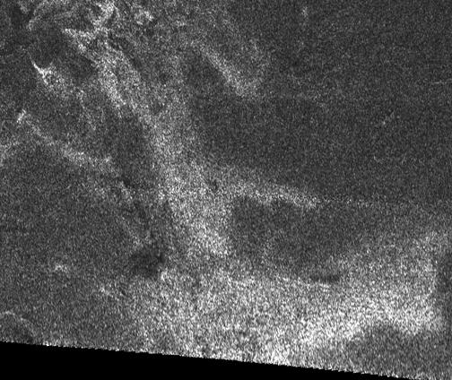
That DISR image I just saw was much sharper than I imagined it would be. The features there were described to look like drainage channels.
volcanopele
Jan 14 2005, 08:07 PM
HOLY CRAP!!!!!
Bjorn Jonsson
Jan 14 2005, 08:08 PM
Can't wait to see more images. WOW !!
pioneer
Jan 14 2005, 08:10 PM
The dark, smooth part on the right looks like a lake of liquid. The squigly lines remind me of a Viking image of Mars showing dried up streams.
David
Jan 14 2005, 08:16 PM
I want to say that that image literally brought tears to my eyes, being so beautiful and so much of what I'd hoped for. Thanks, Huygens!
QUOTE
The dark, smooth part on the right looks like a lake of liquid. The squigly lines remind me of a Viking image of Mars showing dried up streams.
Not sure if we're looking at the same image or not, but if we are, then shouldn't those channels (and they can hardly be anything else) be flowing
into the "lake" and not
away from it, if it actually were a lake? Maybe it's more like a glacier?
djellison
Jan 14 2005, 08:21 PM
I was the same. It sent shivers down my spine - it was just beyond anything i could possiblt have imagined.
Doug
volcanopele
Jan 14 2005, 08:25 PM
QUOTE (David @ Jan 14 2005, 01:16 PM)
I want to say that that image literally brought tears to my eyes, being so beautiful and so much of what I'd hoped for. Thanks, Huygens!
QUOTE
The dark, smooth part on the right looks like a lake of liquid. The squigly lines remind me of a Viking image of Mars showing dried up streams.
Not sure if we're looking at the same image or not, but if we are, then shouldn't those channels (and they can hardly be anything else) be flowing
into the "lake" and not
away from it, if it actually were a lake? Maybe it's more like a glacier?
looks like a delta to me
volcanopele
Jan 14 2005, 08:27 PM
other possibilities that are coming up are volcanic outflow channels and rain drainage from the last equinox rainy season
Roby72
Jan 14 2005, 08:28 PM
Pando
Jan 14 2005, 08:29 PM
djellison
Jan 14 2005, 08:34 PM
Looks like the bastard love child of Venus and Mars

doug
Baltic
Jan 14 2005, 08:36 PM
A shoreline? Out there? Okay, it's bitterly cold and not water at all ... but I love the sea and I love lakes, too. I hope *so* this turns out to be a liquid! I'm so thrilled, guys!

Not even Europa has a shoreline!

Tom
djellison
Jan 14 2005, 08:38 PM
From John Zarniki (sorry about the spelling)
3 hrs 27 mins and 26 second data in all
1hr 10 minues of data from the surface of titan
Doug
SFJCody
Jan 14 2005, 08:38 PM
Wow, look how rounded those cobbles are! Maybe the hour+ of surface images could be stacked to improve the resolution.
djellison
Jan 14 2005, 08:39 PM
Yeah - a thick atmosphere might give a slight bit of motion to the image - perhaps super -res imaging on it
Doug
David
Jan 14 2005, 08:39 PM
QUOTE
looks like a delta to me
I can't believe that. No delta on earth has outflow channels that get
smaller as you go downstream.
QUOTE
other possibilities that are coming up are volcanic outflow channels
Maybe, but I find it hard to see volcanic outflow coming off what looks like multiple watersheds. This looks like a typical earthly drainage pattern.
QUOTE
and rain drainage from the last equinox rainy season

We know enough about Titan now to know if it has rainy seasons? You're pulling my leg, right?
That surface picture -- well, I was wrong about the oozy tar pits.
At least, we didn't land in any. But what's that off on the horizon? Does it look curved because of (1) the optics, (2) because there's some kind of humped formation out there? Oh for a rover!!!
Bill Harris
Jan 14 2005, 08:43 PM
QUOTE
OMG, that is a classic fourth-order dendritic drainage pattern. That is a river. Idea of the scale of this pic?
--Bill
David
Jan 14 2005, 08:43 PM
QUOTE (Baltic @ Jan 14 2005, 08:36 PM)
A shoreline? Out there? Okay, it's bitterly cold and not water at all ... but I love the sea and I love lakes, too. I hope *so* this turns out to be a liquid! I'm so thrilled, guys!
Not even Europa has a shoreline!
I would dearly, dearly love for that to be a shoreline and a lake or sea -- just so you know where my biases lie -- but unfortunately I think I see a crater or two in the "lake". If I'm right about the drainage, then the "lake" has to be significantly
higher than the surrounding terrain. Could it be, say, the lobe of a (cryo-?)volcanic outflow?
tedstryk
Jan 14 2005, 08:43 PM
It sure reminds me of the Venera 9 pan. Superficial, but it looks like it. As for the channels...that depends...might this be some sort of a murky delta? That would explain the large channels breaking into a bunch of small ones. The features in the lake could be craters on the lakebed poking through the surface, or, if they are not craters, they may be islands or sand/mud bars,
SFJCody
Jan 14 2005, 08:47 PM
David
Jan 14 2005, 08:50 PM
QUOTE (tedstryk @ Jan 14 2005, 08:43 PM)
It sure reminds me of the Venera 9 pan. Superficial, but it looks like it.
I think to some extent that has to do with looking out on a kind of bleak overcast landscape on both Venus and Titan. But the details are quite different; on Venus, we had a wholly rocky surface split into sharp-edged slabs; here we're looking at a "sandy" plain (who knows what that stuff is actually) strewn with rounded boulders. It's more reminiscent of Mars, though the rocks are not shaped like the usual volcanic and impact debris we see on the Martian plains.
Roby72
Jan 14 2005, 08:53 PM
Cody, what did you mean with triplets ? Image mosaics ? where could it found ?
SFJCody
Jan 14 2005, 08:54 PM
Click on the link above.
azstrummer
Jan 14 2005, 08:55 PM
Wow, quite a hazy trip down it appears. Some of those views in the triplets could easily be delta areas on the Earth.
David
Jan 14 2005, 08:55 PM
QUOTE (SFJCody @ Jan 14 2005, 08:47 PM)
Is number 671, top, a view from low altitude looking across the channels toward the horizon? That's the impression I get. If so, I should like to see it with a bit of enhancement -- it should be very interesting.
QUOTE
Cody, what did you mean with triplets ? Image mosaics ? where could it found ?
Just click on the word "Triplets".
YesRushGen
Jan 14 2005, 08:59 PM
HOLY COW.
I'm completely speechless with the few images we have so far. We need a longer duration mission to Titan. NOW!!!
I'm guessing it will not take the scientists very long to start lobbying for one.
Anyhow, once these images are processed, and Huygens' position is determined accurately, will we be able to Have Cassini reimage the landing area in high resolution so that we can correlate ground truth with Cassini's observations? Doing so would allow better inferences about OTHER areas that Cassini observes.
volcanopele
Jan 14 2005, 09:04 PM
wow, I just got back from looking at those
Certainly fluids had a hand in this terrain and we landed in material best described as creme broule (I know I misspelled that)
David
Jan 14 2005, 09:04 PM
QUOTE (YesRushGen @ Jan 14 2005, 08:59 PM)
HOLY COW.
I'm completely speechless with the few images we have so far. We need a longer duration mission to Titan. NOW!!!
I shan't be satisfied with anything less than a half-dozen orbiters and two or three rovers.

Seriously, it's going to be tough lobbying for another Titan lander though we clearly need one. At the press conference they were saying that they don't expect to see another one in their lifetimes (and those guys aren't
that much older than me!

). This is going to have to be very, very carefully packaged and sold, and unfortunately has to compete with better-funded and flashier programs.
SFJCody
Jan 14 2005, 09:05 PM
Compare these...

[The one in the centre]
tedstryk
Jan 14 2005, 09:12 PM
Two questions....are those compressed versions of the images, and is this the complete Huygens set?
Mongo
Jan 14 2005, 09:19 PM
There are many more photos to come. During the ESA press conference, it was mentioned that they already had received 350 images, partway through transmission from Cassini. The ones released so far are merely the first wave of photos.
djellison
Jan 14 2005, 09:24 PM
I'm just going to go "wtf" for a while
One part of this looks like a a river catchment area starting at a coastline and working inward...

And another part - just a little further down the coast ( we drifted along this costal feature - we have views from both sides of it )
We have amore classical river channel

I will keep saying WTF till we have a follow on misison
Doug
estrand
Jan 14 2005, 09:34 PM
Just playing with brightness/contrast on some of the raw images:
http://img9.exs.cx/img9/4122/titancollage0lb.jpgEric
Fred
Jan 14 2005, 09:34 PM
Go here:
http://www.lpl.arizona.edu/~kholso/jpeg/ to see lots more triplets. Many of them seem to be duplicates, though.
djellison
Jan 14 2005, 09:34 PM
Is it feasable that it landed in a small puddle?

That bottom image looks a lot like a shallow puddle - with something sort of sandy in the bottom and pebbles in it - with a torch held next to it
Doug
M_Welander
Jan 14 2005, 09:35 PM
I find it interesting that we see plenty of smaller impact craters in these images, compared to what appears to be a lack of larger impact craters on a global scale. At the very least, this should help dating the features we see in the images.
Fred
Jan 14 2005, 09:40 PM
QUOTE (M_Welander @ Jan 14 2005, 09:35 PM)
I find it interesting that we see plenty of smaller impact craters in these images, compared to what appears to be a lack of larger impact craters on a global scale. At the very least, this should help dating the features we see in the images.
What look like small craters are aparently image artifacts or dust or something. They are in the same place in each image regardless of where the camera is pointing.
M_Welander
Jan 14 2005, 09:42 PM
You're right, of course. That was stupid of me. I should have noticed that.
David
Jan 14 2005, 09:50 PM
QUOTE (Fred @ Jan 14 2005, 09:40 PM)
What look like small craters are aparently image artifacts or dust or something. They are in the same place in each image regardless of where the camera is pointing.
Right. Well, that detracts from my reasons for supposing that the "lake" was not liquid. I'd still like to see some unambiguous images of the rivers (can I call them that now?) flowing
into the "lake".
And if we have that, I'll be happy as a clam to take the quotation marks off.
This is a "lo-fi" version of our main content. To view the full version with more information, formatting and images, please
click here.