Help - Search - Members - Calendar
Full Version: Post Solar Conjunction/Santorini Study Drive
Unmanned Spaceflight.com > Mars & Missions > Past and Future > MER > Opportunity
Pages: 1, 2, 3, 4, 5, 6, 7, 8, 9, 10, 11
fredk
QUOTE (remcook @ Mar 9 2009, 05:23 PM) *
Maybe the reason they took the funny detour is to get the two craters into a nice shot

My technical-leaning mind suspects something engineering or science related. Perhaps it's some kind of test related to the raised wheel current. Perhaps they've spotted a tasty looking cobble or piece of bedrock, though I can't see anything in the images.
remcook
Note the smiley at the end. I don't think there is a chance they did it for a nice picture. Maybe if the picture is more useful like this...
kenny
Some years ago I happened to find myself strolling along the Lisbon waterfront and came across this inspiring monument to exploration. Even from a distance, I realised what it represented... there are not many sculptures you can say that about. Close up, I found the detail amazing and captivating. I stayed looking at it for quite some time....
jamescanvin
What I find most confusing is that the Resolution mosaic was taken after the drive. It would have been much better taken before the drive when Oppy was much closer to the crater. I'm sure all will become clear in due course.

djellison
Taken before the drive, it wouldn't have had the pretty tracks in it. I wonder if it was one of those 'happy accidents' like the Aviation Week Navcam Mosaic

Doug
fredk
A very tasty morsel has been tossed our way in the latest official route map.

It looks like projected routes, as well as colour coding (yellow) for terrain to avoid? smile.gif
Tesheiner
Speaking about projected/planned routes what I would love to see is the map section right below (south) this one.
ustrax
Porcupine here we go! smile.gif
Tesheiner, by the look of it it appears the turn East won't take too long after...the yellow line takes that direction...
ngunn
QUOTE (fredk @ Mar 11 2009, 04:05 AM) *
the latest official route map


Is it my imagination or are there radial 'splat' patterns (some light, some dark) centered at each of the last few stopping points?
remcook
I assume those are projections of panoramas/images to fit the map.
Tesheiner
Still waiting for image downlink but according to the data from the PCDT Opportunity moved back closer to Resolution; almost at the same spot it was on sol 1820.
Phil Stooke
Splat! Yes, remcook is correct.

Phil
ngunn
QUOTE (remcook @ Mar 11 2009, 10:16 AM) *
projections of panoramas


Thanks. Has this always been done? I don't remember noticing them before.
djellison
I've seen them plenty of times in the past, yes.
RobertEB
One thing I have noticed about Meridiani Planum is that there is little or no regolith. All the craters we see are rimmed by thrusted-up bedrock.

Compare those with the ones we have seen at the Apollo landing sites where there is a very deep regolith and we see no bedrock.


I think the regolith in Gustav Crater is comparable to the Apollo's landing sites (Maybe not as deep).

So why is the bedrock so close to the surface at Meridiani? Is it because the winds have kept it clean? Is Gustav's deep because it is inside a basin and eons of sediments have been deposited there? The Moon's is deep from eons of impactors churning up the surface over and over.

My thinking on Meridiani is that the base rock is easily eroded once it is exposed to the surface. It's like it dissolves into a fine powder that the wind carries away. It leaves behind the blueberry's.
fredk
With the latest batch of pancams, I think the reason for the little move to the NW on sol 1820 is pretty clear, I'd say. There are many images similar to this:
http://marsrovers.jpl.nasa.gov/gallery/all...93P2421R2M1.JPG
It looks like they wanted to image a good long stretch of rover tracks, something that's easier to do from the "side".
ngunn
- and from a distance of one 'splat' radius. smile.gif
fredk
Yikes. Some of the new pancams are showing more subtle details of the rim of Endeavour. This sol 1820 image, for example, shows the new piece of the west rim we've recently spotted (the obvious bit), and another piece almost burried in the haze (white arrows). Another less prominent hazy bit is further off to the right in the next frame. (2xPhil-o-vision)
Click to view attachment
These new bits are visible in other frames using a different filter (R1), so they're definitely real. Looking at James' inverse polar view, I'd say we're seeing here parts of the west rim further around to the SE from the most obvious bit.
Sunspot
What's the average daily driving distance since leaving Victoria ? I remember a quote of wanting to achieve 100m a day?
Phil Stooke
100 m per drive might have been an approximate target, rather than per day.

Phil
centsworth_II
QUOTE (RobertEB @ Mar 11 2009, 08:11 AM) *
My thinking on Meridiani is that the base rock is easily eroded once it is exposed to the surface. It's like it dissolves into a fine powder that the wind carries away. It leaves behind the blueberry's.

That's the conventional wisdom.
Nirgal
Any news on how the RF current is doing now with the new driving policy (backwards plus extra resting sols) ?

From the latest JPL update (March 4):

QUOTE
The team is considering resting the right-front drive actuator in coming sols as a way to further mitigate the elevated motor current.


How much extra resting sols does this mean in addition to those imposed by the usual "restricted Sols pattern" (i.e. only any other day can be used for driving anyway) ?

So 50 m per normal driving sol plus one extra resting sol would mean 50 meters any 4 days/sols, or more conservatively considering week-ends: about 50 Meters per week maximum expected cruising speed ?

(there is no such thing than an exact "x meters per sol" figure, but those considerations are only about very rough estimates of the average or expected number, integrated over longer period of times ...)
jamescanvin
QUOTE (fredk @ Mar 11 2009, 01:49 PM) *
These new bits are visible in other frames using a different filter (R1), so they're definitely real. Looking at James' inverse polar view, I'd say we're seeing here parts of the west rim further around to the SE from the most obvious bit.


Maybe, but is a lot more hazy than the other West rim feature and Cook on the far rim which imply it's considerably further away. Looking on Google Earth it possible we are seeing the crater beyond! Iazu crater according to Google, does appear to have a more pronounced rim than Endeavour.
BrianL
QUOTE (jamescanvin @ Mar 11 2009, 01:04 PM) *
it possible we are seeing the crater beyond! Iazu crater according to Google, does appear to have a more pronounced rim than Endeavour.


Rui is charting the post-Endeavour course there as we speak. wink.gif
fredk
Yeah, I had wondered about the haziness of the new peaks compared with the others too. How much farther away is this Iazu crater? Do the azimuths agree?

It would be spectacular to see beyond Endeavour, but I'm not convinced we are. There may be albedo or lighting differences that make some parts of the rim of Endeavour harder to see than others.

Still, it may be worth looking more closely at the horizon in all directions. Who knows what we may find...
alan
QUOTE
The team is considering resting the right-front drive actuator in coming sols as a way to further mitigate the elevated motor current.


does resting mean more days between drives or does it mean drag the wheel while driving?
jamescanvin
Parts of Iazu are only a little further than Cook on the far side of Endeavour, ~20% further off the top of my head (not at my machine ATM) certainly close enough to be visible if it is in our LOS - which is possible if it's rim is higher than Endeavour's as Google Earth suggests.

From the azimuth it could be either, it's in the direction of the extreme west edge of Endeavour and the centre(ish) of Iazu beyond.
ustrax
QUOTE (BrianL @ Mar 11 2009, 09:35 PM) *
Rui is charting the post-Endeavour course there as we speak. wink.gif


Not charting...but thinking that the damn thing already has a name... laugh.gif
RoverDriver
QUOTE (alan @ Mar 11 2009, 02:43 PM) *
does resting mean more days between drives or does it mean drag the wheel while driving?


More days between drives.

Paolo
tim53
QUOTE (jamescanvin @ Mar 11 2009, 02:50 PM) *
Parts of Iazu are only a little further than Cook on the far side of Endeavour, ~20% further off the top of my head (not at my machine ATM) certainly close enough to be visible if it is in our LOS - which is possible if it's rim is higher than Endeavour's as Google Earth suggests.

From the azimuth it could be either, it's in the direction of the extreme west edge of Endeavour and the centre(ish) of Iazu beyond.


Google just crashed on me, so I can't check the names, but we're seeing the North rim, East rim, and West rim mountains of Endeavour, plus at least one mountain rightward from the west rim mountain that lines up with the rampart crater south of Endeavour, about 38 kilometers away.

Things will only get better, as within a few kilometers (after we get past most of the purgatoids), we'll be looking down a long 70-80 meter high slope toward Endeavour, without so much foreground topography in the way.

-Tim.
ElkGroveDan
QUOTE (tim53 @ Mar 11 2009, 04:48 PM) *
we'll be looking down a long 70-80 meter high slope toward Endeavour, without so much foreground topography in the way.

But this time no one dares call it a "hell of a view," at least not for now.
jamescanvin
Thanks Tim, glad we're in agreement about what we are seeing. smile.gif
djellison
Just guessing the theory behind the practice - a long hard drive will push all the gear lubricant around, squeeze it out from where it's needed. Give it a couple of days rest and it can 'settle' back into the right place, thus giving better lubrication next time around. I'd imagine running gearbox heaters for a while would help speed up this process a little.

Planning 'rest' days in advance may infact mean that the impact of the shift of Mars Odyssey to an earlier orbit can be reduced ( or the application of rest sols intelligently, combined with the Odyssey shift, can help each minimise the impact of the other ) by giving us pseudo-restrictied sols that can have post-drive imaging done post-Odyssey - which can push the time out on driving a little further into the afternoon.

All guesswork from a back-seat driver.
PaulM
QUOTE (BrianL @ Mar 11 2009, 09:35 PM) *
Rui is charting the post-Endeavour course there as we speak. wink.gif

Does anyone know how far beyond Endeavour the closest clay deposits are located? I am confident that Oppy could reach clay within another 5 years if its wheels keep on turning. wheel.gif wheel.gif wheel.gif wheel.gif
BrianL
OK, I'll be the one to raise his hand at the back of the class...

What's the importance of clay?
ustrax
QUOTE (fredk @ Mar 10 2009, 02:12 PM) *
My technical-leaning mind suspects something engineering or science related.


Sequencing error.
marsbug
QUOTE (BrianL @ Mar 12 2009, 01:49 PM) *
What's the importance of clay?


Clays need moisture to form, I believe. Thats undoubtably a huge oversimplification though....
Poolio
Looks like Opportunity crept forward a few more meters yesterday. Could we be closing in on another cobble?

Click to view attachment Click to view attachment
ustrax
Poolio, from what I've read the plan is to drive back to Resolution since this is one of the freshest craters found so far by Oppy...
Fran Ontanaya
QUOTE (BrianL @ Mar 12 2009, 02:49 PM) *
What's the importance of clay?


I.e. montmorillonite clays from weathered volcanic ash can do interesting things with methane or lipids.
ngunn
And they may be able to do interesting things even without organics.

QUOTE from here: http://books.nap.edu/catalog.php?record_id=11919

"Some have even argued that the original genetic material was mineral, not organic.1,2 They suggest that a truly primitive replicator might have been a layered inorganic mineral, crystallizing from solution and in the process amplifying some particular permutation of stacking: either identical layers stacked on top of each other in different orientations or stacks of two or more chemically different layers. The “information” would be the particular stacking sequence of a crystal displayed like a bar code on its edges and maintained and extended through crystal growth with ions, or small molecular units, adding only to the edges. The stacking sequences would also specify particular phenotypic properties that would allow Darwinian competition."
PaulM
QUOTE (BrianL @ Mar 12 2009, 01:49 PM) *
OK, I'll be the one to raise his hand at the back of the class...

What's the importance of clay?

I am an eager reader of the martian chronicles blog. I have reproduced an extract from the blog below:

http://martianchronicles.wordpress.com/200...workshop-day-2/

"Of the sites in Meridiani, one in the eastern part of the region really stood out to me. It would land in the area of Meridiani with the largest amount of hydrated minerals as seen from orbit, in a very safe area, right on top of a huge stack of layers. Plus it is one of the only places on the planet where clay and sulfate minerals appear to be very close to each other. One of the new theories about the history of Mars is that clays formed when the planet was wet and habitable, and sulfates formed as it was drying out and getting less hospitable. We really want to find out what caused the change between the clay-dominated era and the sulfate-dominated era, so landing at a site that has some of both could help us figure that out."

What I have learned from reading this blog is that at a very early phase of Martian history pure water may have flowed on Mars and clay may have formed in Earth like conditions which were favourable for life. Subsequently volcanic eruptions poluted this water and by the period represented by the Merridiani sulphate deposits conditions were much less favourable for life.

Almost all of MSL's landing sites target these presumably older clay deposits. One potential but now dismissed MSL landing site at which clay could be detected from orbit was Miyamoto crater. The Miyamoto landing site is 150 km SW of Oppy's current location. Miyamoto is not the Meridiani landing site mentioned above.

Here is an interesting link about the MSL Miyamoto landing site:

http://www.lpi.usra.edu/captem/msr2008/pre...ions/Newsom.pdf

The question that I want to ask is whether CRISM has revealed clay deposits any closer to Oppy's current location. I would not be suprised if a small quantity of clay was found at the bottom of Endeavour crater given that Endeavour is very deep and there may be clay below the sulphate deposits throughout this whole area.

I got some of these ideas from the following page:

http://www.unmannedspaceflight.com/index.p...mp;#entry106137
Juramike
Let's see.....150 km at 50 m every 4 days = 33 years.

(....or right about the time we settle back into Titan orbit....)
Geert
QUOTE (PaulM @ Mar 13 2009, 01:30 AM) *
The question that I want to ask is whether CRISM has revealed clay deposits any closer to Oppy's current location. I would not be suprised if a small quantity of clay was found at the bottom of Endeavour crater given that Endeavour is very deep and there may be clay below the sulphate deposits throughout this whole area.


Click to view attachment

Above is image of highest value of three different CRISM filters, as an overlay on the IR image, red is high, light green is minimum of zero.
I am definitely not a specialist in this, but to me the answer seems to be 'No'.

Click to view attachment

Chemicals detected by CRISM along the route of Oppy, with the filters which might indicate clays, this is an average of all CRISM images available for this area. However note, that they also might indicate sulfates, which does seem to me more likely. Once again, I'm not a specialist, these are just the 'raw values' as measured. Problem with CRISM is that 'getting the raw values' is easy, but interpreting them is really something different, there are a lot of other factors which are influencing the measurements and it's far, far beyond me to give a clear interpretation of these measurements, I just collect the data smile.gif

Also note that CRISM coverage is far from complete, they are just 'pinpricks' along the surface of Mars, if would take many,many, more years to cover the whole surface.

Regards,

Geert.
Stu
Anaglyph of (most of) Resolution...

Click to view attachment
mhoward

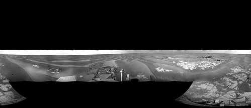
Near "Resolution" Crater - Opportunity sol 1825
QuickTime VR version (2.8MB)
Phil Stooke
... and the same pan in polar format, giving a nice view of the recent moves.

Phil

Click to view attachment
jamescanvin
Here is my estimate of what we are seeing in the Sol 1820 drive direction pancam Fred highlighted.

Pancam is a stack of the left and right frames. Background is and 'inverse-polar' projected HRSC image for our current location.

Click to view attachment

James
climber
QUOTE (mhoward @ Mar 13 2009, 06:39 PM) *
Near "Resolution" Crater - Opportunity sol 1825

Thanks Mike,
I'd have called it "Full Resolution" view wink.gif

ngunn
QUOTE (jamescanvin @ Mar 13 2009, 07:15 PM) *
'inverse-polar' projected HRSC image for our current location.


Sure it's not the crater beyond that one? smile.gif

I love that projection trick. I also love the fact that there are people here who care about the long views as I do. There is no scientific justification for it - it must be hardwired into us. Seafarers all.
This is a "lo-fi" version of our main content. To view the full version with more information, formatting and images, please click here.
Invision Power Board © 2001-2024 Invision Power Services, Inc.