CosmicRocker
Jan 20 2009, 05:59 AM
QUOTE (SteveM @ Jan 19 2009, 06:00 PM)

... I imagine the planners will not schedule much use of the Mössbauer (except at the next conjunction

) but the APXS shouldn't cause much of a problem.
I believe the Mössbauer is used to discriminate among various Fe minerals. As such, it will be difficult to predict how often it might become an important analytical tool. Considering the significance of iron compounds in Meridiani Planum, on Mars, and wherever planetary science is being performed, it is an important tool use frequently in the xyz directions of any exploratory campaign.
Prior to these rover missions, how many people have ever heard of a Mössbauer spectrometer? Certainly not me. Probably only a few here have. I'd like to know the answers to TTT's questions, considering how amazingly useful this analytic tool has been to the MER missions.
centsworth_II
Jan 20 2009, 08:15 AM
QUOTE (Nirgal @ Jan 19 2009, 03:14 PM)
But nevertheless I would interpret the shift in strategy after Victoria to put more more priority to driving with less routine observations in order to open the opportunity for science studies of entirely new discoveries encountered along the way.
It has been a long-stated goal by Steve Squires to examine cobbles after leaving Victoria Crater. The only question was which direction to head in while looking for them. They have now examined one cobble. How many more they will pass by and how closely they will look at them remains to be seen.
Tesheiner
Jan 20 2009, 08:47 AM
Some pictures from the new site are available here:
http://nasa.exploratorium.edu/mars/opportu...cam/2009-01-19/.
There was a 115m+ drive during sol 1774 and I'm now working on the map. It should be posted soon.
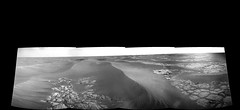
Phil Stooke
Jan 20 2009, 12:09 PM
Here's a reprojected partial panorama - makes it easier to see that crater off to the west.
Phil
Click to view attachment
mhoward
Jan 20 2009, 02:58 PM
Sol 1774:
Anaglyph:
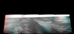
Not sure what that is in front of us (south) - a crater? Speed bumps?
SteveM
Jan 20 2009, 08:42 PM
QUOTE (CosmicRocker @ Jan 20 2009, 12:59 AM)
I believe the Mössbauer is used to discriminate among various Fe minerals. As such, it will be difficult to predict how often it might become an important analytical tool. Considering the significance of iron compounds in Meridiani Planum, on Mars, and wherever planetary science is being performed, it is an important tool use frequently in the xyz directions of any exploratory campaign.
Agreed, the Mössbauer is important, but a rough half-life calculation indicates that five years after landing the integration time will have to increase by a factor of 105 to get the same number of counts. Since the background count rate will remain constant, an even longer integration time will be needed to get the same S/N ratio.
The early Mössbauer integrations were several hours so we're looking at integration times measured in weeks, which will seriously delay our travel. I imagine the Mössbauer will be used sparingly.
Steve M
Tom Tamlyn
Jan 21 2009, 03:11 AM
Important Mössbauer integrations were allowed 24 hours even at the outset of the mission. See,
e.g.,
Roving Mars at 114 (describing two 24 hour Mössbauer integrations on El Capitan in Eagle Crater). The latest Opportunity
update suggests that the most recent integration occurred over 12 days, but doesn't specify if the instrument was in use continuously.
It would be interesting to hear if techniques exist for making effective use of shorter integrations with the instrument in its weakened state.
Roving Mars speaks of "tuning" the instrument for different kinds of readings. I wonder if it's possible to tune the instrument to a "coarse" setting that would yield at least a modicum of useful information from a quantity of radiation flux (if that's the right term) which earlier would have been considered too small to bother with.
CosmicRocker pointed out several posts upthread how few of us had ever heard of a Mössbauer spectrometer prior to the Rover missions.
Professor Mössbauer discovered the effect which bears his name in 1957 and is still with us (he turns 80 on January 31). It would be interesting to learn if he ever dreamed that Mössbauer spectroscopy would be used on Mars in his lifetime, and what he makes of the Rovers and their discoveries.
TTT
Tesheiner
Jan 22 2009, 09:51 AM
Here's the latest navcam mosaic, taken after the drive during sol 1776.
Click to view attachmentHave a look to the
route map and you will see that we are next to a little crater which was already visible from the previous site.
I'm eager to see the rest of the navcam pictures.
Stu
Jan 22 2009, 04:42 PM
Tesheiner
Jan 22 2009, 05:05 PM
A color mosaic perhaps and then go for good. My 2c.
Here's the crater in polar view.
Click to view attachment
mhoward
Jan 22 2009, 05:33 PM
QUOTE (Tesheiner @ Jan 22 2009, 10:05 AM)
A color mosaic perhaps and then go for good. My 2c.
I agree. It's a nice view, but I don't see any reason to linger here.
jamescanvin
Jan 22 2009, 05:44 PM
QUOTE (Tesheiner @ Jan 22 2009, 05:05 PM)
A color mosaic perhaps and then go for good. My 2c.
CODE
01777::p2287::06::80::80::0::0::2::162::pancam_ranger_crater_pt1_10x2_L257R1
Ranger. Nice name.

Sunspot
Jan 22 2009, 06:08 PM
Are those giant dunes that appear to be part of the horizon?
Oersted
Jan 22 2009, 10:23 PM
Funny how ecstatic we would have been if we had encountered this crater early in the mission. Now it is just, "yawn, drive on.."
Astro0
Jan 22 2009, 11:02 PM
Some may think that this is just another pothole on the Road to Endeavour, but I still think it's worthy of a photo
 Click to view attachment
Astro0
EDIT: A larger version (with no text) is now on my
blog.
centsworth_II
Jan 23 2009, 12:01 AM
QUOTE (Oersted @ Jan 22 2009, 05:23 PM)
Funny how ecstatic we would have been if we had encountered this crater early in the mission.
Yeah. Eagle Crater's outcrops pale in comparison. But Eagle lives in history as the most astounding first look any lander has had to date. IMHO
Click to view attachment
ElkGroveDan
Jan 23 2009, 12:10 AM
QUOTE (Astro0 @ Jan 22 2009, 03:02 PM)
We're moving again. What a relief! {/pun}
Floyd
Jan 23 2009, 12:17 AM
It would be great to get color images. The rocks look dark on the navcam compared to the pavement.
BrianL
Jan 23 2009, 04:54 AM
QUOTE (centsworth_II @ Jan 22 2009, 06:01 PM)
Yeah. Eagle Crater's outcrops pale in comparison. But Eagle lives in history as the most astounding first look any lander has had to date.
And it could easily have been the unluckiest landing spot in history. Imagine if Eagle had been a filled-in sand trap like so many craters encountered.

Vultur
Jan 23 2009, 08:09 AM
Speaking of filled in craters: Ranger looks like it must have a very deep layer of sand and dust in it, unless it was unusually shallow. Are the craters in this area old, or is the sand/dust just really prone to getting blown around? These craters look so much more filled in than things like Meteor Crater in Arizona. Are there estimates of their age?
Nirgal
Jan 23 2009, 09:32 AM
QUOTE (Astro0 @ Jan 23 2009, 12:02 AM)
Some may think that this is just another pothole on the Road to Endeavour, but I still think it's worthy of a photo
Astro0
Beautiful one, Astro0 !
jamescanvin
Jan 23 2009, 04:52 PM
An update gleaned from the PDT:
Second part of the Ranger pan tosol (to make a 15x2) then driving the sol after next (1780).

climber
Jan 23 2009, 10:00 PM
QUOTE (centsworth_II @ Jan 23 2009, 01:01 AM)
Is it me or the images processing by our wizards has improved THAT much ?
climber
Jan 23 2009, 10:02 PM
QUOTE (jamescanvin @ Jan 23 2009, 05:52 PM)
An update gleaned from the PDT:
Second part of the Ranger pan tosol (to make a 15x2) then driving the sol after next (1780).
I guess we're in restricted sols these days
jamescanvin
Jan 23 2009, 10:20 PM
I don't think you can say that based on this plan, as we stopped to image Ranger anyway. No driving on sol 1789 is likely a result of it being the weekend, restricted or not she could still have driven on that sol.
Of course we could be in restricted sols, I have completely lost track of when they fall.
climber
Jan 23 2009, 10:49 PM
I agree James.
Nevertheless I was (also) refering to this post:
http://www.unmannedspaceflight.com/index.p...st&p=127527 (mine actually) that was ok till conjunction but could have drifted ever since.
glennwsmith
Jan 24 2009, 07:44 PM
That is so damned cool, to be able to image a small crater (Ranger) from orbit and then drive right up to it! And again, this is exactly what Mars should look like -- a barren plain dotted with small craters!!! Tesheiner, Astro0, et al, thanks!
mhoward
Jan 26 2009, 04:44 PM
We've moved south. Bye-bye, Ranger.
Here's an anaglyph mosaic of the Pancam drive direction view south on Sol 1780:

Tesheiner
Jan 26 2009, 09:14 PM
Great!
Comparing the pictures taken from the current site with previous ones, specially the navcams, I have the impression that the ripples are becoming smaller again. Have a look to
the map too and scroll down from sol 1780's position.
Nirgal
Jan 26 2009, 10:46 PM
QUOTE (Tesheiner @ Jan 26 2009, 10:14 PM)
Great!
Comparing the pictures taken from the current site with previous ones, specially the navcams, I have the impression that the ripples are becoming smaller again.
Yup ! I'm hoping to resume our pre-conjunction 100+ meters-per-sol driving regime soon ...
However, I'm a bit concernd about a remark I read sometime ago, that due to the new Odysee passing times, Oppys daily driving window will be significantly restricted such that we can no longer do long single-sol drives. Could some one of the rover experts confirm this ?
djellison
Jan 26 2009, 11:15 PM
No reason why they couldn't carry on driving past the comms pass. It would mean a restricted-sols type situation for the end-drive location, but it would mean a longer drive if it was possible/required.
Doug
RoverDriver
Jan 26 2009, 11:49 PM
Except that later in the day we might have issues with post-drive imaging (yes that can be taken on the subsequent sol) and if autonav is used, driving with very little light can make things a bit difficult. I'm not sure about the impact on ambient temperature at that time of day.
Paolo
djellison
Jan 27 2009, 12:13 AM
I wasn't proposing post-drive imaging any later than it normally is, but we did read somewhere that MODY was being shifted to earlier in the day so that it wouldn't be fortuitously overhead at a normal 'done for the day' sort of time anymore.
RoverDriver
Jan 27 2009, 12:35 AM
QUOTE (djellison @ Jan 26 2009, 04:13 PM)
I wasn't proposing post-drive imaging any later than it normally is, but we did read somewhere that MODY was being shifted to earlier in the day so that it wouldn't be fortuitously overhead at a normal 'done for the day' sort of time anymore.
The times I heard there would not be much time post-ODY. Moreover, the drive happening post-ODY should check what happened in the drive pre-ODY. There are certain conditions which would be difficult to check/predict at the the time of sequencing. I'm not saying it can't be done, but it would make my life miserable ;-) I also know full well I have to get ready for this since it will likely happen on MSL as well (=drive sequences broken up in different time segments).
Paolo
jamescanvin
Jan 27 2009, 06:31 PM
Mosaic taken on 1773 named 'Pavement Textures' on the PDT site.

James
djellison
Jan 27 2009, 07:20 PM
Reminds me, ever so slightly, of Anatolia back up in the Eagle-Endurance days.
Tesheiner
Jan 27 2009, 09:07 PM
I'm wondering if we will see different kinds of bedrock once back on flat terrain...
Speaking of feature names, "Surveyor" (crater?) is on the list of images planned for today, sol 1782. My guess: it's the tiny crater almost S of the current position which will be imaged on a "mid-drive" mosaic.
Click to view attachment
RoverDriver
Jan 27 2009, 11:32 PM
That would be a good guess. The answer is in about 10 hours.
Paolo
RobertEB
Jan 28 2009, 02:24 PM
QUOTE (Tesheiner @ Jan 27 2009, 04:07 PM)
I'm wondering if we will see different kinds of bedrock once back on flat terrain...
Speaking of feature names, "Surveyor" (crater?) is on the list of images planned for today, sol 1782. My guess: it's the tiny crater almost S of the current position which will be imaged on a "mid-drive" mosaic.
Click to view attachmentI wonder if the three craters formed at the same time from meteor that broke into several pieces? They look similarly eroded.
mhoward
Jan 28 2009, 04:10 PM
Now this is exciting. Looks like there was a pretty long drive to the south and west on sol 1782. And although I'm no judge of these things, it looks like the drifts are thinning out quite a bit!
Here's the Navcam mosaic (so far), I left it in full equirectangular facing south in case anyone wants to reprocess it.

jamescanvin
Jan 28 2009, 04:53 PM
I think your right Mike. Looks like about 110m SSW
Phil Stooke
Jan 28 2009, 04:56 PM
jamescanvin
Jan 28 2009, 05:13 PM
If you believe my ripple size mapping then we're through the roughest seas.
Click to view attachmentGreen dot - approximate sol 1782 position
mhoward
Jan 28 2009, 05:13 PM
Look at that! Beautiful matchup.
Tesheiner
Jan 28 2009, 08:31 PM
QUOTE (jamescanvin @ Jan 28 2009, 06:13 PM)
If you believe my ripple size mapping then we're through the roughest seas.
My impression is that we already crossed the worst of it. Still rough but less on each driving sol.
Tom Tamlyn
Jan 28 2009, 09:38 PM
Do you mean the worst of the whole drive, or merely of this segment?
TTT
fredk
Jan 28 2009, 09:56 PM
Thanks for the location update on your ripple map, James. Looking at that map and Tesheiner's route map, I can see two options now. First, continue farther south, until we reach the smoother, blue region on the ripple map, then head east. The second option is to head east around now, following the patches of exposed bedrock, even though the ripples are somewhat higher here. I'll guess that they'll drive a few hundred metres farther south, then head east along the southernmost reaches of the current stretch of exposed bedrock.
On another topic, has anyone else noticed the small raised ridges in the bedrock at the sol 1782 location:
Click to view attachmentPresumably old fissures that filled with a harder material. Does anyone remember seeing features like this before?
mhoward
Jan 28 2009, 10:00 PM
QUOTE (fredk @ Jan 28 2009, 03:56 PM)
Does anyone remember seeing features like this before?
There were features like that
at in Endurance, IIRC. What I found interesting was the way the feature seems to be split, possibly implying some sequence of events.
Also the feature's placement way out here in the middle of nowhere might be interesting, although I don't know.
jamescanvin
Jan 28 2009, 10:26 PM
QUOTE (Tom Tamlyn @ Jan 28 2009, 09:38 PM)
Do you mean the worst of the whole drive, or merely of this segment?
Worst of the whole drive - depending on the route taken.
Several kilometers of these slightly smaller ripples before heading out onto the 'parking lot' (like the terrain around Eagle/Endurance) a couple of km's before 'mini-Endurance'.
Here is the whole route with a green dot for our approximate location.
Click to view attachmentA long way to go...
centsworth_II
Jan 28 2009, 11:03 PM
QUOTE (RobertEB @ Jan 28 2009, 09:24 AM)
I wonder if the three craters formed at the same time from meteor that broke into several pieces? They look similarly eroded.
If, since their formation, at the same time or different times, the craters were filled in and covered and are just now being uncovered, the similar degree of uncovering would be no indication that they were formed at the same time.
This is a "lo-fi" version of our main content. To view the full version with more information, formatting and images, please
click here.