Shaka
Oct 22 2008, 08:52 PM
The rest of us have driver's licenses, Stu has a poetic license.

So will it be the West Spur Route by Mike, or Rui's Route (west, then south)?
Only time will tell.
Stu
Oct 22 2008, 08:54 PM
You're right Shaka, and I just renewed my poetic license too. Cost a small fortune, and I had to have a new photo taken, but it's good through 2012 now, so it should see me through MSL's first few years of driving.

climber
Oct 22 2008, 09:17 PM
What country issue such a license?
Stu
Oct 22 2008, 09:22 PM
Narnia.

nprev
Oct 22 2008, 09:32 PM
Ah, he's too damn modest.
Stu has an unlimited poetic license from many countries, and the most important of these is the Country Of The Blind; he is their only light, and rightly treasured.
jamescanvin
Oct 22 2008, 11:04 PM
Another sol, another 127m WSW...
BrianL
Oct 22 2008, 11:12 PM
Sigh, just that much more distance to travel in the right direction.

mhoward
Oct 23 2008, 03:17 AM
QUOTE (jamescanvin @ Oct 22 2008, 04:04 PM)

Another sol, another 127m WSW...
It looks like it might have been longer, except the rover took a little detour (or zig-zag) in the middle of the drive. I'd love to know why, but for that we must wait...
At least it looks like she drove until late into the afternoon.
mhoward
Oct 23 2008, 03:42 AM
Tesheiner
Oct 23 2008, 05:30 AM
QUOTE (mhoward @ Oct 23 2008, 05:17 AM)
It looks like it might have been longer, except the rover took a little detour (or zig-zag) in the middle of the drive. I'd love to know why, but for that we must wait...
You don't know why?!?
It's because she found
Stu's sign in the middle of the plains.
Astro0
Oct 23 2008, 06:02 AM
This takes me back...
The Return of the Little Dune Dents!
It's been so long...did they ever figure out what they were, I can't remember?!
Click to view attachmentMeanwhile, over at
Gusev Crater...!!!
Ant103
Oct 23 2008, 06:59 AM
QUOTE (mhoward @ Oct 23 2008, 05:42 AM)
And the classic equirectangular pan


Tesheiner
Oct 23 2008, 08:40 AM
... and the classic
route map update too.
Just checked the tracking info and today is NOT a driving sol, probably because yesterday pictures were downlinked too late for panning the next move.
djellison
Oct 23 2008, 09:12 AM
I see what they're doing ( I think ) - heading far enough west whilst on good ground so that we can run south toward some etched terrain, running between dunes on the way, instead of hitting any side on.
Doug
Stu
Oct 23 2008, 02:19 PM
3D view of part of the scene
here, if anyone wants a look...
Gonzz
Oct 23 2008, 02:55 PM
There's something very poetic about the way these ripples stretch into the horizon.
They're showing the way to Endeavour
Magnificent desolation, once again
Floyd
Oct 23 2008, 03:44 PM
QUOTE (Astro0 @ Oct 23 2008, 02:02 AM)
It's been so long...did they ever figure out what they were, I can't remember?!
They decided that they were micro craters. This is the smallest yet.
ustrax
Oct 24 2008, 08:32 AM
QUOTE (Tesheiner @ Oct 23 2008, 09:40 AM)
... and the classic
route map update too.
I'm somehow pleased...comparing your
latest map with my
Valentine's delirium looks like finally I was able to get one direction right along this mission...
(Sorry for the low definition of my map but I've deleted the original...)
Click to view attachmentSee how I, through my fantastic precognitive powers, nailed the place where we would left Victoria?...

BrianL
Oct 24 2008, 12:17 PM
Well, I guess if you consider being a good 20 meters off "nailing it"...

ustrax
Oct 24 2008, 12:51 PM
What are 20 meters on a 12kms trek?...

BrianL
Oct 24 2008, 10:52 PM
Stu? Stu? Where did you go? I was going to remind you to check the dates.
Stu
Oct 24 2008, 11:05 PM
Posted in error, deleted in embarrassment
nprev
Oct 25 2008, 12:54 AM
Great quote as usual, Stu; you may have described my entire life quite concisely!
Enceladus75
Oct 25 2008, 02:54 AM
Onwards to Endeavour! If Oppy is able to manage 100 metres a day, how fast could it realistically get to the edge of Endeavour? 1 year, 2 years or more?
Juramike
Oct 25 2008, 03:06 AM
QUOTE (Shaka @ Oct 22 2008, 04:52 PM)
will it be the West Spur Route by Mike, or Rui's Route (west, then south)?
Oppy's position based on Eduardo Tesheiner's Opportunity Route Map and the UMSF terrain models are posted
here.
Looks almost like a straight line to the W Spur route entrance point.
(Maybe the Sol 1687 zig-zag was caused by Rui's super-secret mental powers acting on Oppy?)
-Mike
Shaka
Oct 25 2008, 05:30 AM
Yes, JM, the West Spur route is looking like a good bet at this point. The major difference in Rui's Route is that it ignores your red zone and runs straight down the middle of the etched terrain (exposed bedrock), midway between your West Spur and SW passages. Rui takes the geologists' preferences to heart and fearlessly confronts the big ripples. Beyond the red zone he continues in a more or less southerly route, whereas you loop back far to the east.
Which choice will Oppy make?
The tension is palpable.

Tesheiner
Oct 25 2008, 06:45 AM
Next move is planned for sol 1691 (Sunday) and the post-drive images are pointed due south.
ustrax
Oct 25 2008, 07:00 AM
QUOTE (Tesheiner @ Oct 25 2008, 07:45 AM)
Next move is planned for sol 1691 (Sunday) and the post-drive images are pointed due south.
If it's another 100 and something meters drive that will put Oppy on one third of the timeline my inner glowing oracle pointed as the requested for it to accomplish the first leg of the journey, 20 days.
If my clearvoyant batteries don't run out, see you at Endeavour on February 8, 2010...
climber
Oct 25 2008, 09:05 AM
QUOTE (ustrax @ Oct 25 2008, 09:00 AM)
see you at Endeavour on February 8, 2010...
Why on my 56th birthday ?
Juramike
Oct 25 2008, 01:06 PM
QUOTE (ustrax @ Oct 25 2008, 03:00 AM)
If my clearvoyant batteries don't run out, see you at Endeavour on February 8, 2010...
Anyone else notice how Oppy looks like the planchette of a Ouija board out there?
(Channelling secret mental powers to the W..to the W....to the W...)
Nirgal
Oct 25 2008, 01:35 PM
QUOTE (Enceladus75 @ Oct 25 2008, 04:54 AM)
Onwards to Endeavour! If Oppy is able to manage 100 metres a day, how fast could it realistically get to the edge of Endeavour? 1 year, 2 years or more?
I'm not a rover expert, but from the past experience with the Trek from Endurance to Victoria, I would say that a realistic estimate for Oppy's average "full speed progress" considering weekends, restricted sols etc. would be approximately 400 meters per week or about one and a half kilometers per month.
However, this "full speed" estimate does not include: 1. possible science stops and 2. unforseen incidents (stuck in dune, Odysee dropouts etc. )
So add another safety factor of two or so and we would have somwhere between 500 to 1000 meters per month on avareage which would result in an optimistic estimate of about 16 months for the whole Trek to Endevaour ...
SFJCody
Oct 27 2008, 10:35 PM
Ant103
Oct 28 2008, 09:55 AM
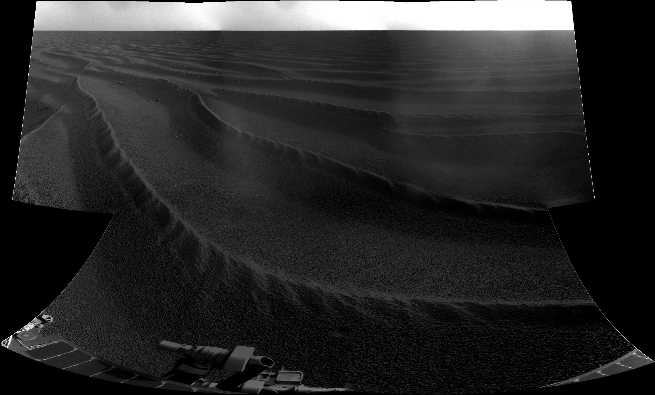
200 m ahead, back to the dunes on Sol 1691 :

ustrax
Oct 28 2008, 11:53 AM
QUOTE (SFJCody @ Oct 27 2008, 10:35 PM)
Looks like 1693 will be another driving sol.
That will endanger my estimative...but good to see that, somehow, Oppy will cross "my" path 8 months after dreaming of it...
Click to view attachmentAnd from Ant103's image looks like the tide is rising...
djellison
Oct 28 2008, 01:55 PM
QUOTE (Enceladus75 @ Oct 25 2008, 02:54 AM)
Onwards to Endeavour! If Oppy is able to manage 100 metres a day,
Don't go there. Don't start with a number and multiply it by numbers of days.
It
Never
Works
By that maths, Endurance to Victoria should have been <6 months. It was nearly two years. Just take it as it comes, step by step.
Doug
Nirgal
Oct 28 2008, 04:25 PM
QUOTE (Ant103 @ Oct 28 2008, 10:55 AM)
200 m ahead, back to the dunes on Sol 1691 :
Beautiful panorma, Ant !
this martian landscape never ceases to amaze me in its subtleness of change: how, for example the character of the dunes changes ever so slightly but distinctly only some hundreds of meters apart: for example, this "feathering" of the dune crests now looks even more pronounced and beatuiful than ever before ...
What an exciting adventure we have the privileg of taking part in !
BrianL
Oct 28 2008, 04:52 PM
Perhaps there is no basis for such fear, but those differences also worry me. They look like ripples we have driven safely before, but what if they turn at some point into soft, yielding ripples that can't be driven on anywhere, even in the troughs? I certainly feel more at ease when they are on one of the "highways". You know that safe, unyielding rock is near at hand,... er, wheel.
Ant103
Oct 28 2008, 05:03 PM
Thanks Nirgal. It's a privilege, I agree. And I am constantly proud to work on pictures taken yestarday and sometimes today ON MARS! Great times we are living now
.
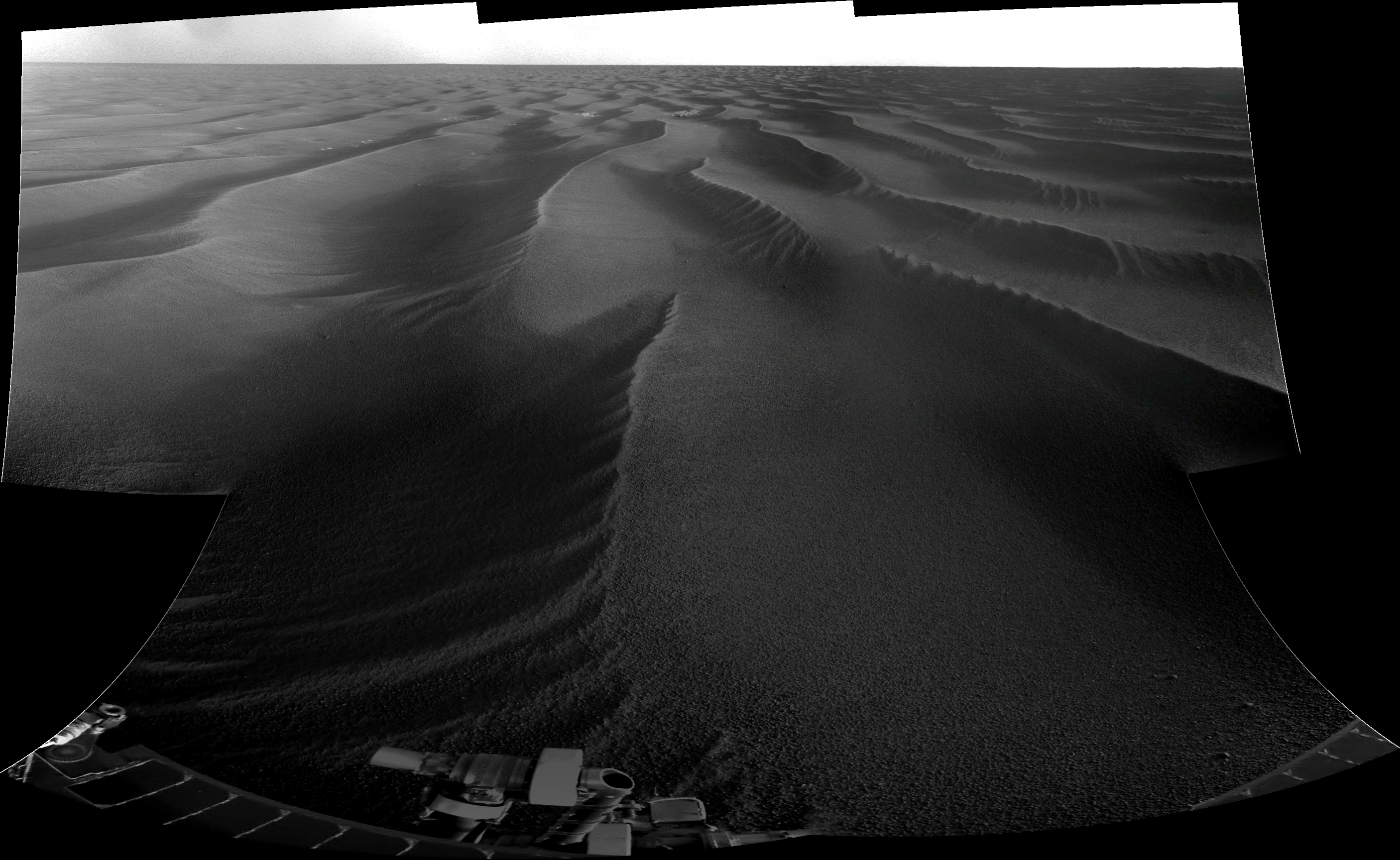
The drive direction, taken on the same sol :

Tesheiner
Oct 28 2008, 05:33 PM
> The drive direction, taken on the same sol
We should call it "sailing direction", perhaps.
Ant103
Oct 28 2008, 05:40 PM
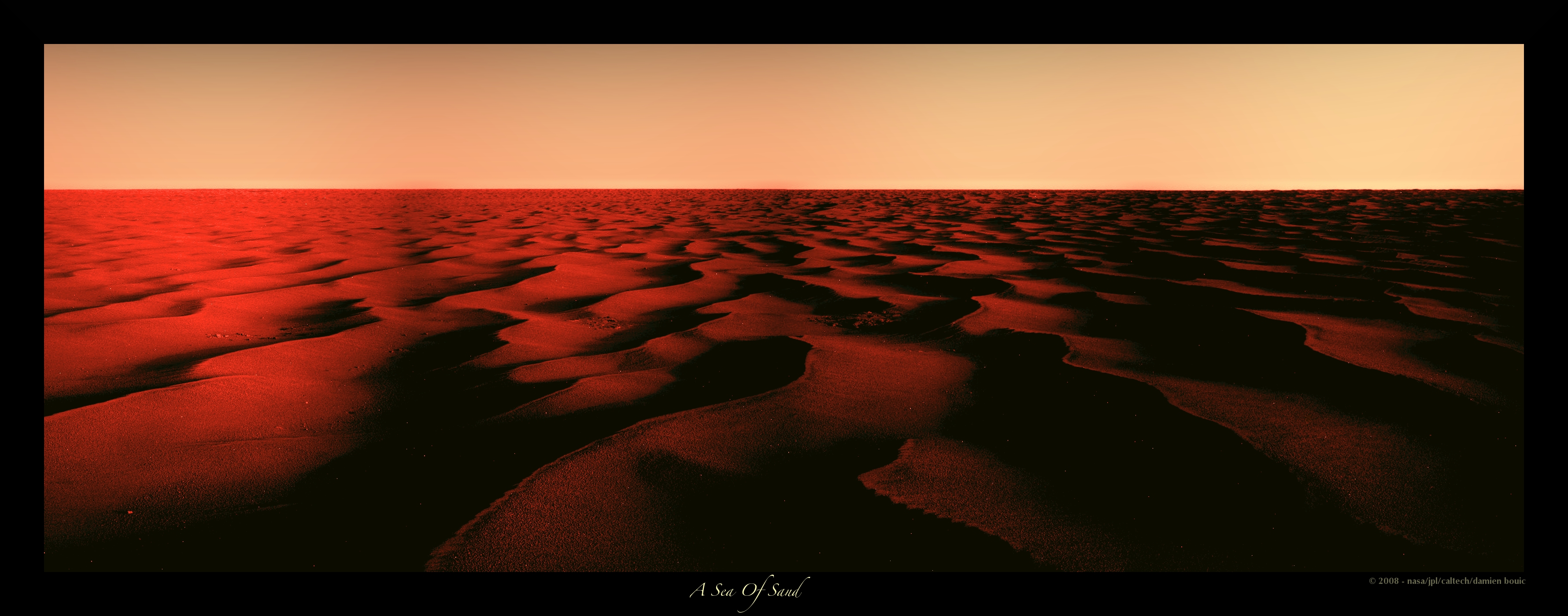
"sailing direction"An excellent transition to my next picture, from the black & white pan. I've named it "A Sea Of Sand"

climber
Oct 28 2008, 07:15 PM
QUOTE (Tesheiner @ Oct 28 2008, 06:33 PM)
We should call it "sailing direction", perhaps.
Let's even call it the "Red Sea of Sand of Meridianii"
Phil Stooke
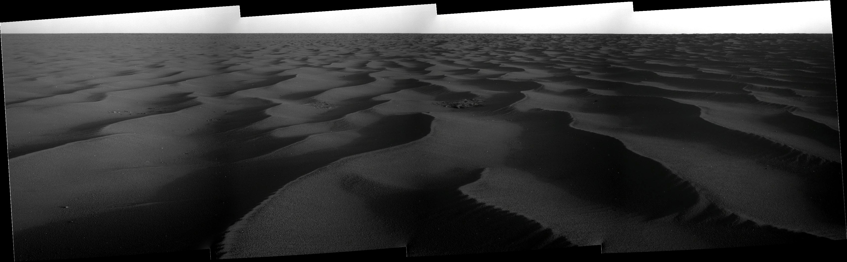
Oct 28 2008, 08:54 PM
This is the horizon part of Ant103's panorama of the drive direction, with a bit of vertical stretching. A factor of ten. It shows that smooth patch off to the left - east - and the bigger drifts ahead and to the right. Looks like the outcrop area is slightly elevated. This doesn't really look ideal to me. I think the immediate drive might be in this direction, but I would expect a turn to the west in a while to head towards that smoother route.
Phil
Click to view attachment
Tesheiner
Oct 28 2008, 09:20 PM
Good work Ant & Phil!
> I think the immediate drive might be in this direction, but I would expect a turn to the west in a while to head towards that smoother route.To the west or to the left - east?
I'm a bit puzzled by the current choice of route. There're smooth areas both to the west (W spur) and to the east (SW corridor) of the current position but everything, including today's planned post-drive images, indicates they are heading right to this big patch of bedrock due south.
Phil Stooke
Oct 28 2008, 09:44 PM
Either direction might work but I intended to say what I did say - right - or west, as I indicated on a map in the other thread.
Phil
marsophile
Oct 28 2008, 10:31 PM
QUOTE (Tesheiner @ Oct 28 2008, 01:20 PM)
Good work Ant & Phil!
> I think the immediate drive might be in this direction, but I would expect a turn to the west in a while to head towards that smoother route.To the west or to the left - east?
I'm a bit puzzled by the current choice of route. There're smooth areas both to the west (W spur) and to the east (SW corridor) of the current position but everything, including today's planned post-drive images, indicates they are heading right to this big patch of bedrock due south.
Quote: "Opportunity was headed for an area where the north-south dunes of Meridiani Planum were spread thinly over exposed bedrock, a landscape that would provide Opportunity with a "highway" southward on its journey toward Endeavour crater."
elakdawalla
Oct 28 2008, 10:39 PM
Don't read more into my update than is there -- that's no more than a summary of what appears to be the consensus view on this forum! You guys are my best "source" for MER news, as you all follow it much more closely than I do. I think we all agree that the direction of Opportunity's drive is taking it toward more driveable terrain -- the debates here are about exactly which direction it's headed.
I'm sure there will be more informed detail forthcoming this weekend when Salley will post her usual update.
--Emily
ustrax
Oct 28 2008, 10:58 PM
QUOTE (Tesheiner @ Oct 28 2008, 09:20 PM)
I'm a bit puzzled by the current choice of route. There're smooth areas both to the west (W spur) and to the east (SW corridor) of the current position but everything, including today's planned post-drive images, indicates they are heading right to this big patch of bedrock due south.
Why should you be puzzled when, apparently, the rover is heading towards bedrock? doesn't that mean safer drives? At least that was what I had in mind when marking my path, aiming whenever possible to patches of solid ground and not smooth dunes...but hey...what do I know?...
Phil Stooke
Oct 28 2008, 11:14 PM
Unfortunately, in this area the bedrock outcrops have the largest drifts scattered across them. So they are not a 'highway' as they were near Erebus.
Phil
belleraphon1
Oct 29 2008, 01:45 AM
Thinking the same thing, Phil... look like big dunes wandering the bedrock road ahead... we shall see .....
Looking at those sand sea vistas... I think of Arthur C. Clarke's "The Sands of Mars"... wouldn't we all love to be trotting along there in person... listening to the lonely whistle of wind....
Craig
Juramike
Oct 29 2008, 01:50 AM
QUOTE (belleraphon1 @ Oct 28 2008, 08:45 PM)
.. listening to the lonely whistle of wind....
I can't quite yet imagine what the wind would sound like...

This is a "lo-fi" version of our main content. To view the full version with more information, formatting and images, please
click here.