Help - Search - Members - Calendar
Full Version: Goodbye Victoria
Unmanned Spaceflight.com > Mars & Missions > Past and Future > MER > Opportunity
Pages: 1, 2, 3, 4
BrianL
QUOTE (Phil Stooke @ Oct 28 2008, 06:14 PM) *
Unfortunately, in this area the bedrock outcrops have the largest drifts scattered across them. So they are not a 'highway' as they were near Erebus.


Come on, Phil we're Canadians. That describes our highways perfectly. biggrin.gif
Pando
I think it's a great strategy having a sure footing of bedrock under the wheels and drive around the dunes. There is much less slippage and, with the availability of HiRISE maps, the route can be planned for longer distance ahead more accurately.
Tesheiner
QUOTE (Phil Stooke @ Oct 28 2008, 10:44 PM) *
Either direction might work but I intended to say what I did say - right - or west, as I indicated on a map in the other thread.

Understood. I got confused by your reference to the smooth terrain at the left on your Phil-o-vision.

QUOTE (Phil Stooke @ Oct 29 2008, 12:14 AM) *
Unfortunately, in this area the bedrock outcrops have the largest drifts scattered across them. So they are not a 'highway' as they were near Erebus.

That's my point too. However I hope we will see some clever usage of autonomous driving technics.

I'll use this same post to say that the drive planned for sol 1693 was executed and Opportunity moved another 110m due south. Expect bigger dunes right ahead.
wheel.gif wheel.gif wheel.gif
ustrax
QUOTE (Pando @ Oct 29 2008, 01:55 AM) *
I think it's a great strategy having a sure footing of bedrock under the wheels and drive around the dunes. There is much less slippage and, with the availability of HiRISE maps, the route can be planned for longer distance ahead more accurately.


Pando, my friend! Who would say we would be discussing this after all this years?... wink.gif
Those are exactly my thoughts, even if we recall that near Jammerbugt we had some bedrock too, I believe that solid ground + HiRISE maps + new software are, in my humble special cookie opinion, the best option for Opportunity in the current scenario.

Tesheiner, I'm curious to see your updated map... smile.gif
peter59
QUOTE (Tesheiner @ Oct 29 2008, 06:47 AM) *
Expect bigger dunes right ahead.

Click to view attachment Click to view attachment Click to view attachment
Stu
Yep, they look pretty big... and just plain pretty, too...

Sea of Sand

climber
QUOTE (Tesheiner @ Oct 29 2008, 06:47 AM) *
I'll use this same post to say that the drive planned for sol 1693 was executed and Opportunity moved another 110m due south. Expect bigger dunes right ahead.
wheel.gif wheel.gif wheel.gif

If I get it correctly we're in restricted sols up to nov 11th or so. So we expect to drive each other day.
Anyway, it's so nice to get distance with 3 digits values smile.gif
Ant103
Sol 1693 panoramas (navcam & pancam). I have the impression that this will be the traditionnal picturing set at the end of each drive smile.gif

Tesheiner
QUOTE (ustrax @ Oct 29 2008, 08:46 AM) *
Tesheiner, I'm curious to see your updated map... smile.gif


Done. smile.gif
ustrax
Obrigado!
I like too see paths converging... smile.gif

I know I shouldn't but I'm starting to doubt my powers... tongue.gif
A good alternative, following the bedrock policy, would be (contrary to my idea of following for more +-7kms SE) to turn East near the location where I lay the border between Leg 01 and 02 in the image below:
Click to view attachment
EDITED: Tesheiner's map date has been corrected, thanks for the alert hal9000!
ngunn
QUOTE (ustrax @ Oct 29 2008, 10:47 AM) *
I'm starting to doubt my powers...


Surely not! To settle matters I propose a rigorous empirical test: at the end of leg 1 the rover will clone itself and follow both your guesses. laugh.gif
PhilCo126
Does Opportunity currently hold the top 3 longest single-sol drives?
Sol 410 = 220 meters (722 feet)
Sol1663 = 153 meters (500 feet)

in fact amazing compared to Sojourner which drove a total of 101 meters (333 feet = easier to remember) in 1997...
climber
I bet for 222m on sol 2222, even easier Phil wink.gif
RobertEB
QUOTE (Ant103 @ Oct 29 2008, 04:51 AM) *
Sol 1693 panoramas (navcam & pancam). I have the impression that this will be the traditionnal picturing set at the end of each drive smile.gif


Two movie quotes come to mind;

"What a desolate place this is."

"Dune- Desert Planet- never one drop of rain on Arrakis"


I think the dunes of Mars are beautiful. When I look across that windswept landscape, I get a feeling that I have been there before. It feels like a place I have known, but there is something alien about it.
djellison
QUOTE (PhilCo126 @ Oct 29 2008, 01:41 PM) *
Does Opportunity currently hold the top 3 longest single-sol drives?


Yes. I think they might be 410 ( 220m ), a couple of sols ago (about 200 ), and probably either another drive from a few days previous to that, or one of the drives shortly before 410.
AndyG
QUOTE (RobertEB @ Oct 29 2008, 03:12 PM) *
"What a desolate place this is."


I don't know that one. I thought, for a moment, it was from R.F.Scott - but I'm misremembering his "Great God! This is an awful place." Another quote - sadly apocryphal - was allegedly an advert for Shackleton's Nimrod expedition. Forgive the minor re-write!

"[Robots] wanted for hazardous journey. Low wages, bitter cold, long hours of complete darkness. Safe return doubtful. Honour and recognition in event of success."

Andy
jmjawors
It's from Star Wars -- C3PO describing Tatooine. A very apt comparison! Especially if Oppy were to find moisture farms on her journey.

[/geek]
Oersted
Another take on the Sea.... (from Ant103's pano):


Click to enlarge.

- Cue Rod Stewart, "I am Sailing"....
Pando
Sorry...

BrianL
Ewww.... it's like the Gods were starting a Mars pysanka. blink.gif
mhoward
Some images from back on Sol 1686 came down, and it's a nice view (QuickTime, 3MB) - very appropriate for the "Goodbye Victoria" thread, since Victoria is just an elevated horizon to the northeast. Some light-colored exposed rock is visible in the distance to the southwest - that's about where Opportunity is today, on Sol 1694, or actually just past midnight on 1695.
SFJCody
On sol sixteen hundred and ninety five
M-E-R-B went for a drive
Oersted
QUOTE (Pando @ Oct 30 2008, 04:51 AM) *
Sorry...


laugh.gif
Shaka
O.K., compadres, it looks like Rui's Route and Paolo's agree at this point! smile.gif
The genes of Magellan triumph once more!
Rear HazCam
mhoward
Wow.

I did a quick Pancam anaglyph mosaic. It's not very good but it's all I have time for.


mhoward
Okay, and a quick Sol 1695 QuickTime VR, looking south.

These drifts don't look so tough. Except maybe that one to the left. Looking forward to seeing our position on the map...
Phil Stooke
It's about here.

Phil

Click to view attachment
Marz
QUOTE (mhoward @ Oct 30 2008, 10:02 PM) *
Okay, and a quick Sol 1695 QuickTime VR, looking south.

These drifts don't look so tough. Except maybe that one to the left. Looking forward to seeing our position on the map...


w00t! back on the Blueberry Highway!
Astro0
Hmm. A new drunken sailor technique or something else interesting. Unusual half frame look at the rear wheels.
Animation:
Click to view attachment

BTW - Is it time to start a new thread for this journey? Victoria is now 'far' behind. 'The Road to Endeavour: Leg One' perhaps. Tesh, Rui?
mhoward
QUOTE (Phil Stooke @ Oct 30 2008, 09:33 PM) *
It's about here.


I clearly don't understand how the driving on these drifts works. We drove right over some that I would have avoided. I hope the rest of the journey goes like this.
mhoward
QUOTE (Astro0 @ Oct 30 2008, 08:48 PM) *
Hmm. A new drunken sailor technique or something else interesting. Unusual half frame look at the rear wheels.


Making a mark for optical navigation?
CosmicRocker
I'd like to see the marks in a navcam image. It appeared more like a dance to me than a drunken stumble, but I can't quite name the dance step.
Pando
QUOTE (CosmicRocker @ Oct 30 2008, 09:59 PM) *
It appeared more like a dance to me than a drunken stumble, but I can't quite name the dance step.


It's the Yo-Ho Yo-Ho dance (see my earlier message)...

CosmicRocker
Hehe. Do you mean like this?

QUOTE
..."a pirate's life for me.
We pillage and plunder, we rifle and loot.
Drink up me 'earties, yo ho.
We kidnap and ravage and don't give a hoot.
Drink up me 'earties, yo ho."

We must be careful about the waves and the pirates on this voyage. wink.gif
ustrax
QUOTE (Shaka @ Oct 31 2008, 02:43 AM) *
O.K., compadres, it looks like Rui's Route and Paolo's agree at this point! smile.gif


Look Ma! No algorythms! tongue.gif
Click to view attachment
Stu
Oppy on the rocks... ain't no big surprise... wink.gif
Juramike
I wonder if they chose this route to try out some of the new automatic driving software on more challenging terrain?

Or if they have some science targets in mind?

Either way, this will provide a great opportunity (!) to try and correlate with predicted models as they drive over increasingly difficult terrain. (Are the drivers using this to test out their terrain models?)

-Mike
Geert
QUOTE (Juramike @ Oct 31 2008, 05:24 PM) *
I wonder if they chose this route to try out some of the new automatic driving software on more challenging terrain?


Sounds unlikely to me, the software can be easily tested on earth using simulations or backup hardware, no use to do the testing on Mars. Also, which ever route they select, there will always be challenging terrain ahead so not much use to run as fast as possible towards the highest dunes.

QUOTE (Juramike @ Oct 31 2008, 05:24 PM) *
Or if they have some science targets in mind?


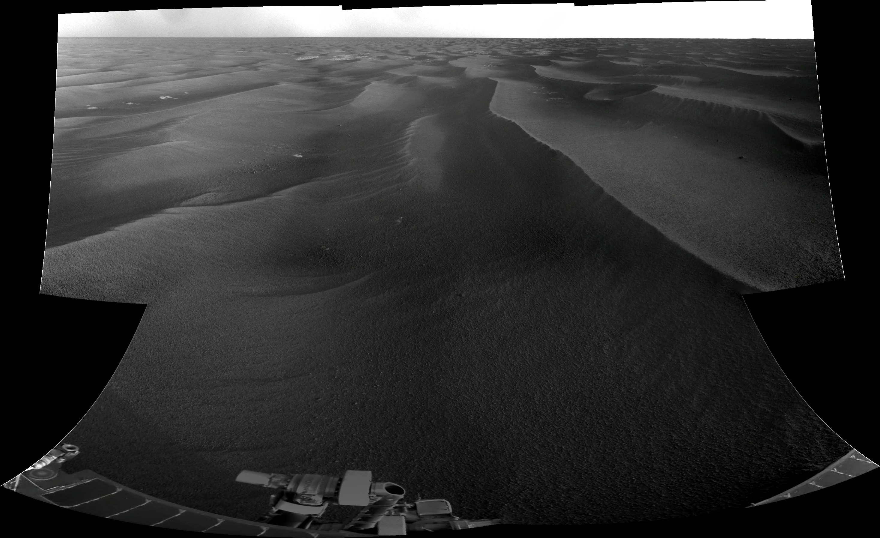
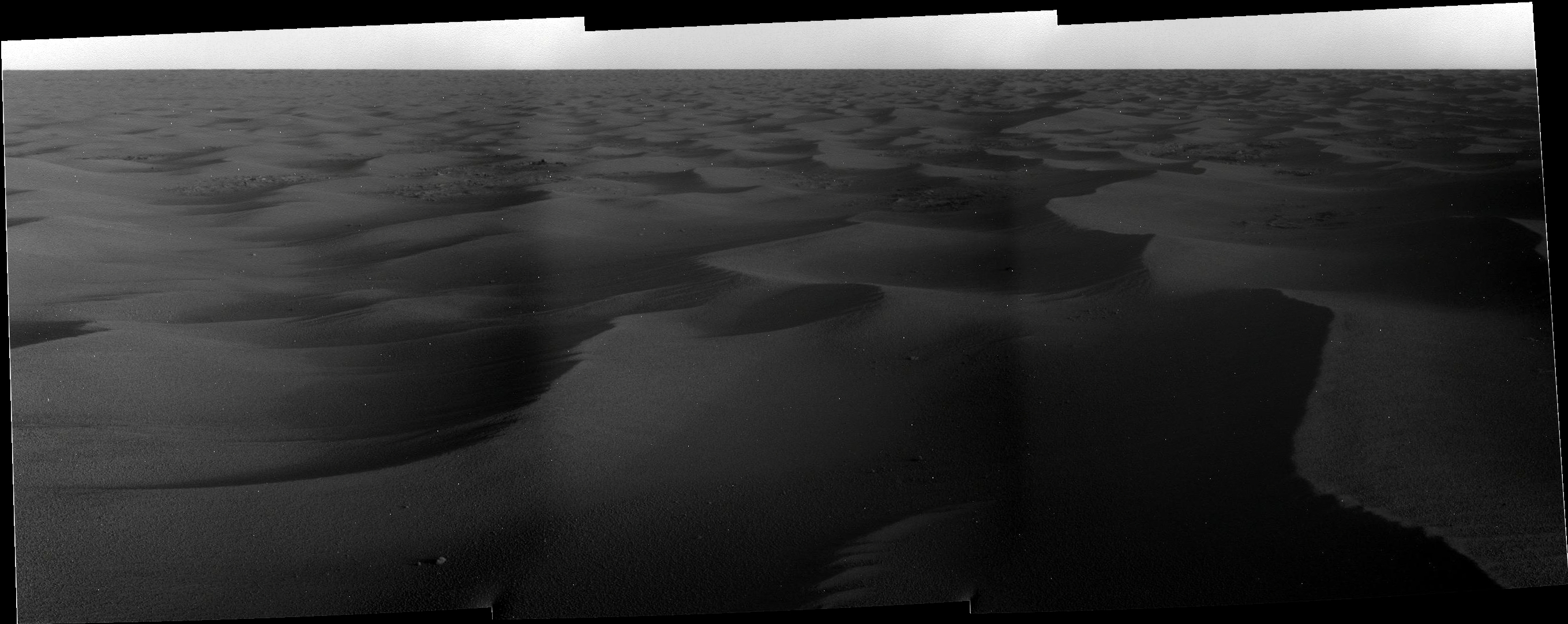
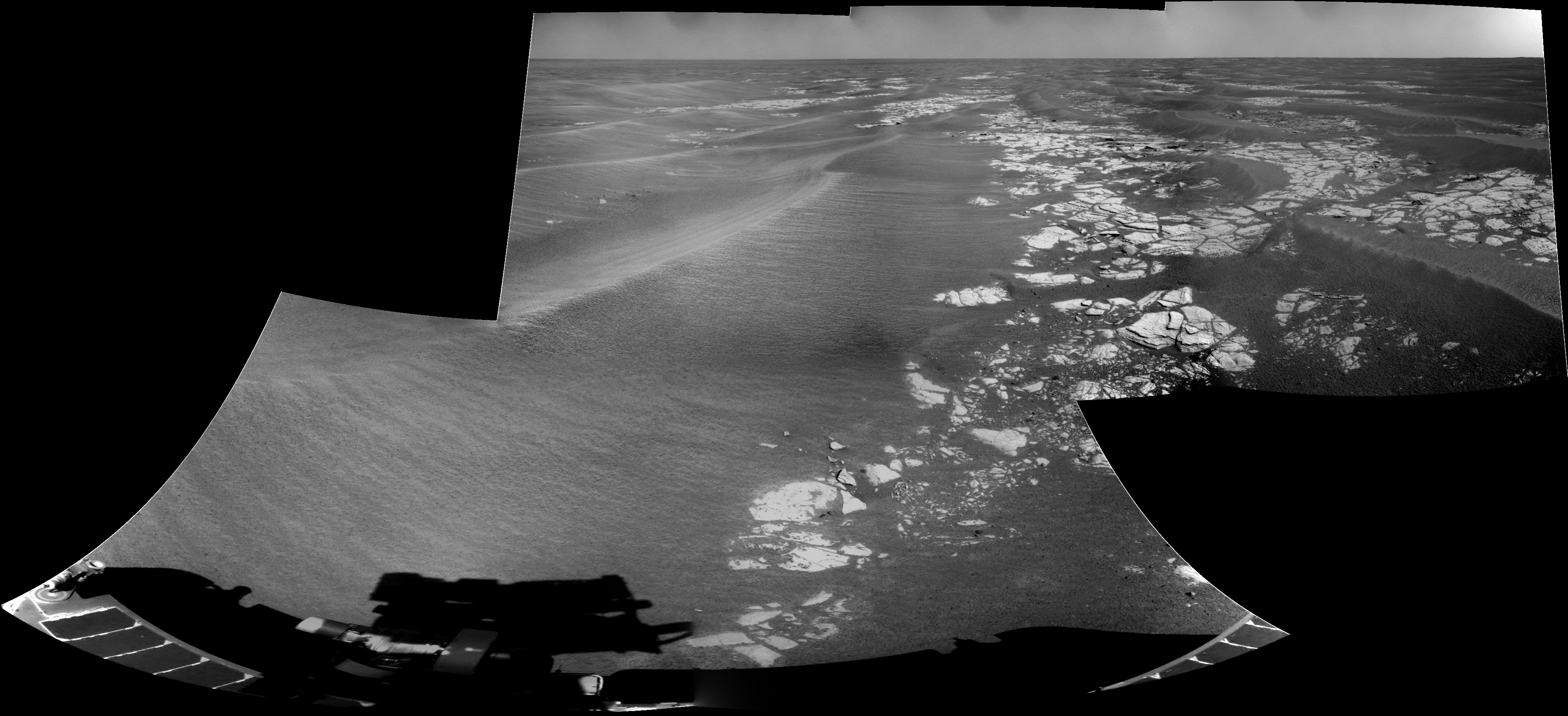
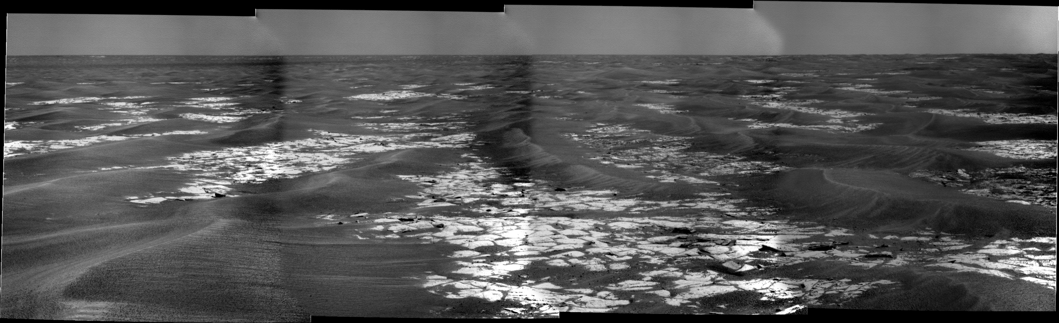
Sounds more likely to me, bedrock is a lot more interesting then sand and there might be other reasons. Looking at the HiRISE images I don't believe so much in the 'highway' story, there are some open stretches with bedrock but further on the 'wavelength' of the dunes gets less and there are a lot of cross-dunes, to me this doesn't look like terrain where you can make a lot of speed. But probably the real drivers have more information and certainly far more experience.

What worries me is the risk of loosing a wheel, this isn't the sort of terrain to drive through with only 5 wheels I should think... Why steer yourself into this maze if there is nice flat ground close by? But there is more on heaven and earth then thou hast dreamed of..

QUOTE (Juramike @ Oct 31 2008, 05:24 PM) *
Either way, this will provide a great opportunity (!) to try and correlate with predicted models as they drive over increasingly difficult terrain. (Are the drivers using this to test out their terrain models?)


Or ours? laugh.gif
Ant103
Sol 1695 navcam and pancam set wink.gif


Nirgal
QUOTE (Geert @ Oct 31 2008, 11:48 AM) *
QUOTE
Or if they have some science targets in mind?


Sounds more likely to me, bedrock is a lot more interesting


I hope not too soon wink.gif

We studied this kind of bedrock literally a thousand times by now (like the long stop at Olympia etc.)

If I understood the new rover strategy correctly, then now is the time to reverse the priorities from rock studies to driving for a while ...

and spare the science for the important cases when/if we find something *really* new ...

smile.gif
PhilCo126
Don't mention "science targets" we're on the road again... wheel.gif wheel.gif wheel.gif wheel.gif wheel.gif wheel.gif
marswiggle
An anaglyph of Oppy's current locations from HiRise imagery, looking to the south, shown at a slightly oblique angle. The resolution is full transversely (at the bottom) and ~65 % longitudinally. Note that the 'real' depth in the anaglyph is relative to the (image) surface, so there's no visual depth in the seemingly oblique perspective which is just a simple visualization tehcnique.

The beginning of the drift-free highway about 400 m south from Oppy is just visible near the upper right corner.
Tesheiner
Some tidbits from the monthly status report @ TPS:
(thanks Bobby for the heads up)

Last weekend, we did a 216-meter drive that fell short of our all-time record by just 4 meters," offered Squyres.

Both Spirit and Opportunity are downlinking data every day to free up flash memory space in preparation for solar conjunction ... The solar conjunction begins at the end of November, so the team has charged the rovers with getting all recent images and science observations home so there will be plenty of room to store the data collected during the solar conjunction.

The plan is to head southwest “to intersect some terrain that has a fair amount of pavement-like outcrop on it,” Squyres said. Expounded Matijevic: "This area [which has not yet been named] is about a kilometer or kilometer and a half south of Victoria and we're moving pretty well along the rim of the crater down towards that outcrop." From that point, said Squyres, "we'll just follow the yellow brick road to the south."

... "We've been keeping our eyes open and every day we look around for a cobble to look at," Squyres said. The team would like to find one on which the rover can place its instrument deployment device (IDD) during solar conjunction, he noted.

We've had to go a little bit out of our way with Opportunity, but we have generally been traversing fairly well," said Matijevic. Even so, he added, "the path we sort of picked to the new crater goes around some of these obstacles, the purgatoids, and probably means we'll be driving more like a total of 18 kilometers to get to the edge of Endeavour."


Edited: During the final sols of September, Opportunity crossed the 12-kilometer (7.5-mile) milestone ...

... and already crossed the 13km milestone too (sol 1695, if I'm not wrong). wheel.gif wheel.gif wheel.gif
DFinfrock
[ "we'll be driving more like a total of 18 kilometers to get to the edge of Endeavour."]

That sounds like a long way. But Oppy did 216 meters in one day. A 180 meter drive in a single day puts us 1% of the way there. We only need 100 of those 180 meter drives to get there!

wheel.gif wheel.gif wheel.gif wheel.gif
climber
A little reminder : she was garenty for 600m during her whole life smile.gif
djellison
Has done 13k, asking for another 18k, so a total ask of 31km


Geert
QUOTE (djellison @ Nov 1 2008, 06:34 AM) *
Has done 13k, asking for another 18k, so a total ask of 31km


Which would mean she is getting closer to the all-time record set by the Soviet Lunokhod 2, which travelled 37 km (on the moon). Never thought that the MER's would get anywhere near that distance, there is a big difference in how both machines were run (reflecting the difference in distance earth-moon and earth-mars) and the Lunokhods were moving a lot faster.
mhoward
Some older images came down. Here's my attempt at the Sol 1691-1692 Navcam QuickTime VR (2.3 MB). I've adjusted this one so you can zoom way out; pan all the way down for a pseudo-polar. And it starts out looking south.
Tman
Wow, that's nearly perfect. Thanks Michael!

RoverDriver
QUOTE (Astro0 @ Oct 30 2008, 07:48 PM) *
Hmm. A new drunken sailor technique or something else interesting. Unusual half frame look at the rear wheels.
Animation:
Click to view attachment

BTW - Is it time to start a new thread for this journey? Victoria is now 'far' behind. 'The Road to Endeavour: Leg One' perhaps. Tesh, Rui?


Tap, tap. Is this thing on? Well, it seems that for the time being I can post, with some restrictions, to UMSF!

--

These subframe RHAZ were taken to monitor the path taken during the autonav portion of the drive. Autonav is pretty CPU intensive and it depends on how wide is the area analyzed in front of the rover. If we use only a single NAVCAM frame we can only drive straight ahead. In this configuration autonav will only stop the rover in case the road straight ahead is blocked.

As you are aware, the stuck RF wheel makes our "straight ahead" driving drift to the left. So from time to time the rover needs to correct the heading but in order to do so we need to use ore than one NAVCAM frame, which makes it a much slower driving. We are experimenting with some techniques to reduce the wider field of view autonav to a minimum and therefore make as much progress as possible given the alloted time for driving.

Paolo
This is a "lo-fi" version of our main content. To view the full version with more information, formatting and images, please click here.
Invision Power Board © 2001-2024 Invision Power Services, Inc.