That puts the site about here, to put it in context.
Phil
Click to view attachment
Full Version: Sol 22 and after
QUOTE (Stu @ Jun 22 2008, 11:45 AM) 
Sol 25 Wonderland trench...
amazing!
Can't wait for them to start digging deeper. Any ideas on how deep they would like to go?
The layering in the trench should be interesting if they are able to dig deep.
I hope everyone is receiving twitters from the lander. Soon to be ranked 7th on the twitterholic page. Number 4 seems doable
JB
The layering in the trench should be interesting if they are able to dig deep.
I hope everyone is receiving twitters from the lander. Soon to be ranked 7th on the twitterholic page. Number 4 seems doable
JB
QUOTE (jabe @ Jun 22 2008, 07:17 AM)
Can't wait for them to start digging deeper. Any ideas on how deep they would like to go? ...
That's an easy one.  They surely would want to dig as deeply as possible, as that would likely provide the longest line of geological/climatalogical history at this location. But then we would want to study that vertical section in context, requiring additional lateral excavations.
 I get the impression that the concern here is about a shallow ice table that might prevent digging deeply, thus the earlier suggestion that Phoenix might need to strip mine the national parks, to at least expose the topography of this local ice table. I suspect deeply-digging might be easier near the polygon boundaries, but I am not sure how those boundaries align with the digging degrees of freedom of the robotic arm. I can't wait to see what Phoenix does next...
Ok, this brings up a question I've had for a while now which I may as well ask at the risk of sounding like an ignoramus.  Do we know how deep this ice layer should be? Do we have MEX or MRO data from their radars about this? I know there were press releases from MRO (I think) that showed an image produced by SHARAD of the north polar region, but it didn't really elaborate on what we were seeing.
Anyone have any more insight into this?
Do we know how deep this ice layer should be? Do we have MEX or MRO data from their radars about this? I know there were press releases from MRO (I think) that showed an image produced by SHARAD of the north polar region, but it didn't really elaborate on what we were seeing. Anyone have any more insight into this?
Sol 027: Exit safe mode ???
Yes, what's with no images received on sol 27?
Lemmons caption says they went into Safemode....
Sol 027: Exit safe mode (was: WCL test, remote sensing, hold sample for WCL)
Sol 027: Exit safe mode (was: WCL test, remote sensing, hold sample for WCL)
I somehow missed that bit. It seems that after a near-perfect landing at a perfect location they've been having quite a bit of trouble ever so often, regardless be it with orbital or ground assets. Hope it's just a pesky cosmic ray hit this time.
Sol 28 images are going up...
The main ice exposure at the far end of Dodo/Goldilocks is continuing to darken:
http://www.met.tamu.edu/mars/i/SS028EFF898...5_132F0L1M1.jpg
It's easy to predict that the entire exposure will be dark in not too many sols. I'm intrigued by the fact that the darkened ice surface is actually darker than the surrounding soil, as I've mentioned before. I wonder how Holy Cow is doing.
This rapid darkening helps illustrate why we see no naturally exposed ice patches around (indeed, perhaps we should be looking for unusually dark, rather than light, areas!). Perhaps it also explains why we saw nothing bright in the heatshield crater (although that may have involved dark debris from the heatshield itself).
That's a neat observation - that the lighter toned, presumably icy, patches become darker over time. This is, perhaps, due to the sublimation of an ice/soil mixture which leaves a soil residuum when the ice sublimates. But, what causes the darker tone, and should we expect the darker area to become lighter-toned with time? That is will the darker toned areas eventually attain a tone which is similar to the surrounding soil?
Just a reminder that if the color becomes darker than the surrounding soil, one possibility might be a wetting effect due to brief melting in the sunlight? Perhaps there are other possible mechanisms as well as Gray mentions.
Also we apparently see some very isolated naturally exposed ice patches in some orbiter images of the general landing zone, as mentioned in another thread.
http://www.unmannedspaceflight.com/index.p...st&p=118986
Steve
Also we apparently see some very isolated naturally exposed ice patches in some orbiter images of the general landing zone, as mentioned in another thread.
http://www.unmannedspaceflight.com/index.p...st&p=118986
Steve
Is this an expected amount of dust accumulation on the magnets after 28 sols?
I seem to remember the rovers' calibration targets staying cleaner than this, but I might be mistaken.
I seem to remember the rovers' calibration targets staying cleaner than this, but I might be mistaken.
Many of the Phoenix color image sequences are captured over enough time to cause the shadows to change between RGB exposures and thus appear noticably misaligned. Is this because the RGB components can't be made in a rapid sequence? The edges of rocks and shadows will suffer from color fringing across otherwise excellent color panoramas unless attantion is paid to this. Similar products from other recent surface cameras seem to have little of this problem.
QUOTE (DDAVIS @ Jun 23 2008, 08:27 PM)
Similar products from other recent surface cameras seem to have little of this problem.
This issue is present in MER imagery as well. Given automatic exposure adjustment, filter changing time, frame compression times with slow (by modern PC standards) flight computers, a couple of minutes can easily pass between consecutive frames. This is enough to make long shadows move over 3 exposures.
QUOTE (Stu @ Jun 23 2008, 08:53 AM)
Sol 28 images are going up...
Is that soil hanging from the edge of the scoop?
Now what would cause that? Moisture? Static cling seems unlikely.
QUOTE (ZenDraken @ Jun 23 2008, 07:56 PM)
Is that soil hanging from the edge of the scoop?
Now what would cause that? Moisture? Static cling seems unlikely.
Now what would cause that? Moisture? Static cling seems unlikely.
I'd go with electrostatics.
QUOTE (ZenDraken @ Jun 23 2008, 04:56 PM)
Is that soil hanging from the edge of the scoop?
Now what would cause that? Moisture? Static cling seems unlikely.
Now what would cause that? Moisture? Static cling seems unlikely.
The soil is not "hanging" from the scoop. The blade is just bleeded out by sunlight.
That soil is neither hanging off the edge of the scoop, nor are we seeing ccd bleeding. In this image we can see that the true bottom edge of the scoop is below the apparent bottom in that original image:
http://phoenix.lpl.arizona.edu/images/gallery/lg_7298.jpg
Also see this image:
http://planetary.s3.amazonaws.com/data/pho...5_131D0MBM1.jpg
http://phoenix.lpl.arizona.edu/images/gallery/lg_7298.jpg
Also see this image:
http://planetary.s3.amazonaws.com/data/pho...5_131D0MBM1.jpg
Ahhhh! Thanks for illuminating that!
(I pull back my electrostatic comment)
(I pull back my electrostatic comment)
QUOTE (fredk @ Jun 23 2008, 07:08 PM)
That soil is neither hanging off the edge of the scoop, nor are we seeing ccd bleeding. In this image we can see that the true bottom edge of the scoop is below the apparent bottom in that original image:
http://phoenix.lpl.arizona.edu/images/gallery/lg_7298.jpg
Also see this image:
http://planetary.s3.amazonaws.com/data/pho...5_131D0MBM1.jpg
http://phoenix.lpl.arizona.edu/images/gallery/lg_7298.jpg
Also see this image:
http://planetary.s3.amazonaws.com/data/pho...5_131D0MBM1.jpg
Thanks, I feel slightly less stupid now!
QUOTE (fredk @ Jun 23 2008, 09:08 PM)
Also see this image:
http://planetary.s3.amazonaws.com/data/pho...5_131D0MBM1.jpg
http://planetary.s3.amazonaws.com/data/pho...5_131D0MBM1.jpg
What is thi site? I tried to get down to the root directory at "http://planetary.s3.amazonaws.com/" and got a "forbidden" error window. I've not heard of this site.
--Bill
That's Planetary Society's server. The image was nicked from Emily's blog.
Oh, I didn't mean nicked in a negative way. Yes, it's not off her blog directly, but her raw page. Mea culpa!
High-reolution view of the heatshield impact (near the upper left):
http://www.met.tamu.edu/mars/i/SS028EFF898...8_11E1EL1M1.jpg
Has it collapsed completely?
http://www.met.tamu.edu/mars/i/SS028EFF898...8_11E1EL1M1.jpg
Has it collapsed completely?
It's probably just behind local topography, like the 'chute.
Doug
Doug
I estimate the heatshield is about 150 metres away, from the hirise images. The top of Oppy's heatshield was at roughly 1 metre above the ground. At 150 metres, a 1 metre tall object would span nearly 30 pixels in a full frame SSI image:
Click to view attachment
So either the heatshield has flattened dramatically, or there is some pretty dramatic topography out there (metre-scale, rather than the roughly 10cm scale we have nearby, I believe), or some combination of both of course. On the other hand, it wouldn't be surprizing if the heatshield slid/rolled into a local low point/trough after impact.
Just as a reminder, here's an image of Oppy's heatshield from a comparable distance:
http://marsrovers.jpl.nasa.gov/gallery/all...00P2356L7M1.JPG
Of course, that was on the almost-atomically-flat tarmac!
Obviously, some homeless Martian has made off with it for a shelter. I mean, what other explanation is there? 
Brian
Brian
.
QUOTE (BrianL @ Jun 25 2008, 10:07 AM)
Obviously, some homeless Martian has made off with it for a shelter. I mean, what other explanation is there?
Brian
Brian
Well, you could get imaginative and suggest that the hot heatshield melted down into the ice like the "China Syndrome" and that it's currently conducting an independent exploration of the secret subterranean seas of Barsoom

There's a noticeable ridge/height (in relative terms) in the landscape about at the distance of the heatshield, and well before the backshell, judging from these 3-d (x-eyed) crops. Look particularly the backshell, a metre-scale drop of the ground seems quite plausible.
Shhh. I know where it's gone!
It's fallen into.......wait for it............an "abyss" !

Sorry, couldn't help it!
Astro0
It's fallen into.......wait for it............an "abyss" !
Sorry, couldn't help it!
Astro0
If you look at the foreground in this 3D image I posted a while ago, I think it's pretty clear there are some serious dips and drops around Phoenix...
Click to view attachment
... and I'm still intrigued by that bright "patch" in the foreground, which no-one commented on when I pointed it out the first time...
Edit: if you find that pic a bit dark, try this one...
Click to view attachment
... and I'm still intrigued by that bright "patch" in the foreground, which no-one commented on when I pointed it out the first time...
Edit: if you find that pic a bit dark, try this one...
QUOTE (fredk @ Jun 24 2008, 08:41 PM)
Oppy's heatshield..
...did something really unusual and belly-flopped it's way to making a little inside-out structure. That didn't happen for Spirit, which just broke into a few pieces and sat flat on the ground. The heatshields are not 1m tall.
Doug
The surface is definitely not as flat as everyone seems to think it would have been, which is nice really.....
Also I forgot how flat Miridiani is !! flat flat flat.........
Also I forgot how flat Miridiani is !! flat flat flat.........
QUOTE (Stu @ Jun 25 2008, 07:53 AM)
I'm still intrigued by that bright "patch" in the foreground, which no-one commented on when I pointed it out the first time...
They are interesting, but I'd be more intrigued if the light patches had a different hue from the rest of the soil, and the hues look similar to me...
Sol 29 color:

From what I can tell, there is zero change in the righmost trench with that grayish stuff.
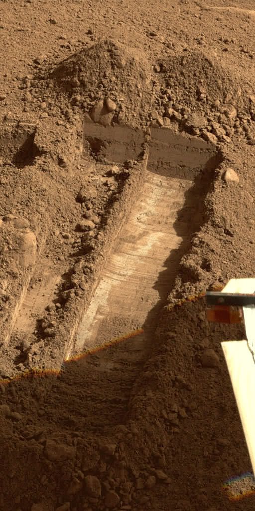
From what I can tell, there is zero change in the righmost trench with that grayish stuff.
QUOTE (MahFL @ Jun 25 2008, 11:26 AM)
The surface is definitely not as flat as everyone seems to think..
*cough* Not quite everyone... I wouldn't mention it if it weren't so rare for me to be right about something
Edit - both Stu's anaglyphs and the official SSI animation of the workspace show lots of vertical relief on the 10s of cm scale.
So... when are we going to start seeing some *deep* trenching?
I'd think that we'd need to first remove the upper regolith from a reasonably large patch and then start working on digging directly into the ice substrate. If we ever want to get ice samples into TEGA and WCL, we'll need to be working directly in the ice layer, I would think.
So far, I've not seen anything deeper than down to the very top of the ice layer -- we hit it and then we go off to the side. I grant you, it may not be easy to dig through the ice layer, but from the looks of things (and someone correct me if I'm wrong), it doesn't look like we have yet even tried.
-the other Doug
This question's been asked in press briefings. There's no intention to dig deeply into ice -- the deep digging discussed in the mission planning was to get to the ice, not into it. Digging now will be to expose the ice table, examine its contours, see what happens as it goes toward the polygon boundaries. They'll rasp into it to get samples but my understanding is that they don't plan to try to get deeply into its interior -- if I understand correctly, they won't get more than a few millimeters into it.
--Emily
--Emily
They seem to be confident of being able to get some ice into the most accessible TEGA ovens - the end ones - before it sublimes away. That's an admirable goal but I think achieving it may not be at all straightforward. I say go for it and good luck!
What about the chances of delivering ice to the other instruments - any thoughts?
What about the chances of delivering ice to the other instruments - any thoughts?
TEGA is really the main instrument for ice. Ice in the WCL, for instance, wouldn't tell them much at all since it's just adding water to water. They'd definitely have to work fast to catch some in the microscope, but it'd be worth a try IMO.
Apparently the RAC has a macro mode:

QUOTE (ahecht @ Jun 26 2008, 10:48 PM)
Apparently the RAC has a macro mode:
That's sort of the point of it - adjustable focus to fully image the contents of the scoop.
Doug
This is a "lo-fi" version of our main content. To view the full version with more information, formatting and images, please click here.