slinted
Jun 15 2008, 04:00 PM
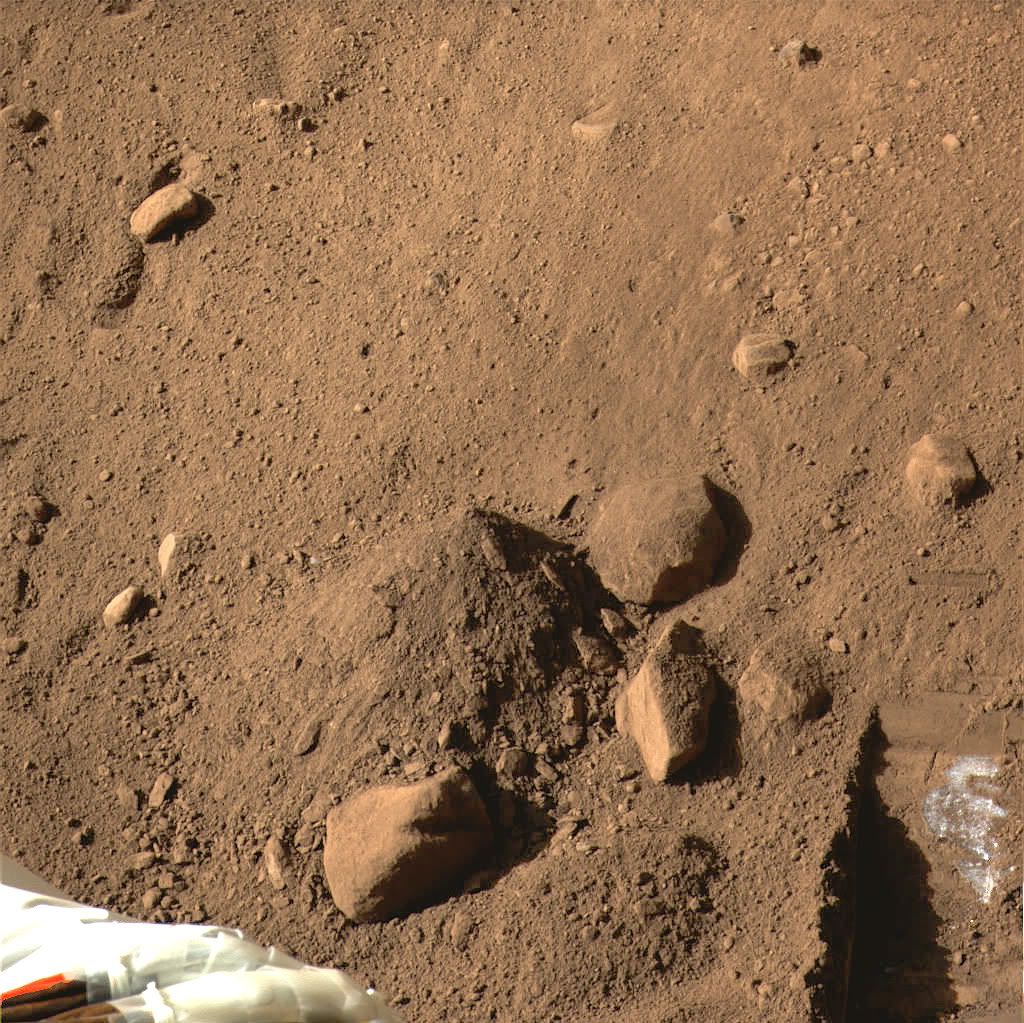
Comparison of sol 19 and sol 20 dig site:
 (click through for animation)
jekbradbury
Jun 15 2008, 05:37 PM
Here's an RGB mosaic of the dig site and the dump pile, sol 20:
Click to view attachment
Decepticon
Jun 15 2008, 06:19 PM
How deep is that at deepest point?
glennwsmith
Jun 15 2008, 07:26 PM
Jekbradbury, you've really worked magic with your colorizing of the trench image.
It's hard to believe that there can be a mission to rival the excitement of the MERS, but here it is! And as Stu can elaborate for us, there is no more engaging tale than the dig, the next scoopful of earth revealing a wooden chest, a marble head, a bison rib with paleo point embedded -- or white, aeons-old ice beneath the dry, red dust of Mars!!!
Phil Stooke
Jun 15 2008, 07:45 PM
Yes, there was some scepticism before landing that Phoenix would rival MER for interest. But it does.
And what do we do after Phoenix and - shudder - MER are all deceased? Let me suggest that these trench animations and other goodies could be repeated for Viking. I imagine a "Virtual Viking" mission, with people taking Viking images sol by sol - easy to find in the Planetary Image Atlas - and recreating that mission from scratch. Day by day trench digging early in the mission, plus longer range surface changes, all animated and coloured. What's out there now is very mediocre - this would really bring some amazing space history to life.
Phil
Reckless
Jun 15 2008, 07:47 PM
Jekbradbury
That's the most ice like picture of the white stuff in the trench yet.
good picture

Roy
ugordan
Jun 15 2008, 07:48 PM
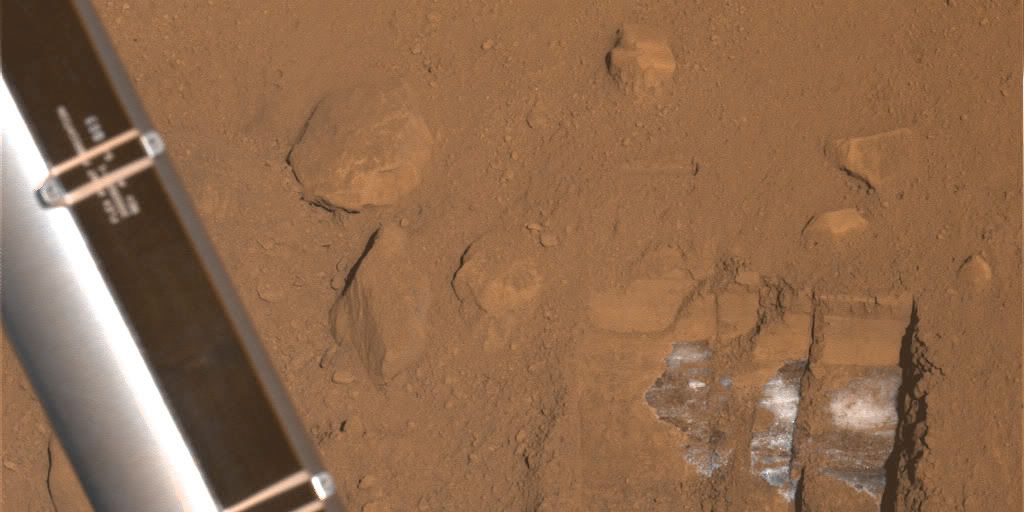
Non-overexposed glimpse of the bright stuff and dumped soil:

Phil Stooke
Jun 15 2008, 08:08 PM
Here's a polar pan of one of the cylindrical mosaics of RAC images that have been appearing on the Phoenix mosaics pages.
Phil
Click to view attachment
jekbradbury
Jun 15 2008, 08:12 PM
The colorization there is just a GIMP compose of these three images:
http://www.met.tamu.edu/mars/i/SS020EFF897...9_12A10RAM1.jpghttp://www.met.tamu.edu/mars/i/SS020EFF897...3_12A10RBM1.jpghttp://www.met.tamu.edu/mars/i/SS020EFF897...4_12A10RCM1.jpgand these three:
http://www.met.tamu.edu/mars/i/SS020EFF897...6_12A20RAM1.jpghttp://www.met.tamu.edu/mars/i/SS020EFF897...7_12A20RBM1.jpghttp://www.met.tamu.edu/mars/i/SS020EFF897...8_12A20RCM1.jpgwith a curves stretch applied to the first and then a lot of color fudging to get the second to equal. The mosaicing was really just trial and error. As to why it might look more ice-like than others, I tried to get as much contrast out of the ice by stretching that part of the range.
teck
Jun 15 2008, 09:13 PM
QUOTE (um3k @ Jun 15 2008, 12:27 PM)

To make color images from the RAC, you have to match the levels of the color-LED images and the no-LED image, subtract the no-LED image from the color-LED images, and then combine the color-LED image. Sometimes this just isn't possible without calibration data (or even with it!).
I have tried this method, but it does not work for the set of images lg_5206..7..8..9.jpg. I think this is due to the saturation of the images from the overexpose scoup in the upper right corner. I would like to see this image in color . It might revealed if this is ice or not !

fredk
Jun 15 2008, 10:12 PM
I think the problem with those Snow Queen images is that the RAC couldn't get very close to the target (ice/substrate), so the illumination is dominated by the ambient light rather than the LEDs. I'd think that to have any hope of extracting colour from them you'd need the raw images.
Anyway, as we expand the trench system we'll soon have much better SSI imagery of the white stuff...
jekbradbury
Jun 15 2008, 10:18 PM
The range of the red, green, and blue LEDs on the RAC is quite poor. They are mainly intended for the images of samples already in the scoop, which has less ambient illumination and is about ten times closer. However, this data may still be sufficient to colorize the image IF we can get non-jpeg and/or >8bits/channel images. As far as I know, these are not available to the public.
EDIT: Beaten to it!
mike
Jun 16 2008, 01:00 AM
Not available to the public..? Why?
fredk
Jun 16 2008, 01:10 AM
jmknapp
Jun 16 2008, 01:43 AM
If the bright stuff is ice, could someone explain how the geology works? I.e., if it's permafrost isn't it weird that it's only overlain by a couple inches of very loose dirt and some smallish rocks (presumably remnants of some impact)? If it's not permafrost but seasonal deposits, then how does it get covered by said dirt and rocks?
mike
Jun 16 2008, 02:18 AM
Ah, so the RGB scoop images will be released eventually.. they must think it holds some really good science.
JRehling
Jun 16 2008, 05:35 AM
I think models going back many years predicted (not necessarily as scripture, mind you) the idea of ice covered by slight amounts of soil.
Basically, permafrost occurs where the annual average temperature is cold enough to keep H2O solid without sublimation. As on any other solid body, the temperature will vary most at the surface, and vary less so the deeper beneath the surface. If the top few centimeters see enough variation for ice to melt or sublimate at the very warmest moment of the year, then they will end up ice-free. At whatever depth the variation is too slight for the annual maximum to melt/sublimate the ice, that's where the ice will collect.
If you scraped all the dust/rocks away, and left a big ice sheet here, it would just be a matter of time before wind blew a thin coat of dust on top, making the albedo about 0.15 instead of 0.8. Then the ice within a few cm of that new surface would sublimate over the years, lowering the surface but leaving increasing deposits of dust/rock on top until the equilibrium were restored anew.
The same thing should exist, qualitatively speaking, down to much lower latitudes, too, but with a deeper layer of dust and rock. And at high enough latitudes, you get to the point where the annual surface maximum is too cold to disrupt the ice, and that's where you have the small permanent H2O icecap. This is just a midpoint on that continuum. From the morphology of craters, it seems that only at very low latitudes is there rock "all the way down" with no ice layer.
Skyrunner
Jun 16 2008, 08:01 AM
QUOTE (James Sorenson @ Jun 15 2008, 04:00 AM)
Does anyone know when the first use of this usefull instrument will be used?, or have they used it allready?.
Here is your answer:
Sol 21: Telltale coordinated with TECP - CalibrationMan I love the descriptions on Marks page
No surface touching with the TECP yet but wind speed measurement.
Skyrunner
Jun 16 2008, 08:41 AM
QUOTE (James Sorenson @ Jun 15 2008, 04:00 AM)
I got an idea, is there any heaters in the scoop?, if there is why not press the scoop down on the possible ice and use the RAC to see if any of the ice melts?.
There are film heaters on the motors, gearbox and output. The wrist motor needs to be heated a lot longer before use than the azimuth, elevation and elbow joints. The heaters aren't that powerful: only 10 Watts or so. But still inside temperatures could go up to 30 deg C . A thermostat prevents temperatures above 85 deg C but a case was tested in which the wrist thermostat was stuck in the "on" position and it still operated fine (without continues using it off course).
There isn't much thermal insulation on the RA to prevent tangling of the wiring so the wrist actuator will lose some heat by radiation, natural convection and conduction. I have no idea about how much conduction heat loss there is when the scoop (or any other part) touches the soil. I don't expect (it would greatly surprise me) them to use the scoop to warm the soil a bit...at least not before they now much conduction loss they can expect. The TECP can help answer that question though.
EDIT: it just hit me that the TECP actually heats the soil to measure thermal properties. So instead of using the scoop they can just use the TECP for it's intended use and get some pre and post touch images with the RAC.
jmknapp
Jun 16 2008, 12:12 PM
QUOTE (JRehling @ Jun 16 2008, 12:35 AM)
If you scraped all the dust/rocks away, and left a big ice sheet here, it would just be a matter of time before wind blew a thin coat of dust on top, making the albedo about 0.15 instead of 0.8. Then the ice within a few cm of that new surface would sublimate over the years, lowering the surface but leaving increasing deposits of dust/rock on top until the equilibrium were restored anew.
With a supposed equilibrium at just a few cm of loose dirt, it would seem that the temperature must drop very quickly in just that short distance if the ice is to be stable. If the max air temperature measured by the lander is -26C (high for Sol 17), then would it be logical that the max temperature at the surface is well above that?
Might that it's not ice be the simpler explanation in this case?
Or maybe the ice isn't stable, but is disappearing on a geologic time frame (global Mars warming), & the dirt layer is still building up?
teck
Jun 16 2008, 01:10 PM
I did a pseudo color image by adjusting the gamma value of each gray-scale photos.
Click to view attachmentNot much help there

algorimancer
Jun 16 2008, 02:28 PM
Differentiating this whitish material between ice and salt seems a bit difficult from the images - presumably both would be nearly white. If we assume that ice is more likely to be distinctly translucent, then the RAC could be used to capture a close stereo pair (ideally in color) focused on the white material, and if we can see into the material then it would presumably be more likely to be ice. Seems like a simple thing to try.
ugordan
Jun 16 2008, 03:43 PM
Sol 20 red + blue w/ a synthetic green view of the trenches (pre-sol 20 dig), again nicely exposed due to shiny robotic arm. Local time 10:45.

The blue colored variations in the white stuff are probably (?) processing artifacts (it's likely more grayish judging by official composites), but this image sure gives me the feeling of the scoop scraping up something hard.
slinted
Jun 16 2008, 03:47 PM
Great job ugordon! That image shows both the dark borders and the bright spots of the materials very well.
Stu
Jun 16 2008, 03:54 PM
The "rock pile" is really catching my eye. It shows just how busy Phoenix is now... scooping up, dropping, extending trenches, exposing might-be-ice...
Click to view attachment
ahecht
Jun 16 2008, 03:58 PM
QUOTE (jmknapp @ Jun 16 2008, 08:12 AM)
With a supposed equilibrium at just a few cm of loose dirt, it would seem that the temperature must drop very quickly in just that short distance if the ice is to be stable. If the max air temperature measured by the lander is -26C (high for Sol 17), then would it be logical that the max temperature at the surface is well above that?
Might that it's not ice be the simpler explanation in this case?
Or maybe the ice isn't stable, but is disappearing on a geologic time frame (global Mars warming), & the dirt layer is still building up?
You're thinking about temperature from an earth-centric point of view. On Earth, with a thick atmosphere, most heat transfer is done via convection, followed by conduction, and lastly followed by radiation. On Mars, however, the thin atmospher means that convection and conduction are quite minimal compared with radiation. A prime example of this is the
ice that was found on the moon -- the fact that some craters were perpetually in shadow created enough of a temperature difference to prevent ice from sublimating.
On Mars the soil is light and fluffy (as we saw when Yeti was created), and there is little atmosphere between the grains, so the ice would be well insulated from conductive heating from the surface. There would be little (if any) convection, and the soil is opaque enough to prevent radiation. Therefore, the gradient in temperature could be HUGE after digging down only a few centimeters.
James Sorenson
Jun 16 2008, 04:54 PM
QUOTE (Skyrunner @ Jun 16 2008, 12:41 AM)
EDIT: it just hit me that the TECP actually heats the soil to measure thermal properties. So instead of using the scoop they can just use the TECP for it's intended use and get some pre and post touch images with the RAC.
Awesome!!. I hope they have this planned using the RAC to take a sequenced movie of heating the ice.
ahecht, if that was in responce to my question, I was talking about placing the heated scoop on solid ice, not soil.
centsworth_II
Jun 16 2008, 05:51 PM
I think the TECP is designed to measure heat flow through ice, not melt it. I wonder if there is any intention that the TECP experiments would result in the production of even a microscopic amount of water at the probe tips.
jmknapp
Jun 16 2008, 06:03 PM
QUOTE (ahecht @ Jun 16 2008, 10:58 AM)
Therefore, the gradient in temperature could be HUGE after digging down only a few centimeters.
Interesting... thanks. BTW, are you anything to Dr. Michael Hecht, co-investigator on the MECA team?
ahecht
Jun 16 2008, 06:04 PM
James, I was responing to jmknapp. I could've sworn I had a quote in my post, but it didn't show up originally.
JRehling
Jun 16 2008, 07:14 PM
QUOTE (jmknapp @ Jun 16 2008, 05:12 AM)
With a supposed equilibrium at just a few cm of loose dirt, it would seem that the temperature must drop very quickly in just that short distance if the ice is to be stable. If the max air temperature measured by the lander is -26C (high for Sol 17), then would it be logical that the max temperature at the surface is well above that?
I may be comparing apples and oranges, but I think the maximum reported "airborne" temperature from Pathfinder was -10C, at an altitude of 25 cm, and the maximum at Viking 1 was -17 C, at 1.5 meters altitude. But surface temperatures have been estimated as 27 C (Viking). That would naively imply a difference of about 37 degrees K between 25 cm and the solid surface. I'm not sure of the error bars on the two observations, but it seems like a real difference exists. And it would make sense, since dark ground should trap a lot of heat and thin, clearish air would trap little either in the form of direct sunlight or that irradiated up from the ground.
As for the subsurface changes, we could look quickly at a terrestrial analogue. A cave on Prince of Wales Island has a reported constant temperature of about 5 C at probably just a few meters depth. The surface maximum is probably about 35 C. (Over geological time, maybe 40 C or a bit higher?) So that indicates somewhere in the neighborhood of 5 to 15 degrees K per meter for the difference between surface and subsurface temperatures. I think we could expect some rather sharp boundaries because there'd be little variation other than the annual/daily cycle a few centimeters down. Wherever conditions meet the chemical property in question (phase change), that boundary should be pretty well defined and abrupt.
Stu
Jun 16 2008, 07:17 PM
Thought I'd try something a bit different for my latest poem... hope a few of you like it
Click to view attachmentI've put the
text version up on my poetry blog for anyone who wants the plain version.
fredk
Jun 16 2008, 08:13 PM
During today's press briefing they mentioned that they want to monitor the bright clump visible in this sol 19 image:
Click to view attachmentBut that clump is already gone in the sol 20 images, presumably due to further trenching - see slinted's animation
in this post.
David
Jun 17 2008, 12:51 AM
QUOTE (fredk @ Jun 16 2008, 08:13 PM)
But that clump is already gone in the sol 20 images, presumably due to further trenching - see slinted's animation
Perhaps it tumbled into the deeper end of the trench, and is still visible?
jmknapp
Jun 17 2008, 02:36 PM
QUOTE (JRehling @ Jun 16 2008, 03:14 PM)
I think we could expect some rather sharp boundaries because there'd be little variation other than the annual/daily cycle a few centimeters down. Wherever conditions meet the chemical property in question (phase change), that boundary should be pretty well defined and abrupt.
In that vein, this chart from "The presence and stability of ground ice in the southern hemisphere of Mars" (Icarus 169 (2004) 324340) is of interest:
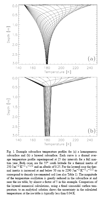
So those charts show the temperature at depth at about 180K (-93C), with the diurnal range narrowing in a short distance for the "layered" case, which in this case assumed a 50cm depth of ice-free soil over the ice table.
fredk
Jun 17 2008, 03:18 PM
QUOTE (fredk @ Jun 16 2008, 08:13 PM)
But that clump is already gone in the sol 20 images
Or, as
Mark Lemmon puts it,
QUOTE
Sol 019 More digging, dislodge interesting fragment
QUOTE
Sol 020 Continue dodo trenching, wantonly destroy fragment

helvick
Jun 17 2008, 03:24 PM
That was exactly what I was thinking. I wonder did this happen because they are pushing an aggressive schedule (which they need to we're ~25% of the way into the primary mission already) and didn't have time to react to this interesting nugget or did they see it and decide to proceed in any case?
This is a "lo-fi" version of our main content. To view the full version with more information, formatting and images, please
click here.