Yes, great post O doug,
This can lead also to "Mission success" requierements.
BTW, does anybody know what are Mission sucesses requirements for Phoenix ?
Full Version: Robot Arm - Observations and Excavations
QUOTE (climber @ Jun 13 2008, 01:01 PM) 
This can lead also to "Mission success" requierements.
BTW, does anybody know what are Mission sucesses requirements for Phoenix ?
BTW, does anybody know what are Mission sucesses requirements for Phoenix ?
I found it....
Phoenix mission sucess criteria
QUOTE (climber @ Jun 13 2008, 03:01 PM)
BTW, does anybody know what are Mission sucesses requirements for Phoenix ?
Minimum Mission Success Criteria
To achieve minimum success, the Phoenix Project shall:
- Land successfully on the surface of Mars and achieve a power safe state.
- Acquire a 120 degree monochromatic panorama of the landing site.
- Provide samples of the surface soil as well as samples from one depth beneath the surface to either TEGA or MECA wet chemistry.
- If TEGA, it shall analyze at least 2 soil samples to create a profile of H2O (in the form of hydrated minerals, adsorbed water, or possibly ice at the deepest level) and mineral abundances near the surface. It shall also analyze an atmospheric sample in its mass spectrometer.
- If MECA, it shall analyze the wet chemistry of 2 soil samples.
- Document all non-atmospheric samples and their collection locations with images.
Full Mission Success Criteria
In order to be fully successful, the Phoenix Project shall:
- Land successfully on the surface of Mars and achieve a power safe state.
- Acquire a true color (RGB), 360° panorama of the landing site.
- Obtain calibrated optical spectra of at least 3 locations that include both rocks and soil.
- Provide temperature and pressure measurements throughout landed surface operations at a frequency that determines key atmospheric properties.
- Provide samples of the surface soil as well as samples from two depths beneath the surface to both TEGA and MECA.
- Use TEGA to analyze at least 3 soil samples to create a profile of H2O (in the form of hydrated minerals, adsorbed water, or possibly ice at the deepest level) and mineral abundances near the surface. It shall also analyze an atmospheric sample in its mass spectrometer.
- Use MECA to analyze the wet chemistry of at least 3 soil samples. It shall also analyze 3 additional samples in its microscopy station.
- Document all 9 non-atmospheric samples and their collection locations (before and after sampling) with images.
So, does that mean full mission success can be achieved without actually reaching, sampling and analyzing solid ice?
Brian
Brian
QUOTE (BrianL @ Jun 13 2008, 11:26 AM)
So, does that mean full mission success can be achieved without actually reaching, sampling and analyzing solid ice?
It seems to me that mission success should be based analysis of the landing site, whatever the results of that analysis are. Also, let us hope that there is no layer of solid ice, especially near the surface, as that would mark the end of the dig, depth-wise anyway.
I want them to dig a MASSIVE trench !! 
Here's an animated gif of the digging. 21 frames spanning almost 2 hours. It's half resolution because the full res was too large to upload anywhere (9 meg). The overexposed part of the sequence covers 50 minutes and during that time no visible change in the white stuff can be seen.
Link to animation here
And an anaglyph of the resulting trenches:

Link to animation here
And an anaglyph of the resulting trenches:

Thanks for the animation and anaglyph. It appears to me that the bright "ice-like" surface exposed at the bottom of the trenches is not flat - there is relief to it. This is most clear on the right side trench.
I think we can expect more time-lapse trench images like this. On a recent press briefing there was an interesting comment from Smith I believe, who said that there was quite a discussion amongst the team about whether we were seeing true changes in the bright "ice" or whether it was just due to changes in illumination (phase) angle.
I guess this doesn't really fit in "RAC - Lander and Under-side observations" - perhaps we need a thread dedicated to trenching?
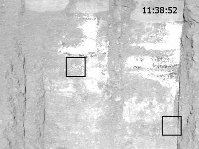
To continue on the animation I posted and seeing the Phoenix team today alluded at hints of change of white stuff in time-lapse frames (change not necessarily illumination-related), here's a crop of the animation with two patches definitely fading out over time. Phase angle effect? It doesn't look that way to me, the neighbouring areas don't show nearly as much dependance. There's a frame each 3.5 minutes or so, except a 20 minute gap between 11:45 and 12:05. During this time the two spots change most prominently. There are also some smaller specks that appear to fade out, but they're not very conclusive. The rest of the bright stuff appears to not change at all or change very little.
Ice particles sublimating? Any thoughts on this?

Ice particles sublimating? Any thoughts on this?
At the average ambient temperatures we expect sublimation to be quite slow. This might be accelerated by the action of sunlight shining on a dark bed of soil with a white ice particle sitting on top (if it is).
On another note, it seems remarkable that the ice could be just under the surface in such a wide area, yet there are no outcrops anywhere.
On yet another note (as I mentioned in another thread), I wonder if Peter Smith or anyone has commented on the "Holy Cow" image beyond what was briefly mentioned at today's press conference? It would be interesting to see how they would describe this image in front of an audience.
One answer as to why the ice would be nowhere exposed but everywhere covered by a thin layer of regolith is, of course, that the exposed ice has sublimated. I guess you need to be old enough -- I am 59 -- to remember stories of how ice covered with saw dust could last a remarkably long time. Gad, watching that trench being dug is some way cool stuff (pun intended)!
> guess you need to be old enough -- I am 59 -- to remember stories of how ice covered with saw dust could last a remarkably long time.
That is likely and accurate observation. The regolith, being partially aeolian, may have a "fairy castle" structure with a thermal conductivity approaching zero so even a few centimeters would allow possible temperatures to remain below the sublimation point of dihydrogen oxide.
I seem to recall a temperature/etc/ probe on the arm, so ew can expect temperature data soon enough.
--Bill
QUOTE (ugordan @ Jun 13 2008, 10:57 PM)
here's a crop of the animation with two patches definitely fading out over time. Phase angle effect?
Thanks again for this, this is interesting. I would guess we are seeing a phase angle effect (perhaps the extreme case of this, specular reflection). I say this because there are definitely small patches that get brighter over the series. I've circled one in the attached frame:
Click to view attachment
On a related note, I think I wrote this before, but we've now exposed quite a bit of the "substrate" and with each dig we haven't seen much in the way of loose powdery white stuff moved around by the scoop (unlike the salts exposed by Spirit). Also, Smith mentioned today that the scoop appears to be "bouncing" along the bottom of the trench, as if along a hard surface. So my question: is there any viable scenario in which the "substrate" is salt, but is hard rather than loose and powdery?
Indeed, I had brought this up in an earlier post: if the abundance of water is so high and the temperatures so low, then why wouldn't you expect the subsurface be just a massive block of ice, thus impenetrable by the scoop.
The response was given that salts would make the ice chunky, well-gardened.
The response was given that salts would make the ice chunky, well-gardened.
QUOTE (fredk @ Jun 13 2008, 05:09 PM)
... So my question: is there any viable scenario in which the "substrate" is salt, but is hard rather than loose and powdery?
I agree we're probably looking at ice, but the answer is basically the same whether it's ice or salt. In either case you have to consider a role for liquid water or brine.
In order to change powdery snow or frost into solid ice, you have to compact and recrystallize it, so as to eliminate air. This process is greatly facilitated if there is at least some liquid water on grain boundaries, so that the ice can dissolve and reprecipitate into larger crystals, expelling the air. (This recrystallization process is analogous to metamorphism of rocks such as limestone or sandstone.) The ice may start out as a filling between mineral grains (i.e., permafrost), but generally at least some of it will separate, again owing to recrystallization (and flowage), into zones or pods of pure ice, or perhaps into veins. The same sort of maturation/segregation process presumably is involved in the formation of ice polygons (w.r.t. which I claim no special expertise). If massive ice formation happens on a slope, and involves enough ice, then the ice starts to move, and you have a glacier.
The above process might appear to be limited to temperatures above 0C (273K) for pure ice and its meltwater, but could conceivably continue to temperatures as low as 220K or so if there were minor amounts of windblown chloride-rich salts mixed in. In that case the grain-boundary liquid could be a concentrated chloride brine, similar to those found beneath the surface of some permanently frozen Antarctic lakes, and the temperature range available overlaps the range measured by Phoenix (as discussed in other posts). Like air, the brine would eventually get squeezed out, ideally downwards, being denser than ice and able to flow. I discussed this idea in papers with Paul Knauth in 2002 and 2003.
If instead the substrate starts out as powdery efflorescent or wind-blown salt crystals, you similarly need at least some liquid water or brine along grain boundaries in order that the salt crystals can dissolve and reprecipitate (recrystallize) to eliminate air. In the case of salt, this liquid is almost certain to be a concentrated (saturated) brine, stable over the same possible temperature range as discussed above (assuming it is chloride rich - sulfate salts exhibit very little freezing point depression). The recrystallization should occur much faster for salts that are relatively soluble (e.g., chloride salts and magnesium sulfates) than for salts that are relatively insoluble (e.g., gypsum, a calcium sulfate). (This effect gives you one explanation for why only the least soluble common salt, gypsum, occurs in dunes - it doesn't recrystallize before the wind plucks it.) As with ice, salt recrystallization and migration could yield separate pods or zones or layers of relatively pure salt, as well as salt filling interstices between other mineral grains (a "saltcrete"). In a frozen recrystallized system involving ice, salts, and brines you ideally might end up with a "brine sandwich" involving less dense ice on top, a thin zone of concentrated (eutectic) brine, and denser precipitated salts beneath. Cooling below 220 K should cause the intermediate brine zone to freeze (crystallize) into a mixture of ice (above) and salts (below). These ideas are likewise discussed in our 2002 and 2003 papers (which were inspired by the "young gully" phenomenon).
The important point is that if there are hard layered zones of recrystallized salt at the landing site, they should underlie a thick zone of less dense ice (if brine was involved in their recrystallization, at least). That's one reason that I suspect the hard, bright patches currently under discussion are recrystallized ice rather than salt. Nevertheless, minor salt may have had an important role in allowing the ice to recrystallize under subfreezing conditions (thus making the massive ice extremely difficult to scrape).
Inasmuch as I'm not a specialist on permafrost, and have only been to Antarctica once, someone else may be kind enough to give you a more accurate (and hopefully much shorter) answer.
-- HDP Don
QUOTE (centsworth_II @ Jun 13 2008, 09:33 AM)
... Also, let us hope that there is no layer of solid ice, especially near the surface, as that would mark the end of the dig, depth-wise anyway.
Interestingly, it was suggested in today's briefing that they might "lay waste" to their entire "national park system" to expose the topography of the purported ice surface. If they can't dig anywhere deeply, strip-mining the area to the basement "rock" is a project I can support. 
Just for fun, I noticed that the Phoenix SSI is doing its visual color filtering with the right camera, and I realized that we might be able to produce sort of semi-colored anaglyphs with certain image sets. I'm not very good at color balancing false color images to make them appear as "approximate true color," so I used a color (RABC) image released today by the Phoenix team for the right half of this anaglyph, and the L1 grayscale for the left half. This is of the Dodo and Goldilocks trenches.
Click to view attachment
I use red/cyan glasses to view anaglyphs, which allow some red, blue, and green information to reach my brain from an image like this, albeit via different eyes. That's why I think this anaglyph appears to me in somewhat muted (rather than vivid) colors. I am curious to hear how it might appear to someone using red/blue glasses, or other filter pairs.
Don, that was very interesting and informative; thanks!
Question: Although I know you're not a specialist in such matters, what effect would the ambient temperature, the low atmospheric pressure, and the fact that the material discussed is (barely) subsurface have on H2O phase states?
I get the feeling that liquid water in this region is an impossibility unless it's WAY underground, and unless water can rapidly sublimate and refreeze in an amorphous state in these conditions I'm having a hard time understanding why it would exist in any form other then as a stratum or as a big chunk of same like Holy Cow might be; basically, as a discrete mineral.
QUOTE (dvandorn @ Jun 13 2008, 01:07 AM)
I will point out that tests to make general-to-specific characterizations of large, complex systems don't lend themselves well to double-blind testing concepts...
... but I'm not coming up with any good ideas on how to change the process to reduce the Rosenthal effect.
... but I'm not coming up with any good ideas on how to change the process to reduce the Rosenthal effect.
In keeping with those who have already commented, I think your post provides an excellent summary of the practical impossibility of eliminating prior expectations in planetary missions. My only quibble is that most of it deals with obtaining funding plus experiment and hardware design (something for which NASA is justifiably world-famous) rather than with the psychological problem of how best to interpret the observations, and then how best to interpret them to the media (which have their own expectations). I think we agree that the present system just might have problems in this regard. A simple systemic recognition of the Rosenthal effect, and its potential pitfalls, might be a start (in case the "canals" and "face on Mars" don't provide enough of a cautionary note - ugh).
It should be interesting to see how NASA deals with organic matter, if any is found.
-- HDP Don
QUOTE (nprev @ Jun 13 2008, 10:06 PM)
...Question: Although I know you're not a specialist in such matters, what effect would the ambient temperature, the low atmospheric pressure, and the fact that the material discussed is (barely) subsurface have on H2O phase states? ...
Thank you. Actually, I *am* supposed to be a specialist in phase diagrams, or at least I teach about them. My best answer without drawing any would be that at these low ambient temperatures, for concentrated brines, the low atmospheric pressure would not be much of a factor, especially in the shallow subsurface, when we're just talking about grain boundary films (i.e., moisture). The reason is that such syrupy brines, in addition to having a greatly lowered freezing temperature, also have a greatly lowered vapor pressure. This has been discussed in prior posts, I believe (probably dealing with gullies). Like you, I'd worry more about the temperature than about the pressure - we should be getting close to the freezing limit for even the briniest of liquids, so close to the poles (unless ice recrystallization occurred in a prior climate regime). On the other hand, I don't know of a better way to encourage recrystallization. Simple squeezing under pressure might suffice, but that would imply considerable erosion/sublimation since the ice originally recrystallized. Possible, I suppose. (But would we see polygons then?)
Repeat: I'm not a permafrost specialist. I live in Phoenix, Arizona, where it sometimes gets up to 122F (50C). I can tell you about the chemical theory while I'm frying eggs on the sidewalk, but that's about it.
-- HDP Don
Accumulating thick and "solid" ice...
One thing we're perhaps tripping over here is timescales on Mars, compared to Earth, and the role of vapour to solid transitions. On Earth, almost all ice is formed either from accumulated snowpack, or from frozen water. The accumulated snowpack (snow->firn->ice) is quite well understood and DOES have an important role for boundary-layer water films in facilitating recrystallisation. On Mars, we *may* be dealing with a different system where solid-state dcrystal growth occurs direct from the vapour phase.
Over many annual, decadal, millenial cycles, the ice surface may sublime away, or accrete, essentially ALWAYS in the solid state. On Earth, we grow polycrystalline diamonds by this method from carbon-rich high-temperature vapours.
The mechansims for ice and dust segregation on Mars - whether they involve ephemeral liquids or not - are most likely to be closest to processes in the very cold dry Antarctic valleys, but remember, that Antarctica is so hot and wet and high-pressure compared to Mars that it is unlikely to be a direct analogue. We may need to extrapolate another couple of orders of magnitude!
The ice-sheets of Antarctica are highly dynamic on a time-scale of tens or hundreds of thousands of years. Reports of million-year ages for deposits overlying ice in the Antarctic dry valleys are still uncertain, but even if they are, most parts of Mars have surface ages of tens to hundreds of millions of years and are much older. Something that is insignificant on Earth *could* be important on Mars.
I like one aspect of Don's analysis - he suggests that any liquids that might form by interacting with salts have probably *already* done so and *already* left the scene.
People often argue that areas like the base of Hellas are warmer and more liquid-friendly than other areas of Mars, but let's look how that plays-out on earth. The Sahara Desert is one of the hottest areas on Earth (or a better analogue, the Taklimakan depression in Western China). These areas become searingly hot, by earth standards. All the near-surface water is baked out, blown away in the wind, and finally falls as precipitation in distant areas, perhaps even as snow in the mountains.
On Mars, Hellas is the Taklimakan depression. it's hot as hell (by Martian standards) and any casual H2O will be vapourised, advected by winds, and will exit the basin, ultimately ending up as precipitation in the cold-spots of Mars like the polecaps (or equatorial icecaps, in high-obliquity times). Remember that we KNOW that large amounts of material have been removed from hellas, by the exposed weathering patterns of e.g. the honeycomb terrain. Over the millennia, hundreds of metres of sediment have been blown away by the winds, and all the associated water is probably long-gone.
Phoenix in in area where ice is stable. Anything that you can engineer to generate liquid water there would have done it thousands of years ago and, as Don suggests, leached down into the subsurface.
We're likely looking at a volatile-poor residual crust of ice, which has been frequently sublimed and re-accreted, and processed to a very pure state.
But let's see what the ovens have to say...
QUOTE (SickNick @ Jun 13 2008, 11:57 PM)
...On Mars, we *may* be dealing with a different system where solid-state crystal growth occurs direct from the vapour phase...
...
...We're likely looking at a volatile-poor residual crust of ice, which has been frequently sublimed and re-accreted, and processed to a very pure state...
...
...We're likely looking at a volatile-poor residual crust of ice, which has been frequently sublimed and re-accreted, and processed to a very pure state...
Hi Nick, Thanks for noticing I was floundering. I like your suggestion of direct ice growth from the vapor phase, plus repeated daily/seasonal cycling. Lets you do it as cold as you like, for as long as you like, without any special pleading regarding salts or brines or changing climates or deep burial. Shows that my trip to Antarctica may have hurt my Mars intuition far more than it helped (good thing I wasn't there long enough to make me an expert
 ). Occam would be proud of you!
-- HDP Don
QUOTE (CosmicRocker @ Jun 14 2008, 12:03 AM)
[...] I am curious to hear how it might appear to someone using red/blue glasses, or other filter pairs.
Looks great to me with plenty of color detail using the more red/blue "Sky & Telescope" cardboard glasses; very nice job on that anaglyph. I'm sure that was quite a bit of work making everything line up right, but I hope you do more of them!
Airbag
Is there a possibility that during high obliquity times we would get continuous sunlight on the polar region and actually make it up to the melting point? At least presently, the pressure is enough for liquid water to exist at this elevation.
I recall that in the book "The New Solar System" there were some interesting diagrams of stability of ice as a function of latitude and depth. The Mars chapter in several of the editions was written by Michael Carr. The diagrams would need some modification perhaps based on the Odyssey observations. I'm also unsure they would account for the variable obliquity over geological (areological) time.
I recall that in the book "The New Solar System" there were some interesting diagrams of stability of ice as a function of latitude and depth. The Mars chapter in several of the editions was written by Michael Carr. The diagrams would need some modification perhaps based on the Odyssey observations. I'm also unsure they would account for the variable obliquity over geological (areological) time.
QUOTE (scalbers @ Jun 15 2008, 12:57 AM)
Is there a possibility that during high obliquity times we would get continuous sunlight on the polar region and actually make it up to the melting point? At least presently, the pressure is enough for liquid water to exist at this elevation.
Oh, sure, if you took Mars today, and twisted it with a space-time vortex and tomorrow it was in high obliquity. No problem.
The issue is, it takes tens of thousands of years to move from one state to the other, and the near-surface ices have plenty of time to advance or retreat, and end up at a depth where vapour equilibrium dominates, and there is not then any liquid, under the conditions of the day.
Remember we're dealing with a DYNAMIC equilibroum - things change. TO coin a phrase - "Mars climate changes in a way that *always* frustrates one's preferred model"
I can't *prove* that there is never, ever, liquid water on Mars, but the ESA mineralogy results show that there has been *almost never* liquid water on Mars. A Mars model that has thin liquid water films TODAY at any random location is precluded.
I think I did imply in my post that the obliquity varies over long periods of time  Interesting point that the dynamic equlibrium can change rapidly enough in response to this. How close to the surface would this be true for?
I thought I did hear Peter Smith suggest they could look for organic chemistry in the ice based on the possibility of past melting in the "recent" (though not that recent) times of high obliquity. Perhaps I misinterpreted what I had heard. I guess as you say earlier we'll let the ovens speak.
Steve
Interesting point that the dynamic equlibrium can change rapidly enough in response to this. How close to the surface would this be true for?I thought I did hear Peter Smith suggest they could look for organic chemistry in the ice based on the possibility of past melting in the "recent" (though not that recent) times of high obliquity. Perhaps I misinterpreted what I had heard. I guess as you say earlier we'll let the ovens speak.
Steve
QUOTE
On Mars, we *may* be dealing with a different system where solid-state dcrystal growth occurs direct from the vapour phase.
Nick I don't fault your logic, but can we make water crystals from vapour with no liquid stage, in simulated mars conditions, here on earth? I was under the impression that as a crystal forms from vapour below 273 kelvin but above roughly 180 kelvin there is a nanometers thick liquid layer over its surface kept liquid not by impurities but by pressure from van der waals forces. I hope you don't take this as a nitpick, I'm just trying to be sure of what you mean.
Disregarding the possibility of a thin liquid film, we can get ice crystals condensing directly from water vapor when it's well below freezing on earth. If you've seen an "ice fog" or ice crystals floating in the air that produce sun pillars or streetlight pillars, this can happen without a supporting cloud of supercooled liquid water droplets.
Frost would be another example of going directly from vapor to ice crystals. I would assume this could also be possible under simulated Mars conditions.
Steve
Frost would be another example of going directly from vapor to ice crystals. I would assume this could also be possible under simulated Mars conditions.
Steve
Hey -- we can nitpick Nick's and Don's theories on the emplacement processes for this ice layer that we seem to be literally unearthing, here. But at least they're dealing with potential deposition and emplacement processes.
I think it's important to have some well-nitpicked theories for emplacement processes as we start looking at this ice layer in detail. As much as models can put blinders on investigators, they are also incalculably helpful in interpreting empirical results.
In my mind, each of the observations we've been making on this apparent ice layer bring up questions on how such a layer could exist during the present day. And those questions can only be answered in the context of a model of ice deposition, sublimation and maintenance.
I'm looking forward to hearing more from Nick, Don and all others on how our observations fit with various ice emplacement models.
-the other Doug
QUOTE (fredk @ Jun 14 2008, 02:09 AM)
I would guess we are seeing a phase angle effect (perhaps the extreme case of this, specular reflection). I say this because there are definitely small patches that get brighter over the series.
Does this make a more convincing case? Obviously there's been some digging in Baby Bear, but Dodo is intact as far as I can tell. The local time is the same to within 2 minutes so no phase angle effects this time. Same filter in both shots; R2 (blue).
Click to view attachment
QUOTE (dvandorn @ Jun 14 2008, 01:03 PM)
Hey -- we can nitpick Nick's and Don's theories on the emplacement processes for this ice layer that we seem to be literally unearthing, here.
If you're being literal, wouldn't it be "unmarsing"?
I was wondering when someone would say that! What I was getting at was whether or not Nick was suggesting the ice formed in a way that normally occurs at much lower temperatures, and if he is, why he thinks this would be the case? Crystal formation, is something I'm studying as part of my PhD so I was wondering if nick had some piece of knowledge on how the martian conditions affected the ice forming process.
EDIT: I changed some things for clarity.
What I was getting at was whether or not Nick was suggesting the ice formed in a way that normally occurs at much lower temperatures, and if he is, why he thinks this would be the case? Crystal formation, is something I'm studying as part of my PhD so I was wondering if nick had some piece of knowledge on how the martian conditions affected the ice forming process.EDIT: I changed some things for clarity.
QUOTE (ugordan @ Jun 14 2008, 05:35 PM)
Does this make a more convincing case?
Yes! This is extremely interesting. The differences in your latest gif are clearly not phase related - looking at frames on a single sol (either 18 or 19), you can compare the frame in your gif with frames taken a couple of minutes later or earlier on the same sol, and there are no significant chages (only specular reflection could have given changes that quickly).
As you say, the left side trench is largely untouched between your two frames, although there are a few new sprinkles towards the bottom. But for the most part, we must be seeing genuine changes here!
I'm very intrigued by the nature of the change. Generally, the "bright substrate" has become darker. But, the peripheral parts of the "bright substrate" have become very dark on sol 19 - in fact, they have become darker than the surrounding soil! I've highlighted a prominent darkened region on the sol 19 frame:
Click to view attachment
I've noticed these dark peripheral regions before, but I haven't read any discussion on them. Now we see clearly that they develop over time. What's going on here?
\begin{brazen, uncalled for speculation by a non-geologist}
Could this be darkening due to dampness? Ie soil warms in sun, warms adjacent ice, soil gets slightly damp.
\end{brazen, uncalled for speculation by a non-geologist}
As for obliquity- and other Milankovich-type changes, they are important here on Earth too, and pretty slow (the most important periodicities are 41,000 and 100,000 years). However they can still cause quite abrupt climatic changes, especially between glacial and interglacial conditions. These are apparently due to conditions passing a critical treshold and flipping rather suddenly from one semi-stable state to another. It seems to me that this could happen on Mars too. As a matter of fact the layered terrain at the poles rather suggests that it does.
Forgive me for interrupting this discussion of the images from people who are far more knowledgeable than I, but to a totally untrained eye, assuming that the white "stuff" is indeed water ice, the darker spots that have appeared look to me a lot like it's melted and that the soil is wet.
Let me state for the record that I'm not a chemist and know nothing about the behavior of water under different pressures and temperatures, or its properties once mixed with other substances. Just posting my thoughts here because sometimes an uninformed opinion can be a breath of fresh air. Maybe that's the case with this post, maybe not.
Though I realize that this may turn out not to be ice at all, it still *looks* like melt with some slight capillary spread.
I agree we should at least entertain the hypothesis of melting in the sunlight. Exactly how warm can a surface get when exposed to the sun at that location? The answer would vary depending on whether we assume glancing incidence (to a level surface), or normal incidence to an inclined surface.
We know that maximum air temperatures are about -30C. The ground (at least the darker component) can likely get somewhat warmer.
The atmospheric pressure is high enough to support liquid here. What a uniquely fascinating mission!
We know that maximum air temperatures are about -30C. The ground (at least the darker component) can likely get somewhat warmer.
The atmospheric pressure is high enough to support liquid here. What a uniquely fascinating mission!
I think the ground is usually about 15 degrees warmer than the air temperature, which would mean the ground is at -15 deg celcius, at a very rough guess. That's still to cold for pure water to melt, so unless the experiments show something in the ice which lowers the melting point either: its not melting it just looks a bit like it is, or that's not water ice, or the apparent darkening is some kind of camera artefact, or something else I haven't thought of...
Here's an interesting reference I found on another forum. It agrees with the 15C difference, but suggests the ground temperature can approach 0C.
http://www.lpi.usra.edu/meetings/7thmars2007/pdf/3147.pdf
(see upper right paragraph on the third page)
Elsewhere in the forum thread, it is suggested that polar regions can reach +10C ground temperature judging from early Earth based observations.
http://www.marsroverblog.com/discuss-70688...mperatures.html
Steve
That's an enticing thought Steve, but since we don't know if that even is ice yet (for sure), and we have no way of measuring ground temperature I think we're getting ahead of ourselves. Assuming it is ice I'd like to know why its formed a solid layer just beneath the surface, I'd read it was expected that ice deposited from vapour would simply fill the pores in the soil, implying processes involving liquid might displace the soil. How far down does the liquid formed by frost leaching travel before it hits temperatures cold enough to freeze it? I'm wondering if the solid layer could be the result of hundreds of thousands of years of tiny amounts of brine from frost leaching sinking into the soil? If it is cold and protected enough there it might have been there for a looong time.
For more background info on this I found an UMSF thread on Mars Odyssey THEMIS IR temperature measurements (of "skin" temperature). In some cases warm readings imply instrument noise or localized hot spots. In other cases, even the minimum values in the field of view are remarkably warm at high latitudes. Is this measurement correct?
THEMIS Image Data Page for I02967002.
CENTER_LATITUDE = 76.7838
CENTER_LONGITUDE = 128.354
MINIMUM_BRIGHTNESS_TEMPERATURE = 267.048
MAXIMUM_BRIGHTNESS_TEMPERATURE = 314.033
http://themis-data.asu.edu/img/I02967002
http://www.unmannedspaceflight.com/index.php?showtopic=1229
THEMIS Image Data Page for I02967002.
CENTER_LATITUDE = 76.7838
CENTER_LONGITUDE = 128.354
MINIMUM_BRIGHTNESS_TEMPERATURE = 267.048
MAXIMUM_BRIGHTNESS_TEMPERATURE = 314.033
http://themis-data.asu.edu/img/I02967002
http://www.unmannedspaceflight.com/index.php?showtopic=1229
That's a helluva knack for thread finding you've got there!  One of the threads mentions that the brightness temperature doesn't necessarily match directly with actual ground temperature, but if there's a close enough relationship between the two then water could have formed, and be stable over a narrow range of temperatures. The pressure seems high enough (barely but it is high enough). There's a lot of ifs to get past though, I'd only put it in the 'maybe' pile. If I had one.
One of the threads mentions that the brightness temperature doesn't necessarily match directly with actual ground temperature, but if there's a close enough relationship between the two then water could have formed, and be stable over a narrow range of temperatures. The pressure seems high enough (barely but it is high enough). There's a lot of ifs to get past though, I'd only put it in the 'maybe' pile. If I had one.
OK, at the risk of speculating some Earth based analogies to Mars, I think the difference between the brightness temperature and the extreme top layer of ground might be just a few degrees. Things that can throw this off would be surface emissivity and atmospheric effects.
I do see in the UMSF thread a mention that the warm readings of 300K are unusual with most readings in the 250s, so we could be looking at some sort of instrument anomaly in this isolated case. We'll have to look a bit closer at the data perhaps.
Here's another report based in part on Viking IRTM (Infra-red Thermal Mapper) data.
http://www.pubmedcentral.nih.gov/articlere...cgi?artid=30104
It suggests max temperatures at the surface (figure 1b) roughly 265-270K if I read the chart correctly, at least up to 60 degrees N latitude. So this seems overall like a close call.
QUOTE (marsbug @ Jun 14 2008, 02:04 PM)
That's an enticing thought Steve, but since we don't know if that even is ice yet (for sure), and we have no way of measuring ground temperature I think we're getting ahead of ourselves.
Correct me if im wrong, but I thought the TECP on the arm could messure the electrical propertys of the soil and also measure temperature?.
Greetings,
Yes James, I see in this reference the TECP can do a lot, even detecting the electrical properties of "unfrozen" water that is heated within a trench.
http://www.cosis.net/abstracts/EGU04/01134/EGU04-J-01134.pdf
I will speculate again on another consideration I've been thinking about. Given the shape of the trench, and the appearance of it being well illuminated, I wonder if there could be some reradiation of IR energy from the walls of the trench onto the floor? If so, this might give us a few extra degrees to work with. Think of standing next to a brick building on a warm sunny day.
Steve
Thought so, I read an artical saying that the TECP could also be used to measure the wind direction.
http://www.decagon.com/mars/info/GeneralTECPmeasurement.pdf
Does anyone know when the first use of this usefull instrument will be used?, or have they used it allready?.
I got an idea, is there any heaters in the scoop?, if there is why not press the scoop down on the possible ice and use the RAC to see if any of the ice melts?.
Love the crumbly texture and detail visible in the right hand trench...
I have downloaded some R G B images from the RAC. I do I combined them to get a color photo using GIMP?
If I used the regular compose tool, I still get BW images. I undertand that these are illuminated R G B shots and not filtered. If I compose from the SSI images, I get color photos.
If I used the regular compose tool, I still get BW images. I undertand that these are illuminated R G B shots and not filtered. If I compose from the SSI images, I get color photos.
To make color images from the RAC, you have to match the levels of the color-LED images and the no-LED image, subtract the no-LED image from the color-LED images, and then combine the color-LED image. Sometimes this just isn't possible without calibration data (or even with it!).
Here's a blink comparison of sol 18 and sol 19 dig sites for a little context. A much wider area of the 'bright stuff' has been exposed along the o'le Dodo trench. And please put no confidence in the colors for the bright areas. As I'm sure many of you have noticed, the raws are bled out pretty bad in the longer exposures.

(click through for animation)

(click through for animation)
QUOTE (James Sorenson @ Jun 14 2008, 09:00 PM)
Thought so, I read an artical saying that the TECP could also be used to measure the wind direction.
http://www.decagon.com/mars/info/GeneralTECPmeasurement.pdf
http://www.decagon.com/mars/info/GeneralTECPmeasurement.pdf
Just a note, the TECP measures wind velocity, the telltale (discussed elsewhere) indicates wind direction.
Steve M
This is a "lo-fi" version of our main content. To view the full version with more information, formatting and images, please click here.