tedstryk
May 14 2007, 03:58 PM
Here we are then...
 Full Resolution
DDAVIS
May 27 2007, 01:40 AM
In images 2 and 4 of the Zond sequence the Lunar horizon part of the photos are identical with no perspective change as one would expect from an actual orbital sequence. Only three of the images are thus part of a valid sequence.
I would love to have a full res color version of the 'Earthset' Zond image TASS released in B&W, which I saw and photographed at the Hansen Planetarium when I worked there.
Don
tedstryk
May 27 2007, 02:00 AM
It is actually image 2 that isn't a valid part of the sequence - I created it using image one and three in order to even up the time intervals.
Ant103
Jul 20 2007, 01:26 PM
It's not a whole Earth picture but it's of topicality (dust on Mars... dust on Earth) :
http://www.studiolentigo.net/upload/Poussi...ill2007-18h.jpg(taken yesterday à 6 A.M by MSG2)
climber
Jul 20 2007, 07:27 PM
QUOTE (Ant103 @ Jul 20 2007, 03:26 PM)

It's not a whole Earth picture but it's of topicality (dust on Mars... dust on Earth) :
il marche pas le lien


CAP-Team
Jul 20 2007, 08:53 PM
this link works

LivingNDixie
Jul 23 2007, 04:51 PM
This is one of my favorites, it makes a great wallpaper on your computer.
djellison
Jul 23 2007, 08:37 PM
That's just renered from the Blue Marble data set. Nice - but not real
Doug
MouseOnMars
Jul 23 2007, 11:13 PM
The Japanese GMS-5 satellite used to produce full disc images every half an hour. By the time I managed to construct a rather rough animation of full disc cloud movements their camera was failing (as you can see in the following animation).

(Click for larger)
mouseonmars
scalbers
Oct 9 2007, 03:16 PM
ugordan
Oct 9 2007, 04:50 PM
Great resource, Steve! Images I hadn't seen before. I only browsed the few images from the Apollo set, but it looks like a gem.
Sadly, the highest resolution versions have too high a compression ratio set and the scans turn weirdly green. I tried to remove the green background.
Two nice Apollo 8 shots, reduced in size:


I'm a sucker for those thru-the-window shots or, in general, views which show objects of recognizable size with which a human can relate.
Apollo 10 Earthrise, always an awesome sight. So they say...

MouseOnMars
Oct 9 2007, 07:59 PM
QUOTE (scalbers @ Oct 9 2007, 04:16 PM)
Cripes. Thanks scalbers. I found that site ages ago. The highest resolution images of this type I've come across before. Complete with views of the Earth taken out of the Apollo mission ports that I did'nt know about. I then lost the address and no one seemed to know what site I was talking about

. So you get some
thanks from my friends 
.
MouseOnMars
ljk4-1
Oct 10 2007, 07:31 PM
Stu
Oct 10 2007, 09:12 PM
Those new Twin Blue Marble images are just spectacularly beautiful, thanks for the link.
Truly an oasis in the dark ocean of space...
ustrax
Oct 10 2007, 10:01 PM
QUOTE (Stu @ Oct 10 2007, 10:12 PM)
Those new Twin Blue Marble images are just spectacularly beautiful, thanks for the link.
Truly an oasis in the dark ocean of space...
Yes they are Stu!...Thank you all!
All the provided links are true treasures...don't know why, maybe because I had dinner at an indian restaurant nearby, I became all mystical looking at those images and thinking about all the solid ground I have covered with my own feet in this incredbly small and fragile parcel of the Universe...Man!...How priviliged are we?!...
ugordan
Oct 22 2007, 08:03 PM
Here's a side-by-side comparison of 3 crescent Earth shots at a similar phase angle. They were all tweaked from what is officially available to make ocean color more similar to each other. From left to right: Kaguya, MESSENGER and Apollo 4. North is up only in Kaguya's image.
Click to view attachment
chuckclark
Nov 23 2007, 05:59 PM
Here is another way to see -- and think about -- the whole globe: with a map, of course. Some of the above posts have been map-like.
This is a constant-scale natural boundary world map of Earth.
Its boundary is a portion, the Atlantic Ocean portion, of the mid-ocean ridge. You might, if you want, follow along with what I learn is called "the Wilson cycle": where the spreading apart of the Atlantic Ocean floor will eventually push closed the Pacific Ocean. That idea, I also hear, is a lot of simplistic, anthropomorphic bunkum. I don't mean to take sides in any argument here, just to point out that with a little ingenuity world maps may be fashioned to illustrate ideas global in scope.
Something meant to address climate change, to reveal large scale patterns in meteorology, a CSNB world map edged by continental divides, for example, would look entirely different.
I'm new around here, and have only recently looked through the "new" rules. It's hard to imagine how this string of posts relates to unmanned space flight. But given the drift of this conversation, I just wanted to add this to the discussion of whole earth views of ther globe.
n1ckdrake
Nov 25 2007, 06:49 AM
This is one of my favorites.
Click to view attachment
dilo
Nov 25 2007, 05:53 PM
Cool picture, n1ckdrake! Which source/mission? Apollo?
Herebelow an improved crop I made (in particular, color/contrast adjust and sharpening)... I think is a perfect wallpaper!
 Click to view attachment
Paolo
Nov 25 2007, 06:50 PM
QUOTE (dilo @ Nov 25 2007, 06:53 PM)
Cool picture, n1ckdrake!
very cool indeed, and dilo and me we are almost right at the center of it!
remcook
Nov 25 2007, 08:00 PM
oeee is that a Kelvin wave? Cool!
n1ckdrake
Nov 26 2007, 03:27 AM
The photo of the Earth is from the Apollo 10 mission, taken at a distance of 100,000 nautical miles. Here is the link to the
Apollo 10 Earth Photo
n1ckdrake
Nov 26 2007, 04:10 AM
This image is from the Apollo 16 mission.
Click to view attachmentLink
dvandorn
Nov 26 2007, 05:17 AM
QUOTE (n1ckdrake @ Nov 25 2007, 09:27 PM)
The photo of the Earth is from the Apollo 10 mission, taken at a distance of 100,000 nautical miles.
I knew it had to be from one of three missions -- Apollos 10, 11 or 15 -- due to the amount of the North Pole illuminated by the Sun. Since we appeared to be further from solstice than July, my best guess was Apollo 10 (which, of course, flew in May).
Nice to see I was right!
-the other Doug
dvandorn
Nov 26 2007, 05:20 AM
QUOTE (n1ckdrake @ Nov 25 2007, 10:10 PM)
This image is from the Apollo 16 mission.
This view is almost identical to the view televised from Apollo 16 immediately after transposition and docking, which was by far the best image of global Earth ever transmitted via television from an Apollo spacecraft.
-the other Doug
peter59
Dec 29 2007, 04:04 PM
This image is from the Mariner-10 spacecraft.
Click to view attachmentImage FDS0014553 (November 1973)
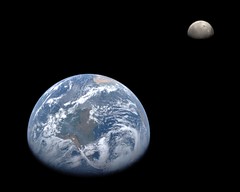
ugordan
Feb 5 2008, 02:59 PM
Here's a montage of Earth and Moon from MESSENGER. I used both the blue and violet filters for Earth because they're fairly narrowband and the violet filter better captures the Rayleigh scattering effect of the atmosphere than the longer wavelength blue. The Moon is a narrow-angle image taken a couple of days earlier and colorized using much lower resolution wide-angle data.
Earth is presented in a gamma-correct version so the contrast is different than in the official release. Earth's color balance is based on recent digital imagery from the Shuttle/ISS missions. I'm always striving to improve Earth's color in my images, this is currently my best guess and I'm fairly pleased with how it turned out.
Oh my....
"Beautiful" doesn't even begin to do that justice.
Can't help wondering what it will be like for the astronauts of the future, to see that view through their spaceship window as they come home after a mission to Mars, or Europa, or to another star...
Just magical.
djellison
Feb 5 2008, 03:24 PM
I wonder if, with the Dawn flyby - we might get a similar view of Mars. We have a recent similar shot of Mercury, and Venus - it'd be great to wrap up a nice inner-solar system family portrait
ugordan
Feb 5 2008, 03:41 PM
Now that you mention it, the Mercury image and this one do have almost completely the same phase angles.
Speaking of Mars, I wonder how much longer it's going to be before any Rosetta data hits the PSA (*cough*Mars flyby*cough*)...
rogelio
Feb 5 2008, 03:54 PM
Nice picture, ugordan.
Are those smoke plumes from Amazonian forest fires? (I'm referring to the wispy features to the south of the river, not the obvious clouds to the north).
If so, it's quite sobering that they could be seen from 10,000's of km away...
charborob
Feb 5 2008, 04:12 PM
Very nice image, except the Moon is not in its correct orientation. We can see features invisible from Earth, namely Mare Orientale and part of the farside
ugordan
Feb 5 2008, 04:19 PM
QUOTE (charborob @ Feb 5 2008, 05:12 PM)
Very nice image, except the Moon is not in its correct orientation. We can see features invisible from Earth, namely Mare Orientale and part of the farside
I said it's a
montage, not an exact scene visible from the spacecraft. The Earth-Moon system did not look like this at any single time during the flyby, the phase angle difference makes that pretty obvious. Think of it as "artistic license" - putting the moon "closer" to the source of illumination because it's at a higher phase angle. As to putting the Moon to the left of the planet (at that time it was waaay up and to the left of Earth), I dunno, this looked more aesthetic to me. I didn't want to put the Moon in an inset box either for that reason.
Rogelio, I can't tell if those are forest fires or not. The official image advisory doesn't mention them, but I've found a site concerned with forest fires which claims the 2005 year was particularly bad in terms of fires in the Amazon (something about reduced rainfall that season). It does look like smoke, but then again, it could be low haze due to air humidity in the region. It's widespread all the way to the Andes so I'm inclined to say that's indeed smoke. I can't find any GOES-East satellite archive going back to August 2005 to better see what that was.
tedstryk
Feb 5 2008, 05:15 PM
Amazing!
Ant103
Feb 5 2008, 05:42 PM
Good god

I've found the desktop wallpaper of the day
.
Thanks
.
centsworth_II
Feb 5 2008, 06:23 PM
QUOTE (charborob @ Feb 5 2008, 11:12 AM)
Very nice image, except the Moon is not in its correct orientation. We can see features invisible from Earth...
But the image is not seen from the Earth's perspective.
remcook
Feb 5 2008, 06:28 PM
amazing work as usual!
Juramike
Feb 8 2008, 12:07 PM
Thank y'all for this thread!
Using these resources I was able to snag an image taken today (February 8, 2008) of three tropical cyclones simultaneously churning in the South Indian Ocean.
Click to view attachment(Starting to look like Jupiter down there, isn't it?)
This site was used to access this image:
http://www.goes.noaa.gov/goesfull.html-Mike
QUOTE (ugordan @ Feb 5 2008, 02:59 PM)
Here's a montage of Earth and Moon from MESSENGER. .... I'm always striving to improve Earth's color in my images, this is currently my best guess and I'm fairly pleased with how it turned out.
Me too! Thanks for giving me permission to use it, Gordan!
"No Place Like Home..."
ugordan
Feb 9 2008, 05:16 PM
You're welcome, Stu!

Juramike
Jul 6 2008, 08:51 PM
Combination of Water Vapor (primarily), Infrared, and Visible images from the GOES-East geostationary satellite. These images were downloaded from the Dundee Receiving Station
website today (images for July 6, 20081500 UTC)
Click to view attachmentAqua and blue tones indicates higher levels of water vapor, while maroon tones indicate drier air.
In the central Atlantic, Tropical Storm Bertha can be seen leaving a trail of clouds to the east as it pumps water vapor into the atmosphere.
-Mike
ugordan
Jul 6 2008, 08:58 PM
Ooh... funky stuff!
DDAVIS
Aug 3 2008, 01:02 AM
Thanks to Robert Beal of the John Hopkins Applied Physics Lab, I now have on my site a copy of the first color image of the Earth as a disk. It was made September 20, 1967 by the Department Of Defense Gravity Experiment satellite (DODGE). He worked on the mission, painting the spherical color target at the end of the boom and photographically assembling the color image. Beal sent me a file based on a print he made, which he had color balanced to resemble the ATS Earth image on my site. Upon my request he reconstructed the color scheme of the poorly imaged target from memory. I was told the colors used, similar in philosophy to Surveyor, were radiation resistant paints which happened to be of low saturation. The idea of a spherical color target is interesting, and strikes me as ingenious. If both target and background are sunlit the target can supply useful information at a wide range of lighting angles. Has this method been used in other camera carrying spacecraft?
In a separate version I have repainted the color target, fixing the motion blur in the boom in the blue channel, and tried to 'fine tune' the Autochrome like image into a kind of 'reconstruction' of how it might have appeared if all imaging steps worked ideally.
http://www.donaldedavis.com/2003NEW/NEWSTUFF/DDEARTH.html Don
That's quite a coup you have there, well done. I had no idea images like that were being taken so early on. Thanks for sharing it with us here.
Pertinax
Aug 4 2008, 03:50 PM
QUOTE (ugordan @ Feb 5 2008, 12:19 PM)
Rogelio, I can't tell if those are forest fires or not. The official image advisory doesn't mention them, but I've found a site concerned with forest fires which claims the 2005 year was particularly bad in terms of fires in the Amazon (something about reduced rainfall that season). It does look like smoke, but then again, it could be low haze due to air humidity in the region. It's widespread all the way to the Andes so I'm inclined to say that's indeed smoke. I can't find any GOES-East satellite archive going back to August 2005 to better see what that was.
A bit late but hopefully still helpful....
http://www.ncdc.noaa.gov/gibbs/image/GOE-12/VS/2005-08-02-15
Juramike
Aug 21 2008, 02:51 AM
Animated loop of the Atlantic Basin of the Earth from August 10-20, 2008 in Amazing AquaVision (click to launch 1 Mb animated GIF):
Click to view attachmentTropical Storm Fay (AKA "The Joker") can be seen pulsing her way into the Florida peninsula.
-Mike
(I gotta figure how to host the big version somewhere...)
PhilCo126
Aug 21 2008, 06:19 PM
Nice picture, ugordan, Moon orientation a bit too close to Earth... otherwise no remarks
hendric
Aug 21 2008, 07:28 PM
Juramike,
The best places for weather discussion I've found is Weather Underground, www.weatherunderground.com. Check out their blogs.
Juramike
Aug 21 2008, 10:24 PM
Weather Underground is a great site. I'm a huge fan of the Tropical blog.
The water vapor images of the Earth make our own planet seem so...alien. The overall beltlike appearance in the Water Vapor images of moist zones and dry zones make Earth look much more like Venus (with Earth just having a few more nodes).
The things that really piqued my interest in the (tiny) loop above are the clear zones that seems to be forming around and beyond developing warm core tropical systems like Tropical Storm Fay and Invest 94. These dark, dryish surrounding zones seem to actually "push and clear" into the ITCZ. I've just spent a few hours prowling on the web trying to figure what makes these clear zones in the Water Vapor loop (without much luck). The smaller swirls at the edge of Saturn's South Polar Vortex (multispectral imaging in
PIA08333) look kinda similar, as if the isolated eddies are "pushing and clearing" into surrounding belts. Are they formed by the same mechanism or totally different? Who knows?
It's fascinating how overall similar the structures are. Even the swirling loops around Antarctica look like Earth has it's own South Polar Vortex - just with a more fluid and changing boundary.
-Mike
jamescanvin
Sep 15 2008, 07:33 AM
Images of storms are rather off topic for this thread, i've moved them to a new one:
Storms from Orbit
This is a "lo-fi" version of our main content. To view the full version with more information, formatting and images, please
click here.


