Geostationary satellites caught the 22July2009 Eclipse!
Here's a striking shot over the Pacific Ocean from the GOES-W satellite at 0300 UTC:
Click to view attachment
Hi-res zoom of same region:
Click to view attachment
And here is an image from MTSAT over Asia, comparison with the day before image shows where the shadow is:
Click to view attachment
NASA's Earth Observatory has color images taken at 8:30 AM and 9:30 AM Tiawan local time. (0300 Z = 11 AM Tiawan time?):
http://earthobservatory.nasa.gov/IOTD/view.php?id=39520
-Mike
Full Version: Whole Earth images
This may be 180° off-topic, but are any photographic (or pseudo-photographic) "whole sky" images available? Showing, say, the visible night sky from Earth on a cylindrical projection?
QUOTE (Juramike @ Jul 23 2009, 09:16 AM) 
Geostationary satellites caught the 22July2009 Eclipse!
I don't know much about this... but shouldn't the geostationary satellites catch a solar eclipse every time?
They do.
I am confused - a geostationary orbit is fixed over a point of the earth - wouldn't that mean that they would only see an eclipse in the hemisphere they can see?
Would this little guy (which appears to have a new chance at launching) have a better view of the only sunlit side and thus all eclipses? Or would a satellite at the Earth-Sun L1 just see the transit of the moon across the earth's sunlit face rather than it's shadow?
Would this little guy (which appears to have a new chance at launching) have a better view of the only sunlit side and thus all eclipses? Or would a satellite at the Earth-Sun L1 just see the transit of the moon across the earth's sunlit face rather than it's shadow?
QUOTE (lyford @ Jul 24 2009, 01:15 PM)
I am confused - a geostationary orbit is fixed over a point of the earth - wouldn't that mean that they would only see an eclipse in the hemisphere they can see?
The geostationary satellites (plural) do see every eclipse. Not every individual satellite sees every eclipse though.
QUOTE (Hungry4info @ Jul 24 2009, 10:59 AM)
I don't know much about this... but shouldn't the geostationary satellites catch a solar eclipse every time?
They do but the timing of the publicly available images has to match up to work. GEOS-W images are available every 3 h period, at 0000, 0300, 0600, etc. So for us in the "cheap seats" you need to have the shadow visible in the illuminated field of view at the right time.
The satellite over the southern Indian Ocean (I forget the name offhand) only has images available every 6 h time point. The timing didn't match, I couldn't find an image of the shadow over India/SW China.
So far I've only found 2 images of the shadow: The GOES W 0300 UTC observation and the METSAT 0300 UTC observation. (+ the NASA processed image of the 0130 observation which is not available to the public as a "raw image"?)
Both of these are thus two images of the shadow at the same time and place but from two different viewpoints high above the Earth.
QUOTE (jmknapp @ Jul 24 2009, 01:56 PM)
This may be 180° off-topic, but are any photographic (or pseudo-photographic) "whole sky" images available? Showing, say, the visible night sky from Earth on a cylindrical projection?
Yes, here's one version (go to FTP link)
http://sos.noaa.gov/datasets/solar_system/all-sky.html
QUOTE (Juramike @ Jul 23 2009, 04:16 PM)
Geostationary satellites caught the 22July2009 Eclipse!
With some delay, I made a couple of wallpaper compositions with such images, with some denoise in the former and a "difference" image in the latter.
QUOTE (scalbers @ Jul 25 2009, 10:56 AM)
Excellent... wish I had skies dark enough to see that!
QUOTE (jmknapp @ Jul 24 2009, 07:56 AM)
This may be 180° off-topic, but are any photographic (or pseudo-photographic) "whole sky" images available? Showing, say, the visible night sky from Earth on a cylindrical projection?
The good news is that the PC planetarium program Desktop Universe incorporated a color CCD mosaic covering the whole sky. The bad news is that the company producing it seems to have vanished, and secondary vendors may or may not have copies. (I meant to buy a copy, really I did). It's not too hard to make something usable from a star catalog, perhaps augmented with some fisheye Milky Way pictures. Yeah, I meant to do that background production once too...
Edit - I just saw the previous post with an ftp address for Axel Mellinger's wonderful all-sky mosaic. I can't get to it (something about too many redirects). If that's a persistent problem, he has versions on his own site.
Yes, here's the FTP link to the cylindrical version I was mentioning:
ftp://public.sos.noaa.gov/astronomy/milky...ll_sky/2048.jpg
ftp://public.sos.noaa.gov/astronomy/milky...ll_sky/2048.jpg
That cylindrical map isn't aligned with the celestial north pole at top v_v. But it is pretty 
QUOTE (Phil Stooke @ Jul 28 2009, 12:16 PM)
Chandrayaan saw the eclipse:
Cool, a very special viewpoint! I made a rough animation, correcting different zoom of images... slight orientation/aspec ratio differences still visible, however (do someone knows original images without caption?).
Check out the time-lapse footage of the eclipse from the Echostar 11 GEO satellite: http://www.youtube.com/watch?v=TV5y0wFA_GM
Something I've been working on for a while...combining multichannel IR images of Earth in a meaningful way.
Here is the new and improved pseudocolor Aquavision view of Earth:
Click to view attachment
IR4 [10.7 um], IR2 [3.9 um], and WV [6.7 um] are all combined using a complex channel mix into the RGB.
Here are what colors the correspond to:
aqua: water-laden air at mid-latitudes
red/brown: dry air
white: cold thick cloudtops (cumulonimbus)
purple/magenta: cold cirrus clouds (outflow)
hazel: warmer suface stratus clouds or fog
(IR2 measures lower level surface cloud temps, while IR4 measures upper level ice cloud temps)
Hi IR2 emission/Lo IR4 emission = DarkIR2/WhiteIR4 = warm surface terrain /cold ice clouds = cirrus
Lo IR2 emission/Hi IR4 emission = White IR2/DarkIR4 = cold surface terrain/ warm high altitudes = stratus or fog.
Note how Hurricane Bill causes downwind (in this case to the NE) flow effects like storms on Jupiter.
At some point I'm gonna apply this technique to another planet....
-Mike
QUOTE (djellison @ May 9 2007, 08:21 AM)
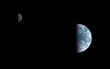
While doing that, I also found an Earth-Moon conjunction observation from the Earth 2 flyby that is very Cassini-esque
This one has been itching me for years. I've animated all but the ending couple of overexposed frames - in total 54 frames, in color.
First, a regular animated GIF (caution, it's over 8 megabytes) can be found here on my Flickr page. Second, an experiment with motion interpolation where I "upsampled" the framerate 5x. The resulting AVI (DivX codec) runs at a smooth 25fps and can be found here. The motion compensator obviously can't cope well with features emerging from the terminator, but overall it doesn't look half bad. If I find a better motion compensator, I might update this.
The sequence ended up more difficult than I expected, partly due to significant data dropouts, partly due to noise level. One set had the IR filter miss the scene completely, and another frame had a bad violet filter dropout so they were real salvage jobs. Significant underexposure, Galileo SSI 8-bit A/D converter combined with the fact this is presented gamma-corrected produced ugly background noise that took considerable effort to clean up.
Here are two higher quality takeouts, using the overexposed infrared/violet frames at observation start and end, one optimized for the Moon, the other for the Earth:

Oooh awesome awesome awesome, Gordan.
Did I mention AWESOME?
Can you explain what causes the "glow" around Earth's limb?
This is tremendous. I've looked at that data and I know how gungy it is -- it took a lot of work! Thank you!
I enjoy the specular reflection off of the oceans!
Does anybody have any brilliant ideas on how to find out what was happening in terms of weather on December 8, 1992? The animation appears to cover the Pacific Ocean, Australia, and Asia, finishing with eastern Africa on the terminator.
--Emily
QUOTE (elakdawalla @ Dec 21 2009, 12:16 AM)
Can you explain what causes the "glow" around Earth's limb?
First I have to ask if it's the same brightness as in the GIF, because it's supposed to be? If it's not it didn't turn out right and it's a funkiness to the AVI codec instead.
It's just the fact that in the end, the SSI is still just a real-world camera with its limitations. The optics are imperfect - diffraction/diffusion internal to the camera cannot be avoided. As I said, this was meant to more accurately convey actual contrast. The usual processing given to images enhances the contrast, suppressing darker areas more and as a result hiding low background noise and such soft diffuse glow around bright objects. Cassini's cameras exhibit this as well (and I'm not talking about that haze problem). My guess is it's the filter as long wavelength infrared filters ehxibit this diffuseness more, on both Cassini and Galileo.
P.S. This sequence was taken between 16 Dec 1992 15:40 UTC and 17 Dec 1992 04:50 UTC. At the beginning you can just see the Americas moving off toward the limb.
I just realized that makes it 17 years almost to the day since that observation. 17 years, wow...
QUOTE (elakdawalla @ Dec 20 2009, 11:16 PM)
Does anybody have any brilliant ideas on how to find out what was happening in terms of weather on December 8, 1992? The animation appears to cover the Pacific Ocean, Australia, and Asia, finishing with eastern Africa on the terminator.
Emily - we might be able to correlate with these views for the 16th. I can key on the storm over Australia in both images.
http://www.ncdc.noaa.gov/gibbs/html/GMS-4/IR/1992-12-16-21
http://www.ncdc.noaa.gov/gibbs/html/GMS-4/VS/1992-12-16-21
Other times and satellites can be selected here:
http://www.ncdc.noaa.gov/gibbs/availability/1992-12-16
It's fun though difficult to try and see cloud motions in the Galileo animations.
As a side note I'm considering trying to make simulated real-time global visible satellite images that should give much the appearance of the Galileo animations using Science On A Sphere. These would have the terminator and night-time lights added for some sort of realism.
I just wonder which is the first image of the "full" disk of Earth ? Should it be an image taken by Luna 1 or Pioneer 4 ?
It's hard to find full data of those spacecrafts to check that, but maybe you may know...
It's hard to find full data of those spacecrafts to check that, but maybe you may know...
Good question. Definitely not any of the early Lunas, and IIRC none of the Pioneers before P10 even had cameras. I'd actually bet that it was one of the Lunar Orbiters (LO3?)
EDIT: No, wait a minute: Might have been TIROS 1. Will check it out.
EDIT: No, wait a minute: Might have been TIROS 1. Will check it out.
Apparently, it's before Lunar Orbiter 1:
http://nssdc.gsfc.nasa.gov/imgcat/html/obj...1_h102_123.html
I quote: "This is the first good image of the Earth taken from the vicinity of the Moon, 380,000 km away."
For me, "good" means that there were bad pictures earlier.
http://nssdc.gsfc.nasa.gov/imgcat/html/obj...1_h102_123.html
I quote: "This is the first good image of the Earth taken from the vicinity of the Moon, 380,000 km away."
For me, "good" means that there were bad pictures earlier.
And this can not be TIROS 1, as its apogee is only 756km. I even think that the first geostationnary satellites may not be the first to take that picture, as very elliptical orbits (reached before GEO) can allow observing the entire earth.
which is the first image of the "full" disk of Earth ?
The first crude B&W television image of the Earth as a disk was made by a Soviet weather satellite on May 30, 1966. The first crude color image of Earth as a disk was made by the Department Of Defense Gravity Experiment satellite (DODGE) operating between July and November 1967
http://www.donaldedavis.com/2003NEW/NEWSTUFF/DDEARTH.html
Great, thanks for all those information !
But do you have any idea of the identity of that "Soviet weather satellite" ? Because I have controversal sources. According that page, Kosmoss 122 is the first soviet weather satellite and has been launched... the 25th June 1966 (after your image snap date).
But according to the ESA page here, the first soviet weather satellite is Kosmos 144, launched in Feb. 1967.
Other sources have more fuzzy descriptions of Kosmos 122, such as here, describing it as the first soviet weather satellite of the Meteor class (as a prototype).
QUOTE (scalbers @ Dec 21 2009, 01:32 AM)
Emily - we might be able to correlate with these views for the 16th. I can key on the storm over Australia in both images.
Wow, I didn't realize you could go back and look at the weather this far back. Thanks, Steve. Nice to see the weather matching up between the two sources.

A fun fact - Galileo was 6.15 million km from Earth at the start of the sequence and that increased to 6.58 million km at the end. At that distance, the Moon is just 6% closer in so the relative sizes of the two bodies are preserved fairly well. Also, during those 13.5 hours Galileo actually covered more than one lunar distance. Sure doesn't look so in telescopic imagery, does it?
EDIT: Using Steve's link above, these two observations were near-simultaneous (to the minute), they indeed match the clouds right down to the terminator line.

QUOTE (elakdawalla @ Dec 21 2009, 12:16 AM)
Does anybody have any brilliant ideas on how to find out what was happening in terms of weather on December 8, 1992? The animation appears to cover the Pacific Ocean, Australia, and Asia, finishing with eastern Africa on the terminator.
I don't have any "brilliant ideas". But here are a couple of comments and links that might prove useful:
The first link shows winds at 500, 700, and 850 mb, along with the surface analysis for 8 Dec 1992.
http://www.meteo.psu.edu/~gadomski/NARR/1992/us1208.php
Unfortunately, these maps only cover the continental US. But notice the trough on the west coast. That accounts for the clouds visible in western North America. And interestingly, resulted in storms that produced 5 inches of rain in Los Angeles, and over two feet of snow in the Sierras.
This PDF link to the Weekly Weather and Crop Bulletin for the week of 6-12 December 1992 shows the resulting weather (primarily focused on precipitation) in the US and elsewhere around the world. But it is weekly summaries, rather than detailed weather for 8 Dec 1992.
http://usda.mannlib.cornell.edu/usda/waob/...-12-15-1992.pdf
Probably not of much use. But Emily's question piqued my interest. And yes, Gordan, the animation is fantastic! Thanks again for your great work here.
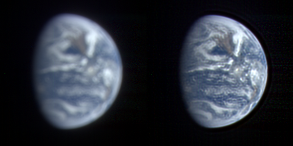
Here's another Earth animation, this one a Deep Impact a.k.a. EPOXI HRI sequence taken March 18/19 2008 from cca. 27 million km. The images are blurry, I deconvolved them but that introduced ringing artifacts. A special thanks to Sean Walker for pointing me to MaxIm DL 5 I used for deconvolution. I used the supplied PSF for the imager on the data volumes. Here's a comparison of a source image and deconvolved one (click):
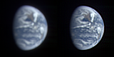
The sequence consists of 97 frames taken every 15 minutes and spanning one whole day. For some reason a couple of frames wouldn't converge in deconvolution, these are noticeable as blurred frames. Also, the calibrated data apparently had a line of noisy/hot pixels running near the center of detector, deconvolution made it worse and Earth's terminator is artifacted in some frames, notably at the beginning.
The animated gif (5 megabytes) can be found here.
The first and last frames are exactly 1 day apart, here's a flicker gif showing cloud evolution in the Pacific. Corresponding satellite imagery (GOES 11): March 18 and March 19. Even though there are ringing artifacts due to deconvolution, more of the smaller cloud details than I anticipated are actually real, as illustrated here.
While the Galileo animation was taken near winter solstice, this was taken very close to spring equinox and illustrates a difference in illumination - both sequences have the sun to the right, but Earth spins differently.
EDIT: fixed the few exceedingly blurry frames in the animation.
Gordan, pretty impressive results for the deconvolution as I could see some of the cloud features in your comparison. I suppose having the PSF helped, as well as maybe high bit resolution in the dataset. Nice to have the animation span an entire day as I can see all the continents coming into view.
Make me wonder just what the genius of people like Damian Peach et.al. could do if we all lived on Mars, and Earth was just an astronomical target through 12" telescopes. I think it would be quite a lot like that image sequence. Awesome work!
Steve, yes, this observation is at a significantly larger pixel scale than the Moon transit sequence from May 2008. Every bit helps.
Doug, without a doubt, to anyone living on Mars Earth would be competing with Jupiter as the most photogenic object out there!
Doug, without a doubt, to anyone living on Mars Earth would be competing with Jupiter as the most photogenic object out there!
QUOTE (Lightning @ Dec 20 2009, 05:20 PM)
Apparently, it's before Lunar Orbiter 1:
http://nssdc.gsfc.nasa.gov/imgcat/html/obj...1_h102_123.html
I quote: "This is the first good image of the Earth taken from the vicinity of the Moon, 380,000 km away."
For me, "good" means that there were bad pictures earlier.
http://nssdc.gsfc.nasa.gov/imgcat/html/obj...1_h102_123.html
I quote: "This is the first good image of the Earth taken from the vicinity of the Moon, 380,000 km away."
For me, "good" means that there were bad pictures earlier.
This image has been cleaned up by LOIRP, and can be viewed here.
I don't think that is from LOIRP, but it is a nice image.
Ted's right. LOIRP has done that image, but the linked version is not theirs.
Phil
Phil
One of the first attempts to image Earth from space, was possibly from Able-1 (Pioneer 2?) probe, but failed, because major part of Earth seen from spacecraft was in darkness.
QUOTE (tedstryk @ Jan 20 2010, 03:25 AM)
I don't think that is from LOIRP, but it is a nice image.
Sorry, I should clarify. You can find the "LOIRP TIFF" linked at the bottom of the page. It apparently weighs 1.2 GB, so I didn't direct-link it.
edit: Aha. You can preview it here.
So huge... did someone made a lighter med-res version?
I don't know if it's true for this one, but when I have downloaded LOIRP TIFFs in the past, I found they had two layers, one of which was empty, but both of which were saved without compression, needlessly doubling the file size. All they have to do is toss the extra layer and use LZW compression and it'd save a lot of people a lot of time (and them a lot of bandwidth).
Image of Earth taken today at 1800Z (several hours ago). A zoom shows a weird pattern in the IR4 and Water Vapor channels that is roughly funkiest right over Columbia, South Carolina.
Click to view attachment
It is not evident in the Visible image and only faintly discernible from white background in the IR2 image. (So...colder high altitude contrails? Why not over the busier airports of Atlanta or Charlotte?)
Any guesses??
Click to view attachment
It is not evident in the Visible image and only faintly discernible from white background in the IR2 image. (So...colder high altitude contrails? Why not over the busier airports of Atlanta or Charlotte?)
Any guesses??
Gotta be contrails. Answer is that those are high-alt corridors. Near the airports planes are ascending or descending, not cruising @ 30K+ ft., therefore much slower speeds & much shorter ground tracks.
QUOTE (Juramike @ Jan 28 2010, 01:58 AM)
Any guesses??
Not only do contrails not show up over the major airport hubs (where aircraft are indeed at lower levels) the contrails will only show up where there is sufficient moisture in the upper atmosphere for the contrails to persist long enough to be imaged from space. There was obviously more moisture available over SC at the time this photo was taken, than in areas farther south, where the contrails do not persist.
David
Thanks!
I poked around other time points on the same day, and same time point on different days and didn't see the same phenomenon. Must've just hit the atmospheric conditions just right over the Carolinas. Color us lucky...'till the snowstorm hits this weekend.
I poked around other time points on the same day, and same time point on different days and didn't see the same phenomenon. Must've just hit the atmospheric conditions just right over the Carolinas. Color us lucky...'till the snowstorm hits this weekend.
The Dundee Satellite Receiving Station home page (DSRS) (here) has just activated a very neat feature. They have a clickable calendar at the top of the screen, you can now easily click back and forth through the archive.
With a fast enough connection, this can almost be a stepwise animation.
With a fast enough connection, this can almost be a stepwise animation.
24 hour animated sequence of Earth images in Aquavision from May 27th 0600 UTC to May 28th 0300 UTC:
Available here: http://www.flickr.com/photos/31678681@N07/4646189185/
Available here: http://www.flickr.com/photos/31678681@N07/4646189185/
Great new mosaic from LROC:
http://lroc.sese.asu.edu/news/index.php?/a...m-the-Moon.html
http://lroc.sese.asu.edu/news/index.php?/a...m-the-Moon.html
Has anyone mentioned this link showing real-time Meteosat images?
http://oiswww.eumetsat.org/IPPS/html/MSG/IMAGERY/
http://oiswww.eumetsat.org/IPPS/html/MSG/IMAGERY/
This is neat - July 11 solar eclipse seen on the DishEARTH channel.
Digging around, I found some really neat high-phase angle shots of Earth taken by the SEVERI Meteosat near the December 21 solstice. This is taken at local midnight, so we are seeing the midnight sun over Antarctica.
At this high phase angle, the Near IR data isn't too bright and can be gently blended into a channel mix with the Vis R-G and Vis G-B to make a pretty RGB composite.
There's a neat specular reflection off Antarctica ice or smooth embayed water.
Click to view attachment
Check out the REALLY high res image on my flickr site (processing details there, too.): http://www.flickr.com/photos/31678681@N07/4937955948/
This is a "lo-fi" version of our main content. To view the full version with more information, formatting and images, please click here.