Here's a colorization of this LRO Earth image. Below is a preview at 10% resolution, 1/2 res version is available here (2.3 MB) and full res version here (8 MB).
Click to view attachment
Full Version: Whole Earth images
The full version is extremely impressive! I can see clearly where I'm at the moment with some details, lake Chungara south East of Lake Titicaca.
The earth's image is awesome. Wow! The earth's is beautiful to look at a distant.
Interesting post on gizmodo about data coming from a Russian weather satellite:
http://gizmodo.com/#!5787176/this-is-t...een-them-before
http://gizmodo.com/#!5787176/this-is-t...een-them-before
Whole Earth images - but from long, long ago..
https://sites.google.com/a/upr.edu/planetar.../library/vpe-pr
VERY cool
https://sites.google.com/a/upr.edu/planetar.../library/vpe-pr
VERY cool
Agreed, those are awesome!
I am so going to make a gif animation of those three maps, for use in my Outreach talks! 
Hey Stu, check out this animation (from Early Precambrian to present):
http://en.wikipedia.org/wiki/File:Tectonic...tionGlobal2.gif
http://en.wikipedia.org/wiki/File:Tectonic...tionGlobal2.gif
Very cool as well, Mike! However, I think that the last image in the animation is probably of the end of the last ice age or so; the Red Sea is much larger, and it looks like the central Asian seas are still merged together.
Good catch! It is indeed the Neogene-Miocene period as the last step in the animated gif. The work that Stu originally referred to was done in collaboration by Dr. Ron Blakely of Northern Arizona University. (The animations in the wikipedia entry were done by Dr. Ron Blakely.)
Here is his website that has individual maps of each of the paleo-reconstructions (including Pleistocene and Present) :
http://jan.ucc.nau.edu/~rcb7/mollglobe.html
And a website to other detailed data products:
http://cpgeosystems.com/index.html
I recently got a copy of his (beautifully illustrated) book: "Ancient Landscapes of the Colorado Plateau", mentioned on his site. I highly recommend it.
Animation created from simultaneous views of Earth from five geosynchronous weather satellites taken every six hours starting on March 21, 2011:
Click to view attachment
[animated GIF: click to animate]
Click to view attachment
[animated GIF: click to animate]
A few more images of Elektro-L, the Russian geostationary weather satellite can be found here (among others, like Resurs-DK and Meteor-M):
http://eng.ntsomz.ru/news/news_center
http://eng.ntsomz.ru/news/news_center
Chandrayaan-1 view of the Earth during the solar eclipse of July 22nd, 2009 revisited. Very noisy, 4 visible channels of M3 centered at 620, 580, 540 and 500 nm were processed into this approximately natural color view. The 460 nm channel was useless. The way the M3 instrument scanned, the resolution in the vertical axis is much higher than horizontal.
Click to view attachment
Click to view attachment
Wow, really cool. There is a ghost image of Earth about three diameters to the right of the actual image -- do you know what causes that?
There's a whole bunch of artifacts visible there. Don't know about that specific ghost, I would assume this is optics related. I noticed imaging spectrometers of this type (pushbroom), VIMS visual channel included have subtantial stray light leakage both in the vertical and especially horizontal direction. You can notice the hot pixel columns get brighter left and right of a bright object. I deliberately left all this crud in to make it clear the other non-removable artifacts, such as vertical discolorations on Earth's disc are in fact artifacts and not real.
I should point out this was done using the raw data, of all the M3 images there are archived this one was not provided in a calibrated form. Perhaps because it was a one-off observation. I had to do manual bias subtraction and rudimentary "I/F" conversion. The whole M3 swath actually included another Earth image higher up, vertically flipped. I presume it was taken when the s/c was slewing back and judging by Earth's rotation it was taken a couple of minutes later. I can post a flickr gif of the two, but it's nothing spectacular.
I should point out this was done using the raw data, of all the M3 images there are archived this one was not provided in a calibrated form. Perhaps because it was a one-off observation. I had to do manual bias subtraction and rudimentary "I/F" conversion. The whole M3 swath actually included another Earth image higher up, vertically flipped. I presume it was taken when the s/c was slewing back and judging by Earth's rotation it was taken a couple of minutes later. I can post a flickr gif of the two, but it's nothing spectacular.
I don't know the instrument--but that sort of thing is frequently due to a double reflection within a window that separates the fore-optics from the outside universe. Depending on the material (silica, sapphire, ...) you get a significant fall-off for a double reflection, and then the same fall-off to quad, etc.
QUOTE (elakdawalla @ Aug 13 2011, 09:43 AM) 
...There is a ghost image of Earth about three diameters to the right of the actual image...
There is also a ghost image the same distance to the left.QUOTE (Juramike @ Apr 22 2011, 12:25 AM)
Good catch! It is indeed the Neogene-Miocene period as the last step in the animated gif. The work that Stu originally referred to was done in collaboration by Dr. Ron Blakely of Northern Arizona University. (The animations in the wikipedia entry were done by Dr. Ron Blakely.)
Here is his website that has individual maps of each of the paleo-reconstructions (including Pleistocene and Present) :
http://jan.ucc.nau.edu/~rcb7/mollglobe.html
And a website to other detailed data products:
http://cpgeosystems.com/index.html
I recently got a copy of his (beautifully illustrated) book: "Ancient Landscapes of the Colorado Plateau", mentioned on his site. I highly recommend it.
Here is his website that has individual maps of each of the paleo-reconstructions (including Pleistocene and Present) :
http://jan.ucc.nau.edu/~rcb7/mollglobe.html
And a website to other detailed data products:
http://cpgeosystems.com/index.html
I recently got a copy of his (beautifully illustrated) book: "Ancient Landscapes of the Colorado Plateau", mentioned on his site. I highly recommend it.
Yes, this is a good dataset. We've used a smoother version of this animation in Science On A Sphere.
http://sos.noaa.gov/datasets/Land/paleo.html
A frame exists for the future projection of the continents. I've considering making an augmented version of the animation that incorporates this into the future.
Steve
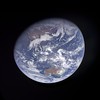
QUOTE (ugordan @ Sep 16 2010, 11:39 PM)
Here's a colorization of this LRO Earth image. Below is a preview at 10% resolution, 1/2 res version is available here (2.3 MB) and full res version here (8 MB).
Click to view attachment
Click to view attachment
Very lovely, except for the Photoshop masking artifacts around the edge (mainly in the 12 o'clock to 2 o'clock positions).
The NPP mission is making a Global Image (not just hemispherical) of the Earth every day. Here is the first image release:
http://earthobservatory.nasa.gov/IOTD/view.php?id=76674
"It's 1:30 PM somewhere..."
http://earthobservatory.nasa.gov/IOTD/view.php?id=76674
"It's 1:30 PM somewhere..."
Rosetta Earth flyby 2 revisited, magnified 1.5x from original scale and rotated so north is up:
This one was hard to work with. The red and especially the green channel suffers from a ghost image which makes the composite look ugly. I tried subtracting them out as best as I could but it still left residual images of the bright clouds in the green channel. As a result, fair portions of the sea and cloud areas use synthetic green while most of the land masses use RGB colorm as synthetic green doesn't produce satisfactory color.
This one was hard to work with. The red and especially the green channel suffers from a ghost image which makes the composite look ugly. I tried subtracting them out as best as I could but it still left residual images of the bright clouds in the green channel. As a result, fair portions of the sea and cloud areas use synthetic green while most of the land masses use RGB colorm as synthetic green doesn't produce satisfactory color.
Great work, Gordan!
I abandoned the very same data set for the reasons you mention.... GREAT work.
QUOTE (scalbers @ Aug 14 2011, 01:00 AM)
Yes, this is a good dataset. We've used a smoother version of this animation in Science On A Sphere.
http://sos.noaa.gov/datasets/Land/paleo.html
A frame exists for the future projection of the continents. I've considering making an augmented version of the animation that incorporates this into the future.
Steve
http://sos.noaa.gov/datasets/Land/paleo.html
A frame exists for the future projection of the continents. I've considering making an augmented version of the animation that incorporates this into the future.
Steve
Updating this post - the animation for past continental drift has moved to here: http://sos.noaa.gov/Datasets/dataset.php?id=336
And I've been putting together a future projection animation, from some of Ron Blakey's future frames:
http://sos.noaa.gov/Datasets/dataset.php?id=424
Here is a sample image from the Himawari AHI color imager. Full color and very high resolution. The available one is 11000x11000 pixels (about 1km resolution). This is a sample of a newly launched weather satellite. Will be interesting to see how high of a resolution is publicly available in real-time.
Click to view attachment
http://www.jma-net.go.jp/sat/data/web89/pa.../trc/trc_LL.jpg
http://www.jma.go.jp/jma/jma-eng/satellite...rst_images.html
Click to view attachment
http://www.jma-net.go.jp/sat/data/web89/pa.../trc/trc_LL.jpg
http://www.jma.go.jp/jma/jma-eng/satellite...rst_images.html
QUOTE (Juramike @ Dec 23 2011, 01:50 AM)
The NPP mission is making a Global Image (not just hemispherical) of the Earth every day. Here is the first image release:
http://earthobservatory.nasa.gov/IOTD/view.php?id=76674
"It's 1:30 PM somewhere..."
http://earthobservatory.nasa.gov/IOTD/view.php?id=76674
"It's 1:30 PM somewhere..."
VIIRS composites are also available here: http://www.nnvl.noaa.gov/site-custom/true.php
GOES-16 has been up a while. I'm unsure if real-time data are available yet. It's one thing to get images online, though the ABI has 16 channels and judicious use of the "data" can allow construction of more visually realistic imagery. The full disk data is 0.5 to 2km resolution (depending on wavelength) every 15 minutes.
The main idea is that red is at 500m resolution, blue is at 1km, and near-IR data at 2km can be used to help synthesize the green vegetation. Most of the "True-Color" online images are actually somewhat enhanced, though access to the data can help to make more of a natural color image. The thing I would look for is the ABI L1b radiance products. Maybe CLASS will be made public in the near future?
The main idea is that red is at 500m resolution, blue is at 1km, and near-IR data at 2km can be used to help synthesize the green vegetation. Most of the "True-Color" online images are actually somewhat enhanced, though access to the data can help to make more of a natural color image. The thing I would look for is the ABI L1b radiance products. Maybe CLASS will be made public in the near future?
Here's a link: https://pds-imaging.jpl.nasa.gov/volumes/loirp.html
Here are latest full disk images from GOES-West:
https://www.star.nesdis.noaa.gov/goes/fulld...R&length=12
Note that the Level 1b data are available for both GOES and Himawari on AWS.
https://www.star.nesdis.noaa.gov/goes/fulld...R&length=12
Note that the Level 1b data are available for both GOES and Himawari on AWS.
This is a "lo-fi" version of our main content. To view the full version with more information, formatting and images, please click here.