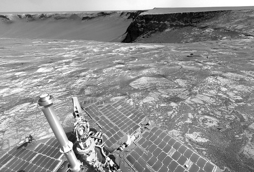
The pano above appears to show a nice example of the "Opposition Effect" around the Pancam assembly's shadow.
Airbag
Full Version: Bottomless Bay
A special treat on Sol 1030: A bottom row of Navcam images, taken at the same time as the top.
QUOTE (mhoward @ Dec 17 2006, 05:37 PM) 
A special treat on Sol 1030: A bottom row of Navcam images, taken at the same time as the top.
wonderful view !

The rest of what we needed for the color view of the B1 side of Bottomless Bay came down today. It is from the sols 1016-1019 position. This would be more artistically pleasing if I darkened it somewhat, but that wipes out some of the bedding details.
Click to view attachment
Click to view attachment
QUOTE (CosmicRocker @ Dec 15 2006, 02:55 AM)
That's the same darn blueberry image we argued about earlier. Remember the discussion of cone-shaped berries versus spherical? SS has also used the bathtub ring analogy (I think it is a great analogy) several times previously to describe the concept that the concretions diminished in size and possibly disappeared altogether as Opportunity climbed in elevation, and probably stratigraphically, above an ancient water table.
I think it was a decent article, but it is mostly recycled information from other sources.
I think it was a decent article, but it is mostly recycled information from other sources.
Considering the blueberry bathtub ring after a week or so, I was wondering how well the hematite rich bathtub ring could be roughly mapped with the Mini TES before entering the crater. (Remember the Mini TES images from Eagle crater).
On that regard, we haven't heard much about the Mini TES lately from NASA -- or on this forum for that matter. Do any of our sources have a way to know what's being done with instruments other than the cameras?
Steve
NE (Cape B1) side of Bottomless Bay - Sol 1019 - L257

Sharpened and shadow enhanced version.

James
Sharpened and shadow enhanced version.
James
Right, Steve. For apparent reasons, the simple imagery has always been in the public limelight on these missions. I wish they would feed us more frequently from the other bands. That crude miniTES overlay from Eagle pretty much told the initial story there, and surely guided future operations. I wouldn't mind seeing something similar at Victoria.
As freakin' gorgeous as usual, James. I was coming back to replace my image with a newer version where I corrected the data dropouts, but there is no reason to do that, now. I always wanted to teach myself to fill in the gaps. It was amazingly easy, but the result is still inferior, now that you have returned to the party. I am still amazed by your earlier posting of the L2 version colorized with the thumbnails, as I am with jvandriel's colorization. I am slowly catching on to some of the techniques, but I still find color balancing a challenge.
As freakin' gorgeous as usual, James. I was coming back to replace my image with a newer version where I corrected the data dropouts, but there is no reason to do that, now. I always wanted to teach myself to fill in the gaps. It was amazingly easy, but the result is still inferior, now that you have returned to the party.
I am still amazed by your earlier posting of the L2 version colorized with the thumbnails, as I am with jvandriel's colorization. I am slowly catching on to some of the techniques, but I still find color balancing a challenge.
WRT sol 1032 activities, it was a driving sol.
The rover moved towards the rim, as can be seen on these two navcam images.
Before (sol 1030): http://nasa.exploratorium.edu/mars/opportu...S3P0715L0M1.JPG
After (sol 1032): http://nasa.exploratorium.edu/mars/opportu...TUP1997L0M1.JPG
There is a single navcam pic at the exploratorium (as of 16:50 UTC) so it's too early to make any driving distance estimation.
Edited: 8m according to the rover's mobility data.
And my own version of the layers of Bottomless Bay 
Enjoy
Enjoy
Dont really understand fully the idea of bueberry bathtub ring and the proof that water interaction in the formation of the haematite within the sulphate rich rock was mainly subsurface rather than surface water.I kinda like the idea that Victoria being at a higher elevation than eagle and endurance craters indicates that the surface water was shallower at the higher areas which would account for the smaller sized berries.The higher concentration and bigger sized berries around Victoria would only result from the excavation of such berries by the impact that created Victoria rather than an indication that subsurface was the main culprit .Maybe I still dont get the gest of it!
I leave my marathon of creation of all spirit's pano for my HiRouteMap to make small pan of sol 1032
Click to view attachment
Click to view attachment
Wow...that is one of the most spectacular pans yet. Great work!
QUOTE (Indian3000 @ Dec 19 2006, 10:44 PM)
I leave my marathon of creation of all spirit's pano for my HiRouteMap to make small pan of sol 1032
congratulations ! very well done ... perfect stitching and impressive atmospheric feel with the extended sky
QUOTE (CosmicRocker @ Dec 15 2006, 01:55 AM)
That's the same darn blueberry image we argued about earlier. Remember the discussion of cone-shaped berries versus spherical? SS has also used the bathtub ring analogy (I think it is a great analogy) several times previously to describe the concept that the concretions diminished in size and possibly disappeared altogether as Opportunity climbed in elevation, and probably stratigraphically, above an ancient water table.
These remind me of a feature in Endurance Crater. Could this be a "bathtub ring"
Click to view attachment
QUOTE (Indian3000 @ Dec 19 2006, 03:44 PM)
I leave my marathon of creation of all spirit's pano for my HiRouteMap to make small pan of sol 1032
Mister Indian3000, that was beautiful. I think you have managed to capture technical perfection and lovely artistic impression in the same grayscale image. I love it. QUOTE (alan @ Dec 19 2006, 07:22 PM)
These remind me of a feature in Endurance Crater. Could this be a "bathtub ring"
It could well be one appearance of it, but don't think of the BTR as a chiseled line in the rock. If I have the model correctly imagined, it is more like the average highest reach of the the ancient water table. If the groundwater did not dwell for long above a certain level, there will probably not be very many concretions formed there. Probably at the same time the concretions are forming in the ground water saturated environment, other minerals may be dissolving and precipitating elsewhere, creating other changes in the textures of the rock. If the water remains near a level long enough, it can leave an imprint of its presence. But other processes can create an abrupt change such as the one you pointed out. That seems to be a contact worthy of further study.The geochemistry of iron during the formative years of the planets has long been been one of my favorite subjects. That element seems to have been quite abundant on/in the inner planets at the same time certain planets' atmospheres evolved from chemically reducing environments to more oxidizing ones, thus changing the chemical behavior of iron. Seeing such apparently ancient rocks with clues to that story, delivered to us by a space-faring robot created by our species, leaves me speechless...
QUOTE (alan @ Dec 21 2006, 12:52 AM)
I wondered that too, but it looks like the image is off to the west, about -79 degrees az. I reckon it's just capturing the after-sunset sky glow.
So, in color, it gave us that :
Click to view attachment
Click to view attachment
FWIW, new pics on the exploratorium after driving on sol 1034.
It looks like a small move, few meters I would guess. Perhaps the rover is positioning itself for a Christmas IDD campaing and/or get some long-baseline info from Bottomless Bay.
http://qt.exploratorium.edu/mars/opportuni...cam/2006-12-21/
It looks like a small move, few meters I would guess. Perhaps the rover is positioning itself for a Christmas IDD campaing and/or get some long-baseline info from Bottomless Bay.
http://qt.exploratorium.edu/mars/opportuni...cam/2006-12-21/
Six image mosaic from sol 1034
Click to view attachment
Click to view attachment
Nice one, alan. I loved the view of the tracks in that direction. The largest block in the ejecta layer on the left right side looks eerily familiar to me.
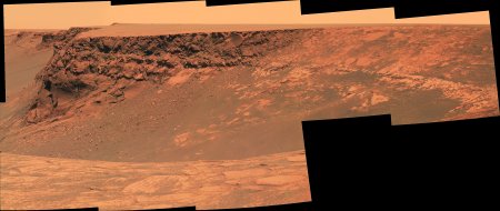
Here is the panorama in the drive direction. I think this provides the first good view of one of the north side dark streaks. What do you people think? I can't imagine what else it could be.
I wasn't expecting them to have quite as much contrast. I wonder if we'll be able to finally settle the discussions regarding whether they are light dust removal or dark dust deposition features when we get closer views.
Click to view attachment
QUOTE (alan @ Dec 22 2006, 09:45 PM)
Six image mosaic from sol 1034
Click to view attachment
Click to view attachment
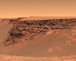
This really shows that there is a difference in the amount of dust on the North side faces as opposed to the South side faces. If we only have one shot to pick a place for Opportunity to examine, that's a big clue.
Gotta love those tracks.

QUOTE (CosmicRocker @ Dec 23 2006, 12:36 AM)
...
Here is the panorama in the drive direction. I think this provides the first good view of one of the north side dark streaks. What do you people think? I can't imagine what else it could be.
I wasn't expecting them to have quite as much contrast. I wonder if we'll be able to finally settle the discussions regarding whether they are light dust removal or dark dust deposition features when we get closer views.
It's interesting that while, according to the drive maps, we crossed over a faint dark streak at the head of Bottomless Bay between Sol 1027 and 1028, there has been no mention of pausing to look at the streak then.
If this seems an important question, it suggests that Opportunity will continue her circuit of Victoria at least until she reaches the really dark north streaks (around bay C5 and D2 in the unofficial nomenclature).
Steve
QUOTE (mhoward @ Dec 23 2006, 05:55 PM)
Gotta love those tracks.
Yeah very nice composition!
And also (gotta lov...) your perfectly stitched mosaics!
QUOTE (mhoward @ Dec 23 2006, 05:55 PM)
Gotta love those tracks.
I was doing the same but completely manual (I din't like AS output) and with sharpening:
Click to view attachment
Beautiful traks and stratified rocks, illumination is great and Capes sequence on the left is terrific... but, I'm still asking why we didn't visited Beacon balcony??

The panoramic view from Sol 1030
taken with the L0 Navcam.
After adding the bottom 3 images the matching of the horizon
is not perfect.
jvandriel
taken with the L0 Navcam.
After adding the bottom 3 images the matching of the horizon
is not perfect.
jvandriel
Here is the same view, but now without
the bottom row images.
jvandriel
the bottom row images.
jvandriel
Here is the panoramic view from Sol 1032.
Taken with the L0 Navcam.
jvandriel
Taken with the L0 Navcam.
jvandriel
Would be a lovely sunset here... (I bet the Sun direction isn't correct but hey, just going for "pretty"! )
Click to view attachment
) Click to view attachment
A Christmas view on Mars.
Taken on Sol 1034 with the L7 Pancam.
jvandriel
Taken on Sol 1034 with the L7 Pancam.
jvandriel
Beautiful mood, Stu!
Here below jv-based polar projection:
Here below jv-based polar projection:
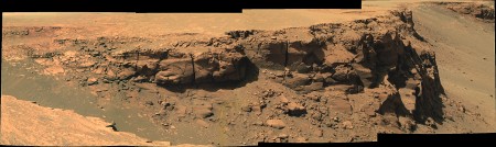
Gotta love all those beautifully layered rocks, too. Oh, to have one of those in front of me with a pick handy to split the layers apart... 
BTW, great image, Stu...it's now my desktop!
BTW, great image, Stu...it's now my desktop!
Here is the Navcam view from Sol 1034.
jvandriel
jvandriel
The view in the drive direction on Sol 1034.
Taken with the L2 Pancam.
jvandriel
Taken with the L2 Pancam.
jvandriel
A mosaic of 2 images made by the Mi Cam
on Sol 1035 after brushing.
jvandriel
on Sol 1035 after brushing.
jvandriel
Festive red/green images of Mars. Looking across Bottomless Bay, sols 1034 and 1036 long baseline stereo, L7 pancam:
Click to view attachment
Click to view attachment
As others have said, I love that view of the tracks coming over the ridge leading to the beacon.
I don't have my red/green glasses with me, so I hope the channels aren't switched!
Click to view attachment
Click to view attachment
As others have said, I love that view of the tracks coming over the ridge leading to the beacon.
I don't have my red/green glasses with me, so I hope the channels aren't switched!
The view until now.
Taken with the L7 pancam on Sol 1034.
jvandriel
Taken with the L7 pancam on Sol 1034.
jvandriel
QUOTE (nprev @ Dec 24 2006, 09:10 AM)
Gotta love all those beautifully layered rocks, too. Oh, to have one of those in front of me with a pick handy to split the layers apart...
I've commented elsewhere re Victoria's morphology, and pictures such as these simply reinforce my view that Victoria isn't an impact crater.
It was, once, of course. But since then it's suffered an almighty erosional process, so that the high-velocity artefacts imposed on the pre-existing stratigraphy have been for all intents and purposes removed. Thus, no boulder field at the rim, no overturned strata, and probably not even any shock cones. Instead, we have a pit, transformed by erosive processes from a crater - with the inevitable jumbling of histories which that would imply - into a real cross-section of Meridiani Planum. Really, it's far *more* scientifically interesting as a pit than as a crater.
I'd propose that such ex-craters should be named 'Diablos', after the original (well, Spanish) name for the Barringer Crater, before it's external origin was discovered.
Bob Shaw
75x45 degree perspective view... Happy Holidays...


Very good Michael
Here is a more natural colorisation of the panorama :
I've also made a desktop picture (2Mo png)
Here is a more natural colorisation of the panorama :
I've also made a desktop picture
(2Mo png)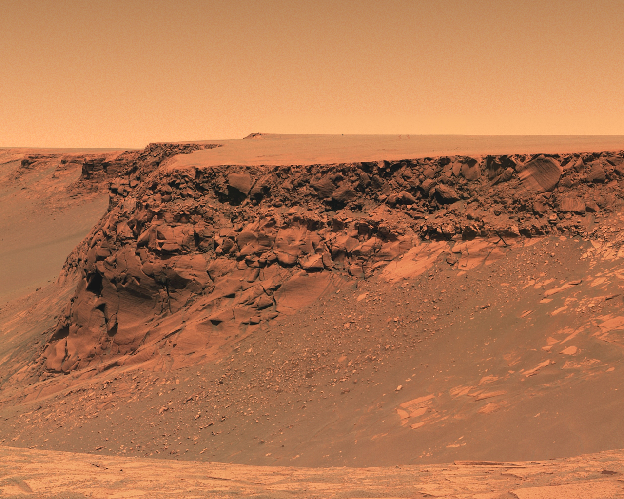
Beautiful!
Also the sight along the rim is specially great at this position.
Also the sight along the rim is specially great at this position.
Just trying something a little different...
Click to view attachment
Love this location, but can't wait to move a little farther around the edge to see some new details...
Click to view attachment
Love this location, but can't wait to move a little farther around the edge to see some new details...
> ... can't wait to move a little farther around the edge to see some new details...
You won't wait too much. Today is driving sol (1039) and we should have new pics in a few hours.
You won't wait too much. Today is driving sol (1039) and we should have new pics in a few hours.
Yes, something in the order of 55+ meters. There will be some nice new vistas of the Bay of Toil.
Ant,
I really appreciate when you add the desktop wallpaper versions.
That is really helpful for us image-challenged types.
David
I really appreciate when you add the desktop wallpaper versions.
That is really helpful for us image-challenged types.
David
Stu: Am I interpreting that correctly? Is that Jack Frost nipping at the plains of Meridiani?
So, next up is the Bay of Toil. Sounds difficult. The unfolding vista is pretty awesome. If they actually achieved 55 meters, it would have unfolded more awesomely, but it appears that the result of the 1039 drive was more like 23-25 meters. It looks like the next drive isn't in the tracking database yet.
So, next up is the Bay of Toil. Sounds difficult.
The unfolding vista is pretty awesome. If they actually achieved 55 meters, it would have unfolded more awesomely, but it appears that the result of the 1039 drive was more like 23-25 meters. It looks like the next drive isn't in the tracking database yet.
QUOTE (CosmicRocker @ Dec 27 2006, 05:56 AM)
Stu: Am I interpreting that correctly? Is that Jack Frost nipping at the plains of Meridiani?
Sadly not, it's just some weird "huh?" result of my messing about with the colours...
As usual I'm not trying to be 100% colour accurate, but rather going for a "look" and a "feel". I leave the colour perfection to others here with about a gazillion times more expertise than I! The new view's opening up nicely tho...
Click to view attachment
Stu:
Interesting colours, rather Bonestellian in tone...
...now, where *did* I park that big glider?
Bob Shaw
Interesting colours, rather Bonestellian in tone...
...now, where *did* I park that big glider?
Bob Shaw
This is a "lo-fi" version of our main content. To view the full version with more information, formatting and images, please click here.