Full Version: Bottomless Bay
Hang-gliding on Mars will be only a little more risky than base-jumping with a un-anchored bungee-cord!
Thanks for your comments 
Here is a version with the rover to have a scale of the structure :
Click to view attachment
(sorry for some inclusion trouble, it was a little hard to cut out the rover from JPL press release image)
Here is a version with the rover to have a scale of the structure :
Click to view attachment
(sorry for some inclusion trouble, it was a little hard to cut out the rover from JPL press release image)
QUOTE (Bob Shaw @ Dec 24 2006, 10:36 PM) 
Bob Shaw
Great to have you back Bob. New computer for Christmas, was it? Time has flown, but not nearly enough bananas.
QUOTE (Ant103 @ Dec 27 2006, 12:25 PM)
Here is a version with the rover to have a scale of the structure :
Wonderful image, Ant ! nice atmospheric color mood and the rover really adds a sense of scale to the cliffs

Here is the 360 degree panoramic view taken on Sol 1039
with the L0 Navcam.
jvandriel
with the L0 Navcam.
jvandriel
QUOTE (ngunn @ Dec 27 2006, 03:17 PM)
Great to have you back Bob. New computer for Christmas, was it? Time has flown, but not nearly enough bananas.
Yes, my siggy has vanished; and no, my cable provider fixed what was wrong (although yes, I have a nice new (to me) dual-processor 800Mhz G4 Mac which despite being a couple of years behind the bleeding edge of computational kit still goes like the proverbial clappers - but this is being typed on my good ol' Dell Latitude C840!).
What I *have* just got, though - prepare to swoon - is an A3 colour laser printer *and* an industrial-scale printer/plotter. Panoramas are calling!
Must find me some bananananas!
Bob Shaw
Steve S confirms that both Bottomless Bay and Duck Bay are feasible entry points, but not yet confirmed as feasible exit points.
http://www.space.com/missionlaunches/06122...ers_update.html
So far we have found two safe entry routes into Victoria. Those are Duck Bay and Bottomless Bay. We have not yet confirmed that either is a safe exit route, but they both have potential, Squyres advised.
http://www.space.com/missionlaunches/06122...ers_update.html
So far we have found two safe entry routes into Victoria. Those are Duck Bay and Bottomless Bay. We have not yet confirmed that either is a safe exit route, but they both have potential, Squyres advised.
Yestersol (1041) the rover moved to a point right inbetween the two promontories B1 and B2, probably to spend the weekend at this site doing some IDD work. BTW, does this cape has an "official" name so I can update the route map?
Here is part of the navcam mosaic taken on that sol, mainly looking to the northern rim, in which I tried to identify some nearby features. The next cape northward (B3) is barely visible on the images so looks like it is pointing downwards in a similar way as Cabo Verde. Some features from C1-C2 can be seen behind and to the right of B3.
There is a feature that looks like exposed bedrock in the path from here to B3 and it can be clearly correlated on the HiRISE image too. Would it be the next stop?
Click to view attachment Click to view attachment
I would hope that Opportunity goes right to the edge of B2--just a bit to the right of your green arrow. We would get a great view of neighboring bays and capes.
Here is the Navcam view from Sol 1041.
Taken with the L0 Navcam.
jvandriel
Taken with the L0 Navcam.
jvandriel
QUOTE (Tesheiner @ Dec 29 2006, 12:55 PM)
...does this cape has an "official" name so I can update the route map?...
There is a feature that looks like exposed bedrock in the path from here to B3 and it can be clearly correlated on the HiRISE image too. Would it be the next stop?
There is a feature that looks like exposed bedrock in the path from here to B3 and it can be clearly correlated on the HiRISE image too. Would it be the next stop?
Not that I know of...
Here's the original suggestion I've sent to Steve:
"Another thing, as Opportunity is moving towards Victoria I leave you a suggestion, it would be great to see the rover arriving at the crater and making it's circumnavigation as Magellan did around the world almost 500 years ago aboard the vessel that gave her the name. What about naming each stop or feature of scientific study with places where the original Victoria set anchor? That would catch the spirit of adventure this rover is living...And there are some curious ones...:
Zebu; Seville; Tenerife; Cape Verde; Brazil; Cabo-Frio; Rio de Janeiro; River of St. Christopher; Point St. Antony; Cape St. Apelonia; Shoals of the Currents; Island of St. Matthew; Bay of Labors; Port of St. Julian; Santa Cruz; Cape of the Virgins; Thieves' Island; Phillippines; Island of Good Signs; Valley Without Peril; St. Lazarus; Macangor; Cabo Matam; Borneo; Carpyam; Caram; Dygua'am; Vay Palay Cucara Canbam; Bolyna; Bamdym; Islets of St. Paul; Mount St. Paul; Island of the Myrolobans; Port St. Mary of August; Quipe; Tamgym; Maluco; Tydor; Targatell; Ternate; Timor; Betachina; Porquenampello; Cape of Palms; Quimar; Camarfya Charam; Islands of St. Antony; Cyco; Quamgragam; Pamo; Camafo; Geilolo..."
Maybe we should expect a Point St. Antony before a Cape St. Apelonia?...
That feature looks to me like it is on the opposite side of the next bay, following the suggested: Shoals of the Currents (I just love this name!!)
Edited concerning aditional named features.
Tesheiner...
You've got a lot of work to do...
I don't know what's the reason for those spanish regions (maybe a tribute to the sailors?) but they're there...
VIVA TIMOR! (Can someone point me out where it is?)
I'm still waiting for a Sabrosa location (the place where Magalhães was born...)...
You've got a lot of work to do...
I don't know what's the reason for those spanish regions (maybe a tribute to the sailors?) but they're there...
VIVA TIMOR!
(Can someone point me out where it is?)I'm still waiting for a Sabrosa location (the place where Magalhães was born...)...
Let's hope the bay we descend into Victoria is named "Valley without Peril"!
QUOTE (Shaka @ Dec 29 2006, 11:31 PM)
Let's hope the bay we descend into Victoria is named "Valley without Peril"!
Awesome...That would be awesome!
I'd like to suggest that the first entry point should be Umatac Bay (Guam) which was Magellan's first landfall after crossing the Pacific.
QUOTE (Shaka @ Dec 29 2006, 05:31 PM)
Let's hope the bay we descend into Victoria is named "Valley without Peril"!
Indeed. I think they should save "Shoals of the Currents" for the location where the first festoons are observed.
Here is the complete view from Sol 1041 and Sol 1042.
Taken with the L0 Navcam.
jvandriel
Taken with the L0 Navcam.
jvandriel
QUOTE (ustrax @ Dec 30 2006, 12:28 AM)
Maybe. I will include some additional ground feature names from time to time; not all of them otherwise the map would be too cluttered.
Names of brazilian locations were (and will be) included for obvious reasons.
An alternate version if the sol 1041-1042 Navcam pan:

Here's a perspective view (105x80 degrees)
QUOTE (diane @ Dec 30 2006, 12:24 AM)
I'd like to suggest that the first entry point should be Umatac Bay (Guam) which was Magellan's first landfall after crossing the Pacific.
Looks good to me...
EDITED: And CosmicRocker suggestion too... I was expecting Cebu (the place where Magellan died) to be kept safe for Oppy's final rest in case of she didnt't make out of Victoria...Thta can only be a good sign...
...And Tesheiner...You have to include ALL the names...
QUOTE (mhoward @ Dec 30 2006, 03:49 PM)
Here's a perspective view (105x80 degrees)
Here's a larger screen-sized version, doctored slightly. The "original size" image on Flickr is a PNG, if anyone wants to have a go at doctoring this with more sophisticated tools than "Paint".
Just back from a trip - and what better way to celebrate than this? A polar view of jvandriel's latest pan.
Phil
Click to view attachment
Phil
Click to view attachment
Stu:
Remember your old speculative image of Opportunity sitting on the rim of Victoria? I thought at the time that it was overly dramatic, but I think I was, oh dear, what's the word, one I don't use much... ...wrong!
Do you fancy reposting it?
Bob Shaw
Remember your old speculative image of Opportunity sitting on the rim of Victoria? I thought at the time that it was overly dramatic, but I think I was, oh dear, what's the word, one I don't use much... ...wrong!
Do you fancy reposting it?
Bob Shaw
Bob,
Not sure which one you mean, but here are my two "craziest"...
Click to view attachment
or..
Click to view attachment

Not sure which one you mean, but here are my two "craziest"...
Click to view attachment
or..
Click to view attachment
Stu:
No, not those - it was one of your first efforts, well before Victoria was anything other than an argument on the horizon!
Bob Shaw
No, not those - it was one of your first efforts, well before Victoria was anything other than an argument on the horizon!
Bob Shaw
QUOTE (ustrax @ Dec 30 2006, 11:33 AM)
Looks good to me... EDITED: And CosmicRocker suggestion too...
I was expecting Cebu (the place where Magellan died) to be kept safe for Oppy's final rest in case of she didnt't make out of Victoria...Thta can only be a good sign...
...And Tesheiner...You have to include ALL the names...
EDITED: And CosmicRocker suggestion too... I was expecting Cebu (the place where Magellan died) to be kept safe for Oppy's final rest in case of she didnt't make out of Victoria...Thta can only be a good sign...
...And Tesheiner...You have to include ALL the names...
That would be a poetic end, but not appropriate for Oppy. Magellan was killed on Cebu because he was diverted from the mission of exploration on which he set out, by becoming involved in inter-tribal politics as he tried to force Christianity onto the natives. Magellan, who is associated with the first circumnavigation, actually made it only half way around. The real success is that the littlest of his 3 ships Victoria was the only one to complete the circumnavigation. It limped back to Seville with broken mast, badly leaking hull, 18 surviving crew of 235 that began the mission, and full of valuable spices. This epic ending would better be emulated if Oppy were to continue her mission until her power dips into the death zone.
Speaking of power, does anyone know what the power output is of Oppys panels? Is dust accumulating on the down-wind side of the crater?
It's true Magellan didn't make it back home, but he had been further east on a previous voyage so he still gets credit for being the first man to circumnavigate the Earth. Or maybe it was his slave Enrique. Anyway, not seeking to open the debate, just correct a common misconception.
QUOTE (Bob Shaw @ Dec 31 2006, 01:44 PM)
No, not those - it was one of your first efforts, well before Victoria was anything other than an argument on the horizon!
Ahhhh... this one..?
Click to view attachment
QUOTE (Stu @ Dec 31 2006, 10:11 PM)
Ahhhh... this one..?
Stu:
The very chap!
Bob Shaw
For all the members and readers of this website:
Happy New Year.
jvandriel
Happy New Year.
jvandriel
and to start the New Year good:
here is the 360 degree panoramic view taken on Sol 1044
with the L1 Pancam.
jvandriel
here is the 360 degree panoramic view taken on Sol 1044
with the L1 Pancam.
jvandriel
QUOTE (jvandriel @ Jan 1 2007, 01:54 PM)
and to start the New Year good:
here is the 360 degree panoramic view taken on Sol 1044
with the L1 Pancam.
jvandriel
here is the 360 degree panoramic view taken on Sol 1044
with the L1 Pancam.
jvandriel
Wow, what a view again ! every time you think those views can not get more scenic & dramatic :-)
Let me take this Opportunity for a special thank you to jvandriel for his prompt and continuous
near-realtime
supply with always the latest navcam panorama-stitches, many of which inspired me for one of my own colorizations in the first place ... !Thanks
I'm using the CapeSaintMary as desktop background its' truly amazing !!!

A bit late with this Christmas stuff but here is my version of the sol 1036/7 view back across Bottomless bay.

And here is the long baseline (~2.5m) anaglyph pan from sol 1034 & 1036/7

James
And here is the long baseline (~2.5m) anaglyph pan from sol 1034 & 1036/7
James
Good work James
I think thatt is the first time that we have the same colors .
I think thatt is the first time that we have the same colors
.
Looks like there is some interest in the float.
BTW I found a GreaseMonkey script that translates Flickr to BBCode - very useful if you use Flickr and want to post images to a forum like this one.
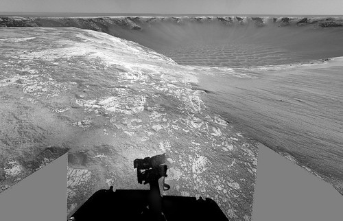
The view in the drive direction on Sol 1049.
Taken with the L2 Pancam.
jvandriel
Taken with the L2 Pancam.
jvandriel
Some interesting details from the latest update:
QUOTE
Opportunity continued scientific studies of a rock called "Santa Catarina" on the rim of "Victoria Crater." Scientists suspect that Santa Catarina may be a meteorite or a rock blasted out from beneath the surface of Victoria. Opportunity collected extensive measurements to determine the iron content of the rock using the Mössbauer spectrometer and will continue to do so during the coming week.
Other activities included analysis of cobbles nearby that may be similar to Santa Catarina. Based on the results, members of the science team will either decide to stay and continue investigating the rocks or drive toward the next promontory of Victoria Crater.
Other activities included analysis of cobbles nearby that may be similar to Santa Catarina. Based on the results, members of the science team will either decide to stay and continue investigating the rocks or drive toward the next promontory of Victoria Crater.
I was thinking those rocks looked pretty shiny. I was wondering if they could be meteorites that were left behind as the material surrounding them eroded. They've imaged several of them now:

A little L456 false-color:

I think the rocks to the right in that last close-up are considerably brighter than they appear in this rendering... the way they stretch those raw image JPGs loses a lot of brightness information, and it's impossible to get it back by "de-stretching". Caveat emptor.
A little L456 false-color:
I think the rocks to the right in that last close-up are considerably brighter than they appear in this rendering... the way they stretch those raw image JPGs loses a lot of brightness information, and it's impossible to get it back by "de-stretching". Caveat emptor.
I said a few posts back that I think they've found another meteorite here, it looked a lot like an iron meteorite to me... Perhaps Oppy has wandered into a "strewn field"... if so, I'm just surprised it didn't happen earlier to be honest.
fragments from the impactor that produced VC? Maybe?
Santa Catarina doesn't look like any meteorite I've seen before. It seems to contain a population of angular fragments and another population of very rounded ones. It, and the other nearby float have very different appearances and weathering characteristics, compared to other pieces of float we've seen. I wonder if they might have eroded out of the ejecta.
I see that Opportunity will be forced to go closer to that outcrop behind B3. I can't wait.
I see that Opportunity will be forced to go closer to that outcrop behind B3. I can't wait.
QUOTE (mhoward @ Jan 5 2007, 06:41 PM)
Looks like there is some interest in the float.
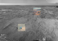
Indeed. Here is a polar projection including the location of all those cobbles, except for two of them supposely imaged on sol 1048 but not yet downlinked so I couldn't locate them.
FWIW, all these features, except the last one, are taking the names of cities related to Santa Catarina (a state in southern Brazil, light green in the picture). You can find them on the following picture too.
Click to view attachment
QUOTE (Tesheiner @ Jan 8 2007, 06:02 AM)
Indeed. Here is a polar projection including the location of all those cobbles, except for two of them supposely imaged on sol 1048 but not yet downlinked so I couldn't locate them.
Tesheiner, with your permission, I would like to use this map as a base to link to the 3D color images.
It will be a pleasure.
QUOTE (Tesheiner @ Jan 8 2007, 08:51 AM)
It will be a pleasure.
Thanks Tesheiner.
Here is the linked images from the map.
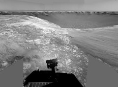
Here is the view in the drive direction on Sol 1051.
Taken with the L2 Pancam.
jvandriel
Taken with the L2 Pancam.
jvandriel
This is a "lo-fi" version of our main content. To view the full version with more information, formatting and images, please click here.