Help - Search - Members - Calendar
Full Version: MRO-HiRISE
Unmanned Spaceflight.com > Mars & Missions > Orbiters > MRO 2005
Pages: 1, 2, 3, 4
Sean
Hale Hills

Click thru to see the animated tour in 4k...


Stitched together from 2 DTM's.


PaulH51
QUOTE (Sean @ Jan 18 2017, 02:36 PM) *
Stitched together from 2 DTM's.

Can't get enough of these....
Sean
Hale Hills oblique...


rendered at 20000 x 10000


jasedm
To re-iterate, these are simply spectacular Sean - almost Ansel-Adamesque. Thanks for sharing them.
Sean
Thank you, quite addictive making them! The data is amazing...these renders are optimized to run on my machine so there is room to squeeze a little more detail out. There are lots of 'improvements' on the way...sky, colour and hopefully some kind of contextual compositional solution, if I can get my head around the myriad sources!
Art Martin
QUOTE (Sean @ Jan 19 2017, 12:25 PM) *
Thank you, quite addictive making them! The data is amazing...these renders are optimized to run on my machine so there is room to squeeze a little more detail out. There are lots of 'improvements' on the way...sky, colour and hopefully some kind of contextual compositional solution, if I can get my head around the myriad sources!


I understand the addiction. Years back when I was knee deep in the Microsoft Flight Simulator I found that users could add photorealistic scenery to areas and found DEM files from NASA and aerial photography shots from my county and combined them together to make the Phoenix area I was always flying over more realistic. The results were stunning. Suddenly the mountains and riverbeds looked exactly like reality and I began creating 3d buildings and objects, taking photos of their exteriors and wrapping them over the vertices. I spent months adding more and more. It eventually ended up a side business as people convinced me others would buy my work. It never was about the profit though. Was about the creativity it unleashed. A major addiction when it all comes together. Your work is wonderful.
Sean
Thanks for the story Art and given that your compliment means a lot!

I suppose it has something to do with making these inaccessible places tangible in some way, there is a visceral thrill when the elevation data & satellite imagery come together. Suddenly it is a place.

Here is a best quality available video of RGB pass from the Mounds in Ganges Chasma...


Sean
Now able to render at full available texture resolution!

A small breakthrough which might only result in a tiny perceptible qualitative improvement given compromises on elevation data...


...shots closer to models would hold up better though.


Sean
Here is RGB data mapped to 3D model to show parallax...


Sean
Culled this animation from a 9 DTM strong swathe of Mt Sharp... too wieldy to be productive yet so the following uses only 1 DTM

click thru to see the video...


http://www.uahirise.org/dtm/dtm.php?ID=PSP_009149_1750


Sean
Hematite Ridge portrait

5 DTM's at full texture res, 12k x 6k work in progress so please forgive the misalignment!


Sean
Sharp Slope

Click thru for the video...


Sean
Here is a link to a 450 megapixel test render of

Hematite Ridge

over at Gigapan.

Rendering at this level shows up some errors in alignment & textures ( not loading ) but is a good prep for upscaling to 65k pixel output
climber
Any chance you point out where's Oppy or where she'll enter the scene? Thanks
Sean
Here is a link to another Gigapan 450 megapixel extravaganza...

Mount Sharp Northwest Flank

And the Flickr version...


I was quite aggressive culling the DTM borders to conform to the chosen viewing angle.

Lots of work in Photoshop to balance out the jigsaw of exposures.

Each of the 5 DTM's were rendered separately, the foreground render then acted as a guide for conforming the rest to the base Mt Sharp render which is visible in the background crater rim and the upper left of the image. A depth pass was used to introduce atmosphere and soften transitions.

An amazing dataset!
scalbers
QUOTE (climber @ Jan 24 2017, 09:15 PM) *
Any chance you point out where's Oppy or where she'll enter the scene? Thanks

I've had some luck studying these with the route maps and another site where you can zoom into HIRISE (though it is offset a bit): http://curiosityrover.com/rovermap1.html
I can surmise for Curiosity that it will enter soon at the right edge of Sean's neat Hematite Ridge rendering, about 40-45% of the way between top and bottom.
Sean
You mean Curi, surely? smile.gif

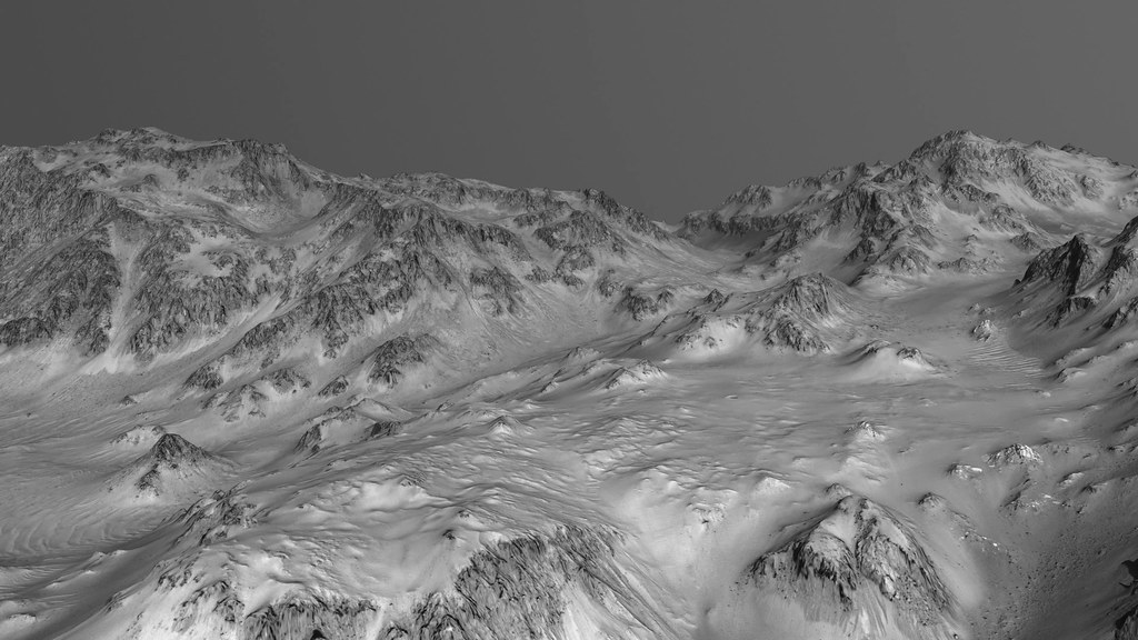
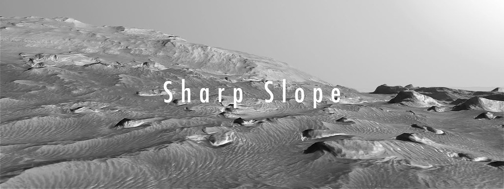
In the most recent Gigapan you can see Murray Buttes at the bottom center right of the image, tracing the route up toward the natural break in the dune field to the left of Ireson hill you can almost discern a path leading up to Hematite Ridge. In time I will make a version with the notional route.

QUOTE (climber @ Jan 24 2017, 09:15 PM) *
Any chance you point out where's Oppy or where she'll enter the scene? Thanks


In the first Gigapan rendering, Hematite Ridge, Curi's current position near Ireson Hill is just above the center stage right.

QUOTE (scalbers @ Jan 24 2017, 09:35 PM) *
I've had some luck studying these with the route maps and another site where you can zoom into HIRISE (though it is offset a bit): http://curiosityrover.com/rovermap1.html
I can surmise for Curiosity that it will enter soon at the right edge of Sean's neat Hematite Ridge rendering, about 40-45% of the way between top and bottom.
climber
Thanks and haha! Yes Cury, don't ask me why? May be Oppy=hematite for the last 13 years wink.gif
vjkane
The Gale Crater movie is perhaps the most awesome rendering of planetary image data I've seen. Thank you! It really brought the places Curiosity is exploring to life, which the overhead images don't.

If you ever have the time and inclination, it would be fascinating if the movie could retrace the Rover's journey.
Sean
Thanks vjkane, although to be fair there have been awesome animations using the same data over on Youtube since 2010.

I do have a nice 4k animation cooking at the moment but its going to take a while before it is ready.

In the meantime here is another take on the HiRISE coverage of Mt Sharp...


and the 450 megapixel Gigapan version...

Mount Sharp Northwest Flank 2


nogal
I grabbed a crop of Sean's "Mount Sharp Northwest Flank" (from Gigapan) and roughly marked Curiosity's route up to sol 1589 (green), it's current position (yellow star) and the latest "notional route" from JPL (red). Hopefully it will be helpful. Sean's work has added another dimension to my awe for this mission.
Fernando

Click to view attachment
Sean
Thanks Fernando. The wide field view of Curi's journey is a sight to behold!

So my plan is to image the entire mission zone along with the route so far & notional route, in as big an image as Gigapan will host, I'm not sure what their upper limit is. I think Photoshop will only go to 65k pixels square.

The trick will be to get a good angle without making the quilt-work of DTM's too obvious against the lores mesh of Gale Crater.
Sean
'Bob'

Here is a 4k video covering a 4 DTM swathe of Mt Sharp


Each DTM was rendered separately then combined in After Effects to blend variable exposures.
Sean
Spirit Zoom...click thru for video


Blending 3 layers of 2x HRSC sets & 1x HiRISE set


Sean
Inflation Features in Phlegra Dorsa


Dunes SW of Xainza Crater


Colorized texture pass based on RGB strip


monty python
THANK YOU for the "SPIRIT ZOOM". It really gave me context of the area, and how fortunate we were to have those interesting hills nearby to make the mission great!
Sean
Thanks Monty P

More colorized dunes based on HiRISE RGB strip...


climber
Sean, you're totally changing our view of Mars. You're a pioneer. You're a new explorer. Thank you SO much...
scalbers
Interesting video from HIRISE images here with a variety of quick flyovers: https://www.wired.com/2017/03/stunning-vide...-together-hand/
Sean
HiRISin'

Click thru for video...


Celebrating 50,000 orbits


nprev
ohmy.gif ...I'm gonna need a loan to make the requisite deposits in the swear jar.

Incredible work, Sean; thank you!!!
climber
See post #79! Thank you (Frantz-kly)
brellis
Majestic!
Sean
Thankee!

Arabia Terra

Click thru for video...


And some 4k stills...


Sean
Terby Crater

Click thru for video...


Sean
Faulted Layers in Meridiani Planum

Click thru for a video...


Re-rendered in 4k


scalbers
That's nice Sean - it's remarkable how regular the tilted layers are. Have you done anything around the North Polar layering, similar to these examples?

http://www.uahirise.org/dtm/dtm.php?ID=PSP_001738_2670

http://www.uahirise.org/dtm/dtm.php?ID=PSP_010008_2630

http://photojournal.jpl.nasa.gov/catalog/PIA21465

Elsewhere, here is an interesting cluster of mesas that you might have done? http://www.uahirise.org/dtm/dtm.php?ID=ESP_026040_1880

I gather this is the Arabia Terra rendered in post #85 - pretty neat: http://www.uahirise.org/dtm/dtm.php?ID=PSP_002047_1890
Sean
Thanks Steve.

Thanks for the links & suggestions, I really appreciate the feedback.

I have those polar layers in the queue... I will move them up!

The mesas are also on the to-do list but I want to put them in context so its a little more work.

I have updated the Arabia Terra post with the source link.

Faulting within the Layered Deposits in Candor Chasma

Click thru for a video...


Sean
Lava Vent


PaulH51
Simply Stunning Sean smile.gif
Sean
Thanks Paul

Lava Vent

Click thru for a 4k video...


Sean
Layered Rock

Click thru for 4k video...


lyford
Delurking to say ohmy.gif ohmy.gif ohmy.gif!!!!!
Sean
rolleyes.gif

Light-Toned Outcrops in Noctis Labyrinthus

Click thru for a 4k video...


Sean
Ladon Valles


Sean
Palikir Crater


Click thru for a 4k video...


Since uploading the video I felt it moved too quickly, so here is a longer cut...


Sean
Ladon Valles

Click thru for a 4k video...


*updated with much higher bitrate to accommodate detail


Sean
Domoni Crater

Click thru for a 4k video...


Here is Domoni in full...


scalbers
Interesting to see such a deep bowl shaped crater at about 0:58 time in the Ladon Valles video. Looks to be consistent with the higher depth/diameter ratios for small craters mentioned in this online reference, possibly around 0.3? Intricate terrain overall.

Nice music with Domoni too.
This is a "lo-fi" version of our main content. To view the full version with more information, formatting and images, please click here.
Invision Power Board © 2001-2024 Invision Power Services, Inc.