kenny
Mar 24 2010, 09:01 PM
QUOTE (Tesheiner @ Mar 24 2010, 04:12 PM)

Here's the view looking back at the tracks.
We knew this 20km was coming up, but seeing it there pointed out by Tesheiner, the impact is more than the intellectual knowledge.... can 20km really be true? 20km !!! Gasp!
walfy
Mar 24 2010, 10:02 PM
Probably a dumb question, but does the 20km include all the wheel spinning when Oppy got trapped in Purgatory?
Tesheiner
Mar 24 2010, 10:04 PM
No it doesn't.
Check the odometry included in the status reports covering that timeframe.

Edit: what is does include is the wheel turns when the rover is doing a turn-in-place manouver; the rover spins around with no net advance but only a heading change.
Bobby
Mar 25 2010, 10:43 PM
I have a question about the Batteries on Opportunity? I thought I read a while back
that they were designed for 2,000 recharges. If they were then where are we at now
for both rovers???

djellison
Mar 26 2010, 12:17 AM
Look for the JPL tech reports. No one designs batteries that last 2000 cycles then suddenly stop working. THey have had a very slow gradual degradation in performance but still have a significant proportion of their orig. capacity remaining.
SFJCody
Mar 26 2010, 06:55 PM
Patiently awaiting tosols post driving images...
SFJCody
Mar 26 2010, 08:14 PM
And here they are!
 http://qt.exploratorium.edu/mars/opportuni...00P2402L6M1.JPG
The twin craters look a bit more dramatic than I had expected.
Sunspot
Mar 26 2010, 08:14 PM
Tesheiner
Mar 26 2010, 08:19 PM
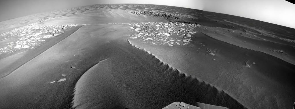
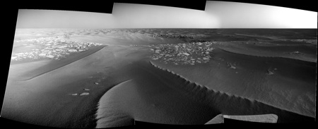
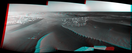
And here's a quick & dirty navcam mosaic.
Click to view attachmentNow, it's time to make a polar view and register it on the route map...
done.
A quick look on the mobility info tells the drive was 60+ meters and we are around 70m from the craters.
QUOTE (SFJCody @ Mar 26 2010, 09:14 PM)
The twin craters look a bit more dramatic than I had expected.
Agree.
climber
Mar 26 2010, 08:23 PM
.../... meanwhile, Eduardo's working on the route map .../...
Stu
Mar 26 2010, 08:37 PM
Click to view attachmentClick to view attachmentLooks like there is some pretty interesting rock exposed over there, Oppy... go get!
Explorer1
Mar 26 2010, 08:46 PM
Deeper then we expected, that's for sure.
Is 1 or 2 more drives till arrival a good estimate?
ElkGroveDan
Mar 26 2010, 08:52 PM
QUOTE (Stu @ Mar 26 2010, 12:37 PM)
Looks like there is some pretty interesting rock exposed over there,
Apparently Hadrians Wall went a lot farther than anyone imagined.
Stu
Mar 26 2010, 08:54 PM
Never try and "estimate", just
look forward to. The moment you put an estimate on anything like this, Mars thinks "Ha! That's what YOU think!" and then gives you a Benny Hill slap on the head then runs away, giggling. Just enjoy the ride!
Stu
Mar 26 2010, 08:56 PM
QUOTE (ElkGroveDan @ Mar 26 2010, 08:52 PM)
Apparently Hadrians Wall went a lot farther than anyone imagined.
Love that!

Hadrian's Wall is pretty impressive, but his Conservatory was a
masterpiece...
Tesheiner
Mar 26 2010, 09:36 PM
QUOTE (climber @ Mar 26 2010, 10:21 PM)
If I understand Eduardo's Oppy's route map, on Sol 2188, Oppy reached the most western point of her whole journey... since she'll rove east from now on.
I was right now looking to the map in GE and saw the same thing. Well, first SE for some hundreds of meters and then finally due east.
And if you have a look to the map, specially the GE version, there's a sudden drop in the ripples size aprox. 200m after the craters; IMO, this may be due to a change of the wind flow in that area probably because of a different, mmm, angle (?) of the terrain.
Edit: moved to the main thread.
SFJCody
Mar 26 2010, 09:52 PM
More driving scheduled for sol 2194.

I'm amazed she has enough energy!
climber
Mar 26 2010, 10:01 PM
No energy needed here, we're just going down...

Bill Harris
Mar 26 2010, 10:36 PM
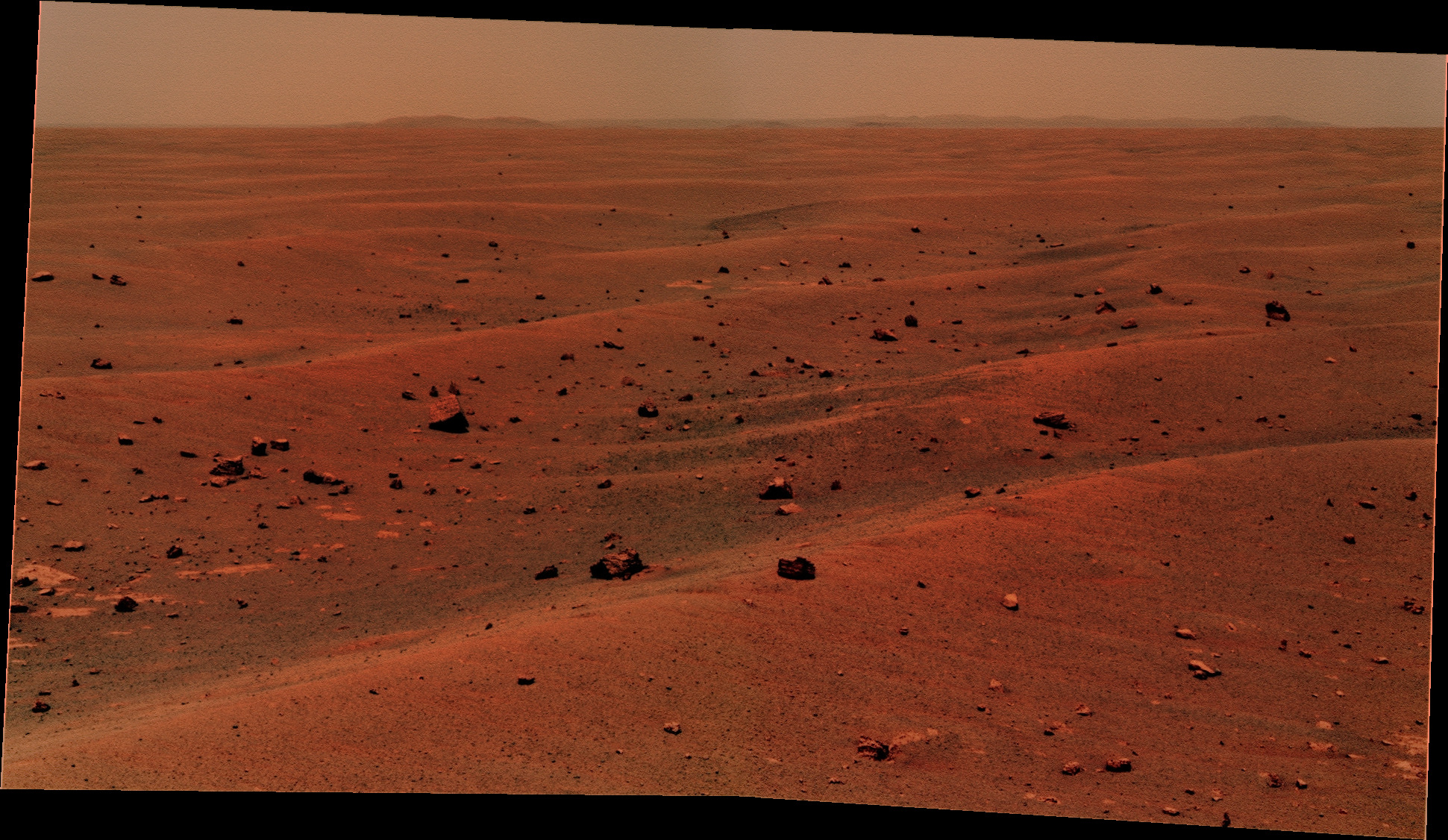
Here are todays approach Pancams (1P322876942EFFAE00P2402R1M1, et al, Sol 2193) panorama'd, exaggerrated 3-fold and referenced to a HiRise orbital image.
Driving tomorrow? Good!
--Bill
Tesheiner
Mar 26 2010, 10:51 PM
And by this time tomorrow, if not earlier, we'll probably have official names to them.
fredk
Mar 26 2010, 11:05 PM
I think we're still not seeing much of the far crater of the twins. Here's a crude estimate of where the two craters are (the far ellipse should be lower):
Click to view attachmentAmazing how we're basically on top of the twins and still can't see their full extent.
Mosaic is from Stu.
nprev
Mar 26 2010, 11:45 PM
Not much in the way of ejecta aprons, it seems. Odd. Then again, Victoria didn't have much of one either.
Bill Harris
Mar 27 2010, 01:36 AM
> Not much in the way of ejecta aprons, it seems.
This is the great puzzle here. One would assume that the Twins are older and that the ejecta rubble has simply weathered and eroded. But looking at the ejecta at Concepcion, expecially the NE ray, the weathered, still in-place material has a significant volume to be blown away without leaving a trace. By "without a trace", I mean no effect on the pre-existing ripples (except withing a few meters of the crater rims). I'd suspect that we may see a difference in the distribution of the blueberies since they would tend to be left behind after the evaporite matrix is weathered and eroded away.
There is more to this erosional process than what firrst meets the eye.
> Then again, Victoria didn't have much of one either
But it does. Eroded, very smooth, unrippled, it is clearly a blanket over the pre-impact terrain.
--Bill
brellis
Mar 27 2010, 05:41 AM
hi all,
I tried to search for the answer to these questions, couldn't find 'em.
How many kilometers have the test rovers driven?
Have they tried to drive a test rover on a long trek like this?
Did they attempt anything like such a drive during the mission development stage?
Thanks, and as always, GO TEAM!!
djellison
Mar 27 2010, 07:19 AM
Similar question has been asked before - but I think the answer was a 'don't know'
As for development? They were designed for 600 - 1000 m so testing them for 20km+ was never going to be a requirement.
nprev
Mar 27 2010, 07:38 AM
I think maybe a more illuminating set of questions would involve the heritage of the drive system components & whatever testing they were subjected to if they've been used for any terrestrial applications.
Certainly Sojourner must have provided considerable pathfinder (ta dah, dah!) data for the MERs, but obviously all the moving parts are bigger, stronger & faster. Likewise, MSL's drive system is an evolute of MER; the questions are in what specific ways?
(OT for this thread, but very interesting. The engineering results from MER will probably be at least as valuable in their own way as the science over the long term.)
AndyG
Mar 27 2010, 11:05 AM
QUOTE (nprev @ Mar 27 2010, 07:38 AM)
The engineering results from MER will probably be at least as valuable in their own way as the science over the long term.)
That sounds dangerously close to suggesting you'd like a future MER sample/return mission!
Andy,
still unable to reply with FF 3.6.2 ...
Ant103
Mar 27 2010, 12:22 PM
Hi,
Back from a break (I think you can understood that sometimes we need to rest) of processing pictures, I started to make again (and again) colors of Oppy.
Much more interested by the pretty amazing view of Endurance rims on the horizon, like on Sol 2169 :

or Sol 2191
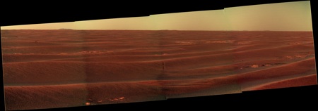
And here is the view of the approaching of "Twin Craters" (no names so I presume ?)
Stu
Mar 27 2010, 03:44 PM
Good work, Ant, good work...
Tesheiner
Mar 27 2010, 05:55 PM
According to the mobility info, we are there! Actually, 10m N of the west crater.
Can't wait for the images!
Sunspot
Mar 27 2010, 06:14 PM
WOW that was quick, doesn't seem long ago they were 300m away.
ngunn
Mar 27 2010, 07:39 PM
QUOTE (Bill Harris @ Mar 27 2010, 01:36 AM)
> Not much in the way of ejecta aprons, it seems.
This is the great puzzle here.
I seem to remember there's thought to be a certain thickness of Meridiani stuff (several metres, I can't remember how many) which erodes down until the covering of residual blueberries is dense enough to halt the process. Any crater too small for it's ejecta apron to exceed that critical thickness might be expected to erode down all the way to the original surface, leaving (as you suggested) an excess of blueberries as it's only trace. I wonder what that critical crater size is?
fredk
Mar 27 2010, 07:46 PM
fredk
Mar 27 2010, 08:07 PM
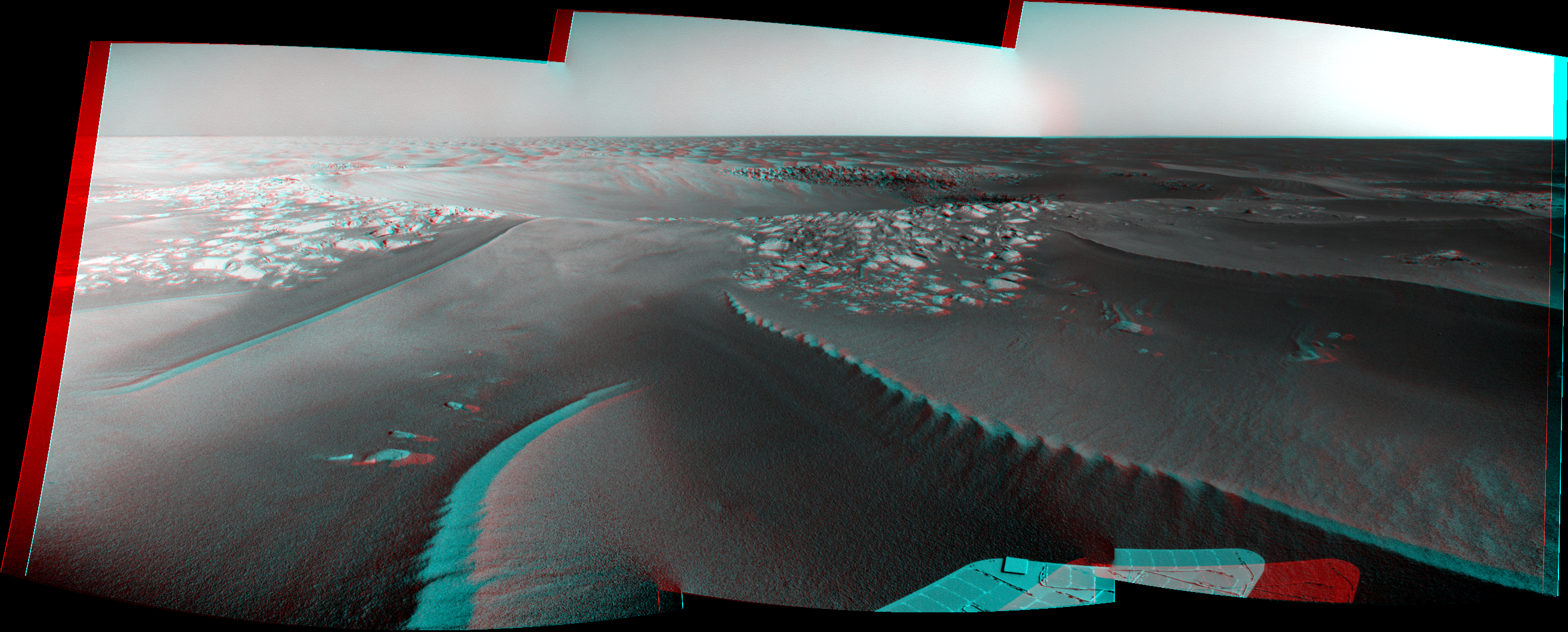
Isthmus in 3D:
Click to view attachmentStill hard to make out the east twin.
Mirek
Mar 27 2010, 08:37 PM
My first panorama on UMSF:
Twin Craters
Stu
Mar 27 2010, 08:43 PM
Thought so... some interesting structure down there...
Click to view attachmentAnd welcome Mirek, great pan!
Bill Harris
Mar 27 2010, 08:49 PM
Wonderful. She got there tosol just before sunset.
On today's Navcams, I see new ripples overlying eroded ejecta and possibly overlapping old ripples. This is from the very first look at a few images, but it's an eyebrow-raiser for me WRT ripple formation time constraints and morphology. Just a thought, I'm going to anxiously await more pictures before getting too excited.
Another puzzler is why "Hadrian's wall" in the West Twin is sitting so crisp and sand-free.
Just a thought...
--Bill
ngunn
Mar 27 2010, 10:54 PM
I'll be following your commentary on the sequence and timescale of the different processes with great interest Bill. In the meantime there's one thing that already bothers me about this site. The eastern crater appears to be lower than the western one. I could understand that if the eastern crater formed first and the western impact went into the eastern crater's raised ejecta blanket. But it's hard to imagine that the two didn't form almost simultaneously, from the same meteoroid. Could there then be enough of a time interval for the difference in levels to be accounted for in this way? I seriously doubt it. The odds against two separate, unrelated events must be huge. So what's going on? I'm flummoxed.
marsophile
Mar 28 2010, 12:04 AM
QUOTE (ngunn @ Mar 27 2010, 03:54 PM)
The eastern crater appears to be lower than the western one.
The "eastern" crater is actually SE of the west crater. Isn't the terrain sloping down towards the south at this point?
http://marsrovers.jpl.nasa.gov/newsroom/pr.../20100324b.htmlQUOTE
Now, the rover is approaching a portion tilting slightly southward.
fredk
Mar 28 2010, 12:59 AM
The general tilt of the terrain is still extremely subtle. I think what we may be seeing with the Twins is that the rim between the two craters (ie the isthmus) is higher than the rest of the rims. That makes it look like East Twin is lower than West from our current viewpoint.
brellis
Mar 28 2010, 01:46 AM
Auto-Nav software allows more precise finishing points versus crater edges?
Ant103
Mar 28 2010, 01:48 AM
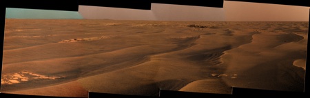
The navcam pan of Sol 2194. Yes ! We see clearly the Eastern Crater now
And anaglyph because sometimes it's just an obligation to have it :
Bill Harris
Mar 28 2010, 02:42 AM
QUOTE
one thing that already bothers me about this site. The eastern crater appears to be lower than the western one. I could understand that...
There are slight differences in each impact. Different masses of each impactor, millisecond delays in the timing of the impacts and inhomogeneities in the underlying strata can all add up. The craters are similar, but not identical.
For example, in setting up a blast in a quarry or mine, the spacing of the shot holes, the amount of explosive used or a small (milliseconds) delay between individual holes going off can vastly atler the nature of the effects of the shot. A well-designed shot can fragment the rock and then cast the overburden in a specific direction. An impact is very similar to a mine blast. Both rely on a shock wave to distort and fragnent and move rock. My background in Geology touches upon mining, and I look at impacts as simply a bigga-boom...
--Bill
PS-- here is a good site with introductory material on impacts and impact structures:
http://www.impact-structures.com/understand.html
serpens
Mar 28 2010, 05:29 AM
QUOTE (ngunn @ Mar 27 2010, 11:54 PM)
The odds against two separate, unrelated events must be huge.
Actually if they were separate (unrelated) impacts then the probability that the second would hit next to the first crater is exactly the same as that it would impact in another particular position. I think we need to be careful not to make off the cuff correlations.
Explorer1
Mar 28 2010, 05:44 AM
I like to imagine it like flipping a coin. You flip it 10 times, and get heads each time. What is the chance the 11th flip will come up tails? Still 50/50.
We cannot rule out that they might be separate. Oppy's just arrived, who knows what will be found.
ngunn
Mar 28 2010, 08:47 AM
QUOTE (fredk @ Mar 28 2010, 12:59 AM)
That makes it look like East Twin is lower
QUOTE (Bill Harris @ Mar 28 2010, 02:42 AM)
A well-designed shot can fragment the rock and then cast the overburden in a specific direction.
QUOTE (serpens @ Mar 28 2010, 05:29 AM)
the probability that the second would hit next to the first crater is exactly the same as that it would impact in another particular position
That probability argument, whilst true as stated, is also misleading and doesn't address the issue. So I'm going with either Bill's well-designed shot or Fred's optical illusion. If millisecond differences can indeed do the trick my money's on Bill because I think the asymmetry of the site was already apparent on the HiRise.
Two other things to mention which I'll try to dig out and come back to. Somebody posted earlier a possible explanation of the apparent asymmetry in terms of prevailing wind. EDIT:
http://www.unmannedspaceflight.com/index.p...st&p=157521And on the Hirise thread there are a couple of nice crops of other multiple craters in the vicinity. EDIT: posts 141 and 142.
Close examination of those might shed some light on the twins.
Bill Harris
Mar 28 2010, 11:08 AM
This is an illustration from the Impact Structures site of the ejecta surrounding a terrestrial twin impact, Azuara and Rubielos, in Spain.
http://www.impact-structures.com/spain/con...sy/pelarda.htmlhttp://www.impact-structures.com/images/imag034.jpg--Bill
AndyG
Mar 28 2010, 01:13 PM
QUOTE (fredk @ Mar 27 2010, 08:46 PM)
The isthmus runs through the centre of this frame
It's a while since I took O-level geography, but perhaps
arête would be a more suitable term? A sharp topographic ridge left between two areas of erosion.
Andy
Bill Harris
Mar 28 2010, 02:08 PM
It probably is a more accurate term, but "isthmus" is our informal name for this whatchamacallit.
Fooey. No new images this morning and she's having problems connecting with the relay satellite. Maybe by the "noon run"...
--Bill (on the edge of his seat)
fredk
Mar 28 2010, 02:29 PM
QUOTE (serpens @ Mar 28 2010, 06:29 AM)
the probability that the second would hit next to the first crater is exactly the same as that it would impact in another particular position.
But there are
way more "other particular positions" the second could hit that are far from the first than are adjacent to the first! So it's overwhelmingly likely that two unrelated impacts would be widely separated.
One thing I'd add to my raised-isthmus idea is that the west twin is larger than the east, so presumably had a more substantial raised rim, and so perhaps more of it's raised rim has survived than the east twin's, adding to the impression that west twin is higher than east.
I agree "isthmus" may not be the best term here, but I was inspired by other words we've been using related to the sea, eg capes/bays at Victoria.
This is a "lo-fi" version of our main content. To view the full version with more information, formatting and images, please
click here.