I think these views are easily the most dramatic from Oppy since she was aside Burns Cliff way back in December 2004.
You've come a long way, baby!
Full Version: To the Cape! (part 2)
Fantastic James! I can't wait until Opportunity gets a chance to 'touch' the wall.
Here's my artist's view of this iconic mission image.
Click to view attachment
I'm looking for a place to post the 19mb version.
Enjoy
Astro0
Here's my artist's view of this iconic mission image.
Click to view attachment
I'm looking for a place to post the 19mb version.
Enjoy
Astro0
QUOTE (Astro0 @ Jul 9 2008, 07:22 AM) 
Here's my artist's view of this iconic mission image.Enjoy
Astro0
Astro0
Alright you two, stop it, just STOP it! How are we meant to get any work done when you create masterpieces like that?! I've three big editing jobs on the go, talks to arrange, and then my day job to go to later, and you serve me up THAT to wander around and drool over!!! I can't stop scrolling around it, looking at all those lovely layers and beautiful boulders... Cruelty beyond measure!

Will we have a chance at some point of seeing the cliff face out of shadow? It is a magnificent panorama, but the lighting isn't exactly optimal.
Thx to all image contributors!
Thx to all image contributors!
The cliff faces almost due south, so at this time of year (southern midwinter) it is essentially permanently shadowed. Oppy would have to wait for summer to get a non shadowed shot and I think we'll be long gone by then.
James
James
Could there be an advantage in being in shadow? A more even illumination will play down the topography of the rock surface for sure, but that could make it easier to observe other features such as differences in colour and grain size.
From this new update:
As spring approaches, we'll be able to get closer to the cliff, but that will be a very slow process...
As far as imaging the cliff in full shadow, they did this very late in the afternoon on sols 1579 and 1580, using the open L1 filter setting to let in as much light as possible. Some of these shots show incredible detail:
http://marsrovers.jpl.nasa.gov/gallery/all...B0P2270L1M1.JPG
http://marsrovers.jpl.nasa.gov/gallery/all...B0P2271L1M1.JPG
http://marsrovers.jpl.nasa.gov/gallery/all...B0P2271L1M1.JPG
http://marsrovers.jpl.nasa.gov/gallery/all...B0P2271L1M1.JPG
QUOTE
With each move closer to Cape Verde, power to Opportunity's solar arrays has decreased as more of the promontory obscures the sky... The rover's next short advance toward the cliff will tilt its solar panels away from the Sun, limiting the amount of solar energy even more. Rover drivers will take great care to ensure that Opportunity stays out of the shadow cast by Cape Verde, which currently extends approximately 3 meters (about 10 feet) from the cliff face.
As spring approaches, we'll be able to get closer to the cliff, but that will be a very slow process...
As far as imaging the cliff in full shadow, they did this very late in the afternoon on sols 1579 and 1580, using the open L1 filter setting to let in as much light as possible. Some of these shots show incredible detail:
http://marsrovers.jpl.nasa.gov/gallery/all...B0P2270L1M1.JPG
http://marsrovers.jpl.nasa.gov/gallery/all...B0P2271L1M1.JPG
http://marsrovers.jpl.nasa.gov/gallery/all...B0P2271L1M1.JPG
http://marsrovers.jpl.nasa.gov/gallery/all...B0P2271L1M1.JPG
Stunning photo James - I think it's about time Mr Squyres had a feature named after him as he has got to be the king of Mars Geology
how about a vote for 'Squyres Cliff' - a fitting tribute to SS & team
how about a vote for 'Squyres Cliff' - a fitting tribute to SS & team
As my understanding is - the shadow of the cliff (and therefore low solar energy) will prevent Oppy from doing lots of interesting work with its IDD ??
Other problems could also prevent it - unpassable terrain for example. How good are the chances to reach the cliff ?
Robert
Other problems could also prevent it - unpassable terrain for example. How good are the chances to reach the cliff ?
Robert
From the latest update:
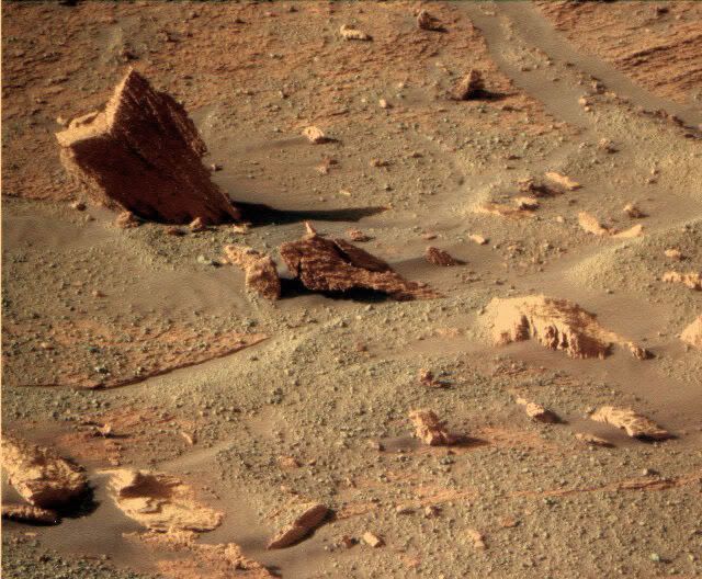
Anyone hazard a guess as to which rock is Nevada?
QUOTE
Next week's plans call for Opportunity to bump forward to a point only a few meters away from the cliff face to take high-resolution images. If possible, Opportunity will also conduct scientific studies of an outcrop target called "Nevada" (so named because of a rock next to it which has a shape reminiscent of the outline of the state of Nevada) using instruments on the robotic arm.
Anyone hazard a guess as to which rock is Nevada?
Here's my artist's view of this iconic mission image. I'm looking for a place to post the 19mb version.
Enjoy Astro0 [/quote]
 Astro0, your image is just incredible and so beautiful !!!
Well... I'm so sorry to arrive "after the battle" with only a black & white Navcam (calibrated and cleaned) version...
Anyway... I hope you will enjoy it !
Click to view attachment
Enjoy Astro0 [/quote]
Astro0, your image is just incredible and so beautiful !!!Well... I'm so sorry to arrive "after the battle" with only a black & white Navcam (calibrated and cleaned) version...
Anyway... I hope you will enjoy it !
Click to view attachment
QUOTE (fredk @ Jul 9 2008, 05:31 PM)
This one, mebbe?
Yeah...been looking at that one for awhile, now. If I found that on Earth, first things I would think of are 1) gypsum crystal, 2) aragonite, 3) sand-encrusted exotic silicate, like kunzite. The truth is probably far more mundane, but if it is in fact any of these minerals then there had to be considerable water present to form it at all way back when.
I was wondering if it wasn't the bedrock closer in here:
http://marsrovers.jpl.nasa.gov/gallery/all...B0P2271L1M1.JPG
Right shape, but I guess a bit close in
http://marsrovers.jpl.nasa.gov/gallery/all...B0P2271L1M1.JPG
Right shape, but I guess a bit close in
This is my guess.
Click to view attachment
Click to view attachment
"Could there be an advantage in being in shadow? ..."
Yes, but. If the camera lenses were spotlessly clean, diffuse illumination would indeed have advantages. Only with the sun close enough to the field of view to cause actual lens-flares that interfere with visibility in the diffusely illuminated shadow would there be a problem. Unfortunately, post-dust-storm, the lenses are very un-clean.
When all else fails, and you think youi're going blind...... CLEAN YOUR GLASSES.
Unfortunately, the rovers can't.
QUOTE (edstrick @ Jul 10 2008, 10:01 AM)
Yes, but. Unfortunately, post-dust-storm, the lenses are very un-clean.
Thanks for that reply, but can you clarify something for me. What is the main problem with the dust on the lenses when it comes to taking shots in the cliff shadow specifically? Is it:
1/ simple obscuration causing too-low light levels in the camera, or
2/ interference from light scattered by the lens dust washing out the darker parts of the scene?
If the former there's not much to be done I suppose. But if it's the latter? Presumably it's normal to arrange for the lenses not to be in direct sunlight, and presumably indirect illumination of the lens dust will decrease the closer in we get to the shadowed cliff, so maybe the shadow images will get progressively better for that reason??
Please correct me if I'm hopelessly off-track.
"...What is the main problem with the dust on the lenses when it comes to taking shots in the cliff shadow specifically? Is it:
1/ simple obscuration causing too-low light levels in the camera, or
2/ interference from light scattered by the lens dust washing out the darker parts of the scene? "
I presume it's mostly the latter, though when dust on lenses was recently recent additions, and the camera looked up at relatively featureless sky, you could actually see out of focus globs of dust on the optics as shadows. When it's thick enough, it obscures light, and diffusely transmits it like Titan's atmosphere. But mostly, it's like driving toward the sun 20 min from sunset with a dirty windshield. Unfortunately, with the sun on the north side of the sky, it's the worst case, and its scattered glare is hard to avoid except in early morning or late afternoon, not the best time of day power-wise <regardless of other operating constraints> of the rovers.
Camera in shadow, means rover in shadow, means a big hit on Whrs.
The recent 4.30pm dusk panorama though, is an example of what can happen to help.
Doug
The recent 4.30pm dusk panorama though, is an example of what can happen to help.
Doug
"Camera in shadow, means rover in shadow, means a big hit on Whrs"
Bet you get cold, fast, too!
Bet you get cold, fast, too!
You get cold at night anyway
Would it really get that cold in the shadow and fast? I take it the rarefied martian air sucks at conduction and convection so the primary means of losing heat would be radiation. The rover's not that hot in the first place, so radiative cooling ought to be slow, no?
QUOTE (djellison @ Jul 10 2008, 11:55 AM)
Camera in shadow, means rover in shadow
If it's within the cast shadow of the cliff, yes. But if the camera's pointed NW in the morning or NE in the afternoon it should be sufficiently far from the solar azimuth to keep direct sunlight off the lens, no? Your post suggests that something like this tactic is already being adopted.
I suppose as the sky fills a smaller and smaller solid angle as seen by the lens you get down to a limiting situation where most of the remaining illumination of the lens dust is coming from sunlit parts of the rover itself. I'm not familiar enough with the rover geometry to know how significant that would be.
Anyhow, the pictures so far have been truly spectacular. Congratulations to the rover team, and thanks too for all the great processed images posted here. What a party!
One additional problem to add to ngunn's list is ccd bleeding. If you're trying to image shadowed areas of the cliff, and there are adjacent sunlit areas or sky, you can get severe bleeding ruining the image if you expose for the shadowed areas.
That reminds me: I assume you're talking about the sol 1579/80 L1 sequences. Using the rawid utility (which I found on these pages in the distant past), the 1579 sequence went from about 16:35 to 16:50 local time, and 1580 was about 15 minutes earlier.
But using Tman's filename decoder I get considerably later times: 17:45 to 18:00 on 1579 (and again 15 minutes earlier on 1580). My assumption is that rawid has gotten well out of synch, and that Tman's decoder is much closer to the truth. Can anyone clarify this?
If 18:00 is correct, that would definitely be after sunset for Oppy considering that she's in a hole, since even out on the plains the sun would set a bit before 18:00 local solar time near the winter solstice.
QUOTE (djellison @ Jul 10 2008, 10:55 AM)
The recent 4.30pm dusk panorama though, is an example of what can happen to help.
That reminds me: I assume you're talking about the sol 1579/80 L1 sequences. Using the rawid utility (which I found on these pages in the distant past), the 1579 sequence went from about 16:35 to 16:50 local time, and 1580 was about 15 minutes earlier.
But using Tman's filename decoder I get considerably later times: 17:45 to 18:00 on 1579 (and again 15 minutes earlier on 1580). My assumption is that rawid has gotten well out of synch, and that Tman's decoder is much closer to the truth. Can anyone clarify this?
If 18:00 is correct, that would definitely be after sunset for Oppy considering that she's in a hole, since even out on the plains the sun would set a bit before 18:00 local solar time near the winter solstice.
Hi
It was hard, long, but I finally "succed" to make this huge panoramic view of Cape Verde (there already are some vignetign and flares, in spite of my efforts ).
).

Various resolution can be found at the end of this page (summer page because of impossibility to update my webstite):
http://www.db-prods.net/blog/?page_id=151
And I've made two desktops, one for 4:3 screens, and other for 16:9.
1280
1440
So, time to have a break .
.
It was hard, long, but I finally "succed" to make this huge panoramic view of Cape Verde (there already are some vignetign and flares, in spite of my efforts
).Various resolution can be found at the end of this page (summer page because of impossibility to update my webstite):
http://www.db-prods.net/blog/?page_id=151
And I've made two desktops, one for 4:3 screens, and other for 16:9.
1280
1440
So, time to have a break
.QUOTE (Astro0 @ Jul 9 2008, 07:22 AM)
I'm looking for a place to post the 19mb version.
Here it is.

James (on behalf of Astro0)
QUOTE (fredk @ Jul 10 2008, 05:42 PM)
That reminds me: I assume you're talking about the sol 1579/80 L1 sequences. Using the rawid utility (which I found on these pages in the distant past), the 1579 sequence went from about 16:35 to 16:50 local time, and 1580 was about 15 minutes earlier.
But using Tman's filename decoder I get considerably later times: 17:45 to 18:00 on 1579 (and again 15 minutes earlier on 1580). My assumption is that rawid has gotten well out of synch, and that Tman's decoder is much closer to the truth. Can anyone clarify this?
But using Tman's filename decoder I get considerably later times: 17:45 to 18:00 on 1579 (and again 15 minutes earlier on 1580). My assumption is that rawid has gotten well out of synch, and that Tman's decoder is much closer to the truth. Can anyone clarify this?
From the pancam web I get 17:38 for the first picture in the 1579's sequence and 17:55 for the last one.

Thanks, Tesheiner. So it seems Tman's filename decoder agrees with pancam web to 5 minutes or so, which is very good. Also, Tman says that his decoder agrees well with MER Analyst's Notebook and the Mars24 Sunclock.
So that really was a late sequence!
So that really was a late sequence!
Here it is. James (on behalf of Astro0)
Thanks James.
I know you went to a lot of trouble to place that online for me.
Very much appreciated.
Cheers
Astro0
James (on behalf of Astro0)Thanks James.
I know you went to a lot of trouble to place that online for me.
Very much appreciated.
Cheers
Astro0
QUOTE (Tesheiner @ Jul 10 2008, 11:30 PM)
From the pancam web I get 17:38 for the first picture in the 1579's sequence and 17:55 for the last one.
Did you ever find out what "LST" there exactly means - is it LTST (Local true solar time)? According the differences to MER Analyst's Notebook until sol 1350 it could/should be. http://marsrovers.jpl.nasa.gov/gallery/all...8P2398R1M1.HTML from sol 1350 shows in the Notebook a difference of 2:45 minutes in the same direction.
QUOTE (Tman @ Jul 11 2008, 12:19 PM)
Did you ever find out what "LST" there exactly means - is it LTST (Local true solar time)?
I would say so because the "Starting LST" of the pancam L1 sequence on sol 1579 (on your attachment) matches exactly the LTST of its first image.
But that's just my guess.
Here we go again. Looks like some digging in to me.
http://nasa.exploratorium.edu/mars/opportu...B8P1317R0M1.JPG
Brian
http://nasa.exploratorium.edu/mars/opportu...B8P1317R0M1.JPG
Brian
QUOTE (BrianL @ Jul 12 2008, 10:28 AM)
Looks like some digging in to me.
If this is one of their "stress tests" to see how solid the surface is, this amount of digging in may still be acceptable since it supposedly represents the worst that could happen on that surface. On the other hand, maybe it is a red flag.
It looks like they drove forward and moved back a bit, so I'd guess test, or turn.
Doesn't seem to be any change from the rear hazcams that came down on 8 July.
There was no driving attempt on sol 1586, just a new rhazcam shot with slightly less compression.
> On the other hand, maybe it is a red flag.
My opinion too. Yellow flag perhaps.
> On the other hand, maybe it is a red flag.
My opinion too. Yellow flag perhaps.
With Wall-E getting all the media attention, I thought it was time people were reminded of the amazing story of a REAL robot hero, out there exploring another planet right now...
Click to view attachment
That's my submission for this coming week's "Carnival of Space" and it name-checks a few UMSFers so I hope they use it, and give those members some of the credit and appreciation their work deserves.
Click to view attachment
That's my submission for this coming week's "Carnival of Space" and it name-checks a few UMSFers so I hope they use it, and give those members some of the credit and appreciation their work deserves.
Oppy took this on SOL 1583 with the solar filter.
There is no so-by-sol commentary for Sol 1583 on the MER site (yet)
It looks like it took a picture of the sun being occluded by the top of the cape?
(this is not Demos of Phobos eclipse ??)
Click to view attachment
Cheers
There is no so-by-sol commentary for Sol 1583 on the MER site (yet)
It looks like it took a picture of the sun being occluded by the top of the cape?
(this is not Demos of Phobos eclipse ??)
Click to view attachment
Cheers
QUOTE (PDP8E @ Jul 13 2008, 09:48 PM)
It looks like it took a picture of the sun being occluded by the top of the cape?
Looks like it, I'm afraid CosmicRocker beat you too it though

Does anyone know what this is?
01588 p2679.17 62 62 0 0 4 128 pancam_dust_search_tau_mosaic_L8R8
01588 p2679.17 62 62 0 0 4 128 pancam_dust_search_tau_mosaic_L8R8
Well, while we wait, here's a continuation of the Quicktime VR movie from earlier. This is a cheat, since it adds Navcam images from a subsequent (similar) location. But it seems to hang together well enough if you don't look to closely, and it fills in more of the view.
Quicktime VR (3.8 Mb)
Quicktime VR (3.8 Mb)
An excellent successful "cheat"!
The view is fascinating real!
The view is fascinating real!
That QT is sensational, like being there...
Not as impressive, I know, but still quite a view, I think...
"Approaching The Cape"
BTW: anyone wanting to see some truly jaw-droppingly impressive 3Ds of mars should go here...
Mars Unearthed
Not as impressive, I know, but still quite a view, I think...
"Approaching The Cape"
BTW: anyone wanting to see some truly jaw-droppingly impressive 3Ds of mars should go here...
Mars Unearthed
QUOTE (fredk @ Jul 11 2008, 12:34 AM)
Thanks, Tesheiner. So it seems Tman's filename decoder agrees with pancam web to 5 minutes or so, which is very good. Also, Tman says that his decoder agrees well with MER Analyst's Notebook and the Mars24 Sunclock.
The LTST calculation from the filname code is now better adjusted with the available official data - first Image of the late sequence on sol 1579.
Pictures from the latest drive are at the exploratorium.
And the rear right wheel (left on the image) is digging in the sand: http://qt.exploratorium.edu/mars/opportuni...BFP1314R0M1.JPG
And the rear right wheel (left on the image) is digging in the sand: http://qt.exploratorium.edu/mars/opportuni...BFP1314R0M1.JPG
On your excellent route map, Tesheiner, it seems quite clear which area they should steer clear of, namely the down-flow of loose sand which even has some ripples in it. It seems there's a bridge across that down-flow a good deal further down, just off the large boulder that has come off the cliff. There, you can quite clearly see "stepping stones" across the down-flow, which might suggest that going close to the cliff and then along the face would lead to a position further down where they can move away from the face again.
Mike,
WOW - You rock!
Cheating never looked so good!
(you guys with the hyper image skills, just kill me)
Cheers
WOW - You rock!
Cheating never looked so good!
(you guys with the hyper image skills, just kill me)
Cheers
This looks odd:
http://qt.exploratorium.edu/mars/opportuni...BHP1392R0M1.JPG
http://qt.exploratorium.edu/mars/opportuni...BHP1392R0M1.JPG
Steering to the right, fully, with a big of dig-in.
This is a "lo-fi" version of our main content. To view the full version with more information, formatting and images, please click here.