Juramike
Jun 30 2008, 12:48 AM
QUOTE (Shaka @ Jun 29 2008, 08:24 PM)

Why is the rim shape so rare on Mars? Sand and wind and craters are everywhere; I'd wager the cape and bay shape is less than one in ten thousand.

Maybe the underlying strata that Victoria impacted are atypical?

[EDIT: Just saw Bill Harris' post. I KNEW we shoulda spent more time at Anatolia!]
Shaka
Jun 30 2008, 02:46 AM
We thrashed this one around during the trek south to Victoria. Some of us tried to apply the hypothesis that Meridiani craters had been buried and later exhumed.
But buried/exhumed craters are not likely as rare on Mars as cape-and-bay rims.
I tried to imagine a crater that filled with water while it was still hot, then froze and was buried. It was later exhumed, and, meanwhile, collapsed as the ice sublimated.
I've not yet seen any clear evidence to back this scenario.

I keep waiting for the paper that makes Vikky comprehensible.
Bill Harris
Jun 30 2008, 02:58 AM
QUOTE
I KNEW we shoulda spent more time at Anatolia!
Anatolia was one of the first of many wonder that Oppy came across after emerging from Eagle crater. At the time we prioritized the 90-day operational life of the rover, so it was reasonable that we didn't spend an inordinate amount of time there. And, short of having a track-hoe along to do serious excavation, I don't know how much could have been gained beyond Pancam views. I do wish we'd been able to have inspected a few more Anatolia Features on the traverse southward. If we do continue the traverse around Victoria, we ought to look at the Anatolia Feature that is intersected by the southeast crater rim.
My initial, and continuing, impression of the Anatolia Features is that they are solution cavities along joints (or rather, a joint system intermittently widened by solution cavities). That is, until more evidence comes our way...

--Bill
ngunn
Jun 30 2008, 09:23 AM
QUOTE (Juramike @ Jun 30 2008, 01:48 AM)
Maybe the underlying strata that Victoria impacted are atypical?
Well I had a go at explaining the capes and bays way, way back. I think it was my first venture into a Mars topic. Anyhow there are new people here now and the idea has never gone away so here it is once more.
I think there was an uneven layer of water-rich material below the presently exposed strata and that this was fluidised by the Victoria impact. This resulted in selective sapping and collapse of the original crater walls, leaving vertical cliffs untypical of impact craters (but frequently produced on Earth by undermining and removal of material). Much of the fluidised material would have ponded in the centre of the crater and subsequently wasted away by sublimation and wind erosion. There are a number of possibilities for the easily fluidised water-rich layer, including some recently proposed highly hydrated martian minerals, for which I'd have to hunt a bit for the reference.
Why so rare? You need an impact to occur bang on top of one of these super-hydrated deposits, located at just the right depth relative to the size of the impact.
OK folks, shoot it down (EDIT: or ignore it) all over again!!
briv1016
Jul 1 2008, 05:02 AM
No new images since Friday. Is something going on?
Tesheiner
Jul 1 2008, 06:32 AM
Images are being downlinked everyday but there might be a problem in the pipe between JPL and the public sites.
Not the first neither the last time it will happen.
Astro0
Jul 1 2008, 06:50 AM
Both Canberra and the Madrid DSN stations have MER1 Opportunity tracking passes scheduled this week.
We have one 65 minute pass happening just a few hours from now between 8.55-10.00 UTC.
It's an uplink, with a radio science downlink ("beep").
I agree with Tesheiner...not an unusual matter for there to be no updates over the 'weekend'.
Be patient, I'm sure our girl is OK.
Astro0
jamescanvin
Jul 1 2008, 07:24 AM
Yes, don't worry, the data is arriving in the tracking database as normal. As Tesheiner says, just a problem with the system that gets the images out to us, it's happened many times before. Jim needs to give something a kick.

To put your mind at ease here is a stamp from yestersol (1576) off the tracking site.
Click to view attachmentJames
Tesheiner
Jul 1 2008, 08:15 AM
Just found this entry on an
interview to S.S. by space.com. Nothing really new but it's good to know they are still sticking to the plan of touching the wall.
QUOTE
Once all that is done, the robot will be commanded to try and get even closer to the cliff both to improve the resolution of images taken and to get the instruments on the rover's robotic arm onto bedrock.
"Whether we'll be able to accomplish this or not, though, we don't know," Squyres added. "The terrain here is very steep, and we obviously don't want to venture so close to the cliff that we're in its shadow. So we'll see."
Juramike
Jul 1 2008, 04:21 PM
QUOTE (Bill Harris @ Jun 29 2008, 10:58 PM)
My initial, and continuing, impression of the Anatolia Features is that they are solution cavities along joints (or rather, a joint system intermittently widened by solution cavities). That is, until more evidence comes our way...
If the joints were created or modified by solution it seem reasonable to hope that there might be evidence of deposits at the rock-atmosphere interface. Who knows? Maybe some of the rocks that previously lined the cracks in Victoria crater and then tumbled out will have some type of deposit visible?
I think it would be really cool to stick Oppy's arm deep into one of the accessible cracks and get an APXS and Mossbauer measurement to compare with the "normal" exposed cliff face. That might furnish a hint of underground solution transport since the crack formed.
"Put your hand in the box...."-Mike
djellison
Jul 2 2008, 11:30 PM
There's a burp in the imagery pipeline somewhere obviously - the people that need to know, now know.
TheChemist
Jul 2 2008, 11:54 PM
QUOTE (Juramike @ Jul 1 2008, 07:21 PM)
"Put your hand in the box...."
-Mike
I gather we 'll have an APXS of
spice soon ...
DFinfrock
Jul 3 2008, 03:26 AM
QUOTE (TheChemist @ Jul 3 2008, 12:54 AM)
I gather we 'll have an APXS of
spice soon ...
At the other end of the planet, I sure hope Phoenix's scoop isn't mistaken for a
thumper.

Tesheiner
Jul 3 2008, 06:43 AM
QUOTE (djellison @ Jul 3 2008, 01:30 AM)
There's a burp in the imagery pipeline somewhere obviously - the people that need to know, now know.
I just hope it's solved soon, otherwise we'll probably be without the daily MER "fix" until after the US holidays.
On a different topic, I just checked the planned sequences to find that Opportunity is scheduled to move on sol 1582; that will be this sunday.
To the Cape!

peter59
Jul 6 2008, 09:52 PM
Exploratorium is Back Up. Woo hoo!!
Floyd
Jul 6 2008, 10:02 PM
peter59 you just beat me to it. I was starting to think of the old "If a tree falls in the forest and no one hears it..." as applied to spacecraft: Does a spacecraft exist if UMSFers don't see the relayed pictures? Spirit and Opportunity were fading like the Cheshire Cat--not gone, but just starting to fade.

djellison
Jul 6 2008, 10:39 PM
The blockage is free, but there;s a backlog we're missing. Hopefully it will filter thru.
fredk
Jul 6 2008, 11:15 PM
Really good to see fresh pics again. It looks like tosol's (1582) drive was a short drive away from Verde:
http://qt.exploratorium.edu/mars/opportuni...B2P1213L0M1.JPG
Tesheiner
Jul 7 2008, 10:03 AM
> The blockage is free, but there;s a backlog we're missing. Hopefully it will filter thru.
I hope so. There're a lot of "juicy" pictures on this missing batch: Half of the latest mosaic and the whole superres shots.
peter59
Jul 7 2008, 03:50 PM
djellison
Jul 7 2008, 04:29 PM
Reading
http://nasa.exploratorium.edu/mars/opportu...m/2008-07-07/... scanning... found 410 new images.
Yeah - that oughtadoit
Doug
Oh wow.... seriously, how beautiful a world is this, when it can show us such wonders as these...
Click to view attachmentEven better in
3D...
... and
this one too...
... and another shard like
this isn't something Oppy wants to be under when it crumbles and falls off the cliffside, is it?!?!

CryptoEngineer
Jul 7 2008, 07:17 PM
QUOTE (Stu @ Jul 7 2008, 11:33 AM)
Oh wow.... seriously, how beautiful a world is this, when it can show us such wonders as these...
I hope Oppy spends some time examining these fallen blocks - they are samples delivered
from parts of the cliff we can't reach directly.
ce
nprev
Jul 7 2008, 09:02 PM
...shee-yit...
Mind-blowing is all, Stu, thank you!!! Burning question is how such apparently delicate blade-like extrusions could survive a fall from the cliff. Is it due to the gentle gravity, or did they grow out later from atmospheric precipitates? Either possibility seems extraordinary. The third is selective weathering, which would imply significant compositional differences between layers...again, very, very interesting, and difficult to explain in detail without better data on past conditions.
What a site!
Juramike
Jul 7 2008, 09:09 PM
I wonder how friable the exposed rocks are?
Those rocks in the images Stu posted look like they've been windblasted and eroded to the point like they are fine layers of phyllo dough ready for baklava.
One gentle push and they'd all go *poof*....
('Course, they survived the impact when they fell OK). How come we don't see more chunks? Did these bounce to their present position?
It's kinda hard to tell, but it looks like they got eroded before they fell away from the cliff. But the horizontal layering on the perpindicular rock in the image looks suspect.
-Mike
[EDIT: Ha! Nick beat me to it with the erosion questions!]
fredk
Jul 7 2008, 09:22 PM
QUOTE (Juramike @ Jul 7 2008, 09:09 PM)
'Course, they survived the impact when they fell OK.
My impression, for what it's worth, was that it's been a long time since they fell. They may have been much larger when they fell, and this is all that's left after millenia of wind erosion.
Ant103
Jul 7 2008, 09:30 PM
QUOTE (djellison @ Jul 7 2008, 06:29 PM)
Reading
http://nasa.exploratorium.edu/mars/opportu...m/2008-07-07/... scanning... found 410 new images.
Yeah - that oughtadoit
Doug
Really
big
I am working on this panorama, it's hard. And a lot of work is waiting for me
Mmm, tomorrow, it's time to have a break
Here is a preview of a part of the upcomming big pan of Cape Verde

.

Stu : your anaglyphs are astounding.
Juramike
Jul 7 2008, 09:45 PM
QUOTE (fredk @ Jul 7 2008, 05:22 PM)
My impression, for what it's worth, was that it's been a long time since they fell. They may have been much larger when they fell, and this is all that's left after millenia of wind erosion.
So the question is: If these blocks down here have fragile exposed sheet-like structures after being eroded by wind, shouldn't the cliff faces also have fragile sheet-like structures?
Are they in the same erosion environment?
Or are the cliff faces too high to have been subjected to millenia of bouncing grains. Maybe the foot of the cliff will have these??
QUOTE (Ant103 @ Jul 7 2008, 10:30 PM)
Stu : your anaglyphs are astounding.
Thanks, that means a lot coming from one of our foremost Imagemages...
Here's
another one...
fredk
Jul 7 2008, 11:05 PM
QUOTE (Juramike @ Jul 7 2008, 09:45 PM)
Maybe the foot of the cliff will have these??
I think you can see them at the foot of the cliff in some places, like near the left side of the image I added to
this post.
jamescanvin
Jul 7 2008, 11:34 PM
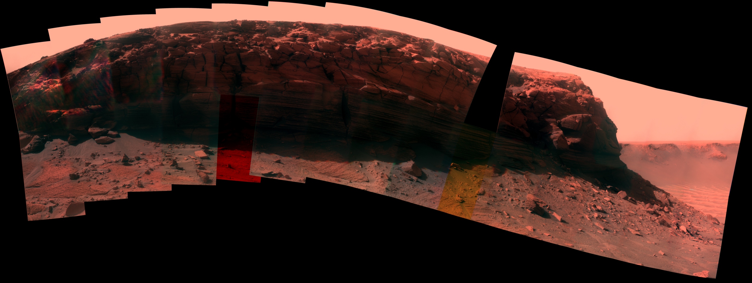
Completed pan of Cape Verde, what a view!


James
That's gorgeous James, absolutely gorgeous...
One final close-up of the luvverly, luvverly layers before I head off to bed... up again in 5 hrs...
Click to view attachment
Juramike
Jul 8 2008, 02:44 AM
Beautiful work, James!
I just spent some time slowly panning back and forth across your full res image....Imagining trying to climb the cliffs, looking for handholds and foot holds, maybe whipping out a rock hammer and chipping at some layers.
Your mosaic really brings Mars closer!
Juramike
Jul 8 2008, 02:46 AM
QUOTE (fredk @ Jul 7 2008, 07:05 PM)
I think you can see them at the foot of the cliff in some places, like near the left side of the image I added to
this post.Oh yeah!! And looking at the big mosaic it looks like the lower sets of layers really got eaten into by the wind.
Curious to know if those particular layers are softer, or just lower to the ground and more accessible to saltating sand.
Shaka
Jul 8 2008, 04:50 AM
28.2% of one, and 71.8% of the other.
The blocks among the scree are almost certainly not from the bottom of the exposure.
CosmicRocker
Jul 8 2008, 05:47 AM
One of the latest tau images from sol 1583 apparently captured a local sunset. It doesn't appear to be a transit of one of the moons. Its description was "late tau," so I assume it must be a view toward the west. Apparently its metadata is not yet available, because I can't find it in MMB's sol 1583 panorama.
I assume this shadow must originate somewhere on Victoria's western rim. It would be fun to discover exactly where the sun set from Opportunity's viewpoint at the time.
Click to view attachment
Tesheiner
Jul 8 2008, 06:43 AM
Here're the info from the pancam web: az=-63.7671, el=-12.5.
HughFromAlice
Jul 8 2008, 12:12 PM
James, what a truly amazing view of Cape Verde and how excellent your work is! It exemplifies the high standard of UMSF and how much you guys passionately love what you are doing.
Since Oppie is my sentimental and scientific favourite, it's appropriate for me to make my first post here. I'll be posting from time to time - when I have something useful/interesting to add. (+I'm very very busy running my own business!) My formal background is psychology but I have wide ranging interests.
I'm from Alice Springs in Central Australia where the Milky Way is awesome to behold in the cold clear nights of winter. If any of you UMSFers happen to be passing through such a remote place as Alice then feel free to contact me through this forum for some Centralian hospitality and a few good pointers on great places to visit.
elakdawalla
Jul 8 2008, 12:47 PM
I'm a bit lost -- can we assume that Oppy now significantly closer to the cliff than it was on
sol 1567?
Well caught on that sunset -- that's pretty neat.
--Emily
jamescanvin
Jul 8 2008, 12:54 PM
We backed off just a touch on 1582 (a matter of inches)
But tosol (1584) is another driving sol so Oppy should be on the move in the next few hours.
James
nprev
Jul 8 2008, 02:05 PM
Just remarkable work, James; congratulations! Why do I feel another UMSF AW&ST cover coming on?
Stu, I am going to find some new 3D glasses as soon as I'm off @%&# nights this week, I swear!!! (Just got home after almost 14 hrs of joy, here...)
I'm not even a geologist, but I'd probably give ten years of my life to spend just a week here with a rock hammer and a hand lens.
Ant103
Jul 8 2008, 02:06 PM
James, you're really fast
What is you secret
?
So, I'm not as faster as James
but here is a quick view of this big pan, not blended, only in L2 :
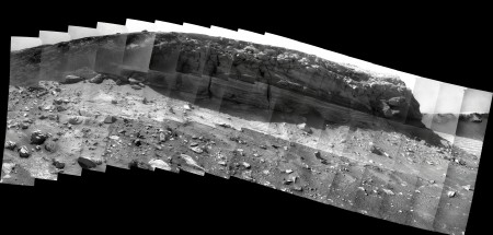
The next step will be coloration
.
jamescanvin
Jul 8 2008, 03:12 PM
QUOTE (Ant103 @ Jul 8 2008, 03:06 PM)
James, you're really fast
What is you secret
?
Many years of writing a stupidly complex program to do a lot of the hard work automatically - oh and what time did I post that pan, half past midnight!
Good luck with your version!
James
TheChemist
Jul 8 2008, 03:19 PM
Many thanks James and Stu !

I don't know about you guys, but for my eyes the 3D images Stu posts happen to be the most realistic ones I've ever seen.
Stu, please keep them coming !
And as a bonus ..... there is a small abyss in the left of the cape :-)
fredk
Jul 8 2008, 05:19 PM
QUOTE (CosmicRocker @ Jul 8 2008, 05:47 AM)
One of the latest tau images from sol 1583 apparently captured a local sunset.
Tman's decoder gives just after 5pm local time for that image (as anyone who's lived in the mountains knows well, apparent sunset can be well before "true" sunset, when the sun hits zero degrees elevation). If that azimuth of 64 degrees is right, I think that point is off the left edge of the new pancam mosaic.
Did you guys notice that the corresponding R8 image to that L8 sunset shot is empty (1x1 pixel)? Apparently the parallax between left and right cameras meant that the sun had already set for the right camera, and so the solar auto-cropping routine just returned an empty image. If you were looking at the rover at the time those images were taken, you'd see the shadow of Verde bisecting pancam, with the right camera in shadow and the left in (partial) sun.
QUOTE (TheChemist @ Jul 8 2008, 04:19 PM)
I don't know about you guys, but for my eyes the 3D images Stu posts happen to be the most realistic ones I've ever seen.
Stu, please keep them coming !
Wow, thanks, I really appreciate that. I just realise that there's No Way I can produce panoramas as good as others here, but I have got quite nifty at making 3D pics and colourised crops, so I limit myself to those now. I love being able to look into a 3D image and imagine reaching into it, through the screen, across all those millions of kilometres, and wrapping my hand around the rock, feeling its rough edges even through the thick material of my spacesuit glove, feeling the weight of it as I lift it off the ground and see the talcum-fine martian dust hissing and trickling off it before holding it up in front of my visor and turning it round and round, wondering and marvelling at how long it's sat there, inside Victoria Crater... it's just the most amazing feeling...
Gonzz
Jul 8 2008, 08:01 PM
Gorgeous work James, thank you very much
It's a beautiful cape, a rocky whale cresting over a waterless sea
Tesheiner
Jul 8 2008, 11:07 PM
TheChemist
Jul 8 2008, 11:45 PM
Fingers crossed. The sand looks very soft
Astro0
Jul 9 2008, 12:16 AM
Take a right and DON'T go into the Light.
Click to view attachment
This is a "lo-fi" version of our main content. To view the full version with more information, formatting and images, please
click here.