Also (as was requested here) they are now sorting images by sol
http://phoenix.lpl.arizona.edu/imageCategories_lander.php
Full Version: Sol 3 and onwards - imaging
QUOTE (Graham @ May 29 2008, 04:39 PM) 
C/5 = (F-32)/9
and I've carried that in my head for over 40 years !
and I've carried that in my head for over 40 years !
I always calculate it out from the equation that one degree C equals 1.8 degrees F.
-the other Doug
We Canadians are bilingual not just in French and English (My wife is French so I speak it as well) but also when it comes to metric and inches and farenheight. Even though we've been metric for 30 years, drive in kilometers, buy a litre of milk and speak in kilos, ask our height and weight, we'll give you feet - inches, and pounds on a scale - every time.
To answer my own question about self portraits wityh the Robotic Arm Camera, I reazized that unfortuntealy the camer is fixed above the wrist, so it really doesn't have a way of turning back from a distance to view the lander. The only way is to fold itself to the point it is just above the deck.
QUOTE (bgarlick @ May 30 2008, 04:22 AM)
Also (as was requested here) they are now sorting images by sol
http://phoenix.lpl.arizona.edu/imageCategories_lander.php
http://phoenix.lpl.arizona.edu/imageCategories_lander.php
Fantastic, really great job. Many congratulations and thanks to the Phoenix team, who are clearly up and running already, very organised, very quick and putting out some really good products too. These posters are excellent and well worth printing out. Take a look at the postcards too, you'll want those on your wall...

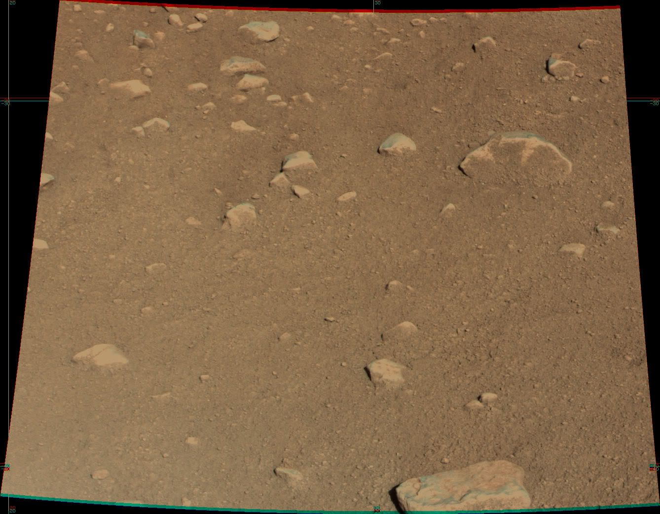
This image from the Optical Microscope (sol 4) shows a waterdrop-like feature. Could that be any frozen liquid?
http://phoenix.lpl.arizona.edu/images.php?gID=921&cID=25
Another odd (spring-like) object in the sand http://phoenix.lpl.arizona.edu/images/gallery/lg_838.jpg
(Oops didn't see the new Microscope thread)
http://phoenix.lpl.arizona.edu/images.php?gID=921&cID=25
Another odd (spring-like) object in the sand http://phoenix.lpl.arizona.edu/images/gallery/lg_838.jpg
(Oops didn't see the new Microscope thread)
Intriguing droplet like object.
Isn't the droplet silicone?
I was fooled by something similar a few years ago with the rovers...
And the fantastic martian greeting dance on the top left?!
EDITED: Stu...you were right...a monster was created...
I was fooled by something similar a few years ago with the rovers...
And the fantastic martian greeting dance on the top left?!
EDITED: Stu...you were right...a monster was created...
Up to now, we are acquainted about the Phoenix position and its orientation. Their solar panels are more or less aligned on the west-east line. The Robotic Arm is at the corner of one of legs which is on the north position along with other legs. The third leg is positioned on the south side.
Now, I still don't know really about what surface can the RA reach?
Now, I still don't know really about what surface can the RA reach?
QUOTE (bgarlick @ May 29 2008, 07:13 PM)
New images arriving.
Is this solid ice exposed by the retro rockets under the lander?
http://phoenix.lpl.arizona.edu/images.php?gID=836&cID=25
Is this solid ice exposed by the retro rockets under the lander?
http://phoenix.lpl.arizona.edu/images.php?gID=836&cID=25
Does anyone else think that we are looking at bedrock ice here exposed by the decent rockets? What else could the large, smooth outcrop be under the lander? (near the top of the image).
It can't be a big rock since no such rock is seen in the pre-landing MRO image and the odds of landing on the only large rock anywhere around are astronomically small.
Isn't this significant? Doesn't this imply digging for ice will be a piece of cake? It looks like there are not a lot of rocks frozen into the ice. It looks smooth and even a bit eroded (see small 'channel').
P.S. I am starting to wonder if many of the smooth cobbles around the lander are actually hunks of dusty ice and not 'rocks' after all. In the press briefing they did make note of how the 'rocks' were lighter in color than the soil and were flat shaped...
QUOTE (bgarlick @ May 30 2008, 05:39 PM)
P.S. I am starting to wonder if many of the smooth cobbles around the lander are actually hunks of dusty ice and not 'rocks' after all. In the press briefing they did make note of how the 'rocks' were lighter in color than the soil and were flat shaped...
Lucky for us pykrete only can be made with porous and fibrous material. That stuff is really tough.
Now that the arm is deployed, did anyone catch the science plan for today, Sol 5 ?
Could someone point me to a thread or link that compares Pheonix's main camera with MER's Pancam?
Thanks in advance!
Kung
Thanks in advance!
Kung
"Does anyone else think that we are looking at bedrock ice here exposed by the decent rockets? What else could the large, smooth outcrop be under the lander?"
A better explanation would be duricrust, a common observation at the older landing sites. Fine-grained regolith (soil) cemented by salts left from the evaporation of water.
Phil
A better explanation would be duricrust, a common observation at the older landing sites. Fine-grained regolith (soil) cemented by salts left from the evaporation of water.
Phil
"WAY more horizon relief than I was expecting."
I thought so to. I talked to Peter Smith at LPSC 2007 about that - just after Green Valley was announced as the site, and said that it looked like we might actually see some relief - the previous sites were even flatter. He warned that the valley was in fact very wide and shallow, so don't expect too much. But I'm very happy to see what we are seeing. I hope taht there will be time during the mission for high quality horizon imaging with a variety of illumination angles, because one view doesn't tell the whole story. Ideally, every point should be viewed up-sun, down-sun and lit from the side. Look at Viking 2 images of the eastern horizon to see what i mean. Totally different with different lighting.
Phil
QUOTE (Sunspot @ May 30 2008, 05:27 PM)
Now that the arm is deployed, did anyone catch the science plan for today, Sol 5 ?
The press conf at 6pm UT will cover it.
Doug
QUOTE (kungpostyle @ May 30 2008, 11:34 AM)
Could someone point me to a thread or link that compares Pheonix's main camera with MER's Pancam?
Thanks in advance!
Kung
Thanks in advance!
Kung
http://www.met.tamu.edu/mars/
click on SSI vital statistics
not sure what this means:
Diopter (filters R6 and R7) best focus at 1.2 m, in focus from 1 to 1.4 m
QUOTE (alan @ May 30 2008, 12:14 PM)
not sure what this means:
Diopter (filters R6 and R7) best focus at 1.2 m, in focus from 1 to 1.4 m
Diopter (filters R6 and R7) best focus at 1.2 m, in focus from 1 to 1.4 m
Cool! Those "filters" are then really lenses for closer-up work, perhaps optimised for taking images of the crucial TEGA and MEVA soil apertures.
Airbag
Either the NASA TV stream is bad today or (much more likely) my in-laws' Internet service is crap, so I had a terrible experience trying to view today's press briefing, and I missed much of the discussion of the planned activities for this sol. Can anyone post a summary here? All I caught was, they are planning on doing some color imaging with RAC of those platy things underneath the lander, to try to figure out if it's duricrust or ice.
--Emily
--Emily
today's briefing..
no intelligent questions..
no intelligent questions..
QUOTE (elakdawalla @ May 30 2008, 08:23 PM)
Either the NASA TV stream is bad today or (much more likely) my in-laws' Internet service is crap
Bad here too....hopefully it'll be on space-multimedia tomorrow.
Could anyone point out a higher resolution version of this
PhilCo126: There's a link near the bottom of this page: http://www.nasa.gov/mission_pages/phoenix/...ol3-v8_001.html
QUOTE (elakdawalla @ May 30 2008, 06:23 PM)
Either the NASA TV stream is bad today or (much more likely) my in-laws' Internet service is crap, so I had a terrible experience trying to view today's press briefing, and I missed much of the discussion of the planned activities for this sol. Can anyone post a summary here? All I caught was, they are planning on doing some color imaging with RAC of those platy things underneath the lander, to try to figure out if it's duricrust or ice.
--Emily
--Emily
Pressconf. may 30:
- Ion source in TEGA seems to be broken (short circuit), fortunately there's 2 filaments, from which one's out of order. They'll do diagnostic work tomorrow to nail down the anomaly. It was stated that the anomaly has no relation with moisture that was found during cruise, which was baked out with a heater that was designed to do just that.
- They were pretty confident that they can use the instrument completely (without losing capabilities)
- They'll take additional images of the "platy things" at sol 6
- The platy things are out of reach w.r.t. the digging arm
- They'll assess which from two areas (didn' tell which ones) of the work space will be chosen to do a touch only, to see some rough soil properties.
- An assessment of spacecraft stability will be done w.r.t. moving the arm (are they afraid it'll topple over ?)
- After that they'll do a digg and dump, dumping very close to the digg to prevent contamination of the soil in between
- After that they'll assess where to go deeper (trenching): they were pretty confident the platy like structures will be within the arms reach under the regolith
- Planning of activities is highly defined by the sol to sol data that comes in, longer time planning (and strategy) has to devellop from knowledge from this tactical phase.
- A profile of the atmosphere in time (and how dust load is distributed over height) was shown by the canadian meteo guy. Dust load increased last sol
- ...?
Marcel.
-
Hey everybody! I have finally got the chance to see the images from Phoenix and i am stunned 
And confused!
And confused!
Thanks very much Marcel. I can add that one of the two digging areas under consideration is Humpty Dumpty, but there is evidently some argument within the team about whether that one or another area is better. One of the two sites is going to be imaged in detail today. Once they decide, in Ray's words, the plan will be "touch, dig, and dump."
--Emily
--Emily
QUOTE (elakdawalla @ May 30 2008, 01:23 PM)
Can anyone post a summary here?
--Emily
--Emily
This isn't really a summary but a few important points.
-------------
LIDAR:
They did about a half-hour of LIDAR and noticed an unmistakable build up of atmospheric dust during the run. A graphic showing the results was presented.
Next Briefing:
NO earlier than next Tuesday.
-------
Hopefully someone else will add to and/or correct me.
Jack
QUOTE (djellison @ May 29 2008, 09:18 PM)
Phoenix - in TallovisioN - WAY more horizon relief than I was expecting.
Well I've been away for a few hours so only just seen this - EXCELLENT!
QUOTE (ngunn @ May 30 2008, 10:37 PM)
Well I've been away for a few hours so only just seen this - EXCELLENT!
What has been presented to the conference is nice too. Have az look at the todays released pictures.
According to Phoenix's twitter, there is something that might be a pin between the leg and the possible ice/rock in the image published earlier.
I haven't found any information about the reach of Robotic Arm from the spacecraft?. Only the RA can work on the north side?
RA is just over 8 feet long. If the deck is about 3 feet above the surface I guess the reach will be about 4 feet.
Upon looking at sol 5 pictures of "sliding rock", I think it should be renamed "rolling rock". Or am I drinking too much Pennsylvania beer?
QUOTE (James Sorenson @ May 31 2008, 02:24 AM)
OMFG Im gonna need that swear jar now .
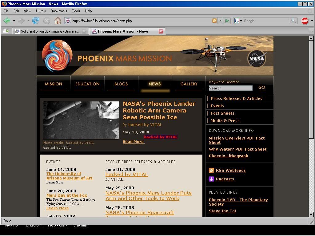
It looks like the phoenix website was hacked.
EDIT: Now its back to normal, it said that it was hacked by vital.
.It looks like the phoenix website was hacked.
EDIT: Now its back to normal, it said that it was hacked by vital.
Still says it here....twice
http://fawkes3.lpl.arizona.edu/news.php
I know, GRRRRRRR  .
.
.
Mars Phoenix on Twitter:
QUOTE
solar panels: yes, they'll get dusty. But friendly dust devils 
have been a huge help to keeping rovers' panels clean. I hope to meet a few! 09:59 PM May 26, 2008 from web
have been a huge help to keeping rovers' panels clean. I hope to meet a few! 09:59 PM May 26, 2008 from web
Even Phoenix is playing with Doug's nerves
I start to think the WE may be right
BTW, I didn't understand the same as Marcel. I think they said that the arm cannot get to the ice like feature.
I start to think the WE may be right
BTW, I didn't understand the same as Marcel. I think they said that the arm cannot get to the ice like feature.
I think this is more work-volume imagery
Some color stuff:


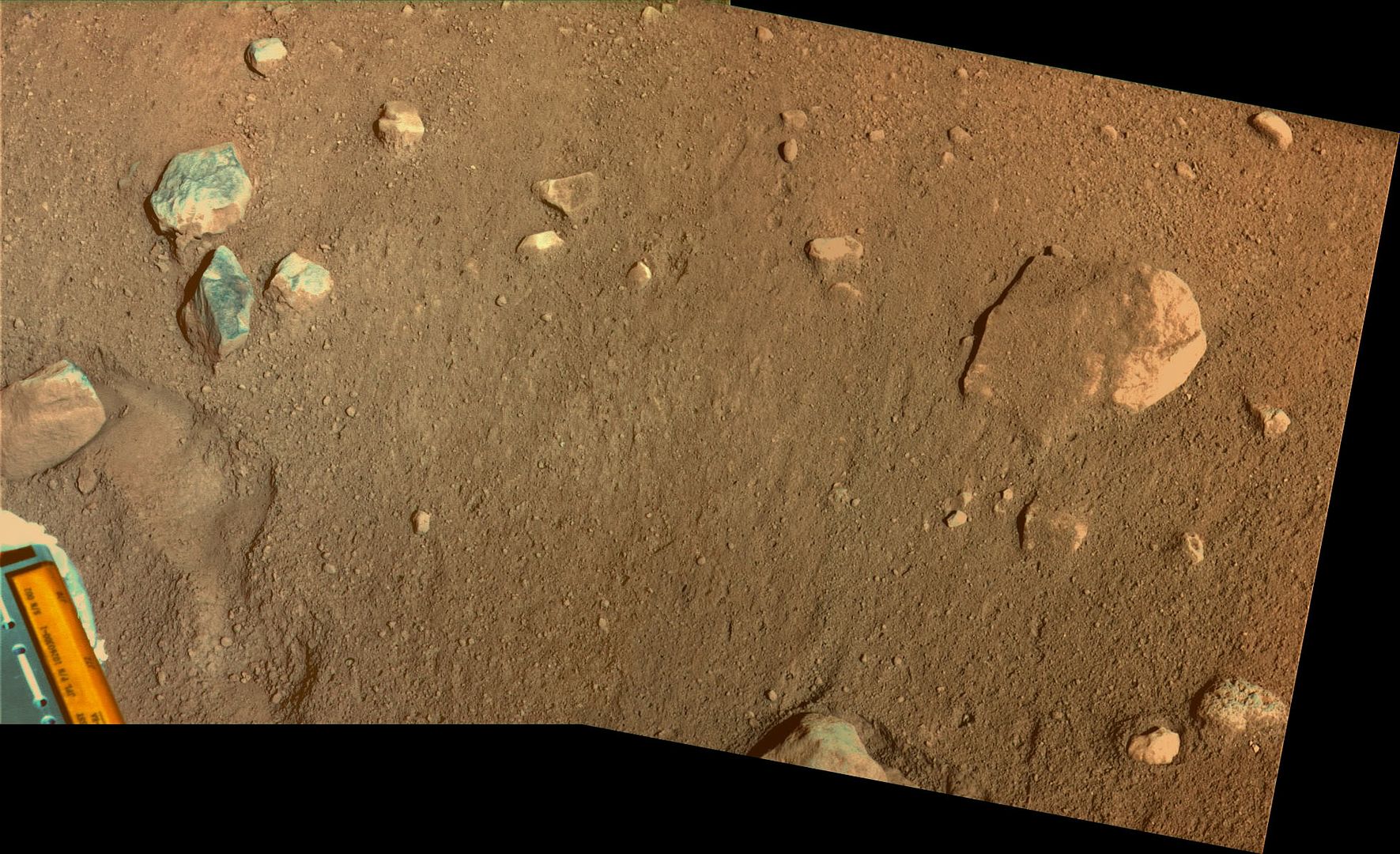
With the benefit of the first look under the vehicle clearly showing that several cms of surface cover have been blown clear by the thrusters, I think the recently emplaced dust is visible where it fell across the work volume - a sort of pseudo ejecta blanket. Here's a crude doodle over Doug's stitch. It looks like the bottom four-fifths of the image, the grayer material, was blasted there. (It's harder to make out on the left-hand image, the colours change at the seam line - a lighting effect presumably.)
I also doodled arrows where the rolling rock appears to have, er, rolled.
Click to view attachment
Those three knobbly blue-green/white-ish "pebbles" just above the roller's path look different from the rocks others, don't they?
I also doodled arrows where the rolling rock appears to have, er, rolled.
Click to view attachment
Those three knobbly blue-green/white-ish "pebbles" just above the roller's path look different from the rocks others, don't they?
So much in Doug's mosaic.
I've added a sample of bouncing stones (green), missing stones (blown away(red)), pushed in stones (blue)and it looks to me like some of the surface of the rock at the bottom of the picture may have been blown off (cyan lines)
Roy
I've added a sample of bouncing stones (green), missing stones (blown away(red)), pushed in stones (blue)and it looks to me like some of the surface of the rock at the bottom of the picture may have been blown off (cyan lines)
Roy
QUOTE (imipak @ May 31 2008, 05:57 AM)
Those three knobbly blue-green/white-ish "pebbles" just above the roller's path look different from the rocks others, don't they?
Yeah, they do. Speaking as an utter ignoramus concerning color composition/gamma/etc., are surface tones exaggerated here? (I know that the "true color" of Mars surface pics are about ten light-years beyond problematic.) Anything greenish-whitish in this area might well be an ice candidate.
I've been having a lot of trouble getting onto the University of Arizona Phoenix website (http://phoenix.lpl.arizona.edu/). Are Phoenix related sites really under denial of service attacks? Who would do that? What would be the point?
QUOTE (kungpostyle @ May 31 2008, 02:12 PM)
I've been having a lot of trouble getting onto the University of Arizona Phoenix website (http://phoenix.lpl.arizona.edu/). Are Phoenix related sites really under denial of service attacks? Who would do that? What would be the point?
The site got hacked last night.
It's probably down for repairs.
Screenshot of hack
Links where hackers name is led to a russian site in his name
QUOTE (kungpostyle @ May 31 2008, 01:12 PM)
I've been having a lot of trouble getting onto the University of Arizona Phoenix website (http://phoenix.lpl.arizona.edu/). Are Phoenix related sites really under denial of service attacks? Who would do that? What would be the point?
The website was hacked last night, but I think the current outage is a voluntary one while they fix the problem.
Well,I hope this guy is proud of himself. I guess we have one advantage over him.
Every morning when we look in the mirror we don't see "Vital" looking back at us.
Every morning when we look in the mirror we don't see "Vital" looking back at us.
QUOTE (kungpostyle @ May 31 2008, 07:35 PM)
Well,I hope this guy is proud of himself.
It doesn't even look like much of a hack - he's managed to add (or modify) a news item, but that's it. No new files uploaded or anything - sounds like he's only managed to access the database. Not exactly 'owning' the server...
'Vital', you're rubbish!
And annoying. Especially as there could be loads of new, interesting raw images appearing around now. Sigh...
Here's my take on the color images. Click to view attachment
Back on the stone issue. The more little stones seams clearly blown away.
Now, what about the big stone large enough,the underneath would touch the ice so it would have slided on the ice. That could be consistent with the long trajectory with respect to its size.
Now, what about the big stone large enough,the underneath would touch the ice so it would have slided on the ice. That could be consistent with the long trajectory with respect to its size.
Pardon all the typos in the below, it's my notes from part of the press briefing, Uwe Keller talking about the image. Will post more later today but wanted you guys to see this before Europe goes to bed
--Emily
QUOTE
It's like you go down and look through your legs, so the image when it came back was upside down. What we see is astounding, because looking south we see illuminated surface of soil, you can see shadow of leg struts on surface, and in foreground you see dark shadowed ground underneath the lander in shadow. A large part of the surface is uncovered by the exhaust of the thrusters. It is tabular, shiny, and smooth, and this is a strong indication that we are looking at the icy table just covered by a few centimeters of soil. The thrusters during the landing uncovered this part. And you can see some down grade from the foot to the center of the image. The purpose of this image was to look at the third leg. If you follow the shadows of the legs, you can see that the shadow is bent, strongly indicating the gradient in the surface, the soil is several centimeters higher than the smooth whitish surface. Clearly indicating that the surface is uncovered by the thrusters. The fact that you see relatively large parts being flat indicates a table of ice. So wherever we will be digging, we will hit ice after uncovering a few centimeters of soil. At top of image you can see three thrusters which were used during the landing.
Peter: We're doing 60 Mb per pass, 2 Odyssey passes per day, twice as much as we were offered. Starting to compress images less and take more filters. Even with non-use of MRO, we're still data rich.
King of Hearts is way to the left, just ot the left of national park line, for next 2 or 3 days we'll be doing digging operations.
We brought down web page to fix problem, but didn't lose anything.
Uwe: try to look for changes. We already repeated observation, but we don't expect to see differences on short interval. The sublimation rate may be a few microns per day. This depends on model you take, whether you add some ice or you lose some ice. It depends on wind velocity
Observation for today, high priority we introduce some additional observations of first leg, where we saw patch we now think is ice. This patch we can get close enough so that we can use color LEDs and can produce an RGB image which means we can produce a color image. We can tell albedo of a particular patch and give us much more confidence in decision whether this is really ice or not.
--Emily
This is a "lo-fi" version of our main content. To view the full version with more information, formatting and images, please click here.