ustrax
Jan 23 2007, 12:01 PM
QUOTE (Tesheiner @ Jan 22 2007, 09:03 AM)

Oppy drove again on sol 1064
Tesheiner, could you point me out where are these?:
"Sol 1062 (Jan. 18, 2007): Opportunity acquired panoramic camera images of a rock outcrop known as "Guam," exposed on the plains above the rim of Victoria Crater.
The camera also photographed cobbles "Gallego," "Vasco" and "Gomes" along the rim. Opportunity acquired miniature thermal emission spectrometer data on Gallego, the soil next to Gallego, and Vasco. Plans called for Opportunity to take snapshots of comet McNaught the next morning."
That was one of the survivors, the
Portuguese Vasco Gomes Gallego.
I REALLY want to see where does a seaman memory lays on Mars...

Tesheiner
Jan 23 2007, 01:16 PM
The images were not yet downlinked, only the tiny thumbnails.
Anyway, it's enough to identify those cobbles on the navcam mosaic for sol 1061. Here you have it.
Click to view attachment
ustrax
Jan 23 2007, 01:58 PM
QUOTE (Tesheiner @ Jan 23 2007, 01:16 PM)

again (see
http://www.unmannedspaceflight.com/index.p...ic=3792&hl=If we once have a real-life UMSF BBQ you buy all beer 
Thanks Tesheiner!
According to Bergreen
this man was Victoria's pilot...
I just love this kind of fusion between History and actual Exploration...

Tesheiner
Jan 23 2007, 04:52 PM
QUOTE (CosmicRocker @ Jan 23 2007, 07:22 AM)
I hope you are right, Tesheiner. If Opportunity does not actually visit the outcrop, I would really like to see some Pancams in its direction at the closest approach. I hate to go out on a limb like this, but that outcrop really looks much like the other ejecta we've seen.
Here you have the answer, Tom.

Fresh images from sol 1066:
http://nasa.exploratorium.edu/mars/opportu...cam/2007-01-23/And a navcam mosaic (3x1). The dock is on the first frame.
Click to view attachment
Floyd
Jan 23 2007, 04:55 PM
Is there a drive issue with Opportunity?
Tesheiner
Jan 23 2007, 05:06 PM
Due to
this driving pattern?
It looks something related to the front wheel steering mechanism which is no longer working.
Or maybe Oppy is a bit drunk and already celebrating its 3rd anniversary.
Marz
Jan 23 2007, 05:06 PM
QUOTE (Floyd @ Jan 23 2007, 10:55 AM)
Is there a drive issue with Opportunity?
Apparently something aborted the sol-1065 before it completed. They'd planned a new course, but strange that they would overshoot the dock, unless they want to start at the top layer and work down?
fredk
Jan 23 2007, 05:38 PM
Perhaps they're heading into the open and safe plains to do some drive software testing?
Or perhaps they're taking an easier route to the Cape C1-2 area, bypassing Cape Desire?
ustrax
Jan 23 2007, 05:45 PM
QUOTE
If we once have a real-life UMSF BBQ you buy all beer
I gladly would...
Tesheiner
Jan 23 2007, 05:57 PM
On another topic, in
this navcam shot we can easily see the famous dark bands at the bays C5 and D2.
djellison
Jan 23 2007, 06:11 PM
It'll be interesting to see if we get a jump in Whr's when we hit those dark streaks - my initial thought is faster winds clearing all but the fine dust leaving just dark basaltic sand + concretions behind.
Doug
jvandriel
Jan 23 2007, 07:40 PM
Added 1 image.
The panoramic view from Sol 1064.
Taken with the L0 Navcam.
jvandriel
jvandriel
Jan 23 2007, 08:10 PM
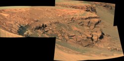
The other side of Victoria crater.
A panoramic view taken on Sol 1064
with the L2 Pancam.
jvandriel
fredk
Jan 24 2007, 03:54 AM
From
Squyres's latest update, the explanation of the curious tracks:
QUOTE
We're now working our way around the Bay of Toil to our next imaging spot at the tip of Cape Desire. Driving here has been difficult. ... we make extensive use of ... visodom. ... Problem is, there are very few features in the terrain here... the soil is so bland that there's almost nothing for the visodom software to "lock on" to. This has created problems for us, and we've had a couple of busted drives as a result.
Our rover drivers, however, are nothing if not creative. If Mars doesn't give us features to look at, they figured, we'll make our own features. So recently, we've done a drive where the rover did a strange little dance as it moved along, scuffing the soil and weaving from side to side, making some of the strangest-looking rover tracks you've ever seen. (One of the maneuvers they came up with they called the "drunken sailor walk".) It looks weird, but it works. We did 40 visodom tests on that drive, and 39 of them worked. So next time you see some strange-looking wheel tracks, it's just the rover scuffing up the terrain so it can figure out where it is.
climber
Jan 24 2007, 06:32 AM
I'm amazed how creative these guys are. Looks evident now when you know it, but well.
Will be nice to see if somebody here could come up with another bright idea to help visodom. Come on guys, be creative!
helvick
Jan 24 2007, 07:23 AM
That is a fantastic bit of creative problem solving, absolutely love it.
They should start "writing" out messages in morse using this drunken sailor track - they could start with:
-- . .-. .-. ..- .-.. . ...
Steve G
Jan 24 2007, 08:08 AM
QUOTE (jvandriel @ Jan 23 2007, 01:10 PM)
The other side of Victoria crater.
A panoramic view taken on Sol 1064
with the L2 Pancam.
jvandriel
I like the minature "Chimney Rock" feature on the far left.
Pertinax
Jan 24 2007, 01:01 PM
or maybe if Oppy is feeling a bit more poetical and ironically spry...
.. / --. .-. --- .-- / --- .-.. -.. / .-.-.- .-.-.- .-.-.- / .. / --. .-. --- .-- / --- .-.. -.. / .-.-.- .-.-.- .-.-.- / .. / ... .... .- .-.. .-.. / .-- . .- .-. / - .... . / -... --- - - --- -- ... / --- ..-. / -- -.-- / - .-. --- ..- ... . .-. ... / .-. --- .-.. .-.. . -.. .-.-.-
-- Pertinax
RobertEB
Jan 24 2007, 01:47 PM
I hope they take a look at Guam (the dock). Might be interesting.
Tesheiner
Jan 24 2007, 04:46 PM
Another "drunky" move on sol 1067:
http://nasa.exploratorium.edu/mars/opportu...PAP1312L0M1.JPGThe dock/Guam can be seen on the rhaz pic too; we just left it behind.

There is a
single downlinked navcam right now but IMO the rover is facing Cape Desire.
RobertEB
Jan 24 2007, 06:19 PM
I am curious if Guam is an uplift feature from the impact that created Victoria, or rock being exposed by material slumping down into the crater. If the latter, that would be one large slump Opportunity is driving on.
Floyd
Jan 24 2007, 06:31 PM
Pancams and additional navcams in at
exploratorium.
climber
Jan 24 2007, 08:19 PM
We're a few meters below the Beacon now :
Click to view attachmentDid you already notice this
"fault" feature ?
Click to view attachment
jvandriel
Jan 24 2007, 09:09 PM
Drunken Sailor track.
The panoramic view from Sol 1066.
Taken with the L0 Navcam.
jvandriel
Phil Stooke
Jan 24 2007, 09:41 PM
The latest drive reminds me of the time I put too much Irish Cream on my cornflakes.
Phil
Pando
Jan 25 2007, 01:36 AM
QUOTE (Pertinax @ Jan 24 2007, 05:01 AM)
or maybe if Oppy is feeling a bit more poetical and ironically spry...
.. / --. .-. --- .-- / --- .-.. -.. / .-.-.- .-.-.- .-.-.- / .. / --. .-. --- .-- / --- .-.. -.. / .-.-.- .-.-.- .-.-.- / .. / ... .... .- .-.. .-.. / .-- . .- .-. / - .... . / -... --- - - --- -- ... / --- ..-. / -- -.-- / - .-. --- ..- ... . .-. ... / .-. --- .-.. .-.. . -.. .-.-.-
-- Pertinax

Tesheiner
Jan 25 2007, 10:03 AM
QUOTE (RobertEB @ Jan 24 2007, 02:47 PM)
I hope they take a look at Guam (the dock). Might be interesting.
It was imaged yestersol (1067) but not yet downlinked.
01067::p2570::17::2::2::0::0::2::6::pancam_guam_LOCO_L7R1QUOTE (climber @ Jan 24 2007, 09:19 PM)
Did you already notice this "fault" feature ?
It can be barely seen on
this pancam part of the Duck Bay panorama.
And on Cape Verde
shots too.
jamescanvin
Jan 29 2007, 03:42 AM
As we move out onto Cape Desire it looks like the focus is on the next bay, Bahia Blanca. Posts from the last few sols moved to a
new thread for this bay.
CosmicRocker
Jan 31 2007, 06:41 AM
Yipee! The
Otis Redding Pancams came down today, and there we were, (Sittin' on) the Dock of the Bay.
I have been praying for these pancams for a while, and I think it's a very nice scene. I was hoping for more, but I'll take an L7R1 pair any day. The Dock seems to be one of the several ejecta layers which has been eroded back. For some time I have been wondering why the ejecta seemed to be layered, but it makes sense that stuff was thrown out of the crater by processes that created overlapping layers.
Anyway, that's what it looks like to me. Here is the anaglyph of the feature otherwise known as Guam.
Click to view attachmentI couldn't help but wonder what the rubble pile in the distance was, so I will also include a HiRise image with my best guess as to where that is.
Our current position at a lower elevation is visible in the background of the anaglyph.Click to view attachment
Tesheiner
Jan 31 2007, 09:31 AM
I was doing my usual early morning (GMT+1) lookup at the exploratorium looking for "fresh" yestersol images of Opportunity and just found old ones. I simply forgot about those missing (and long waiting) "LOCO" images of the dock. Thanks Tom for the reminder.
I agree with your guess for the rubble pile position. About our current position, it's well out of the fov to the right and more on the foreground then at the background. Here are two navcams on that same heading (a much bigger fov, of course!) for reference. I think that the cape visible on the background at a lower elevation on the "loco" pancam is C3.


ngunn
Jan 31 2007, 01:58 PM
I hope somebody does a nice (perspective?) merge of those two navcam shots. I've just had a go with scissors and sticky tape and the result is a highly satisfying landscape composition. The whole scene is very clearly laid out before the eye all the way from Dock to Soup Dragon. The downcurving profile of the apron off to the left is striking too.
Tesheiner
Jan 31 2007, 02:31 PM
You have not only two but five navcams in Jvandriel's mosaic (post #124 above).
CosmicRocker
Jan 31 2007, 03:21 PM
Yes, Tesheiner...C3. I jumped to a conclusion when I saw that pointed cape, even though the current location couldn't possiblly be along that line of site.
ngunn
Jan 31 2007, 03:49 PM
So we do!!!!! Thanks. However for some reason the relevant part of that looks a lot less compelling that what I've just printed off and stuck together. I don't know if its the scale, the contrast or what. In case anybody wants to try it here is the very simple recipe:
I printed the 2 images in your post on A4 in landscape format, which had the effect of cropping off the bottom third of each. I then trimmed off only the right white margin of the left hand image and stuck them together to give a straight horizon with the middle distance matched as well as possible. The result is a picture, 47cm by17cm with ready-made white margin, which is going on my wall!
jamescanvin
Feb 5 2007, 12:42 PM
Other versions were posted in the Bahia Blanca thread but this really belongs here.
My version of the stunning 5pm view from Cabo Anonimo.

I can't wait for one of you colouring in folks to attack this view.

James.
And that brings up the big 1000 posts. Still, can't keep up with Spirit or Oppy sols though.
ustrax
Feb 5 2007, 01:40 PM
QUOTE (jamescanvin @ Feb 5 2007, 12:42 PM)
My version of the stunning 5pm view from Cabo Anonimo.
Stunning is truly the word!

This is the vista that for me provided the best sense of Victoria's dimensions!
Thanks James!
Nirgal
Feb 5 2007, 02:33 PM
QUOTE (jamescanvin @ Feb 5 2007, 01:42 PM)
Other versions were posted in the Bahia Blanca thread but this really belongs here.
My version of the stunning 5pm view from Cabo Anonimo.
James.
OMG
Seems that I'm missing quite a bit here
How often have I said "this must be the greatest of Oppy's image yet" ... but this one is now definitiely
my NUMBER ONE most fascinating view taken by the Opportunity Rover, if not from the surface of mars at all to date (perhaps only rivaled by Spirit's famous "multi-dust-devil movie")
I especially like the late-afternoon-shadows and the bizarre overall look of the scenery, even with rover tracks to add that sense of scale ... WOW again...
Can't wait to try a colorization at this one
Tesheiner
Feb 5 2007, 02:34 PM
QUOTE (jamescanvin @ Feb 5 2007, 01:42 PM)
And that brings up the big 1000 posts. Still, can't keep up with Spirit or Oppy sols though.
Welcome to the "Part of the furniture" group, James.
Ooops, that's only for the 5000+ posts.
Floyd
Feb 5 2007, 04:57 PM
James, that is a fantastic image. In looking at the dark material, it doesn't look like it could possibly be due to wind action removing a lighter cover--it almost looks as if the darker material is leaking out of the rocks above. For example, see the Soup Dragon, or Cape E1-E2. Anyone want to speculate on this?
Thanks,
Floyd
ngunn
Feb 5 2007, 05:12 PM
QUOTE (Floyd @ Feb 5 2007, 04:57 PM)
it almost looks as if the darker material is leaking out of the rocks above.
Floyd
I agree, that is how it looks. Wasn't there once mention of a possible igneous dike somewhere around here?
Tesheiner
Feb 5 2007, 05:31 PM
My take is for a similar mechanism as the one maintaining El Dorado.
SteveM
Feb 5 2007, 08:46 PM
James
The rover tracks, on both the near and far side of the Bay of Toil, really give a sense of perspective -- and of having been there. Nicely done.
Steve
jamescanvin
Feb 6 2007, 03:47 AM
Thanks all.
The Cape Desire images from Cabo Anonimo have now been downlinked.

James
Ant103
Feb 6 2007, 04:48 PM
Superb James
My own version
The images are too deform by Autostitch sadly
fredk
Feb 8 2007, 07:08 PM
Here's a long-baseline anaglyph of the tip of Cape Desire and Hoy behind it from across the Bay of Toil. Pancam L2 and R2. Taken sols 1060 and 1061, but before the drives both sols, so positions are marked 1058 and 1060 on the route map:
Click to view attachment
fredk
Feb 8 2007, 10:42 PM
Here's the adjoining view just below the previous one. Stunning wind-sculpted hunks of rock.
Click to view attachment
This is a "lo-fi" version of our main content. To view the full version with more information, formatting and images, please
click here.

