tedstryk
May 31 2006, 05:59 PM
QUOTE (DonPMitchell @ May 31 2006, 05:50 PM)

I'm very skeptical about the Mars-3 lander "image". Soviet scientists believe it is just noise, not an image of Mars at all. I should try to get the original data, because we are seeing some random image shown on a television program, which might not even be the Mars-3 signal (I love The Planets, but they often did not show you want they were talking about, when it came to Soviet footage).
I will stress that my best-looking image, as I say on my site, is a "What if" image - it is speculative overprocessing to the max. I would LOVE to locate the original transmission. First, to see if the nature of this fragment can be resoved once and for all, and second, to see if modern techniques can pull out the signal from farther in. I believe that at the one or two minute mark, it would have transmitted the first science data (temperature, pressure, etc.) That would be wonderful to have. Probably a pipe dream though.
AlexBlackwell
May 31 2006, 06:05 PM
QUOTE (tedstryk @ May 29 2006, 04:23 PM)
I have worked a bit more on the image looking down on Phobos over Mars.
I really like how you've enhanced this particular image, Ted. Nice work. As usual

ustrax
May 31 2006, 06:33 PM
QUOTE (tedstryk @ May 31 2006, 06:59 PM)
I will stress that my best-looking image, as I say on my site, is a "What if" image - it is speculative overprocessing to the max. I would LOVE to locate the original transmission. First, to see if the nature of this fragment can be resoved once and for all, and second, to see if modern techniques can pull out the signal from farther in. I believe that at the one or two minute mark, it would have transmitted the first science data (temperature, pressure, etc.) That would be wonderful to have. Probably a pipe dream though.
I didn't realize that the site was yours tedstryk...

QUOTE (djellison @ May 31 2006, 06:35 PM)
See above

That's Ted's work...
Yes, I've been following the amazing work in here but haven't seen anything on the lander data so far...
tedstryk
May 31 2006, 06:35 PM
I basically binned the pixel, reduce speckling at certain levels, and got rid of darkening around the edges. I have an image on my site in which I removed any extreme deviations -

I merged that with an version that allowed the most dark and light areas to stay, so long as they were of sufficient length and width.
I am working from memory here though...I lost my notes on what I did step-by-step in my computer crash.
4th rock from the sun
May 31 2006, 10:26 PM
Playing with the Mars 5 dataset

The 3 color mosaics, with partial color filter data used (just red/green or green/blue) for maximum coverage.
Click to view attachment I'm also doing some mosaics, and there's a good overlap of the images, but the original data has nasty brightness gradients that are dificult to remove.

Interesting the fact that the early Mars probes didn't make a good global coverage of the planet at moderate resolutions...
tedstryk
Jun 1 2006, 12:18 PM
Well, early is relative here....Mariner-9 had already provided more complete coverage. With Mariners 6, 7 and of course 4, it was a bandwith/data storage issue. Great work with Mars-5. I would suggest you increase the hue saturation a bit though.
My results are on my page, although I haven't update in a while. The version on the top is my data merged with a soviet version of the color.
http://pages.preferred.com/%7Etedstryk/mars6.htmlOn another topic, let me also say that this is the Mars-3 version that my earlier description of processing described. The color version is from the same version, but has been hacked at considerably - in other words, I did things like smoothing the sky without the ground. Here is how it looked before such alterations. The bright spots near the "horizon" are processing artifacts, and can be seen to "echo" from the dark spots.

DonPMitchell
Jun 1 2006, 03:20 PM
First, it is important to note that the Mars-3 camera scanned vertically. It was essentially the same camera system as Luna-13, a panoramic scanner with a 360-degree view, consisting of a reciprocating mirror and a photomulitplier tube. So all of these images of the transmission should be rotated 90 degrees.
Click to view attachment Click to view attachment(left) Luna-9 Camera, (right) Mars-3 Camera
The BBC's program,
The Planets showed this image allegedly from Mars-3. That's a great documentary, but it frequencly misidentified Russian images. I have never seen this picture in any Russian film (and I've seen pretty much all of their documentaries on planetary missions). The claim that this is the horizon of Mars was made by the journalists at the BBC, but it is not what the Soviets have ever said. They claim that the transmission from Mars-3 contains no image features.
Click to view attachmentHere is a more reliable view of the Mars-3 signal, being plotted on paper. This is from a Soviet documentary about the M-71 mission. It is not a color transmission from Mars, that just happens to be the ink color.
Click to view attachmentIn the upper portion, notice the vertical stripes on the left and right sides of the plotted picture. These are the sync signals from the camera. At the bottom is a section of what appears to be just random static, no sync signals. The BBC image might be another view of that random static that preceded the "image" data from the camera.
tedstryk
Jun 1 2006, 03:45 PM
It is hard to tell... I wish someone could get ahold of the original transmissions (mainly because I want the Orbiter images, which I know were made, but also to resolve what happened to the lander).
ustrax
Jun 1 2006, 04:31 PM
tedstryk
Jun 8 2006, 01:08 AM
Here is a little pan I have always found cool. Yogi, from behind the rock garden. It really shows how long the rock actually is. Pathfinder looked at it from an angle that made it look much smaller.

ljk4-1
Jun 8 2006, 01:40 AM
QUOTE (DonPMitchell @ Jun 1 2006, 11:20 AM)
Here is a more reliable view of the Mars-3 signal, being plotted on paper. This is from a Soviet documentary about the M-71 mission. It is not a color transmission from Mars, that just happens to be the ink color.
Click to view attachmentIn the upper portion, notice the vertical stripes on the left and right sides of the plotted picture. These are the sync signals from the camera. At the bottom is a section of what appears to be just random static, no sync signals. The BBC image might be another view of that random static that preceded the "image" data from the camera.
This image reminds me of this one:
http://grin.hq.nasa.gov/ABSTRACTS/GPN-2003-00060.html
DonPMitchell
Jun 8 2006, 01:51 AM
QUOTE (ljk4-1 @ Jun 7 2006, 06:40 PM)
Looks like they're both using the same cheap third-party ink-jet cartridges. :-)
gndonald
Jun 8 2006, 04:01 PM
Looking at the Planetary Society website, it seems that the Pioneer Anomaly group has not just managed to track down the trajectory data for Pioneer 10 & 11 but also their science data as well.
It may just be that the raw imagery data from the missions may become available in the near future.
See
the Planetary weblog.
Graham
BruceMoomaw
Jun 9 2006, 01:15 AM
I'm very suspicious about that supposed Mars-3 lander image, too -- because of what the Soviets said at the time, which was that it contained "no discernible differences in contrast" but that it did indicate an "ambient light level" of (if I remember correctly) 25%. Now, they may have been referring to just the part of the image that showed the Martian surface -- but, if it had even shown the horizon, wouldn't the Soviets, always frantic for any propaganda edge no matter how small, at least have mentioned that?
Phil Stooke
Jun 9 2006, 01:28 AM
Bruce is right. Absolutely anything, however useless, if it could have been hailed as the first image from the surface of Mars, it would have been. And why not?
And replying to the point above, from gndonald, I didn't think that report implied raw image data. I thought it was just referring to engineering-type data on spacecraft temperature etc. It would be nice to be wrong.
Phil
DonPMitchell
Jun 9 2006, 02:47 AM
QUOTE (BruceMoomaw @ Jun 8 2006, 06:15 PM)
I'm very suspicious about that supposed Mars-3 lander image, too -- because of what the Soviets said at the time, which was that it contained "no discernible differences in contrast" but that it did indicate an "ambient light level" of (if I remember correctly) 25%. Now, they may have been referring to just the part of the image that showed the Martian surface -- but, if it had even shown the horizon, wouldn't the Soviets, always frantic for any propaganda edge no matter how small, at least have mentioned that?
It would be nice to see Mars-3 raw data, but I agree with Bruce, the Soviet experts say there was nothing, and I'm sure they looked hard.
The Mars-6 lander returned the first
in situ measurements of the atmosphere of Mars during its descent, but contact was lost at the moment of landing. They can make some small claim, but by the mid 1970s, America's planetary probe technology was far ahead of theirs in most respects. The Mars-3 lander was basically early 1960s technology, not vastly different from the original Luna-4 design, while Viking in 1975 was a contemporary engineering marvel.
On Mars-6, a failure in its communication system meant that commands could no be sent from Earth during the last five months of its flight. It's computer sighted Mars, corrected its trajectory midcourse, and ejected the landing capsule successfully, all automatically. I always thought that was kind of impressive.
tedstryk
Jun 17 2006, 08:21 PM
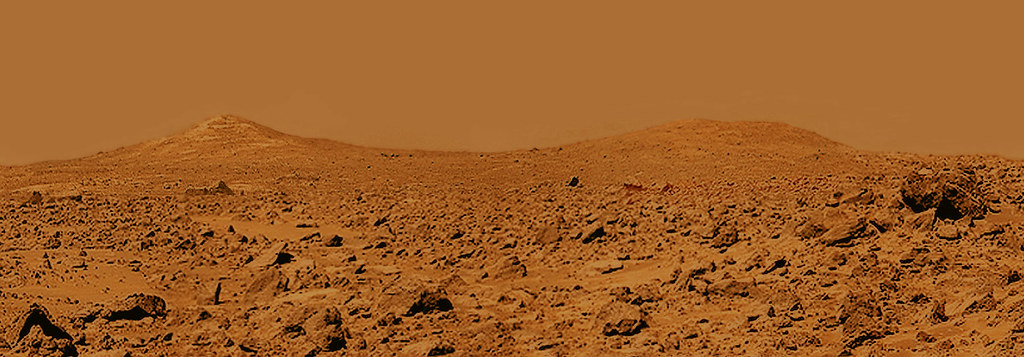
Here is a goodie I found in the Pathfinder archive. It is a very narrow section, and I used some of my mosaic I pasted earlier in this thread to widen it a bit. For reference, the lower image is the same area from the Planetary Photojournal super-resolution view. I just wish the pathfinder products were better organized - it can be really hard to find various sets.

Here is the context on the right peak.

tedstryk
Sep 14 2006, 02:06 PM
As many of you know, my website is gone, and I have not had time to rebuild. Until I can, I am loading some of my images
here.This is my favorite new image I posted.
aldo12xu
Sep 16 2006, 05:08 PM
Sorry to hear about your site, Ted. I'm glad you're uploading your images to Flicker, as your work is extremely good, unique and important. Thanks for the great images and keep 'em coming!
dvandorn
Sep 16 2006, 05:27 PM
And I'll tell you, I *still* want to get over to those Twin Peaks and take a look at the big boulders that lie in the hollow between them.
That raises an interesting question. The rationale for the selection of both the Ares Valles and Chryse Planitia landing sites (MPF and Viking 1, respectively) was that each seems to lie in the midst of an ancient catastrophic outflow channel. The reasoning, as I understood it, was that these sites ought to 1) show signs of the water that once flowed there, and 2) have a lot of rocks on the surface that were transported there by the floods which created the outflow channels.
As far as I know, no significant insights about the former presence of water has ever come from either site -- certainly nothing like what we've seen at both Meridiani and Gusev. Seems those forces left far more subtle clues in the outflow channels than in places where water once pooled and groundwater rose to the surface. So, reasoning path number one seems to have been a bust.
And as for reasoning path number two -- yes, it's interesting to see a large variety of rocks. But they might have come from anywhere along the path of the ancient floods. Doesn't that really muddy the waters (so to speak) when it comes to geologic analysis? Without a context for where these rocks might have formed, don't we get a far-less-helpful set of results, in geological terms, than we would if we were exploring an area in which the surface rocks could mostly be traced back to processes that occurred in the local area?
-the other Doug
tty
Sep 16 2006, 06:18 PM
QUOTE (tedstryk @ Sep 14 2006, 04:06 PM)
As many of you know, my website is gone, and I have not had time to rebuild.
What was the URL? It may still be around at archive.org.
tty
DonPMitchell
Sep 16 2006, 06:50 PM
QUOTE (tedstryk @ Sep 14 2006, 07:06 AM)
As many of you know, my website is gone, and I have not had time to rebuild. Until I can, I am loading some of my images
here.This is my favorite new image I posted.
I'm sorry to hear about your website. I'm a huge fan of media3.net, if you are looking for a reliable host who have been in business for a long time. They offer Windows, BSD and Linux hosting starting at about $8/month.
Beautiful image!
algorimancer
Sep 16 2006, 07:06 PM
QUOTE (dvandorn @ Sep 16 2006, 12:27 PM)
...
As far as I know, no significant insights about the former presence of water has ever come from either site -- certainly nothing like what we've seen at both Meridiani and Gusev. Seems those forces left far more subtle clues in the outflow channels than in places where water once pooled and groundwater rose to the surface. So, reasoning path number one seems to have been a bust.
...
As I recall, Pathfinder did indeed see evidence of a massive flood event, evident in the alignments of the rocks and large scale ripple effects in the surrounding terrain, similar to some of the really big floods they've had in Iceland. The notion of the rocks being out of context is a valid perspective, however, and I agree that at this point it seems wisest to head for places where the rocks can be studied in the context where they formed. Personally I'd like to drop a rover into Hellas crater, which I gather is the lowest point on Mars and the only place where the atmospheric pressure is high enough to allow liquid water to exist. The orbittal pics do look pretty boring though, perhaps what you'd expect of a sea bottom, with the only flow features being near the rim. Perhaps a target for a future rover, I think that there are more interesting places to sent MSL.
Phil Stooke
Sep 16 2006, 09:11 PM
dvandorn's question about Viking 1 and Pathfinder site selection raises interesting points. I'm paying a lot of attention to this now as I begin collectimg material for a future Mars atlas.
Viking 1... it was NOT sent to its landing site because it might show evidence of water flow. That was one point in favour of the Chryse site first chosen for Viking 1, but the very first orbit of certification images revealed erosional 'scablands' and similar terrain, nothing like the smooth surface expected from Mariner 9 images. The Viking site actually used was chosen because, after that scare, they wanted something very smooth, and imaging plus earth-based radar indicated that new site was fairly smooth. In addition, because it looked like a lunar mare, with small craters and wrinkle ridges, they THOUGHT they understood its origins well enough to predict what the rock population would be. Therefore the actual Viking 1 site was basically chosen because it looked like a lunar mare. There was a minor bonus, the Maja Valles floods might have wetted it a bit, though the site was beyond any geomorphological evidence for flow.
Pathfinder was different. Here they went right back to the first Viking site... they key science instrument was APXS on the little rover. The best results would be had if, within the 10 - 20 m expected range of the rover, they could use APXS on rocks with different compositions. So they deliberately chose a "grab-bag" site which might put different rock types (deposited by the floods) within range of Sojouner. Land on bedrock, do one APXS, and you have nothing else to do. Here they might make multiple non-redundant measurements.
Both sites delivered what was expected within reason, though they hoped for more variation in APXS results. The so-called evidence for flow at Pathfinder - imbricated boulders etc., is very weak. Almost every rock at the site is likely to be from local crater ejecta, not the original flow. It might be originall flow-deposited, but it's been reworked and redeposited by impact.
Phil
tedstryk
Sep 17 2006, 03:55 AM
QUOTE (DonPMitchell @ Sep 16 2006, 06:50 PM)
I'm sorry to hear about your website. I'm a huge fan of media3.net, if you are looking for a reliable host who have been in business for a long time. They offer Windows, BSD and Linux hosting starting at about $8/month.
Beautiful image!
I have a new host...the problem is that I haven't had time to set anything up.
tedstryk
Dec 30 2006, 10:37 PM
I have been working with some of the Mariner-6/Mariner-7 images lately. The data is much poorer quality than I imagined - I always assumed that since Mariner 4 and Mariner 9 sent digital data, Mariner 6 and 7 did too. However, a shocking amount if the image data is analog.
Here is a mosaic I constructed using the south polar data. I do think that since the dataset does provide the earliest global mapping at resolution better than a few hundred km, as well as a closeup of the south polar region, the dataset will always have value in our baseline.
Here is the same view at full resolution, but this required much heavier jpeging.

Phil Stooke
Dec 31 2006, 02:08 AM
Very nice, Ted. Happy New Year!
Phil
mcaplinger
Dec 31 2006, 04:28 AM
QUOTE (tedstryk @ Dec 30 2006, 02:37 PM)
I have been working with some of the Mariner-6/Mariner-7 images lately. The data is much poorer quality than I imagined - I always assumed that since Mariner 4 and Mariner 9 sent digital data, Mariner 6 and 7 did too. However, a shocking amount if the image data is analog.
You might be interested to read my summary of how the MM69 camera system worked:
http://mars.jpl.nasa.gov/mgs/msss/camera/i...m7_imaging.html
tedstryk
Dec 31 2006, 01:53 PM
QUOTE (mcaplinger @ Dec 31 2006, 04:28 AM)
You might be interested to read my summary of how the MM69 camera system worked:
http://mars.jpl.nasa.gov/mgs/msss/camera/i...m7_imaging.htmlThanks. It really is amazing to see how far things have come!
mcaplinger
Dec 31 2006, 07:56 PM
QUOTE (tedstryk @ Dec 30 2006, 02:37 PM)
I have been working with some of the Mariner-6/Mariner-7 images lately.
Which reminds me: does anyone have access to this globe?
http://libweb5.princeton.edu/visual_materi...s/hmc05.html#g7It was drawn using Mariner 6/7 images and (I suspect) a good deal of imagination. I'd love to get a good set of photos of the entire surface.
Bob Shaw
Dec 31 2006, 09:45 PM
QUOTE (mcaplinger @ Dec 31 2006, 07:56 PM)
Which reminds me: does anyone have access to this globe?
http://libweb5.princeton.edu/visual_materi...s/hmc05.html#g7It was drawn using Mariner 6/7 images and (I suspect) a good deal of imagination. I'd love to get a good set of photos of the entire surface.
Mike:
Phil Stooke and I both have that globe, but mine is not on the natty little stand shown in your link (I don't know about Phil's) but on an unattractive grey plastic thing similar to the mounting for an Armillary Sphere.
You're quite correct - it owes much to imagination, but also to the the long-distance far encounter shots taken by Mariner 6 and 7 in 1969. If you look at those images you can clearly see the albedo changes associated with Valles Marineris, with the 'W' of Noctis Labyrinthus being quite clear, and this is reflected on the globe. The interpretation of 'Nix Olympica' as a huge double crater was quite wrong, but again based on albedo - the supposed outer rampart is clearly the offset aureole around Olympus Mons itself. Look sideways and you can almost identify the other three great Tharsis volcanoes too. The globe is fascinationg because it captures a moment in time in the exploration of Mars before the gross facts of the planet were fully captured.
Some areas are slightly more detailed, such as the swathe of features imaged by Mariner 7 around the South Pole, and Mariner 6's observations of (I think) Deucalion.
I'll try to take some photos of my globe at some point and will send them to you if you like. This globe sometimes turns up on eBay, often poorly identified, so obtaining one yourself is not an impossible task!
Bob Shaw
nprev
Dec 31 2006, 10:22 PM
Thanks for posting that link, mcaplinger...neat stuff!
Possibly OT here, but does anyone know if the naming of albedo features vs. actual topographical features on Mars has been reconciled by the IAU? It doesn't look like a lot of the traditional names (e.g., Xanthe, Solis Lacus) are still used by modern cartographers.
tedstryk
Dec 31 2006, 11:45 PM
QUOTE (nprev @ Dec 31 2006, 10:22 PM)
Thanks for posting that link, mcaplinger...neat stuff!
Possibly OT here, but does anyone know if the naming of albedo features vs. actual topographical features on Mars has been reconciled by the IAU? It doesn't look like a lot of the traditional names (e.g., Xanthe, Solis Lacus) are still used by modern cartographers.
There has definitely been an attempt - for example, Sinus Meridiani, the fork-like albedo feature, became Meridiani planum. That globe does look somewhat fictionalized -either that or it is sloppy.
Incidentally, Mariner 4 was also supposed to get the south pole, but missed, although it did catch some frost. Finding out that it was off its intended groundtrack explained a lot, since I wondered why pictures 20-22 were shot off the limb (As for the lack of detail in pictures 17-19, that had to do with a design-flaw related light leak that could be compensated for through stretching in the earlier images, but, given the 6-bit encoding, nearly completely overwhelmed the last frames taken over the shadowy zone near the terminator.

tim53
Jan 4 2007, 12:25 AM
QUOTE (Bob Shaw @ Dec 31 2006, 01:45 PM)
Mike:
Phil Stooke and I both have that globe, but mine is not on the natty little stand shown in your link (I don't know about Phil's) but on an unattractive grey plastic thing similar to the mounting for an Armillary Sphere.
You're quite correct - it owes much to imagination, but also to the the long-distance far encounter shots taken by Mariner 6 and 7 in 1969. If you look at those images you can clearly see the albedo changes associated with Valles Marineris, with the 'W' of Noctis Labyrinthus being quite clear, and this is reflected on the globe. The interpretation of 'Nix Olympica' as a huge double crater was quite wrong, but again based on albedo - the supposed outer rampart is clearly the offset aureole around Olympus Mons itself. Look sideways and you can almost identify the other three great Tharsis volcanoes too. The globe is fascinationg because it captures a moment in time in the exploration of Mars before the gross facts of the planet were fully captured.
Some areas are slightly more detailed, such as the swathe of features imaged by Mariner 7 around the South Pole, and Mariner 6's observations of (I think) Deucalion.
I'll try to take some photos of my globe at some point and will send them to you if you like. This globe sometimes turns up on eBay, often poorly identified, so obtaining one yourself is not an impossible task!
Bob Shaw
I also have a copy of this globe, with the stand. It was in mint condition until several years ago when it got knocked off the bookshelf it was sitting on. Now it's got a dent (I suppose I should see if it could be repaired without damaging it more).
My wife found it at one of those car wash gift shops about 20 years ago!
-Tim.
edstrick
Jan 4 2007, 12:39 PM
The Mariner 4 camera was designed to adjust exposure based on previous image data, but the design was conservative so exposures wouldn't vary widely. It used only <I think> green filter exposures for checking output data levels (images were red/green/red/green, with every 3'rd image not recorded), and if data values were out of range, it would increment one exposure change per green frame cycle. So as they approached the terminator, exposures increased (also increasing light fog from the camera design error), but not fast enough to compensate for dropping light levels.
The Mariner 69 cameras dumped data to twin Mariner 64 tape recorders, one recording analog data, the other recording bit-clipped versions of every 7'th pixels in digital form (more complicated than that, but...). The tape flaked and shed inflight and gummed up the recorder heads a bit, causing high streaky noise levels, equivalent to that on a VHS tape recorded with dirty tape heads. The image reconstruction postflight was a nightmare, but they got much more total pixels than Mariner 4 times two.
Mariner 71 had a new tape design that could hold some 33 fully digital images of (approx) 600 x 800 pixels. The same recorder was used on Mariner Venus/Mercury 73, but new telecommunications ability let them transmit most data in real time.
tedstryk
Jan 16 2007, 04:11 AM
I have added a
Mars 3 Orbiter page to my new site.
Ted
tty
Jan 16 2007, 07:54 PM
A small quibble about one of images, shouldn't "Impygia" be "Iapygia"?
tty
tedstryk
Jan 16 2007, 09:52 PM
QUOTE (tty @ Jan 16 2007, 07:54 PM)
A small quibble about one of images, shouldn't "Impygia" be "Iapygia"?
tty
I transcribed it from a translation of a Russian document, and it had it as "Impygia." Good catch!
tedstryk
Jan 16 2007, 10:57 PM
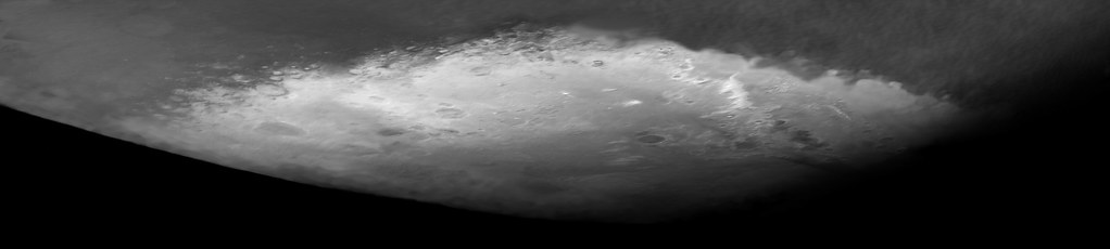
The image I am happiest with is the February 28 crescent. The original image looked like this:

And, after much work, I got this:

This is the only image that I have seen from the mission with underlying data good enough to make a somewhat pretty picture. The December image isn't that bad, but seems to be washed out in some filters.
Stu
Jan 16 2007, 11:13 PM
A crescent Mars... that's one of the most beautiful images you've given us, thank you.
helvick
Jan 16 2007, 11:27 PM
Ted,
I'm going to have to stop being so cynical about those image processing guru's on CSI\24\Alias - how on earth did you manage to pull such an astonishingly beautiful shot out of so much crud and noise?
Sweet!
djellison
Jan 16 2007, 11:47 PM
He pressed zoom 3 times, and 'enhance' twice. Works every time.
tedstryk
Jan 17 2007, 12:45 AM
http://www.strykfoto.org/mars3.htmIn case you missed my earlier post, this link has more of my images from Mars-3. The Soviets published response curves for the RGB filters, and wrote extensive papers on photometric studies of the Mars-3 images. The February 28 set is the only one that they published crude isophot maps for all 3 filters. Whle the resolution is awful on these, it provided a "ground truth" of sorts to remove noise from the images. Also sampling various areas of the disk and correcting for the actual image variations to subtract the scanning streaks helped.
remcook
Jan 17 2007, 09:11 AM
QUOTE (djellison @ Jan 16 2007, 11:47 PM)
He pressed zoom 3 times, and 'enhance' twice. Works every time.
LOL with some more clicks he will certainly be able to read Spirit's numberplate (timing issues aside). Or some reflection on the solar panel.
edstrick
Jan 17 2007, 09:28 AM
"A crescent Mars... that's one of the most beautiful images you've given us, thank you."
Viking Orbiter 2 got a series of nice crescent views on approach to Mars. One has a nice plume-cloud trailing downwind from Olympus or one of the 3 Tharsis big'uns: Curly, Larry, or Moe.
tedstryk
Jan 17 2007, 10:45 AM
QUOTE (edstrick @ Jan 17 2007, 09:28 AM)
"A crescent Mars... that's one of the most beautiful images you've given us, thank you."
Viking Orbiter 2 got a series of nice crescent views on approach to Mars. One has a nice plume-cloud trailing downwind from Olympus or one of the 3 Tharsis big'uns: Curly, Larry, or Moe.
I have actually been playing around with those. I haven't quite figured out Viking color yet, which is why I haven't done anything with them. But, if we are talking about the same series, it is a somewhat lower phase angle.
edstrick
Jan 18 2007, 11:29 AM
The Viking 1 approach image set (approx 90 deg phase) was incomplete and some data may have been lost. It wasn't complete and maybe not available around 1979 when the "Mars Consortium" was perparing simple-cylindrical map projected global Mars datasets for cross correlation. Also, some image data was significantly overexposed.
The Viking 2 data was better but at higher phase angle, not quite as large as the 2 Mars 3 images. Exposures were good. The calibration files used when they were processed for the Mars Consortium had bad shading corrections and put significant color blotches in some of the data.
Viking orbiter color filters were violet, blue, green, orange <called "red"> minus blue <=yellow> and clear. The vidicon tubes' long wave response went to zero in the middle of what the human eyeball calls "red", resulting in an effective "orange" filter response, with a very large overlap with the passband of the green filter. Violet and green had near zero overlap. Usually, color sequences included orange, green and violet frames (or I think orange, green, clear, and violet). Because of filter wheel step-sequencing, blue was rarely used. The green band can be closely approximated by some weighted average of like 70% orange and 30% violet or 80/20. It contains very little independent color information because of a combination of low color contrast between green and the flanking wavelengths, bad overlap with the orange band, and the 7 bit digitization of the Viking images. If you wanted to make a more true color approximation to "natural" color with VO images, other than adjusting the color balance to darken "green" relative to "orange", you could subtract some green from the orange band to give a more "red" weighted response, then boost the "reddend" band's signal to an appropriate value.
tedstryk
Jan 18 2007, 12:55 PM
Thanks edstrick. That really helps. I couldn't for the life of me figure out what the filters actual response was. The references to the orange filter as "red" really confused me (even with Voyager, the documentation calls orange "orange").
Ted
tedstryk
Jan 19 2007, 03:07 AM
Quoting in her blog Emily Lakdawalla "Ted apparently has a masochistic streak. He seems to delight in working with some of the most ornery data sets. "
Never really thought of it that way, but probably true
edstrick
Jan 19 2007, 09:24 AM
"...I couldn't for the life of me figure out what the filters actual response was. ..."
There is a quasi-published (it was paperbound, at least) Viking Orbiter Camera calibration and information guide. I have a copy somewhere, but digging into the "stacks" with my present overload is more than I can plan at the moment. I'll try to find it maybe this weekend and at least get a title for it.
This is a "lo-fi" version of our main content. To view the full version with more information, formatting and images, please
click here.
