Full Version: Zhurong Lander/Rover
Is Zhurong using the rocker-bogie system from MER? Is that patent expired?
It is using a vastly improved version of that system. The wheels can all turn 90 degrees so they can drive sideways to avoid an obstacle, and each wheel (or the 4 outer ones) can be lifted independently to step out of traps like Troy and Purgatory of MER fame.
Phil
Phil
QUOTE (Huguet @ May 25 2021, 04:02 AM) 
im thinking why the countries don't exponentialize their space program, just sending others clone spaceships from success cases, to other moons and terrain bodies.
This is a very general question and not much about Zhurong. However, as I've noted on threads here over 10 years ago, the value of space exploration is not treated like a commercial good where the more we get of it, the better off we are. We can try to reverse-engineer based on decision making what the value of it is, and it appears to be about national or institutional prestige, technological development, and a kind of global goodwill, and none of those things operate (in contrast to, say, gold mines) in a way that X times the investment results in X times the payoff.
[Admin mode]: It is indeed very general and not much about Zhurong. Understand the tendency to drift a bit due to the slow pace of information release from this mission, but nevertheless let's please stay on topic. [/admin]
QUOTE (Greenish @ May 24 2021, 01:16 PM)
Does anyone have a source or more info on the physical dimensions of the rover (and landing platform)?
Twin engineering version on video and images of what i think is the mars version, but the two rovers on the pics are not identical. Have add a image graphical of Zhurong, but found without credit, so, not really trust it.
https://www.bilibili.com/video/BV1eh411v7zF...unique_k=rcOIxx
That thing looks huge in the first two pics.
QUOTE (Pando @ May 27 2021, 07:59 PM)
That thing looks huge in the first two pics.
The low gravity efect on the equipments construction is interesting... so small wheels to a huge equipment...
Zhurong has a huge,.. i mean, a HUGE magnetometer with it. We know very little about Mars magnetic Field and i think one of the top prioritys of Zhurong/Tianwen-1 is to chang(e) it. Decisive to navigate, to farm, to build habitats, etc, etc, etc....
The magnetometer is for studying any possible tiny, local magnetic fields in order to study the history of Mars's past magnetic field. There is no global magnetic field on Mars and I've never read anything to suggest that the tiny local fields would have any relationship to future exploration or have any engineering ramifications.
QUOTE (JRehling @ May 28 2021, 04:55 PM)
The magnetometer is for studying any possible tiny, local magnetic fields in order to study the history of Mars's past magnetic field. There is no global magnetic field on Mars and I've never read anything to suggest that the tiny local fields would have any relationship to future exploration or have any engineering ramifications.
Thats the actual resource we have. So they are with something in mind to put this magnetometer, can be to study the history of Mars's past magnetic field, but can be something else to. The region Zhurong are has any mapped tiny local field? I don't believe the existence or not of a mapped local field in Zhurong landing place would be a coincidence. If you see something that doens't actually make real sense, probably you don't have enough information, it just doesn't explain to put so much weight on something that we believe are not usefull, we are missing something here.
The Moon has no global field and an array of scattered magnetic anomalies, but surface magnetometers have been used at Apollo sites and on Lunokhod 2 and I think they show plenty that would not be observed from orbit (I know nothing about the details of that work). It's reasonable to assume that a surface magnetometer traverse would at least have the potential to reveal something of scientific interest on Mars. So it's worth a look.
As for being huge, I think the huge magnetometer would be on the orbiter, not on Zhurong - the rover has a small one. The orbiter just deployed its magnetometer boom.
Phil
As for being huge, I think the huge magnetometer would be on the orbiter, not on Zhurong - the rover has a small one. The orbiter just deployed its magnetometer boom.
Phil
QUOTE (Phil Stooke @ May 28 2021, 07:24 PM)
As for being huge, I think the huge magnetometer would be on the orbiter, not on Zhurong - the rover has a small one. The orbiter just deployed its magnetometer boom
Indeed, i got misleaded by a twiter... Thought was part of the cables going throught the mast.https://twitter.com/jackzhuanglia/status/1397835897614356481
http://www.eppcgs.org/article/doi/10.26464...058?pageType=en
QUOTE (Huguet @ May 28 2021, 05:31 AM)
We know very little about Mars magnetic Field...
On the contrary, we know a lot about the global magnetic field from MGS and Maven. See https://agupubs.onlinelibrary.wiley.com/doi...29/2018JE005854 for example.
There are a variety of reasons for putting a given payload on a mission
1. because it answers big important scientific questions
2. because there's a scientific constituency for making the measurements anyway, regardless of objective importance
3. because it's cheap and easy to accommodate
4. technology demonstration
5. public outreach
A magnetometer on an airplane or perhaps a really low orbiter at Mars might do (1) [MGS most profound findings were during its aerobraking phase when the low altitude brought higher sensitivity to surface fields and a higher spatial resolution]. But there has been magnetometry on Phobos-2, MGS and Maven, as well as on InSight, and Mariner 4, so the bar for high-impact discovery with an orbiter magnetometer at Mars is pretty high..
Space physics measurements on planetary missions (IMHO) benefit a lot from (2), a sort of inherited entitlement from the 1950s and 1960s. There's a community that's ready to build the instruments, they'll write papers on the data, even if the low-hanging fruit in terms of actual wide-impact discoveries have already been picked in previous missions.
Papers get written, the mission and its political advocates win, the scientists win. Even if the broader community and the public doesnt care...
[there is of course debate about whether a dynamo field protects a planet from water loss, which could be a 'big picture' consideration, but I think that's more a modeling issue than a need-more-data issue..IMHO]
A magnetometer on a rover could be interesting, if it traverses over some area with lava tubes or lots of iron meteorites or something. But that's a scientific gamble. The magnitude of the surface field is interesting (in combination with orbital data) to define the depth or thickness of a magnetized deposit, but it's basically a single number at a single site, so that's a pretty lean return on investment (and sure, the space physics crowd will do simultaneous orbital/landed measurements over long periods, and that's cool, and they'll write papers, and maybe there'll be interesting magnetotelluric sounding results, but that work isnt a strong enough motivation for a mission in the first place, only as an add-on.)
Which brings us to (3). Magnetometers themselves are not demanding instruments, but if you need a boom to get away from spacecraft fields that assessment changes. But if you have a boom design already for an orbiter (Double Star?) then maybe it's not a big add.
Mangalyaan / MOM was unashamedly driven by considerations 2/3/4. Tianwen / Zhurong is similar, but with a bit more possibility of (1) : for in-situ missions, you can make exciting new discoveries even with 'old' instrumentation, purely by virtue of being in a new environment. The combination of patterned ground and possible mud volcanos in Utopia is quite interesting, especially with the ground penetrating radar on Zhurong.....
Andrew Jones, the go-to guy on Chinese spaceflight, is even wondering where the new pictures are.
https://twitter.com/AJ_FI/status/1399342843093827584
https://twitter.com/AJ_FI/status/1399342843093827584
QUOTE (Steve G @ Jun 1 2021, 02:08 PM)
Andrew Jones, the go-to guy on Chinese spaceflight, is even wondering where the new pictures are.
I wish im wrong but probably we will got almost nothing... In time im still trying to get some terrain model from what we got so far...My guess is Zhurong has made 11.7 m on Mars already, by what we got. Including going out of the lander .
QUOTE (Steve G @ Jun 1 2021, 07:08 PM)
Andrew Jones, the go-to guy on Chinese spaceflight, is even wondering where the new pictures are.
https://twitter.com/AJ_FI/status/1399342843093827584
https://twitter.com/AJ_FI/status/1399342843093827584
Or, more simply, because they have a breakdown on the lander or on the orbiter and they are not willing to disclose it
I asked through a tweet to Andrew if some kind of damage might be the cause and he speculated that it's due to limited communication resources, but you have to start wondering at this stage if there are some issues.
QUOTE (Steve G @ Jun 3 2021, 01:47 PM)
I asked through a tweet to Andrew if some kind of damage might be the cause and he speculated that it's due to limited communication resources, but you have to start wondering at this stage if there are some issues.
Yes this could be due to limited communication resources, but it is to be noted that, in 1976:
- Viking Lander 1 transmitted successfully a lot of daily data through a single orbiter (VO-1) during the first weeks of its mission before the arrival of VO-2 (August 7, 1976);
- VO-1 was also on a very elliptical orbit (32,800 x 1513 km), much like the Tianwen 1 Orbiter, and thus, JPL had to deal with short communication windows (like the Chinese today).
=>> Knowing that technologies had evolved a lot since 1976, this is why I pointed that the scarcity of images might be due to a component or communication failure they have to fix
Just a few minutes before I posted this MRO flew close to Zhurong - if not close enough to image it, at least on an adjacent orbit it might have been. Just holding on to the hope that we will get a HiRISE image soon!
Phil
Click to view attachment
Phil
Click to view attachment
I would caution everyone to avoid random and frankly counterproductive speculation at this point. I know everyone's used to NASA's way of doing things...but CNSA is not NASA.
We'll see what we see when we see it. That's the bottom line.
We'll see what we see when we see it. That's the bottom line.
"The slow progress of the rover was due to the limited understanding of the Martian environment, so a relatively conservative working mode was specially designed," Jia Yang.
https://www.reuters.com/lifestyle/science/c...net-2021-05-22/
https://www.reuters.com/lifestyle/science/c...net-2021-05-22/
QUOTE (Roman Tkachenko @ May 24 2021, 09:11 AM)
My Guess by now is a 1.5 m high mount with a -1.0 hollow at it side, 40 meter ahead of the lander. It is the white high mount (the middle one of the 3 visible mounds) and the depression near it (left side). The right mount is 30 meters apart from the middle one, and the left one i can't position it with my actual camera parameters, it is giving 3300 m with lot of imprecision...
The 3d of the mount look like the ones seen on the remote pics Tianwen-1 has got, exactly like it, the problem is that it is a pattern, resembling a inverted Nike symbol.
See twitter from Andrew Jones. New pics should be coming in shortly.
https://twitter.com/AJ_FI/status/1400767820212883463
https://twitter.com/AJ_FI/status/1400767820212883463
QUOTE (Huguet @ Jun 4 2021, 05:22 PM)
"The slow progress of the rover was due to the limited understanding of the Martian environment, so a relatively conservative working mode was specially designed," Jia Yang.
https://www.reuters.com/lifestyle/science/c...net-2021-05-22/
https://www.reuters.com/lifestyle/science/c...net-2021-05-22/
He speaks of dry ice on the surface ("Martian temperatures are also a problem, he said: a nighttime drop to minus 130 degrees Celsius (minus 200 degrees Fahrenheit)freezes carbon dioxide, covering the uneven ground with a layer of dry ice - a terrain risk for the rover. "), but his rover is well south of the latitude of VL2 where frost patches were seen in winter.
I think that this interview is more directed towards the Chinese people to put an emphasis on the difficulties of exploring the red planet

QUOTE (vikingmars @ Jun 5 2021, 04:23 AM)
I think that this interview is more directed towards the Chinese people to put an emphasis on the difficulties of exploring the red planet
And that they are more keeping the rover alive then actually doing exploration...
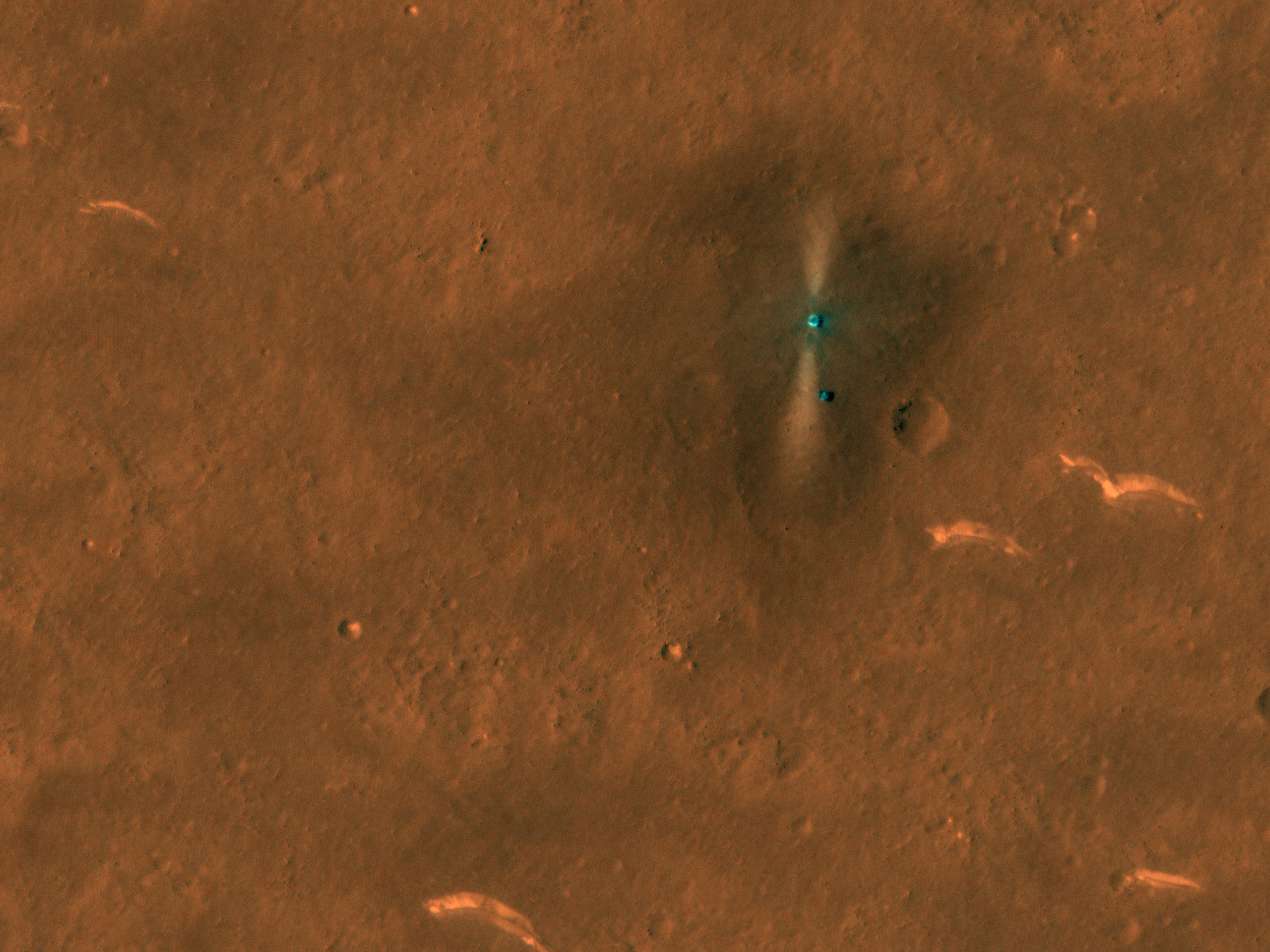
Tianwen-1's orbiter High Resolution Camera finally came up with a photo of the lander/rover landing site, taken on June 2 10:00 UTC.
From lower left to upper right: Heat Shield, Parachute/Backshell, Rover, Lander.
Interesting to see the rover seems to have barely moved at all since rolling off on May 22...
Source

From lower left to upper right: Heat Shield, Parachute/Backshell, Rover, Lander.
Interesting to see the rover seems to have barely moved at all since rolling off on May 22...
Source
QUOTE (Cosmic Penguin @ Jun 7 2021, 06:53 AM)
From lower left to upper right: Heat Shield, Parachute/Backshell, Rover, Lander.
100 m blast on the terrain.?.. I thought the diference of clarity on the images was due to sun angle.. That explain a lot.
So C is a crater... a clear 20m crater near the rover...
QUOTE (tolis @ May 20 2021, 06:42 AM)
On the b&w image there is a dark band just in front of the bright patches near the horizon that appears to be lined with rocky debris,
especially on the right hand side. Wonder if are looking at a subdued crater rim here.
Tolis got it right on.especially on the right hand side. Wonder if are looking at a subdued crater rim here.
A, B and E the white clear patterns and D is a mount on a crater wall. So D is 200 m distance.
If the images are North oriented, it landed with the rover facing east, the bright blast jets are pointing North South and Zhurong has actually moved around the lander.
Rover runing, and they are clearly holding images and data from release.
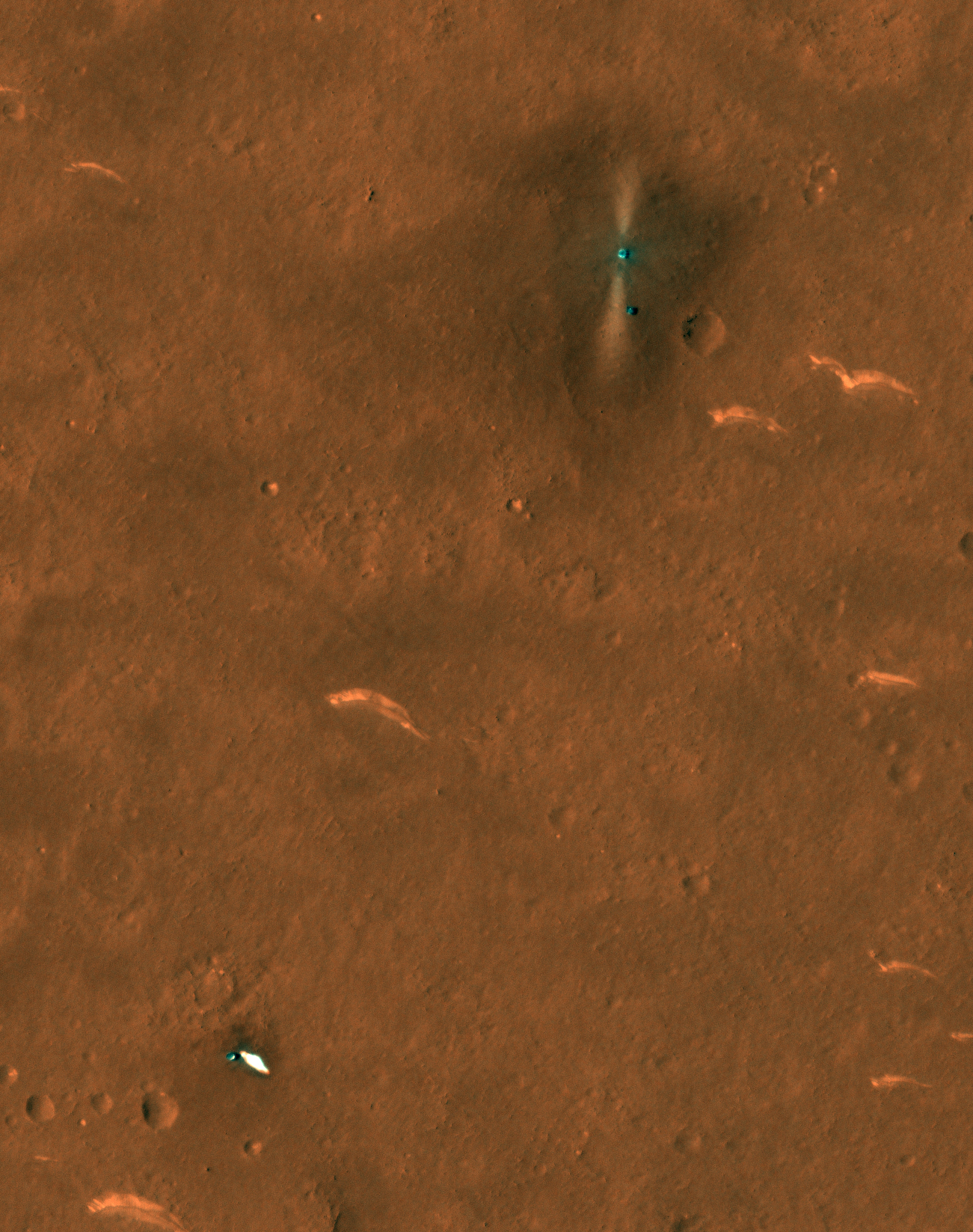
Peter Grindrod has found the exact location using MROs Context Camera photos (CTX image F04_037553_2068), he puts the landing coordinates as 25.066N, 109.926E: https://twitter.com/peter_grindrod/status/1...9215457281?s=21
The new image allows refining the position relative to the uncertainty bounding box:
Click to view attachment
Assuming my registration of the underlying CTX image is not too far off, the new coordinates are (+/- 3m):
Zhurong: 25.0654°N 109.9258°E
Parachute/Back-shell: 25.0599°N 109.9237°E
Heat-shield: 25.0494°N 109.9012°E
Fernando
Click to view attachment
Assuming my registration of the underlying CTX image is not too far off, the new coordinates are (+/- 3m):
Zhurong: 25.0654°N 109.9258°E
Parachute/Back-shell: 25.0599°N 109.9237°E
Heat-shield: 25.0494°N 109.9012°E
Fernando
Very good orbiter images. We can actually see the lander ramp. Probably the rover has made a 120o clockwise turn in the lander on this orbiter photo.
Im impressed how easy is to analyse the terrain between the Zhurong and orbiter images.
Im impressed how easy is to analyse the terrain between the Zhurong and orbiter images.
On equalized version, of the only colored image we got, we have a beige dusty forming the terrain together with white stones. I presume this stones are of similar composition of the big white wave patterns on the site. For me it resambles vulcanic rocks, like rhyolite or purnice, not my field, help wanted here..
QUOTE (Huguet @ Jun 7 2021, 10:33 AM)
If the images are North oriented, it landed with the rover facing east, the bright blast jets are pointing North South and Zhurong has actually moved around the lander.
Would that put the rover on the side of the lander bearing the Chinese flag?
QUOTE (tolis @ Jun 7 2021, 12:42 PM)
Would that put the rover on the side of the lander bearing the Chinese flag?
Perfectly put... it probably means we will got this selfies next.
If you kinda squint a little* you can kinda see something that might be tracks.
(*admittedly, not the most scientific analysis).
(*admittedly, not the most scientific analysis).
QUOTE (Hungry4info @ Jun 7 2021, 01:01 PM)
If you kinda squint a little* you can kinda see something that might be tracks.
(*admittedly, not the most scientific analysis).
(*admittedly, not the most scientific analysis).
if we consider the half grey mark at the image,.. the rover would be completing the turn over the lander, with 6 or 7 stop points. Hey Casc,,, we need more data. Will you share it please?
Too much to keep up with on Mars today! I'll be catching up soon.
It's not clear to me if Zhurong has moved 90 degrees clockwise of 270 degrees counterclockwise around the lander but either way it will be facing the flag now, as pointed out above. We'll get rover images of the tracks eventually. HiRISE will help too.
Phil
It's not clear to me if Zhurong has moved 90 degrees clockwise of 270 degrees counterclockwise around the lander but either way it will be facing the flag now, as pointed out above. We'll get rover images of the tracks eventually. HiRISE will help too.
Phil
a little closeup of the Zhurong lander and rover
Click to view attachment
Click to view attachment
Mars Reconnaissance Orbiter's HiRISE has now also taken photos of the landing site on June 6, showing the rover making a slight move in 4 days since the TW-1 orbiter photos were taken.

QUOTE (Cosmic Penguin @ Jun 10 2021, 06:16 AM)
Mars Reconnaissance Orbiter's HiRISE has now also taken photos of the landing site on June 6, showing the rover making a slight move in 4 days since the TW-1 orbiter photos were taken.
Zhurong is at a crater wall on this photo. It just landed beetween 3 huge craters. With lots of smallers ones nearby. Very good pic from Hirise. almost a 10cm per pixel image. Im very impressed. We can see lots of the lander and zhurong details, directions...
A surprise, we can't see tracks. So this terrain is a lot less dust and more rock then the terrain on chang'e 4 path.... (zoom equalized to increase details on RGB), we have lots of craters, the smallest i can see on hirise with 1 meter diameter. and the big 3 towards the lander. (2 almost gone e 1 more visible). Thats crazy, so much more details then i would expect.. Hirise has just imaged like a airplane... Mabe they can reduce more the distance without hitting the atmosphere, or it was the safe limit?
If i was casc,.. i would put zhurong on the direction of the parachute, to survey mars, but to take most information of all the hardware.. One of the top objective would be master the landing process (knowing the efects on every hardware part).
QUOTE (Huguet @ Jun 10 2021, 03:29 AM)
is at a crater wall on this photo. It just landed beetween 3 Very good pic from Hirise. almost a 10cm per pixel image.
Where do you get that number from?
HiRISE has a max of 25cm/px
QUOTE (djellison @ Jun 10 2021, 11:52 AM)
HiRISE has a max of 25cm/px
QUOTE (Greenish @ May 24 2021, 01:16 PM)
source: Bin Zhou et al 2020. With this and other images (such as hi-res press rendering here)I estimate the obstacle avoidance cameras as ~700-750mm above nominal ground level.
Click to view attachment
Click to view attachment
QUOTE (Cosmic Penguin @ Jun 10 2021, 06:16 AM)
Mars Reconnaissance Orbiter's HiRISE has now also taken photos of the landing site on June 6, showing the rover making a slight move in 4 days since the TW-1 orbiter photos were taken.
Its giving me 14.77 cm/px, almost 10 but not 10... Here follows a better calculation. Maybe the 25 cm is the worlst of the best, and in some cases its a little better. But its really less then that, the ramp is 20 cm and would be dificult to see on a 25 cm/px image.
The tracks area reduced like in the last Rear Photo, and the ramp is less then 20 cm... lot less, It is 3 tiny 2->5 cm pieces together in 20 cm..
QUOTE (Huguet @ Jun 10 2021, 07:12 AM)
Its giving me 14.77 cm/px, almost 10 but not 10... Here follows a better calculation. Maybe the 25 cm is the worlst of the best, and in some cases its a little better. But its really less then that, the ramp is 20 cm and would be dificult to see on a 25 cm/px image.
You are measuring an image that has already been blown up. HiRISE is between 30 and 25 cm per pixel. Thats what it does.
QUOTE (djellison @ Jun 10 2021, 01:01 PM)
You are measuring an image that has already been blown up. HiRISE is between 30 and 25 cm per pixel. Thats what it does.
Can be. I used the image on the Hirise Site: https://www.uahirise.org/hipod/ESP_069665_2055.
If the image is raw, then its a little better resolution, if not they blown it up by almost 200%.
Here follows the original on the site and the detail with 10 px grid.
QUOTE (Huguet @ Jun 10 2021, 09:18 AM)
Can be.
OK - not to belabor this point. HiRISE has a resolution of between 25 and 30cm/pixel. That's not something we need to debate here. That's just a fact.
https://www.uahirise.org/specs/
https://hirise-pds.lpl.arizona.edu/PDS/DOCU...ISE_EDR_SIS.PDF
QUOTE (djellison @ Jun 10 2021, 01:25 PM)
OK - not to belabor this point. HiRISE has a resolution of between 25 and 30cm/pixel. That's not something we need to debate here. That's just a fact.
Im not saying they don't generate 25 to 30 cm /px, because we all have standards. That image on 14 cm is not good. But if you scale it to 28 it has clean pixels. Here follows the image on 28 cm/px. Maybe, just maybe, that was a raw pic, and forgive me but i love raw data, in any case the Hirise specification is 20.000 red px on 6km length at 300km altitude and i indeed can be wrong, but that was a fantastic work, the ramp is sharp clean to see on the site image.
I give up.
HiRISE may not be resolving the lander ramp, but may be simply imaging the glint of sunlight off of the ramp components.
But whatever. It's an accomplishment on an accomplishment.
I'm interested in seeing the light-toned flatish rocks up close, here as well as at Jezero. Call me old-fashioned, but I've been a fan of the "Whiterock Formation" for years...
But whatever. It's an accomplishment on an accomplishment.
I'm interested in seeing the light-toned flatish rocks up close, here as well as at Jezero. Call me old-fashioned, but I've been a fan of the "Whiterock Formation" for years...
Exactly what "resolution" means can be debated (pointlessly, IMHO) and can be different from "pixel scale". And sometimes you can see things that are below the resolution limit if they are sufficiently contrasty.
The actual image is now available for your resolution measurement needs:
https://www.uahirise.org/ESP_069665_2055
to mcaplinger: not to mention that effective resolution can differ between the along track and across track directions...
https://www.uahirise.org/ESP_069665_2055
to mcaplinger: not to mention that effective resolution can differ between the along track and across track directions...
QUOTE (volcanopele @ Jun 10 2021, 02:24 PM)
The actual image is now available for your resolution measurement needs:
I give up: Original IRB jp2 image has the lander with 14 px. The lander on the final processed image has more or less 23 px, which would give it aproximately 18 cm if the res on lander is 29.2. It is actualy exagerated on the maped version, and indeed a good work.
This is a "lo-fi" version of our main content. To view the full version with more information, formatting and images, please click here.