Andreas Plesch
Jun 21 2021, 02:58 PM
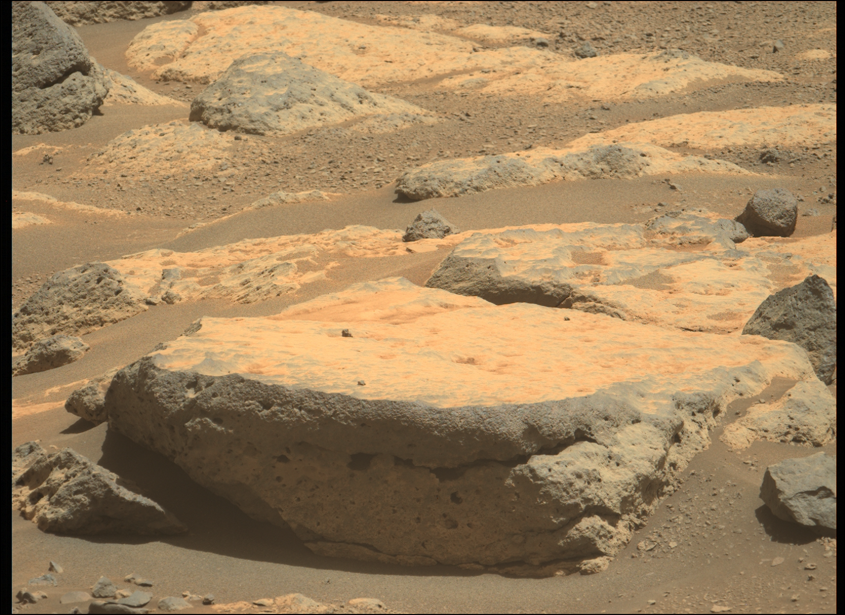
I found this sol 119 Zcam image near the border to the Seitah intriguing:
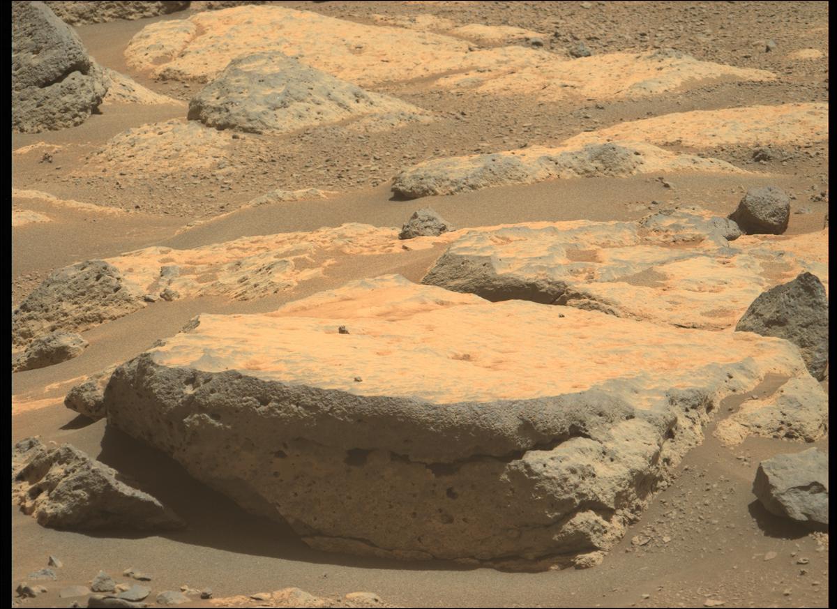 https://mars.nasa.gov/mars2020-raw-images/p...0_01_295J01.png
 has Navcam context.
It shows clearly how the bright weathering, platy appearance of the surface often observed in the area, can be a result of the development of a very thin, dusty,
weathering "rind"or coating of vesicular to more massive, weakly layered basalts.
The
sol 106 crater rim panorama showed potential contacts of these units with sedimentary units below (although the imaged blocks may have been completely overturned during ejection).
serpens
Jun 27 2021, 03:01 AM
Indicative of abrasive weathering creating ventifacts as well as spalling from temperature variation? Evidence seems to be mounting for effusive lava layer(s) covering eroded sedimentary deposits.
JRehling
Jun 27 2021, 03:30 AM
With a deep appreciation for the geological expertise of others, I'm going to try to put this in terminology that's clear but hopefully not too simplistic: Perseverance is in Jezero because we care about the layers that formed below the waterline in the lake. Once upon a time, as the lake dried up, those would have been layered chronologically with the oldest stuff on the bottom and the newest stuff – including the places where the rocks reflected the most evolved (take that as you will!) lake chemistry – on top.
But now, the top of the delta may contain few to none of those newest sedimentary layers, the rocks from which are perhaps lying, scattered about, with overlying or admixed material in the crater floor. The rock that is most interesting is already around us, but broken up and taken out of the context where we ideally would have found it if ~3-4 GYA of erosion hadn't taken place. So the crater floor phase of the traverse is going to be very important, but perhaps very challenging as we have to figure out which jigsaw pieces came from where.
Then, when we actually get to the bottom edge of the delta, it will be a jump back in time to older (perhaps not the oldest) sedimentary rock that formed in Jezero, and we'll go slowly forward in time from there, until we get to the top of the delta. And we may encounter the youngest sedimentary rock up there, but the devil's in the details as to how much of it is still up there.
Remarkably, if this is true, we're going to get the history of Jezero in medias res, very much like The Odyssey, where we begin the story near the end, then go back to the beginning and gradually catch up to where we started… and then perhaps up atop the delta, get to the end of the story.
HSchirmer
Jun 27 2021, 03:13 PM
QUOTE (serpens @ Jun 27 2021, 03:01 AM)

Indicative of abrasive weathering creating ventifacts as well as spalling from temperature variation? Evidence seems to be mounting for effusive lava layer(s) covering eroded sedimentary deposits.
It reminds me of some of the New Jersey's 'orange mountain basalt' exposures- a basin is filling with sediment, and also has periodic volcanic activity, some eruptions on the surface, some intruded between existing layered sediments-
What is INTERESTING, is that the upwelling magma ascended through layers of differently compacted material- essentially 'stone' at the bottom, then less and less compressed material until sand and dirt - as you trend upward. Which MIGHT help to evaluate how compacted the Jezro material was when it was altered by volcanic activity.
Quick follow up- you often find vesicles from gasses in the basalt, BUT you will also find vesicles in the altered/baked 'hornfels' sedimentary material around the magma/lava from water flashing to steam. I believe you can estimate how compacted / deep the sediments were based on vesicles, to give you a water/sediment ratio...
stevesliva
Jun 27 2021, 05:07 PM
Maybe already covered here, but here's a pictorial of crossbedding and conglomerate in Delta Scarp:
https://www.jpl.nasa.gov/news/my-favorite-m...ers-delta-scarp
Greenish
Jun 28 2021, 02:12 AM
QUOTE (JRehling @ Jun 26 2021, 11:30 PM)
...terminology that's clear but hopefully not too simplistic....
Thank you, this is very helpful.
Bill Harris
Aug 31 2021, 11:45 PM
QUOTE (JRehling @ Jun 26 2021, 10:30 PM)
With a deep appreciation for the geological expertise of others, I'm going to try to put this in terminology that's clear but hopefully not too simplistic:
snip
This is a good explanation. Jezero is a huge and complex jigsaw puzzle. For the past 3-4BYA there have been many depositional and erosionsl episodes, some of which involve reworking of older rocks. And as said, we won't understand things until we work our way to the end, and then work back down to the beginning. And hopefully we'll find a field chronological Rosetta Stone to nail the timeline down with.
At any rate this will be an interesting project to follow.
--Bill
Explorer1
Sep 10 2021, 03:52 PM
Sample collection briefing coming here in a few minutes:
https://www.youtube.com/watch?v=IMyuOBexwE0
Julius
Sep 11 2021, 11:41 AM
Watched the update yesterday. Interesting find of igneous rocks altered by water. Was this lava deposited at the time when Jezero was a lake or did the contact with water happen after it was laid down on the crater floor?
Bill Harris
Sep 11 2021, 03:38 PM
Is a transcript of that briefing available yet?
My initial guess would be that this is basalt from the adjacent Syrtis Major area and subsequently weathered. It might mean that the basalt was emplaced onto a lake.
And so the story unfolds...
--Bill
Andreas Plesch
Sep 11 2021, 03:39 PM
QUOTE (Julius @ Sep 11 2021, 06:41 AM)
Watched the update yesterday. Interesting find of igneous rocks altered by water. Was this lava deposited at the time when Jezero was a lake or did the contact with water happen after it was laid down on the crater floor?
Thanks for the link. It is good to have confirmation that the sample is from a volcanic rock, likely basalt, vesicular to varying degrees, and has Ca sulfates and phosphates resulting from waters percolating. So some water was there after or during the emplacement or deposition of the basalts. The most straightforward explanation is that the volcanism predates the lake phase, or occurred during an early lake phase. To me, the volcanics appear to be intercalated with laminated clastics in some outcrops we have seen sofar. This would indicate volcanism extending into an early lake. This does not exclude a later, post lake, post erosion phase of volcanism which I think is the current model for some mappable units.
serpens
Sep 12 2021, 06:42 AM
The first drill target was located in a depression and was definitely a poorly consolidated, clastic sedimentary rock. To me this tends to indicate it was, as Tim Demko said, a last gasp fluvial deposit as the lake dried up. We then climbed to parallel the ridge skirting Seitah which dips south. As this has been identified as a basaltic (magma) deposit this could indicate the eroded remnant of an effusive onlap which covered sedimentary deposits and embayed Seitah. The magma would have interacted with hydrated minerals and potentially even buried ice deposits which could have caused the vesticular aspect. There is also the possibility of ephemeral water from snow/ice subsequent to the magma deposit.
Julius
Sep 12 2021, 09:02 AM
[quote name='serpens' date='Sep 12 2021, 07:42 AM' post='254442']
The first drill target was located in a depression and was definitely a poorly consolidated, clastic sedimentary rock. To me this tends to indicate it was, as Tim Demko said, a last gasp fluvial deposit as the lake dried up. We then climbed to parallel the ridge skirting Seitah which dips south. As this has been identified as a basaltic (magma) deposit this could indicate the eroded remnant of an effusive onlap which covered sedimentary deposits and embayed Seitah. The magma would have interacted with hydrated minerals and potentially even buried ice deposits which could have caused the vesticular aspect. There is also the possibility of ephemeral water from snow/ice subsequent to the magma deposit.
The update stated both targets at Rubion and Rochette seem to be more or less the same rock type (igneous) except Rubion contains more salt and therfore more weathered by water. They plan another attempt at a core sample at Rubion
Bill Harris
Sep 12 2021, 09:08 AM
It is going to be an interesting study to look at the nature of the basalt flows: mineralogy, texture and age. And details: what soils were they emplaced upon? We're they emplaced into water? Freshwater lake, it brine seas? And remember, we're looking at multiple depositional-weathering-erosional-repeat events under different climates. With no tectonics to 'wipe the slate', we're writing over and around previous entries.
--Bill
serpens
Sep 12 2021, 11:53 AM
All rocks in Jezero should have an igneous provenance whether effusive emplacement, sedimentary made up of igneous particles and fragments or float from the crater walls .
Despite the stunning technology Perseverance is somewhat limited with respect to analysis and it could be difficult to differentiate between such. I suspect that is the reason for the less than definitive "Rubion and Rochette seem to be more or less the same rock type",
centsworth_II
Sep 12 2021, 01:18 PM
One thing mentioned in the briefing was sharp-angled crystals in rock as opposed to rounded being used to destinguish igneous rock from sedimentary rock composed of of igneous grains.
tdemko
Sep 12 2021, 05:12 PM
QUOTE (centsworth_II @ Sep 12 2021, 08:18 AM)
One thing mentioned in the briefing was sharp-angled crystals in rock as opposed to rounded being used to destinguish igneous rock from sedimentary rock composed of of igneous grains.
They did say that, but when I was looking at the image they were talking about, I saw plenty of very round grains or clasts, too! I also hear a bit of equivocation when phrases like "originated as an igneous rock" are used instead of "this is an igneous rock". Much of the data is geochemical, and many volcaniclastic rocks are indistinguishable from their volcanic parents geochemically. The presence of the pervasive sulfate salts is also intriguing. Basalts, like most igneous rocks, have very poor permeability, although vesicles may make them porous. Either the alteration has increased the permeability such that the fluids could permeate evenly through the matrix of the rock, or it had some pre-existing porosity and permeability to allow the fluids to precipitate freely in the intragranular spaces. I think the jury is still out on sedimentary or not. The bedded nature of the outcrops sure looks like stratified sediments. I've seen no features that look like they were formed by lava or lava-water interactions.
serpens
Sep 12 2021, 11:10 PM
The angular particles (clasts?) do indicate limited transportation but this can result from a larger piece transported into the crater, subsequently breaking up into smaller, angular fragments. If Rochette were found to be sedimentary then the ridge could be a remnant of Seitah.
Bill Harris
Sep 12 2021, 11:59 PM
Although the vesicles increase Porosity, unless they are interconnected they may not have good Transmissivity. Fluids may be transmitted secondarily through fractures or bedding planes (or the surfaces between individual flow events). Much like the groundwater flow in an indurated sandstone with fractures.
Until we get 'thin sections' of these rocks, we won't know the details. I'm wondering if the early minerals in the lava (olivines) don't abrade and round during rapid flow (transportation) with the later minerals (amphiboles) growing into angular crystals once the lava cools and slows.
--Bill
moustifouette
Oct 8 2021, 02:20 PM
Hello,
Some update from the ground.
science Article
Julius
Oct 8 2021, 03:23 PM
I am thinking it is more challenging for the Rover team to understand what is happening on the crater floor than when we eventually get to the delta.
tdemko
Oct 8 2021, 07:18 PM
QUOTE (Julius @ Oct 8 2021, 10:23 AM)
I am thinking it is more challenging for the Rover team to understand what is happening on the crater floor than when we eventually get to the delta.
I attended a talk this week by Farah Alibay (one of the Perseverance engineers) which was an update on Perseverance and Ingenuity. There was a Q&A at the end, and I asked her whether the rover could/would approach cliff faces, or if the arm could reach under ledges to examine recessive strata in outcrops.
Short answer, no.
Long answer, they are very protective of their baby.
serpens
Oct 8 2021, 11:00 PM
Thanks for the link moustifouette (mosquito net). For A2 I'm sticking with my perception that it is flood induced scour fill.
HSchirmer
Oct 9 2021, 11:20 AM
There's a new paper on Kodiak?
Jezero lake was closed (no outlet river) at the time of the delta progradation at Kodiak, which is a hydrological system conducive to short-term fluctuations in the lake level. Nevertheless, the overall stratigraphy indicates progradation of the western delta system and long-term lake level regression.
https://www.science.org/doi/10.1126/science.abl4051EDIT- Ok, same paper as yesterday-
Bill Harris
Oct 9 2021, 11:58 AM
QUOTE (tdemko @ Oct 8 2021, 02:18 PM)
snip
...and I asked her whether the rover could/would approach cliff faces, or if the arm could reach under ledges to examine recessive strata in outcrops.
Short answer, no.
Long answer, they are very protective of their baby.
That makes sense. Even as a carbon-based Rover I'm cautious about getting too close to a highwall.
--Bill
Bill Harris
Oct 10 2021, 01:04 AM
Does anyone know the area of the area of the catchment basin (ie, watershed) above Jezero crater? I remember reading it at one time, but haven't come across it again.
--Bill
serpens
Oct 10 2021, 01:39 AM
Goudge and others estimate the catchment of the western valley as around 12,000 km2 and the northern valley as 18,700 km2, but there has been a lot of reworking of the catchments and in the South by encroaching lava so there could be error bars attached to those estimates.
The supplemental notes and data with the linked article are well worth a read. Looking at the detailed image of Kodiak in that data, I believe it is an eroded remnant of a lower section of delta deposits that were once covered by later deposits. I still feel that the deposits above the truncated foresets on the right could possibly be bottomsets from a later deposition following a period of erosion, noting that the topset/foreset transition on the left is much higher.
There would have been repeated surges in the fluvial system as erosion of the inlet through the crater wall progressed. Just to the East of the breach there seems to be a higher nickpoint in the channel and perhaps some evidence of water buildup before breaching. Given the significant fall into the crater from this nickpoint and almost certainly repeated collapses at the inlet gap, the transportation and deposit of sizeable detritus could be expected. But it was a pleasure to read this article and get the expert's opinions to compare with our own expert's. (Take a bow Tim).
Bill Harris
Oct 10 2021, 07:40 AM
I have no doubt that the history of this site will complex beyond imagination. It is not just one event: it will clearly be multiple episodes of deposition and erosion under differing climactic conditions.
But it is going to be fascinating to engage in arm-waving for the next few years as data trickles in. Ah, to be out on-site bouncing from by the to by the or to have a post-Ginny UAS flitting from outcrop to outcrop.
I didn't see your Link to the article.
--Bill
serpens
Oct 10 2021, 09:39 AM
The download link at the end of the 'Science' article from limoustifouette's post. Right before References and Notes.
tdemko
Oct 10 2021, 07:33 PM
QUOTE (serpens @ Oct 9 2021, 08:39 PM)
Given the significant fall into the crater from this nickpoint and almost certainly repeated collapses at the inlet gap, the transportation and deposit of sizeable detritus could be expected. But it was a pleasure to read this article and get the expert's opinions to compare with our own expert's. (Take a bow Tim).
(Bowing deeply...)
I would caution the interpretation of unit a2 as having foreset cross strata. The finer-grained overlying a2 strata and underlying a1 strata are dipping in different apparent directions.
An alternative interpretation is that the crudely cross-stratified a2 strata are backsets, and therefore exhibiting the same apparent paleoflow directions as the underlying and overlying strata.
These types of backset coarse successions are typical of migrating cyclic step bedforms, the result of traction deposition under supercritical flow conditions.
Bill Harris
Oct 10 2021, 08:15 PM
Do we have a feel for the flow velocities based on the particle (and boulder) size. And/or guesstimates of the flow volumes at various times, realizing that flows were likely episodic and ephemeral.
--Bill
serpens
Oct 10 2021, 10:37 PM
Supercritical flow, chute and pool, scour fill. It all hangs together. But with respect to velocity, for supercritical flows, inertia must exceed gravity. So the Froude number must be greater than 1 which means that the flow velocity must exceed (g*depth)^1/2. This provides minimum flow velocities as a function of depth of: 1m 2.12 m/s, 2m 2.4 m/s, 3m 2.6 m/s, 4m 2.8m/s. It is obvious that large boulders were moved, possibly by what may have been a short flash flood or could have been an extended period of high velocity flow. But it could be assumed that there would be a lot of entrained sediment which would influence the force while the low gravity would reduce friction and assist lift.
tdemko
Oct 11 2021, 02:10 AM
QUOTE (serpens @ Oct 10 2021, 05:37 PM)
Supercritical flow, chute and pool, scour fill. It all hangs together. But with respect to velocity, for supercritical flows, inertia must exceed gravity. So the Froude number must be greater than 1 which means that the flow velocity must exceed (g*depth)^1/2. This provides minimum flow velocities as a function of depth of: 1m 2.12 m/s, 2m 2.4 m/s, 3m 2.6 m/s, 4m 2.8m/s. It is obvious that large boulders were moved, possibly by what may have been a short flash flood or could have been an extended period of high velocity flow. But it could be assumed that there would be a lot of entrained sediment which would influence the force while the low gravity would reduce friction and assist lift.
This holds if the flows were open channel, with a free surface at the water/atmosphere interface.
On the other hand, if these were subaqueous sediment gravity flows, then the gravity is "reduced" since the flow interface is between the sediment-laden flow and the ambient water. The gravity term in Froude number equation is modified by the density difference between the two. This is the reason that cyclic steps and antidunes are stable in supercritical subaqueous sediment gravity flows (and basal surge and pyroclastic flows, although there the density difference is between ash-laden flows and air), and unstable to transient in supercritical open channel flows.
serpens
Oct 12 2021, 08:53 AM
QUOTE (Bill Harris @ Oct 10 2021, 08:15 PM)
Do we have a feel for the flow velocities based on the particle (and boulder) size. And/or guesstimates of the flow volumes at various times, realizing that flows were likely episodic and ephemeral.
Bill, just in case you haven't read it, the supplementary data I referred to provides estimates of flow velocity and volume along with methodology. The analysis seems to assume that the Delta scarp represents a cross section perpendicular to flow. Looking at the orientation of Kodiak compared to the Delta scarp and what appears to be foresets to the right of A2 for me the current scarp would appear to be at a reasonable angle to the flood flow.
Bill Harris
Oct 12 2021, 07:32 PM
QUOTE (moustifouette @ Oct 8 2021, 09:20 AM)
Hello,
Some update from the ground.
science ArticleMercy me.
One downside to browsing via Smartphone is that font sizes here can vary and sometimes one misses seeing Links.
I just now saw this link from a couple of pages back.
Re-presented in the Quote so we don't need to thumb back...
serpens
Oct 15 2021, 02:54 AM
QUOTE (tdemko @ Oct 10 2021, 07:33 PM)
I would caution the interpretation of unit a2 as having foreset cross strata. The finer-grained overlying a2 strata and underlying a1 strata are dipping in different apparent directions.
I have been unable to find where A2 was identified to have foreset cross strata. Could you point me on the right path?
tdemko
Oct 15 2021, 04:19 PM
QUOTE (serpens @ Oct 14 2021, 09:54 PM)
I have been unable to find where A2 was identified to have foreset cross strata. Could you point me on the right path?
From the section "Implications for hydrologic evolution and sample return":
"The boulder conglomerates in units a2, b2 and k5 (Fig. 1) indicate repeated flood episodes of variable intensities. These deposits are distinct from the low- to moderate-energy fluvial deposits characteristic of river-dominated deltas (19). Their stratigraphic positions overlying delta deposits indicate that they are also unlikely to be sediment gravity flow deposits formed in a deep lacustrine setting. We cannot determine whether the boulder conglomerates were deposited when a lake still existed in Jezero crater. Their geometry is consistent with fluvial deposits on Earth that show downstream transition to gravel-to-sand Gilbert-type underwater
foresets (29)."
serpens
Oct 16 2021, 02:52 AM
Thanks Tim. I think when I read that I made the error of thinking downstream transition meant further downstream from the deposits under discussion.
tdemko
Oct 16 2021, 06:34 PM
QUOTE (serpens @ Oct 15 2021, 09:52 PM)
Thanks Tim. I think when I read that I made the error of thinking downstream transition meant further downstream from the deposits under discussion.
Now that I've re-read it, you may be right. It's ambiguous as to whether they are referring to the described deposits or some transition downstream.
I think that a1, a2, and a3 could all be the deposits of subaqueous sediment gravity flows. I also think the authors are not familiar with the coarse-grained bedload deposits of short, steep sublacustrine or submarine fans dominated by supercritical flow. They are just equating coarse grained deposits with fluvial deposition.
Time for an analog field trip!!!
Bill Harris
Oct 16 2021, 06:52 PM
We need to start thinking in terms of desert flash floods with short-duration intense peak flows, and large sediment loads as well as huge bed loads. Definitely not a temperate -style hydrologic cycle.
Has anyone (besides Mars2020 mission planners) gone and pieced together orbital imagery of the Jezero watershed?
--Bill
serpens
Oct 16 2021, 11:35 PM
From what we have seen of the delta front and Kodiak it seems to reflect delta growth into a lake under a stable flow regime with episodes of erosion reflecting dry periods and also a few periods of high intensity flow. My obviously deranged imagination pictures gently flowing river dominated deltas under cloudy skies at the edge of a choppy lake with an ocean visible to the East. In reality it was probably a more violent environment but I like the illusion.
Periodic high intensity flows transporting sizeable detritus both rounded and angular does not necessarily imply a desert flash flood or dry environment. It could reflect a gradual increase in flow to high intensity flood levels due to the progressive melting of abnormally large deposits of snow in the catchment or perhaps the collapse of obstructions at the crater inlet breach or the knickpoint further up the channel. Currently we are in the realm of hypothesis and dare I say imagination and Tim's last post highlights the fact that we have two plausible but opposed explanations for A2 from experts in the field although I don't believe they are mutually exclusive across the delta front.
For imagery of the watersheds try
https://www.arcgis.com/home/webmap/viewer.h...78.2144,20.7779
JRehling
Oct 17 2021, 03:37 PM
Perhaps I'm wrong in associating wildly different phenomena with just one facet of similarity, but we've known for a long time that Mars had catastrophic, massive floods in its past, and then we had a long campaign of exploration that led us to discover and characterize these other kinds of water flow, due to climate, more typical of Earth, but should we then think of all of the water flow that took place in Jezero as the latter and not the former?
As Mars had (and has) massive deposits of crustal ice, this allowed volcanic activity to unleash massive floods that are endogenous in origin, not due to climate. Similarly, impact melt could accomplish the same result.
We know that the overall topography of Jezero was reworked by the rise of Syrtis Major to its immediate west. We moreover know from the eroded crater present on the delta that there was still significant impact cratering taking place after the time frame of the delta's formation; it's therefore plausible that as much or even (far?) more impact cratering took place during the time frame of the delta. The signs are abundant on Mars of lobate flows created by the impact melt of subsurface ice. For that matter, the kinetic (rather than thermal) result of an impact hitting a watershed would be yet another potential cause of catastrophic water flow.
It seems to me that it remains to be proven if any flash flooding was due to anything we'd associate with climate versus those two non-climate catastrophic scenarios.
In addition, we know that Mars has likely had cycles of axial tilt leading to climate changes wildly more catastrophic than what Earth has experienced which could have created climate epochs where ice would form locally, then other epochs in which there would be a lot of cumulative melt.
It seems to me that all of these and more are in play as potential explanations.
tdemko
Oct 17 2021, 04:12 PM

QUOTE (JRehling @ Oct 17 2021, 10:37 AM)
It seems to me that all of these and more are in play as potential explanations.
I completely agree. However, the well-organized delta foreset strata at Kodiak, and the organization of channels and lobes from the orbital imagery suggest that sustained, or at least seasonal, flows probably built a significant volume of the deltaic deposits.
On the other hand, the catastrophic events like you've mentioned can also be important in shaping the geomorphology of lakes, and can produce significant deposits in lake basin fills.
Here is one of my favorite examples, from Lake Tahoe in the USA. A huge landslide deposited giant blocks on the lake floor, but also created tsunami and seiche flows which formed fields and channels of antidune and cyclic steps deposits around the lake margin as they returned back into the lake as supercritical flows. The point of my previous posts was that the authors of the Jezero paper don't seem to be familiar with these types of deposits, or even recognize that supercritical sediment gravity flows would also be expected in the types of short, steep, coarse-grained delta deposits that have been seen in Kodiak.
https://www.researchgate.net/publication/25...lifornia-Nevada
HSchirmer
Oct 17 2021, 06:03 PM
QUOTE (Bill Harris @ Oct 16 2021, 07:52 PM)
We need to start thinking in terms of desert flash floods with short-duration intense peak flows, and large sediment loads as well as huge bed loads. Definitely not a temperate -style hydrologic cycle.
I'd add: debris/mud flows,
and
perhaps river/estuary bores? Jezro may be at the Arabian ocean shoreline, so not tidal bore, but ocean impact bore.
After seeing videos of a the debris font of a Utah flash-flood/debris flow, and then the wave front of a Chinese tidal bore-
I realized where Hayao Miyazaki (anime filmmaker) got his inspiration:
-The motion of debris at the front of a desert flash flood-
 https://youtu.be/_yCnQuILmsM?t=236
appears to be the influence for the writhing demon Nago-No-Kami in the film "Princess Mononoke"

-The motion of cresting waves at the reflected front of a tidal bore in Qiantang River
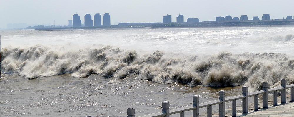 https://youtu.be/k6fr6GUSmAA?t=70
appears to be the influence for the water spirit Ponyo-

Debris flow. = rain in the desert, ice dam breaking, impact into ice-rich terrain.
Tusnami / tidal bore.= crater lake impact, marsquake, or a crater wall landslide.
Bill Harris
Oct 18 2021, 01:55 AM
Preface: let me suggest that I'm not going on a Catastrophism kick with this. It's that I've been accustomed to Mars' typically subtle and gentle erosional processes that I'm shifting my mindset for more pronounced processes.
I'm sure that for the most part the delta formation has been slow and steady with moderate streamflows and sedimentation rates. But this has been punctuated and accentuated with violent episodic events over thousands or even millions of years. And Mars has has profound climate changes over those years, ranging from moist and temperate to dry and cold.
Engaging discussions here.
--Bill
serpens
Oct 18 2021, 06:52 AM
After a long look at A1,2,3 over a glass of very nice wine I am now moving firmly into Tim's corner. A lot of delta front A is covered by scree but if the dipping beds to the right are indeed foresets then the direction if flow would be primarily right to left and the line of partially exposed horizontal rock leading from its upper edge to the top of the a2 fill could possibly be remnant topsets. Hypothetical of course but that fits Tim's diagnosis.
HSchirmer
Oct 18 2021, 06:32 PM
QUOTE (Bill Harris @ Oct 18 2021, 01:55 AM)
Preface: let me suggest that I'm not going on a Catastrophism kick with this. It's that I've been accustomed to Mars' typically subtle and gentle erosional processes that I'm shifting my mindset for more pronounced processes.
I'm sure that for the most part the delta formation has been slow and steady with moderate streamflows and sedimentation rates. But this has been punctuated and accentuated with violent episodic events over thousands or even millions of years. And Mars has has profound climate changes over those years, ranging from moist and temperate to dry and cold.
Engaging discussions here.
--Bill
Well, it helps to remember that Earth's 23° tilt varies over time.
https://climate.nasa.gov/news/2948/milankov...earths-climate/https://www.smithsonianmag.com/science-natu...rery-180971615/QUOTE
https://www.ldeo.columbia.edu/~polsen/nbcp/...ry_abstract.pdf the Newark Basin Coring Project
(NBCP) of the 1990s, which recovered 6700 m of continuous Triassic-Jurassic (230 to 199 MA) lacustrine core, was the first to demonstrate a strong deviation in the period of the Mars-Earth eccentricity (g3 – g4) cycle from the present (5). That cycle now has a period of 2.4 m.y., but during the Late Triassic and Early Jurassic it was about 1.8 to 1.6 m.y., a deviation attributable to chaotic diffusion in planetary gravitational interactions
And Mar's tilt is expected to vary even more often.

First rule of short-term geology - "glaciers were created to annoy geologists by shuffling rocks"
https://www.nasa.gov/mission_pages/msl/mult...a/pia15095.html
Bill Harris
Oct 18 2021, 10:12 PM
And Earth has stabilizing factors such as a large Moon and temperature-regulating oceans that Mars does not have.
https://agupubs.onlinelibrary.wiley.com/doi...29/2008GL034954
serpens
Oct 18 2021, 11:02 PM
But given the increasing evidence, may have had when Jezero was a lake.
cIclops
Oct 21 2021, 02:22 PM
This is a "lo-fi" version of our main content. To view the full version with more information, formatting and images, please
click here.