Full Version: Charon Surface Observations: NH Post-Encounter Phase
This topic is for images and discussion of same received after 1 Aug 2015.
QUOTE (fredk @ Aug 2 2015, 07:50 PM) 
What makes you say that?
Yes, frame was taken 2015-07-16 03:44:20 UTC, more than a day after encounter.
Post deleted. Sorry for my mistake.
QUOTE (Gennady Ionov @ Aug 2 2015, 08:49 AM)
the Sun is behind the Charon's disc
What makes you say that? The size of Charon in that post-encounter frame is roughly similar to its size in this frame:
http://pluto.jhuapl.edu/soc/Pluto-Encounte...0x632_sci_1.jpg
That pre-encounter frame was taken more than a day before closest approach, so the post-encounter frame had to be taken roughly a day after closest approach. But the Charon-sun occultation occured only 2h 15m after closest approach. So the sun must be outside the frame on that Charon crescent image.
The picture fredk linked was taken from a range of 1,462,006 km, according to the metadata file.
The crescent image was taken from a range of 1,986,740 km, according to the metadata file, and since apparent diameter has a simple, inverse relationship with distance, Charon should be about 73.6% the size it was in the image fredk linked.
Not that that adds anything to the conversation
The crescent image was taken from a range of 1,986,740 km, according to the metadata file, and since apparent diameter has a simple, inverse relationship with distance, Charon should be about 73.6% the size it was in the image fredk linked.
Not that that adds anything to the conversation
QUOTE (JRehling @ Aug 4 2015, 11:04 PM)
Checking the orbital positions, there were Charonshine opportunities for imaging Pluto on July 14, July 20, etc. and Plutoshine opportunities for imaging Charon on July 17, July 23, etc.
If we get some regional albedo information for the mid-southern latitudes, that would be great. A bonus would be if we get some details and/or could see if Charon has a dark region at the other pole, too. I'd love to see something like the Saturnshine images of Iapetus, but I'm not getting my hopes up.
If we get some regional albedo information for the mid-southern latitudes, that would be great. A bonus would be if we get some details and/or could see if Charon has a dark region at the other pole, too. I'd love to see something like the Saturnshine images of Iapetus, but I'm not getting my hopes up.
Yes! I hope that Charon has a dark region at the southern pole, because I believe that Mordor Regio resulted from leakage of ice from the equator in the relaxation process of Charon nonsphericity during deceleration of rotation.
This appears to be a ~ half-size (5000px wide vs 9520px wide) of the previously-released PIA19866 with no new data added, for those who have the earlier map.
http://photojournal.jpl.nasa.gov/catalog/PIA19866
--Bill
http://photojournal.jpl.nasa.gov/catalog/PIA19866
--Bill
Here is an updated version of my map of Charon. The main changes are the addition of color (areas where no color was available are colorized) and the addition of a single 400 m/pixel image. Compared to the official map, there are some positional errors (typically ~10 pixels; more near the pole) but they do not affect the overall appearance of the map. Longitude 0 is at the left edge of the map.
Click to view attachment
I'll probably redo the map completely at higher resolution later this year.
Click to view attachment
I'll probably redo the map completely at higher resolution later this year.
Nice map. I appreciate in particular the images are blended more smoothly at the boundaries than we often see in the official versions.
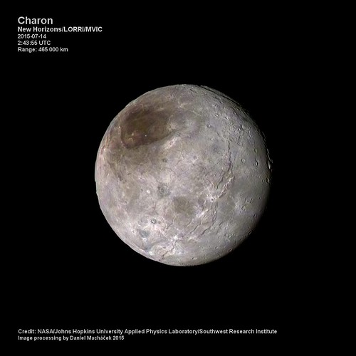
Charon is turning out to be a delightfully complex and fascinating world. It has a polar crater-caldera, a system of lineations with a complex equatorial fracture system, a cratering history and a north-south dichotomy as well as seasonal frosts. Much more than the little Pluto tag-along we were thinking it was.
I am doing a presentation on the Geomorphology of Charon. As always, it is a work-in-progress, so check back:
LORRI-MVIC combined imagery
https://univ.smugmug.com/New-Horizons-Missi...2B%20MVIC-L.png
Preliminary Geomorph of Charon
https://univ.smugmug.com/New-Horizons-Missi...orph-v1.0-L.png
--Bill
I am doing a presentation on the Geomorphology of Charon. As always, it is a work-in-progress, so check back:
LORRI-MVIC combined imagery
https://univ.smugmug.com/New-Horizons-Missi...2B%20MVIC-L.png
Preliminary Geomorph of Charon
https://univ.smugmug.com/New-Horizons-Missi...orph-v1.0-L.png
--Bill
Upgraded image released
I wonder if this means other LORRI images currently posted will be replaced by less compressed versions tomorrow.
QUOTE
This image of Pluto's largest moon Charon, taken by NASA's New Horizons spacecraft 10 hours before its closest approach to Pluto on July 14, 2015 from a distance of 290,000 miles (470,000 kilometers), is a recently downlinked, much higher quality version of a Charon image released on July 15.
I wonder if this means other LORRI images currently posted will be replaced by less compressed versions tomorrow.
Charon's north pole looks to me like it could have a relatively young surface - or just having craters as dark as their surroundings?
Click to view attachment
Click to view attachment
NH Blog post today about how the red pole may be tholins left behind after some of Pluto's atmosphere freezes onto Charon's dark pole, only to sublimate away leaving behind trace tholins:
https://blogs.nasa.gov/pluto/2015/09/09/new...arons-red-pole/
https://blogs.nasa.gov/pluto/2015/09/09/new...arons-red-pole/
Colorized image of Charon from the newly published images.
2 stacked images colorized using MVIC data.
Resolution 2.3 km/pix.
2 stacked images colorized using MVIC data.
Resolution 2.3 km/pix.

QUOTE (stevesliva @ Sep 10 2015, 08:19 PM)
NH Blog post today about how the red pole may be tholins left behind after some of Pluto's atmosphere freezes onto Charon's dark pole, only to sublimate away leaving behind trace tholins:
Nice theory. If correct this must be a very slow or no longer active process as we see a few bright impact craters punched into it.
Wonderful image NH/machi.

new images as the LORRI site
http://pluto.jhuapl.edu/soc/Pluto-Encounte...er=downlinkDate
http://pluto.jhuapl.edu/soc/Pluto-Encounte...er=downlinkDate
Baby mountain-in-a-moat? 
Click to view attachment
(notice the difference to the similar-sized crater next to it)
In general, quite a lot of mountainous structures on those plains.
Click to view attachment
(notice the difference to the similar-sized crater next to it)
In general, quite a lot of mountainous structures on those plains.
QUOTE (Gennady Ionov @ Aug 3 2015, 07:30 PM)
Another interesting feature of relief: small dimples. I suppose that it is an analogue of the dunes in the desert, caused not by the wind but solar irradiation conditions.
Oriented to the Sun the north side evaporates and on the shady south sides condensation occurs. Thus, the instability of a flat surface develops and slowly creeping dunes to the south (when in the northern hemisphere is summer). Therefore, the perpendicular meridians orientation of formations can be observed.
Oriented to the Sun the north side evaporates and on the shady south sides condensation occurs. Thus, the instability of a flat surface develops and slowly creeping dunes to the south (when in the northern hemisphere is summer). Therefore, the perpendicular meridians orientation of formations can be observed.
It looks like the similar dunes seen on Charon. Dunes caused by instability of flat surface due to instability under slanting rays of the sun.
At least Charon dunes definitely can not be caused by wind.
Click to view attachment
QUOTE (Alan)
new images as the LORRI site
They do have the Additn'l Info as "LORRI rider on P_MPAN_1 scan observation", and there is an button to show by release date, but I don't see any _release_date_ info on the images. Have I missed something?
and a reminder of my NH Charon geomorph image:
https://univ.smugmug.com/New-Horizons-Missi...omorph-v1.0.png
--Bill
from
http://pluto.jhuapl.edu/soc/Pluto-Encounte...;br>10:29:23
a 3d look down the canyon
Click to view attachment Click to view attachment
http://pluto.jhuapl.edu/soc/Pluto-Encounte...;br>10:29:23
a 3d look down the canyon
Click to view attachment Click to view attachment
Charon looks far less cratered than Callisto, Ceres, Mimas, Tethys, Dione, Rhea, and Iapetus (plus Umbriel, Titania, and Oberon based on lower resolution images).
Perhaps we're looking at a surface age closer to that of Ganymede, Miranda, and Ariel?
Perhaps we're looking at a surface age closer to that of Ganymede, Miranda, and Ariel?
My attempt at stitching together the Charon mosaic that was uploaded on the raw website today. Tried my hand at colorizing it with the MVIC image taken on July 13. I had to warp the image to align with low resolution + Charon's rotation making that difficult, so color features should be taken with a *huge* grain of salt.
Really nice work Justin !
With the latest high-resolution imagery down, it really looks like there is significant topography at the north pole (there certainly is on the horizon). Using jccwrt's work above (rotated to make north up(wards)), it's tempting to interpret this part as a mountain range (perhaps encircling the entire northernmost area), entering and leaving the field of view on the right side in this image:
Click to view attachment
I also found this crater interesting, since it appeared kind of shallow - as if something had happened to its floor:
Click to view attachment
And of course there is this crater (to the right), which looks completely filled in:
Click to view attachment
Dome?
Click to view attachment
Landslides from some of the big cliffs:
Click to view attachment Click to view attachment
(look impact-related)
Click to view attachment
I also found this crater interesting, since it appeared kind of shallow - as if something had happened to its floor:
Click to view attachment
And of course there is this crater (to the right), which looks completely filled in:
Click to view attachment
Dome?
Click to view attachment
Landslides from some of the big cliffs:
Click to view attachment Click to view attachment
(look impact-related)
It seems that Charon has Cerean topography, especially the "flowage" and "slumpage" features.
And my take on Mordor (the Polar Feature) is that it appears to be a caldera/crater.
Ref my "Pluto/Charon" and "Ceres" pages linked below.
What strange little worlds.
--Bill
And my take on Mordor (the Polar Feature) is that it appears to be a caldera/crater.
Ref my "Pluto/Charon" and "Ceres" pages linked below.
What strange little worlds.
--Bill
QUOTE (neo56 @ Sep 26 2015, 02:42 AM)
Really nice work Justin !
Thank you!
QUOTE (Habukaz @ Sep 26 2015, 10:21 AM)
With the latest high-resolution imagery down, it really looks like there is significant topography at the north pole (there certainly is on the horizon). Using jccwrt's work above (rotated to make north up(wards)), it's tempting to interpret this part as a mountain range (perhaps encircling the entire northernmost area), entering and leaving the field of view on the right side in this image.
It could be a mountain range. My first thought was that it was another large fissure system seen edge on. Of course, at the scale of some of these, there's functionally not much difference!
 It is interesting that it is "walling in" some of the darker terrain around the north pole - I wonder if it's either creating a cold trap that keeps the north pole in winter darkness for a little longer.
As for the infilled crater, it looks pretty old and degraded, so there's a possibility that it could just be infilled with ejecta from other impacts. That said it's on relatively flat terrain so there might have been some mare-like flow into the crater. Hopefully we'll get another hi-res image to get some context to the eastern rim of that crater.
This crater (directly north of Moat Mountain) looks interesting, could be a potential terrace impact. Looks relatively young, too. Some of the ejecta is covering nearby tectonic features.
Click to view attachment
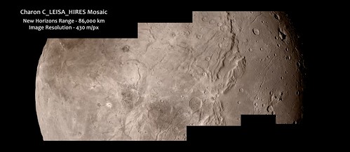
These latest Charon images, five in a montage-able series described as "LORRI rider on C_LEISA_HIRES scan" are a great improvement on the initial Charon images.
When these images hit PDS as verified and calibrated etc they should be better than these initial jpeg'd public offerings, so there is room for improvement.
But with later data transfer from NH, should there be higher resolution images of this series to look forward to? And could there be other images north and south of these to give a montage of the entire hemisphere or was this one track pretty much it?
Still, these images show astounding detail and amazing features on this little world. Take a look:
https://univ.smugmug.com/New-Horizons-Missi...haron/i-wQNMfhT
--Bill
According to machi's table of planned LORRI observations it appears there was a scan across Charon at 170 m/px resolution. As for the C_LEISA_HIRES observation, there were apparently 12 shots planned in this sequence. I'm not sure if that means that this will cover the entire globe of Charon or if there were just multiple images taken to increase SNR like some of the LORRI observations of Pluto. Considering that this is a ride-along observation, I'd guess the latter.
There was a mosaic taken at 175,000 km which should cover the entire hemisphere at a resolution 0.87km/px ,similar to the 16 frame mosaic of Pluto posted a couple of weeks ago; an MVIC color image from 76,000 km, resolution 1.5km/px; and a narrow pass from 34,000 km, resolution 0.17km/px, with a concurrent MVIC image at 0.66km/px.
Still, that is good. The recent images have so much going on. Later images transmitted and images on-the-ground-but-going-to PDS can only sweeten things.
https://univ.smugmug.com/New-Horizons-Missi..._5x1--annot.png
--Bill
https://univ.smugmug.com/New-Horizons-Missi..._5x1--annot.png
--Bill
QUOTE (peter59 @ Oct 1 2015, 12:06 PM)
And more details:
What is the highest resolution we expect? I recall reading it in a journal article that I no longer have a link to. Something around 140 M/pixel is what comes to mind.
Whoa. Great images today for us Charon-ites.
Good color:
http://pluto.jhuapl.edu/Multimedia/Science...mp;image_id=323
The hi-res track with color:
http://pluto.jhuapl.edu/Multimedia/Science...mp;image_id=324
Charon and Pluto:
http://pluto.jhuapl.edu/Multimedia/Science...mp;image_id=325
A CGI riff:
http://pluto.jhuapl.edu/Multimedia/Science...mp;image_id=326
And of course, that '70's Gold to hum along with, by The Knack: "My Charona":
www.youtube.com/watch?v=g1T71PGd-J0
I'll be up for air by Sunday...
--Bill
Does anyone know, at what point on Charon's surface is the center of the Pluto-facing side?
Zero lat, zero longitude?
That would certainly be a logical convention for mapping... and I believe the correct one. The caption to the first Charon map released by nasa was:
Global map of Charon as of July 30, 2015. The map is in simple cylindrical projection, with zero longitude (the Pluto-facing direction) in the center. It includes all available resolved images of the moons surface captured between July 7-14, 2015 on the anti-Pluto facing hemisphere. Image credit: NASA / Johns Hopkins University Applied Physics Laboratory / Southwest Research Institute.
Global map of Charon as of July 30, 2015. The map is in simple cylindrical projection, with zero longitude (the Pluto-facing direction) in the center. It includes all available resolved images of the moons surface captured between July 7-14, 2015 on the anti-Pluto facing hemisphere. Image credit: NASA / Johns Hopkins University Applied Physics Laboratory / Southwest Research Institute.
Could you add a link? (If you did, I can't see it from my device).
QUOTE (Hungry4info @ Oct 2 2015, 10:24 PM)
Could you add a link? (If you did, I can't see it from my device).
Is it the map linked in posts 6 and 7 of this thread?
Yes, the maps in posts #6 & #7. Link
Got it. I thought you were suggesting there was a newer map that included the most recently released imagery.
The recently released image is so beautiful, I'm not really looking forward to seeing it embedded in a cylindrical map with the low resolution fuzz all around...
This one is from Apollo 11, rigth?
Has anyone made an updated map for Charon?
It almost looks like this island broke apart from the mainland, was carried off and then listed in the Great Melt of the southern hemisphere.
Note how some of the parts fit, similar to South America and Africa.
Click to view attachment
Note how some of the parts fit, similar to South America and Africa.
Click to view attachment
(Newbie here.) This track is not an image artefact, is it? The lower right corner indicates its location.
Click to view attachment
Click to view attachment
This is a "lo-fi" version of our main content. To view the full version with more information, formatting and images, please click here.