Sherbert
Jul 24 2015, 07:02 AM
QUOTE (JRehling @ Jul 23 2015, 09:36 PM)

I've inadvertently stolen this thinking in musings on the Pluto Near Flyby thread.
I'm just glad to see others are thinking similarly. I did not know about that phase change. As Bill says the other super volatiles are going to have their different influences. The Tombaugh region is mainly about CO, but the majority of Pluto is about Nitrogen and Methane. It is perhaps unfortunate that the NH close flyby is over this "aberration" on Pluto's surface. The images from North and East of Tombaugh will hopefully tell us more about pre impact Pluto, which one suspects is a lot more sedate.
The Cthulhu region near the impact area has steep cliffs, but away from there the sides of the basin appear a far more gentle slope. I'm thinking the depression is more an illusion created by mountainous terrain to the North and South of the equator. It may be at a similar level to the plains of the "temperate latitudes". Flows of Pluto's atmosphere travelling from "warm" to "cold" are going to travel to points where the vapour pressure and temperature conditions mean the gases, Nitrogen and Methane mainly, are going to freeze and collect. The axial tilt obviously messes with this simplified scenario, the predominant flow appears to be North to South. The "Ropey" mountains are in my eyes the Northern extent of the Southern mountains. This flow has definitely helped to spread Carbon Monoxide from the impact site, South, over the Sputnik Plain and on down towards the equator. Both aeolian transport and sublimation/deposition seem likely to be involved, modifying the initial overflow from the impact basin at the time of the impact, to create the current landscape.
xflare
Jul 24 2015, 04:54 PM
I think the heart, at least the left side, is a vast cryovolcanic lava flow.
Gladstoner
Jul 24 2015, 10:12 PM
QUOTE (xflare @ Jul 24 2015, 11:54 AM)
I think the heart, at least the left side, is a vast cryovolcanic lava flow.
West Tombaugh Regio does appear more like a caldera with a lava lake than (what I think of as) a glacier.
marsbug
Jul 25 2015, 03:48 PM
Looking at the images of the 'nitrogen glaciers', I'm reminded that the solubility of water ice in liquid nitrogen is unexpectedly high:
http://link.springer.com/chapter/10.1007/9...4613-9865-3_113https://inis.iaea.org/search/search.aspx?orig_q=RN:16033601given how ell these glaciers seem to flow, is a liquid component in microveins within the bulk ice a possibility I wonder, and has it been slowly eating its way into the water ice 'bedrock'? That would make the whole system a very interesting experiment into a large scale physical and chemical system the likes of which we simply could not do on earth.
Rittmann
Jul 25 2015, 05:54 PM
Looking at the images I've come to some ideas that, so far, I have not seen from anyone. Since they are essentially speculative, I'll put them in this thread and not in the encounter thread.
1.- Equatorial dark band
Looking at the surface of Pluto and its crater distribution so far, I am under the impression that cratering is essentially on the equator. We can see in the maps that resurfacing has happened in the northern latituted, and Tombaugh region is very young, but the Cthulhu region has several craters, some of them filled with the dark element.
One of the first ideas that came to my mind was the possibility of a collapsed ring system around the equator. Before the encounter it had been commented that the Pluto system could feature a transient ring system created from dust from its moons. In the turbulent gravity environment of Pluto, with the barycenter far from the planet surface and Charon's pull affecting assymetrically the space around pluto, I speculate that instead of a ring system, dust would rain towards the planet's surface and collapse around the equator. Tidal locking with Charon would have affected the deposition over time, making two differentiate patterns. Craters would then have higher chances to happen around the equator if they were fragments of the original event that created the current system's configuration, and as time went by, would have rained down on Pluto's equator along the dark dust. Charon's influence would have prevented a slim ring to form, raining over a range of equatorial latitudes instead.
This idea has its own weak points. It doesn't explain Charon's dark pole - there should also be an equatorial belt in the moon -. It also doesn't explain why there appear to be dark materials on the peaks of some mountains.
In this scenario the original impact that created the double planet would have caused full resurfacing of Pluto and Charon, and over time Pluto would have received the rain of dust over its surface, along with some debris.
2.- Energy source for Pluto's current resurfacing
A global scale resurfacing event is likely to have happened in the event that created the Pluto / Charon system, if as it seems, it was created by an impact.
Pluto's mass is (1.305±0.007)×10^22 kg. It currently loses 500 metric tonnes of material every hour according to the data. Assuming a constant rate - which is a lot of assuming, since I believe Tombaugh is currently the biggest source for mass loss in the planet due to its young volatile exposed ices, in contrast with the older areas - we have the following numbers:
4.38*10^9 kg /year
1.971*10^19 kg in 4.5 billion years
We are three orders of magnitud below the whole planet's mass here, but this mass was originally only on the surface. Pluto's surface area is 1.77×10^7 km2, so on the current surface of Pluto could have lost over the life span of the Solar System 1.110 metric tonnes of mass per square meter.
Considering that the possibility for sub-surface liquid masses has been estimated in the scale of meters, makes me propose the following hypothesis: as surface mass is lost, underground liquid masses are able to expand due to the release of pressure. These masses could, in some places, crack causing faults - ices tend to be brittle - releasing on the surface as they expanded against the almost void of the surface of the planet.
In the areas where this first happened the process would speed up since the exposed clean ices from the underground lakes would sublimate at a higher pace than older, more stable surfaces. This would release faster enough pressure for even more underground deposits to burst into the surface, including water deposits.
According to this idea, Tombaugh region would have been the place where the liquid underground sources would have been nearest to the surface - it is more or less the exact anti-Charon area, so that could have influence through tidal heating in the past -. Once enough surface ices sublimated into the atmosphere and space, the pressure release would have caused the first nitrogen and CO underground sources to burst, flooding the surface and speeding up the process. As the process sped up, deeper sources with liquid water would have also bursted, causing the ice mountains to show up over the nitrogen and CO plains.
In the first hi-res image we can see several faults across older surface south of Tombaugh, but none of the faults seems to be affecting any mountain in the area.
Furthermore, this would explain the shorelines since the plains' surface would have sublimated over time, leaving the original terminators of the expansion process - still made of materials that don't as easily sublimate - to remain.
PD. My first post in this fantastic forum!
ZLD
Jul 25 2015, 08:42 PM
Just to throw an idea out thats been rattling around in my head for the past week, with regard to the Tombaugh Regio area, I don't believe it is or was a an impact. Looking around the rim, there are areas that would allude to it being crater like but if there is tectonic activity, it could possibly form much of what is visible as well, more on this in a bit.
Let's back up a little. In 1989, Pluto was at perihelion and conditions were most favorable for the densest possible atmosphere from seasonal change. In the time since, the surface pressure appeared to be increasing until a rapid falloff observed by REX. During yesterday's science update, they didn't appear to have the data from the SOPHIA occulation observation. So we can't rule out the possibility that there could be error in the way atmospheric pressure is calculated during a distant occultation, or there could be an error in reading the REX data, or some other unforeseen error elsewhere. However, lets continue to assume everything is correct and accurate. This leaves the question as to why pressure would increase and suddenly fall off, especially with the abundant and constant release of nitrogen that is escaping.
Back to Tombaugh Regio. Blatantly, I feel the area is currently and has been a sea for a very long time, possibly composed of nitrogen. There well established areas that look like shorelines, theres what appears to be migration through the region, lack of any visible impact craters and very strange linear or polygonal features that overlay the region. During an earlier press briefing, an idea that this looked like a boiling liquid really piqued my interest.
A large assumption to suggest but if Pluto had a slightly denser than measured atmosphere during perihelion then this nitrogen sea may have been liquid at the surface, maybe even for just a few years. Then as Pluto began to cool off again, the atmosphere began to refreeze, decreasing pressure to a point where the nitrogen sea began to boil and eventually settled with a relatively thin membrane over the still liquid sea. As this action was occurring, it could have possibly thrown off atmospheric measurements as the nitrogen was boiling away and escaping into space. A large amount of nitrogen still escapes the body, possibly through the linear features in the region as well.
Back to tectonics. This is really out there but looking over the wonderful maps by scalbers, the area previously referred to as the 'train tracks' looks like it shares some similarities to Tombaugh Regio. I mentioned a while back from my versions of the stacked approach data, that it seemed like Cthulu possibly sat slightly above the mean terrain. I still personally see that in some regard with the higher resolution images. These dark areas may be a sort of continental plate and the bright areas like Tombaugh Regio more like a sea floor plate. The biggest contributor to this idea is the segment of the surface, running along the west side of TR. It appears very strikingly like a rift valley forming, and not simply ice burgs breaking away. If the previous maps of Pluto are at all accurate (they seem to be), then there is likely even more of the bright areas in the south that make up these sea plates. This further lends to why the dark regions would appear to be heavily bombarded relative to TR. As for the northern ice covered terrain, there appears to be a difference in types and maybe numbers of cratering between the areas just north of TR and just north of Cthulu. This could indicate that under this ice sheet is a continuation of these differing plates, softening craters over the less viscous areas.
scalbers
Jul 25 2015, 10:33 PM
QUOTE (Rittmann @ Jul 25 2015, 05:54 PM)
PD. My first post in this fantastic forum!
Welcome to the forum Rittman. I would like to check if your numbers come out better using the mass loss value I recall hearing, of 500 tons per hour?
Rittmann
Jul 26 2015, 09:53 AM
Whoops! True. I've edited the post to match things. But this means that Pluto, assuming a constant loss rate from its birth - which is a lot of assuming - has lost 1/500th of its mass due to this process.
1.110 tonnes per square meter, if we use the density of N2 ice at Pluto's temperature as 1.35g/cm3, means a column of approximately 1500 meters per square meter. That is a lot!
My conjecture, though, is that the current escape rate is working at a far faster pace due to Tombaugh region's popping up having happened relatively in recent times - 100MY, for example -. Older, "baked" areas like the equatorial dark belt would have practically stopped sublimating elements since the dark material coating the terrain would act as some kind of protection - thus, the apparent surface is also older since this mechanism would have no power to resurface the area.
But if we account Tombaugh as the main area where sublimation is happening, and the event that bursted the current ices over its plains as 100MY old, then we can formulate a rough approximation:
1.- Tombaugh's exposed ices, even if it is a reduced region through Pluto, account for, let's say, 25% contribution to the overall mass loss.
2.- This increased rate has happened only during the last 100MY.
3.- I don't have the total surface area of Tombaugh regio. I will assume an approximate shape of a circle and an approximate diameter of 1200km. This gives a rough total area of 1.13*10^6 km2
So, 125 metric tonnes per hour from Tombaugh regio for 100MY gives:
1.- Mass loss: 1.095*10^17 kg during 100MY
2.- 97 metric tons per square meter of mass loss
This gives a total loss of approximately 77 meters of mass loss over the surface during 100 MY.
Considering that some think that the liquid layer for Pluto's characteristics may be just a few dozen meters below the surface, we may have here a plausible mechanism for the surface renewal. Add to this that the figures are all very rough, so a surface 200MY old would give 150 meters of mass loss, carving the shorelines we see. Or Tombaugh regio could account for far more mass loss than just 25% since it is not "baked", speeding up the process.
Why this area? If the wobbling we see by the moon tides on Earth is any reference, Tombaugh regio being anti Charon would be one of the highest original elevation areas in Pluto, or at least one that would have been the most active during the tidal locking with the moon, providing a source of energy over a long time during Pluto's history, and creating a concentration of pools near the surface.
All in all, here is my speculation for a mechanism for resurfacing of the planet.
Bill Harris
Jul 26 2015, 10:23 AM
Not bad First Posts and welcome, Rittman. The Pluto-Charon system is an amazing world and with new (and improved) images arriving almost daily our knowledge of the system is evolving at that rate. These are wonderful times.
I am working up a "Poster Session" on the geomorphology of Pluto. This is, of course, presently a work-in-progress, and the initial Index image is at:
https://univ.smugmug.com/New-Horizons-Mission/PlutoCharon/--Bill
Bill Harris
Jul 26 2015, 10:44 AM
QUOTE (Rittman)
...Considering that some think that the liquid layer for Pluto's characteristics may be just a few dozen meters below the surface, we may have here a plausible mechanism for the surface renewal. Add to this that the figures are all very rough, so a surface 200MY old would give 150 meters of mass loss, carving the shorelines we see. Or Tombaugh regio could account for far more mass loss than just 25% since it is not "baked", speeding up the process...
Yes. And look at the phase diagrams for Nitrogen and Methane that I have seen posted here-- the triple point is attainable at reasonable temperatures and pressures. And that is not even considering the properties of admixtures of Nitrogen with other gases such as CH4, NH4, CO, CO2. Nor the properties of clathrates with the forms of water ice.
I am by no means a cryochemist/physicist so all this is mind-boggling to me.
--Bill
dvandorn
Jul 26 2015, 02:45 PM
Also, I've not seen this mentioned specifically, perhaps the weight of the equatorial ice cap that is Tombaugh Regio is compressing the underlying water ice crust and causing the tectonic cracking we see around the region. Specifically, I'm thinking this could be the mechanism that created the radial cracks coming away from the region and extending into the Cthulu region.
That would make as much or more sense to me as the radial cracking being caused by an impact. Other basin-like impacts into icy worlds, like Callisto, for example, generate cracking in concentric rings around the impact point. These are cracks extending outward radially from the center of what appears to be a gigantic pile of nitrogen ice covered by a layer of CO ice. The weight of that pile could be what's deforming the surrounding terrain and causing the radial cracking.
-the other Doug
MarsInMyLifetime
Jul 26 2015, 03:47 PM
Several interesting things jumped out to me following this past week's briefing:
First, the Eastern contact of the convection zone against the weathered terrain looks remarkably straight, and I can no longer reconcile its shape with a presumed border of an impact crater--I think that other hypotheses are now called for. Clearly the big story is about the apparent convective upwelling of ductile nitrogen ice. The relatively straight contact zone suggests an interaction of that zone with something about the "bedrock" itself such as a fault or more durable composition.
Second, the image of presumed glacier-like activity presented yesterday shows some fractures in the weathered surface
parallel with the contact zone (not the radial lines mentioned before). Rather than the soft ice encroaching over the weathered surface like lava, I have the mental image of crust being subducted underneath the active flow region of the convection cells, and being fractured by the stress of the downward dive at the edge.
Click to view attachmentSo my latest line of thought, trying to align with the obvious convection activity, is to view the region as a slow but voracious geologic hotspot, a material reprocessing factory that is gnawing its way northward through the older plate, leaving a trail of various after-effects to the south and east. This still does not explain carbon monixide production that wells back up in the Sputnik Planum surface; the most obvious thing I can imagine is that the carbon monoxide, in a much earlier history, was differentiated as a layer that the hotspot is now upwelling through.
hendric
Jul 27 2015, 06:03 PM
Will Ralph give us direct temperature measurements from the surface? Based on the descriptions I read, we only get indirect temps based on presence of N2, H2O, and CO.
Even with the JWST, it looks like we won't have enough resolution to monitor regional temp changes on Pluto, other than at the Earth-facing hemisphere level (JWST is .1", Pluto's angular size is about .1" as well.)
If Tombaugh Regio really is shrinking vs Hubble pics, then those margins between the ice and the hills have to be pretty dynamic to show a change in so "short" a time - especially since the change looks geologic and not just a veneer sublimating away.I am really very confused as to Sputnik Planum's temperature relative to the surrounding areas. My gut say the center must be warmer, to cause the overturning and CO release, but being as white as it is, my brain says it must be colder. Maybe a temperature reading across Sputnik Planum looks like a crater cross section, with warm edges from the darker Cthulhu, a warm center from a Hawaii-esque hot spot, and a ring of colder plains. I think the whitest area in the center probably stays year-round on Pluto, with the light gray and darker gray portions extending out during the night time growth stage - collecting debris from underneath, and melting/sublimating back during the daytime shrinking stage.
Another possibility is TR has no heat source, but is a thicker section of ice that survives the summer, acting as a seed (or more likely several seeds) for the winter expansion. One weird effect we don't get to see much on Earth anymore would be the glaciers growing up-valley vs down-valley. This is caused by the ice starting growth at the colder shaded bottoms of craters/valleys, spotty across the landscape, vs collecting at the top of cold peaks as on Earth due to precipitation. As it expands, the initial layers are put down directly without flow at the margins, and once it gets thick enough, probably at the center or in very shaded valleys, it starts flowing outwards. This would help explain the dichotomy of light grey & dark grey. The light grey happens during the initial layers phase, with material picked up as the layer grows mostly vertical - there would be less darker material the higher up the valley it goes and so when they meet the ridges show up whiter that the rest. This would help to explain the isolated mounts with grey areas and white spokes, like in NW SP. The central white area is where it all started, and enough ice has grown there to push out all the grey.
But as it gets thick enough to start flowing, then it switches modes to gather the darker grey material at the edges via flow. This would cause the dark grey material to thicken into a black line once two neighboring glaciers connect over a ridge. This effect would be most noticeable where there is a slow elevation change, explaining the NE area of SP having the most of these. A shallow rise with ridges allow for most of the darker material to stay close to where it started and meet up with material from the other side of the ridge. Some hand-waving might necessary when the glacier gets high enough that it tumbles over a ridge that doesn't have another glacier on the other side, but there are a few candidate features to the SE.
Darker material collecting above/along the ridges where two glaciers meet could also cause the fractures/trenches - as more ice collected in the cold center of the glacier, the darker material causes the trenches via melt, eventually melting deep enough that the overturning ice above it covers it up, leaving a remainder line.
In the summer, the dark material starts near the top of the ridges because of the effect above, but as it progresses falls down the valley sides, allowing the cycle to repeat.
This second idea fails on explaining the source of CO. Perhaps the ice sheet is thick enough in the center that the bottom heats CO and it can escape via the weak spots made by the dark material at the margins of the cells. It does explain the cells though as the seed cores of the glaciers that started growth in the winter. With them being white it would tend to self-reinforce the growth, potentially continuing well into summer or even year-round.
JRehling
Jul 27 2015, 07:31 PM
Before this month, the observed changes in Pluto were always inferred to be "weather" related, because Pluto was assumed to be geologically dead. Now, however, it's open to speculation if any of the changes that we've observed over the decades were weather-related as opposed to the aftermath of geological events. We haven't watched it long enough to tell the difference. (Indeed, we would have to have records going back to about William the Conqueror's time to be sure.)
Pluto's orbital period is still short compared to many geological timescales (e.g., major impacts), but it may not be short compared to the frequency of some kinds of endogenous activity. Imagine, a world with non-zero weather where weather might be slower than geology.
hendric
Jul 27 2015, 08:21 PM
Good point, the "shrinking" of TR could be caused by the overturning slowing down as Pluto leaves summer, letting more of the tholins stay on the surface on the cells as they slow down and stop.
Bill Harris
Aug 2 2015, 01:54 AM
With the 250-year year plus the orbital eccentricity plus the axial tilt, Pluto is bound to have significant seasonal variability. We'll need to monitor it for a while...
--Bill
HSchirmer
Aug 9 2015, 04:19 PM
QUOTE (MarsInMyLifetime @ Jul 26 2015, 03:47 PM)
Click to view attachmentSo my latest line of thought, trying to align with the obvious convection activity, is to view the region as a slow but voracious geologic hotspot, a material reprocessing factory that is gnawing its way northward through the older plate, leaving a trail of various after-effects to the south and east. This still does not explain carbon monixide production that wells back up in the Sputnik Planum surface; the most obvious thing I can imagine is that the carbon monoxide, in a much earlier history, was differentiated as a layer that the hotspot is now upwelling through.
Perhaps you are seeing cracks from glacial rebound, as the sunlit edge of Tombaugh recedes and is reistributed "south" and "east" in those "snowdrift" bands?
Consider a planet where "atmospheric pressure" could also mean the pressure exerted by a collapsing atomsphere freezing out as a slab.
The atmosphere itself IS the meteorological cycle of precipitation.
With an elliptical orbit, IIRC P&C at closest (circa 1990) get 2.8 times the illumination and heat than at farthest in 1880s;
With axial tilt, 1990's closest approach and 1880s fathest are both during equinox, you get "rotisserie mode" where the entire planet is exposed to sunlight.
We are seeing the planet as it moves towards solstice, or "broiler mode" where the total amount of solar flux is less, but it is concentrated
on only one hemisphere.
I also wonder whether this could be a glacial cold-trap, a growing pile of condensed atmosphere with a covering of CO hoarfrost or ice-spire "pennitents"
I wonder whether this might be a CO "deccan traps", an ice flood that has erupted from below.
We're not sure whether flood basalts on earth are a result of a focused plume of geologic heat or an impact or both.
If Tombaugh is antipodal to Charon, you might have some sort of tidal stress connection, rather like enceladus tiger stripes.
HSchirmer
Aug 26 2015, 05:00 PM
QUOTE (Sherbert @ Aug 26 2015, 01:41 AM)
The Ralph data showing the large amounts of Carbon Monoxide in the Tombaugh Regio with almost no evidence of its presence elsewhere and the Water ice mountains. Both are anomalies. An impact scenario, possibly including an "airburst", bringing Carbon Monoxide to the surface is my pick as a possible explanation, on the evidence available so far anyway.
Penetration by an impactor of a layer of Carbon Monoxide ice, or a postulated liquid CO "aquifer", below the surface, leading to an explosive release of pressure, liquid and gas, subsurface and surface volatile ices liquifying add to this to fill and overflow the crater. In addition, what look like once "molten" crater walls, possible "splash" zones, a plausible impact basin and strong evidence of fluid flow covering older surfaces, all seem to me to fit such a scenario. Elsewhere in the Solar System, such large resurfacing events are frequently the result of impacts.
One might hypothesise that "solid" material, such as Water ice, possibly in the impactor, caught up in such an "explosive decompression" combined with massive volumes of rapidly expanding gas, could be ejected and then deposited in the surrounding area as "rubble piles" or "mountains". I find it difficult to conceive that the amount of energy required to create the Norgay and Hillary mountains could be generated this way, but it is a big crater, the pressure at such depths must be considerable, the gravity low and the energy of the impactor huge. Those with the appropriate models and data might be able to say one way or the other. A possible explanation, but I have to concede, one that seems unlikely.
More conceivable, is the possibility that "bedrock" Water ice intrusions have been exposed due to erosion by the "warm" fluid overflow from the crater. In places it does seem the fluid flow has left a sharp "shoreline" and "melted" valleys into higher terrain, but I'm not convinced its an explanation for the Water ice mountains. It still requires some tectonic or geothermal explanation for the Water ice intrusions being there originally and an awful lot of erosion.
Hopefully with more data, will come enlightenment.
Very interesting hypothesis- I've shifted my reply to the speculation thread.
Tomabugh as an impact feature is what I first thought. It looks like an impact basin. The ice mountains look like icebergs in a frozen sea.
However, I think Tombaugh is not an impact feature.
I think Tombaugh is the remnant core of pluto's ice cap, caught mid-way as it glaciates its way from north pole to south pole.
I suspect that Tombaugh looks "new" because if a sizable portion of pluto's atmosphere froze out in the last few months/ years,
it had to go somewhere, and the most likely place for a freezing atmosphre to go is to freeze onto existing ices.
After a bit of thought; after a bit of reading on N2 ices and plutonian seasons; it appears that pluto's ice cap should move from pole to pole.
I think we are seeing an ice cap where the northern rim is receding because the northern hemisphere's days now lasts for weeks, then months, then years, then decades.
I think Tombaugh's northern rim resembles a crater because the sublimating ice leaves a depression, rather like the north american great lakes.
As the southern latitudes cool down, night begins to last weeks or months, soon years and decades, and frost begins to covern the southern hemisphere.
Perhaps Tombaugh will be redistributed as a broad, thin, south polar frost cap.
HSchirmer
Sep 23 2015, 09:05 PM
http://www.unmannedspaceflight.com/index.p...st&p=226644QUOTE (Mongo @ Sep 23 2015, 07:04 PM)
Here is a transcript I just wrote of the relevant question and answer:
In fact, we're going to be releasing some images later this week of a completely unique type of terrain
-- it's just mind-blowing and makes my head hurt to think about how it may have formed
-- that we see on Pluto that we don't see anywhere else in the Solar System.
So, anybody willing to speculate about what they found?
I'm kinda leaning towards fields of giant crystals, sort of superman's fortress of solitude or 1970s YES album cover art.
ZLD
Sep 23 2015, 10:14 PM
Could be but that isn't exactly something we've never seen. I'm going to guess it probably has something more to do with some type of terrain that requires more energy than would be expected at Pluto. That seems to be a really common trend. Or a big 'Welcome to Pluto' banner, in large print English.
HSchirmer
Sep 25 2015, 02:00 AM
Moved
HSchirmer
Sep 25 2015, 02:12 AM
Moved
Nafnlaus
Sep 26 2015, 12:36 PM
QUOTE (Gladstoner @ Sep 26 2015, 12:49 AM)
Was it derived from some form of precipitation as on Earth? If so, why just in that spot?
If it's from precipitation then one has to go back to the question of, "where is Pluto's nitrogen coming from", since it's lost vast amounts over geological timescales. I can't picture any other possibility other than that Sputnik is the source, not a sink - akin to the "lava lake" hypothesis mentioned above. Plus, note how the thickest "precipitation" (or more probable, direct condensation) appears to be on the terrain directly adjacent to Sputnik (including glaciers that flow back into it) - also suggesting Sputnik as the source. Lastly, pretty much everyone (including the team) seems to be in agreement now that Sputnik is a low point, not a high point. Glaciers formed by precipitation build high points, not low points. Yet the surrounding terrain flows into Sputnik, not out of it. And there's sizeable shoreline cliffs around it.
As to why it's where it is... it's directly opposite from Charon. Surely that's not a coincidence. While I don't exactly have a planetary model onhand, I wouldn't be surprised if the interplay of forces pulled the water-ice crust into a thicker layer on Charon's near side, exposing a nitrogen-ice "mantle" on the far side (Sputnik)
HSchirmer
Sep 26 2015, 04:41 PM
QUOTE (Nafnlaus @ Sep 26 2015, 12:36 PM)
If it's from precipitation then one has to go back to the question of, "where is Pluto's nitrogen coming from",
since it's lost vast amounts over geological timescales.
Well, as I understand it, we are seeing it loose vast amounts now, assuming that's the steady state condition, and then extrapolating backwards and forwards. It could be that the recent perihelion equinox (closest approach and "rotisserie mode" which illuminates the entire planet, triggers a one-an-orbit spike, which raises atmospheric pressure quickly, and triggers the loss.
QUOTE (Nafnlaus @ Sep 26 2015, 12:36 PM)
I can't picture any other possibility other than that Sputnik is the source, not a sink - akin to the "lava lake" hypothesis mentioned above.
I would associate a source with a big pile of stuff, perhaps with a little depression on top.
Something closer to olympus mons or kllauea (point) or mid ocean ridges for linear features.
QUOTE (Nafnlaus @ Sep 26 2015, 12:36 PM)
Plus, note how the thickest precipitation (or more probable, direct condensation) appears to be on the terrain directly adjacent to Sputnik (including glaciers that flow back into it) - also suggesting it as the source.
Well, a source of sublimation doesn't have to be the source of the material, it could be the source of the heat differential that moves the material. So, on earth thunderstorms aren't the source of the water that rains down, they are a manifestation of the heat transfer that moves the water around.
QUOTE (Nafnlaus @ Sep 26 2015, 12:36 PM)
Lastly, pretty much everyone (including the team) seems to be in agreement now that Sputnik is a low point, not a high point. Glaciers formed by precipitation build high points, not low points. Yet the surrounding terrain flows into Sputnik, not out of it. And there's sizeable shoreline cliffs around it.
Well, earth glaciers flow into depressions. Pluto just finished several decades of rotisserie scorching, it's possible that we are seeing the glacier rebuild.
QUOTE (Nafnlaus @ Sep 26 2015, 12:36 PM)
As to why it's where it is... it's directly opposite from Charon. Surely that's not a coincidence.
While I don't exactly have a planetary model onhand, I wouldn't be surprised if the interplay of forces pulled the water-ice crust into a thicker layer on Charon's near side, exposing a nitrogen-ice "mantle" on the far side (Sputnik)
Could be lots of things - a barycenter effect where less dense material accumulates on the farside from pluto, the inverse of the Moon's dark seas facing earth.
Could be a tiny difference in light reflected from Charon, I've read that N2 ice is extremely sensitive to temperature, a 1 K increase causes a 100% increase in pressure, so if Charonshine raises that hemisphere's temperature by .025 of a K, that's a 2.5% difference in pressure. A 2.5% difference in pressure is a strong high pressure system on earth, enough to push air to other areas.
Could be that tidal effects create a static air tides that hovers over Sputnik and favors deposition there.
Weather on earth circulates and "desert bands" and "rain bands", could be that Sputnik represents a "tropical rain spot" in the circulation pattern.
Charles Astro
Sep 26 2015, 06:19 PM
QUOTE (Gladstoner @ Sep 25 2015, 06:57 PM)
I think of the planum as a vast 'lava lake' (plastic solid rather than liquid) with a deeply-rooted source area of material. I think some of the colles could be accumulations of 'xenoliths', while the large block mountains were separated from the crust surrounding Sputnik, particularly along the northwest side. Of course, how all this could occur is still a total mystery, and would probably remain so for quite awhile.

One possible trigger for the formation of Sputnik Planum could have been an impact at a location where Pluto's crust happened to be relatively thin. Some areas of Pluto do have quite big craters. The crust must be thicker there.
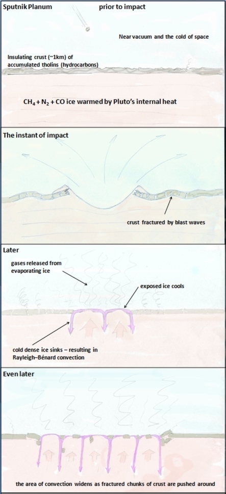 An impact would explain how Pluto can have convection and an atmosphere full of hazes. More HERE
 How Sputnik Planum could have grown from a relatively small impact crater to it's present size.
 This explains the formation of the mountain ranges along Sputnik Planum's shore. Details HERE.
Judging by the slabs deposited in al-Idrisi Montes the thickness of Sputnik Planum's previous crust has turned out to be ~5 km, rather than the ~1 km guess-timate in the schematic.
Rather than an impact, the crust under Sputnik Planum might have cracked up through entirely internal geological processes due to a slow build up of heat under an insulating crust. This would be something like the scenario that has been proposed for Venus, where large sections of its crust get recycled in massive episodes of volcanism after a long periods of relative quiescence during which internal heat builds up. Because it doesn't need a lucky impact this sort of slow cycle scenario might be a more plausible explanation for Pluto's activity.
Nafnlaus
Sep 27 2015, 07:02 PM
QUOTE (Charles Astro @ Sep 26 2015, 06:19 PM)
One possible trigger for the formation of Sputnik Planum could have been an impact at a location where Pluto's crust happened to be relatively thin. Some areas of Pluto do have quite big craters. The crust must be thicker there. You can find a schematic illustration of an impact formation scenario
HERE and how Sputnik Planum could have grown to it's present size
HERE.Judging by the slabs deposited in al-Idrisi Montes the thickness of Sputnik Planum's previous crust has turned out to be ~5 km, rather than the ~1 km guess-timate in the schematic.
Rather than an impact, the crust under Sputnik Planum might have cracked up through entirely internal geological processes due to a slow build up of heat under an insulating crust. This would be something like the scenario that has been proposed for Venus, where large sections of its crust get recycled in massive episodes of volcanism after a long periods of relative quiescence during which internal heat builds up. Because it doesn't need a lucky impact this sort of slow cycle scenario might be a more plausible explanation for Pluto's activity.
Do you think it's just a coincidence that Sputnik is exactly opposite Charon?
JRehling
Sep 27 2015, 07:38 PM
The Moon settled into a tidally locked orientation where the thinnest crust was exactly opposite the Earth; consequently, the overwhelming majority of maria are on the Earth-facing side, clustered around the sub-Earth point. As I understand it, this could equally well have turned out the opposite, with the thinnest crust centered at the anti-Earth point, for reasons similar to those why we have two high tides each day on Earth, with one facing the Moon and one opposite.
Consequently, the thinnest part of Pluto's crust "should" be either at the sub-Charon point or the anti-Charon point. So it's a pretty good conjecture that Tombaugh and Sputnik are at the anti-Charon point because that's where the thinnest crust settled. But it's still a conjecture.
Charles Astro
Sep 27 2015, 09:46 PM
QUOTE (Nafnlaus @ Sep 27 2015, 12:02 PM)
Do you think it's just a coincidence that Sputnik is exactly opposite Charon?
I agree with JRehling, the location of Sputnik Planum is probably no coincidence. Though that may not help to decide between impact or internal volcanism triggered formation of Sputnik Planum.
If the shape of Pluto were prolate, tidal forces should cause the long axis to align with Charon. The same thing happens if Plutos crust is more massive (or surface layers) on one side because, if I understand correctly, that would cause an offset between Plutos center of mass and the center of mass of its core, which effectively gives it a long axis.
At first sight, the location of Sputnik Planum opposite Charon suggests an internal volcanic origin because the crust there was likely to have been thinnest and therefore most likely to give way to a slow build up of internal stresses. On the other hand, if Sputnik Planun was originally covered with crust of fairly common thickness which was hit and broken up due to a cosmic impact, when the broken crust was swept away and ice came flooding up from underneath the mass distribution of Plutos surface layer would have changed. Tidal forces would then tend to move Sputnik Planum to a point on the Pluto-Charon axis, no matter what latitude and longitude it started at.
If Pluto has a planet-wide ocean of soft ice under its solid crust this would make the tidal reorientation all the easier since the crust could easily slide with respect to the core and energy could easily be dissipated, so that Pluto could quickly stop rocking side to side after the reorientation.
The since the crust appears to float on an ocean of Sputnik Planum ice this means that the Sputnik Planum ice is denser than the crust. So might that mean that Sputnik Planum is now a mass concentration on Plutos surface. But then again, the elevation of Sputnik Planum seems to be lower than the surrounding crust so density differences might balance out. Exactly how the soft ice of a global ocean under a thin crust would redistribute itself after Sputnik Planum was opened up seems quite complicated. Perhaps its a good topic for some numerical simulations.
dvandorn
Sep 29 2015, 03:24 PM
I will bring this over here, since it's rather speculative. I've made a mention of the concept in the primary thread, but this gets even more speculative.
I'm thinking that we're seeing actual plate tectonics on Pluto. The plates appear to be smaller and more irregular than we see here on Earth, but it seems that the whole Tombaugh Regio may be the equivalent of seafloor spread, pushing plates of water ice away from it. This would mean that all of those fold-edge chasms we see are actually subduction trenches, where the water ice crust is being forced back underneath the surface, into a "molten" (or at least plastic) mantle composed of similar materials to what we see spreading out onto the surface at, say, Sputnik Planum. The plate movement, and plate collisions, could also account for the raising of the water ice mountains.
The snakeskin terrain could reflect surficial folding from the pressure of plates being shoved along and into each other.
What do you think?
-the other Doug
alan
Sep 29 2015, 09:57 PM
Interesting idea, perhaps the wrinkles to the SE of Norgay Montes have a smaller scale because the crust is thinner there.
On another note, I've been wondering if this area was once another version of Sputnik Planum, with its own chaos terrain at the
east west edge.
Click to view attachment
Nafnlaus
Sep 29 2015, 11:17 PM
QUOTE (dvandorn @ Sep 29 2015, 03:24 PM)
I will bring this over here, since it's rather speculative. I've made a mention of the concept in the primary thread, but this gets even more speculative.
I'm thinking that we're seeing actual plate tectonics on Pluto. The plates appear to be smaller and more irregular than we see here on Earth, but it seems that the whole Tombaugh Regio may be the equivalent of seafloor spread, pushing plates of water ice away from it. This would mean that all of those fold-edge chasms we see are actually subduction trenches, where the water ice crust is being forced back underneath the surface, into a "molten" (or at least plastic) mantle composed of similar materials to what we see spreading out onto the surface at, say, Sputnik Planum. The plate movement, and plate collisions, could also account for the raising of the water ice mountains.
The snakeskin terrain could reflect surficial folding from the pressure of plates being shoved along and into each other.
What do you think?
-the other Doug
Why would water ice subduct on Pluto into nitrogen ice? "Cold", rocky crust on Earth can be denser than the mantle underneath it (when under the same pressure), so subduction makes sense. How does it make sense on Pluto? Why would it go down? Any water ice that reaches the surface should never leave the surface.
Not disagreeing about plate tectonics, just about subduction zones. Trenches have many explanations, the most obvious being that they're grabens.
dvandorn
Sep 30 2015, 03:14 PM
My understanding, from reading a variety of speculations about Pluto's internal structure, is that water ice is lighter than some nitrogen ices, heavier than others, and heavier than liquid nitrogen. So perhaps water ice is subducting into zones where it is indeed heavier than the mantling material. And, of course, the mantling material may not be pure nitrogen ices or pure liquid nitrogen, there may be other solid/liquid/slushy gasses mixed in which could affect the density of a given mantling zone. Remember that some light granitic "float" material on Earth ends up being subducted in some places, along with the heavier, highly hydrated seafloor material. It's not a black-and-white kind of thing.
Also, crustal spread requires either crustal pile-up at plate boundaries or sliding some crustal plates underneath other crustal plates. Some subduction, in terms of plates sliding on top of one another, will occur from mechanical forces alone.
-the other Doug
Nafnlaus
Oct 1 2015, 11:04 PM
What form of nitrogen ice are you envisioning that is less dense than water ice (whether we're talking Ic, Ih, or XI - probably the latter)?
While there seems to be a general consensus that the material we can see exposed at Sputnik is far from "pure" nitrogen ice - it's contaminated by both methane and carbon monoxide ice - there also seems to be a general consensus that it's predominantly nitrogen ice. It wouldn't make sense if it wasn't, anyway - we'd surely see relevant quantities of those contaminants in Pluto's atmosphere and condensed on the surface, as they sublimate quite readily as well (there are of course different rates of loss to escape and photochemical reactions between different chemicals).
It should also be noted that carbon monoxide ice is also heavier than water ice.
Faults leading to canyons can occur due to contraction or expansion. They do not require subduction, and subduction doesn't require the movement of water ice to below nitrogen ice (only water ice under water ice). Tension-induced faulting doesn't even require any sort of "pile-up" - the planet can literally change size (due to thermal expansion/contraction or loss of material to space). In terms of contraction, Pluto loses somewhere on the order of 130kg/s of nitrogen to space - equating to several kilometers of depth over geological timeperiods.
Nafnlaus
Oct 3 2015, 12:19 AM
Thoughts on the Charon "mountain in a moat". First, a few observations: while it's the most pronounced one, there's actually quite a few such shapes on Charon - some with multiple mountains per moat. These exist in (according to the NASA flyover video) in a relatively flat plains (Charon's south), at least with contrast to the north. The south is clearly old-ish, given by the cratering, but seems to lack any large, deep craters - either never having been hit, or flowing in and hiding them well. It also has that randomly-trenched look similar to what one finds on other solar system bodies involving a relatively thin water ice crust over a material that can flow.
Now, for the hypothesis: what we're seeing on Pluto around Sputnik could have been carried out in Charon's past - the potential of mountain-sized water ice chunks "floating" on a nitrogen mantle-sea. Being a smaller body, it "aged" quicker, managing to more quickly ice over its entire surface with water ice. This froze any "floating mountains" in place. The nitrogen mantle-sea however would still exist under the ice, and some nitrogen would still seep out through cracks, requiring settling of the ice crust. What would happen? The ice over it wouldn't settle uniformly - rather, anywhere that the ice is thicker and heavier would sink more than where it's lighter. Aka, where there's a big mountain-sized chunk of it. The nitrogen-ice mantle would flow to redistribute the pressure as needed.
It's somewhat akin to taking a stick of room-temperature butter, putting a sheet of paper over it, and setting a marble on the sheet. The paper "crust" doesn't want to shear all the way through (it's clearly thick, at least at present - no punchthroughs, Charon's gravity is weak, and cryogenic water ice is very hard), but over time it will deform or give via numerous small fractures. The butter "mantle" beneath redistributes the stresses, and the marble "mountain" sinks into its own moat. Charon's northern hemisphere, which its apparently thicker crust, is more like setting a piece of cardboard on the butter. It's just too much resistance to allow localized sagging.
Anyway, just a possibility.
Another variant would be that Charon fully lost a nitrogen ice mantle, draping the ice crust over the next layer down. If, for example, in the past an impact had ripped a crater all the way down through the nitrogen ice mantle to the next layer down, the surface ice crust would be draped across this gash when the nitrogen ice disappeared, causing a localized sag. This would occur regardless of what the shape of the surface ice was.
HSchirmer
Oct 3 2015, 02:30 PM
QUOTE (Nafnlaus @ Oct 3 2015, 01:19 AM)
Thoughts on the Charon "mountain in a moat".
...
Now, for the hypothesis: ...
- the potential of mountain-sized water ice chunks "floating" on a nitrogen mantle-sea.
Well, if Charon has an occasional layer of N2 ices, (IIRC P&C warm and cool over a processional cycle of several million years) then Charon could be something like Mars, glaciers buried under an insulating layer, H20 "dust" covering N2 glaciers. If the mountain is sticking up through the glacier, over time the mountain heats up
and drives off the buried glacier.
Also, "mountain in a moat" is a form we see in melting snowpacks on earth.
A lone column of H2O ice standing in a crater of H2O snow.
http://snobear.colorado.edu/Markw/Research/rills.pdfOn earth, a bit of dark material on snow can trigger ice under the dark material, not melting.
Heat transfer in a freezing/thawing snowpack creates a column of ice in a depression in the snow.
The ice has high thermal inertial and good heat conduction to the cold ground below.
The surrounding snow has low thermal inertia and poor conduction to the cold ground.
The snow melts, and feeds the ice tower.
On Charon, I suspect we are seeing a similar heat flow generated feature.
A crystalline H20 mountain which is in contact with "bedrock" and conducting internal heat up
through a less conductive ice layer.
HSchirmer
Oct 5 2015, 04:20 PM
QUOTE (Steve G @ Oct 5 2015, 05:41 AM)
It almost looks like this island broke apart from the mainland, was carried off and then listed in the Great Melt of the southern hemisphere.
Note how some of the parts fit, similar to South America and Africa.
Not sure it's a clean fit, and it could also be a fissure where both edges erode back from the newly exposed surface.
Thinking about "new surface" it helps to understand just how much mass transfer could occur on P&C.
Pluto and Charon flip poles on a 3 to 3.7 Myr cycle.
Solar System Ices: Based on Reviews Presented at the International SymposiumPublished estimates suggest that the ~3 Myr cycle could drive 1.5 km of ice from pole to pole on Pluto. That suggests that it is possible to move a substantial amount of mass from pole to pole on Charon as well.
Nafnlaus
Oct 6 2015, 09:29 AM
QUOTE (HSchirmer @ Oct 5 2015, 03:20 PM)
That's based on the concept of 1,5km of polar ice cap building up and changing hemispheres. Pluto clearly has no polar ice cap.
QUOTE
I suspect that it is not so much a fracture and a drift as it is a landslide feature.
Has anyone yet done any sort of photogrammetry work to get a sense of what the heights involved are? E.g. if both are roughly equal height then that would strongly suggest drift, while if the southern piece is significantly lower than the northern than that would strongly suggest landslide. It seems to me altitude change is really the only significant distinction between the two - even if it's slid downward, to remain so intact would suggest some sort of effectively fluidized layer underneath it. And even if it was drift, that doesn't mean "drifting on a liquid", objects can drift on flowing solids as well.
Nafnlaus
Oct 6 2015, 10:02 AM
I'm surprised that nobody has commented about how the land just north of this area appears to be a sort of horst-graben terrain, as if many chunks had attempted to shear off but not separated completely. So within the context of the terrain, does the "landslide" hypothesis make sense for all of them? As horst-graben terrain is created by tensile forces drawing the land apart, would it not stand to reason that whatever was dragging it apart was also dragging the "island"? Could Charon's weak gravity actually impart such tensile forces over such a broad area just from a mere height difference?
Something built very dramatic terrain on the surface of Charon - a highly rugged northern hemisphere, and a strangely flat southern hemisphere interrupted by undulating fossae. Assuming a gravity-induced slide suggests that this is part of a post-tectonic relaxation of Charon's surface toward gravitational equipotential. But can we assume that this occurred only after the terrain-building processes, and not as part of it? Certainly there exist craters in the gap between the "island" and the "mainland", at least in its northern portion, so it can't be too young. The broad, flat southern plains also bear small ridges along the same ridging direction, but fractured at a much smaller scale.
ngunn
Oct 6 2015, 10:06 AM
If I'm reading the source right the precession of the rotation axis happens anyway due to the effect of the Sun's gravity. Long term migration of volatiles is mentioned merely as a possible consequence of ithat precession provided suitable materials are present.
HSchirmer
Oct 6 2015, 12:51 PM
QUOTE (Nafnlaus @ Oct 6 2015, 09:29 AM)
That's based on the concept of 1,5km of polar ice cap building up and changing hemispheres. Pluto clearly has no polar ice cap.
Well, clear is the operative word
QUOTE
We just learned that in the north polar cap, methane ice is diluted in a thick, transparent slab of nitrogen ice resulting in strong absorption of infrared light, said New Horizons co-investigator Will Grundy, Lowell Observatory, Flagstaff, Arizona.
Nafnlaus
Oct 6 2015, 05:25 PM
I'm staring at images of Pluto right now, there clearly is no 1,5km thick north polar ice cap. There's mountains and sharply defined craters. Nitrogen ices are well known to not be able to sustain sharp topographic relief at Pluto temperature and gravity conditions (I've run into this mentioned in many different papers discussing Pluto during the leadup to the flyby - it was widely discussed that if sharp topographic relief was found at Pluto that it'd have to be water ice)
That statement was accompanying a low res Ralph image taken during the approach phase. Surely they're talking about something vastly less significant - for example Mars is said to have a seasonal north polar dry ice cap, even though it never gets any thicker than 1m - and the south polar cap 8m. But regardless, there is sharp relief, and thus there's not a 1,5km thick layer of nitrogen ice.
HSchirmer
Oct 7 2015, 04:13 PM
QUOTE (Nafnlaus @ Oct 6 2015, 06:25 PM)
That statement was accompanying a low res Ralph image taken during the approach phase.
...
But regardless, there is sharp relief, and thus there's not a 1,5km thick layer of nitrogen ice.
Ok, seems like two ideas going -
As I understand it, right now, there is N2 ice, mixed with CH4 and some CO, which is basically, all over Pluto, doesn't seem to be any information yet about Charon. In the current orbit, P&C perihelion occurs during equinox, and over the current 248 year orbit, the change in insolation at the poles should be enought to shift eh, less than a meter of N2 ice around on Pluto.
However, Pluto & Charon have a 3+ million year cycle where the poles flip, and you have very different epochs of heating. Right now, perihelion occures at equinox, so the heat is spread out by the 6 day rotation. But, there are epochs where P&C experience perihelion during solstice, and the poles get broiled for 40 years where the sun never sets. That 3 million year cycle has enough difference in insolation to potentially shift kilometers of ice from pole to pole.
QUOTE (Nafnlaus @ Oct 6 2015, 12:25 PM)
I'm staring at images of Pluto right now, there clearly is no 1,5km thick north polar ice cap. There's mountains and sharply defined craters. Nitrogen ices are well known to not be able to sustain sharp topographic relief at Pluto temperature and gravity conditions (I've run into this mentioned in many different papers discussing Pluto during the leadup to the flyby - it was widely discussed that if sharp topographic relief was found at Pluto that it'd have to be water ice)
That statement was accompanying a low res Ralph image taken during the approach phase. Surely they're talking about something vastly less significant - for example Mars is said to have a seasonal north polar dry ice cap, even though it never gets any thicker than 1m - and the south polar cap 8m. But regardless, there is sharp relief, and thus there's not a 1,5km thick layer of nitrogen ice.
That's the thickness of the CO2 ice. Water ice thickness at Martian south pole is 3 kms. I'm looking at a pic of the Martian South Polar cap. How can you tell the thickness from just eye-balling an image? Unless you have an oblique very high res shot of cliffs or an escarpment for reference, I think it is very hard to tell what the depths of any putative ice cap is just by looking at it.
Nafnlaus
Oct 8 2015, 08:38 AM
QUOTE (FOV @ Oct 7 2015, 07:36 PM)
That's the thickness of the CO2 ice. Water ice thickness at Martian south pole is 3 kms. I'm looking at a pic of the Martian South Polar cap. How can you tell the thickness from just eye-balling an image? Unless you have an oblique very high res shot of cliffs or an escarpment for reference, I think it is very hard to tell what the depths of any putative ice cap is just by looking at it.
According to every paper I've read discussing nitrogen ice at Pluto, you *can* get a rough idea of the thickness by eyeballing it because nitrogen ice doesn't support significant topographic relief at Pluto temperatures and gravity. If you can see significant topographic relief, the landscape is built by water ice, not nitrogen ice.
I mentioned Mars's CO2 only in the context of the fact that the CO2 is still referred to as an "ice cap", even though it's transient and thin.
Bill Harris
Oct 14 2015, 05:04 AM
Here is one of my "what-if armwaving scenarios" for a couple of conundrumish features on Charon. Just fitting puzzle-pieces and seeing what fits, so I've not gone bonkers. Yet.
There is the "Mordor" macula near the north pole. Appears to be a reddish-floored depression with some reddish deposit around it, much like an ejecta blanket made of tholins. What I'll assume is that there was an impact or a low-yield explosion which created a shallow crater or caldera. Some of the larger ejecta chunks were tossed out at low velocity and under Charon's low gravity were gently plopped down on the deposits of "Vulcan" planum, thereby creating a moat with a chunk sitting in it. Some chunks may have been more volatile and sublimated away leaving just a depression.
Charon is such a strange place that severe arm waving may be needed.
http://advrider.com/styles/advrider_smilies/y0!.gif--Bill
Bill Harris
Oct 15 2015, 11:29 PM
In Science Magazine:
The Pluto system: Initial results from its exploration by New Horizonshttp://www.sciencemag.org/content/350/6258/aad1815.fullPage 6:
QUOTE
Charon mapping data...received to date reveal a complex geology characterized by numerous bright and dark spots, abundant fault scarps and darker curvilinear markings, both cratered and smooth plains, an extensive system of faults and graben, and a broad and prominent dark area centered on the north pole.
The dark polar spot, called Mordor Macula, is the most prominent albedo marking seen on Charon. This quasi-circular feature has a dark inner zone ~275 km across... Its less dark outer zone is ~450 km across and fades gradually onto higher-albedocratered plains. The inner zone of the dark spot is partly defined by a curvilinear marking that
may be either a ridge or an exposed fault, indicatingthat this feature may be due to a large impact or complex tectonic structure, and suggests the possibility of a compositionally heterogeneous substrate.
--Bill
HSchirmer
Dec 7 2015, 03:05 AM
QUOTE (Bill Harris @ Dec 6 2015, 10:20 AM)
...
Good analogy. WaterIce-ite has an SG of 0.927 and Nitrogen an SG of 1.026 so the debris might tend to be somewhat "floaty".
...
I just realized something.
If sputnik planum DOES turn out to be an expanse of 10k deep convection cells of soft nitrogen ice- -
then sputnik planum is probably the most important sample return site in the solar system.
Not the N2 ice itself, but because that area of Pluto should be the best meteor collection site in the solar system.
It ought to be essentially similar to the Alan Hills area of antartica, where meteoroids impact on a (relatively) soft surface,
they are sealed in seasonal ice, and the conveyor belt action of the ice has an opportunity to concentrate them.
JRehling
Dec 7 2015, 10:42 PM
QUOTE (HSchirmer @ Dec 6 2015, 08:05 PM)
Not the N2 ice itself, but because that area of Pluto should be the best meteor collection site in the solar system.
The delta-v for a sample return from Pluto in a reasonable time frame (<30 years) would be ridiculous, not even counting the requirements for sample collection. Three huge impulses (> 15 km/sec) would be required, for a total of about 50 km/sec. This is far beyond any mission yet launched.
Meteorites landing on Earth are slowed by our atmosphere first, as opposed to hitting a solid surface. A "soft" solid surface is a lot harder than air.
Collecting meteorites from Pluto is one of the least efficient and least feasible space exploration ideas I've heard of. We could collect them directly from asteroids, not to mention Antarctica, enormously faster and cheaper.
HSchirmer
Dec 8 2015, 04:54 AM
Hmm, good points I hadn't considered, good to check on a gedankenexperiment.
QUOTE (JRehling @ Dec 7 2015, 10:42 PM)
Meteorites landing on Earth are slowed by our atmosphere first, as opposed to hitting a solid surface.
But they have also been accelerated by the gravity well of the sun and the local gravity well of earth. That requirement for "huge impulses" of 15 km / sec, can be a double edged sword.
The reason for that huge ▲V to get out to Pluto in the first place is climbing out a gravity well,
which is what helps impart that destructive velocity in the first place.
QUOTE (JRehling @ Dec 7 2015, 10:42 PM)
A "soft" solid surface is a lot harder than air.
Agreed. But is snow solid? is a box of styrofoam packing peanuts sollid?
If Sputnik is filled with convecting N2 ice, then by definition that isn't solid.
Think of a 10km deep sea of circulating nitrogen snow.
QUOTE
HEAT_AND_MASS_TRANSPORT_IN_NITROGEN_ICE_WITH_APPLICATION_TO_PLUTO_AND_TRITON
http://www.researchgate.net/publication/25...LUTO_AND_TRITONHence, the estimate for the maximum grain size of ~ 1 cm, which we have obtained for Triton (Duxbury and Brown 1997) can be applied and even reduced for Pluto. This makes the solid-state subsurface convection in perennial N2 deposits more probable on Pluto than on Triton
Sorry, I should have emphasized that "solid" is more about "solid state" than slab-solid.
QUOTE (JRehling @ Dec 7 2015, 10:42 PM)
Collecting meteorites from Pluto is one of the least efficient and least feasible space exploration ideas I've heard of.
We could collect them directly from asteroids, not to mention Antarctica, enormously faster and cheaper.
Sorry, I should have emphasized the benefit of collecting primordial dust, micrometeroids, and meteoroids from the Kuiper belt, oort cloud, or passing stars.
Now that you mention it, I see that it would be better to do sample analysis out in the cold.
We can't collect samples of interesting ices from earth or asteroids, because they simply boil away.
Could do that at Pluto.
I might also mention, if Sputnik IS a sea of convecting nitrogen snow crystals, then it should have
seasonal layers as well - not unlike the greenland ice cores we rely on to check for climate change.
Except that a circulating glacier would store the history of the solar system's climate-.
JRehling
Dec 8 2015, 08:02 PM
To sample stuff from the outer solar system, I'd spend my money on intercepting a long-period comet or a comet on a hyperbolic trajectory before it enters the inner solar system. That would be a lot cheaper and faster than a round-trip to Pluto and back.