Full Version: Last stops around Victoria, before the Long Trek
Let's use this topic for the last stops (Cabo Frio, perhaps?) before Opportunity leave the vicinity of Victoria for good.
This is a guess, but I'm pretty sure we'll stop at Cabo Frio before leaving. Paolo?
QUOTE (Tesheiner @ Sep 27 2008, 02:48 AM) 
This is a guess, but I'm pretty sure we'll stop at Cabo Frio before leaving. Paolo?
I hope not. Today's plan is somewhat more ambitious. I don't want to jinx it, I have a few more hours to wait. I will keep you posted.
Paolo
Well that's intriguing 
Seems like a long time since we've seen drive-direction mosaics like this:
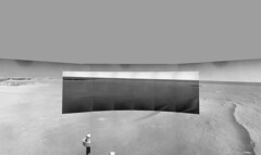
Looking south, even... it brings a smile to my face.
Seems like a long time since we've seen drive-direction mosaics like this:
Looking south, even... it brings a smile to my face.
Here is a Sol 1661 QTVR (2.1MB), just because the scene is so beautiful.
QUOTE (RoverDriver @ Sep 27 2008, 03:04 PM)
Today's plan is somewhat more ambitious.
I wonder if "Last stops around Victoria, before the Long Trek" is destined to be a very short thread.
QUOTE (mhoward @ Sep 27 2008, 08:38 PM)
the scene is so beautiful.
It sure is - and thanks very much for making it so real for us. An emotional moment, it reminds me of our first glimpse in.
Enjoy the scenery while it lasts, kids, we're about to start driving across Kansas!
QUOTE (centsworth_II @ Sep 27 2008, 09:41 PM)
I wonder if "Last stops around Victoria, before the Long Trek" is destined to be a very short thread.
This idea crossed my mind at the right moment I opened the thread.
 Then I said "no way, Cabo Frio is a mandatory stop!", but now after Paolo's comments I'm not sure of anything. Will we see one of those 100m drives today?
That is indeed beautiful, and thank you for the gift, MH.
Inspiring as well, and for those who don't care for poetry, my apologies in advance:
Leaving Victoria
The horizon has never been featureless
and now we must leave the layers
of the mysterious past, for our limitations stop us now
but only now
for all life is short, and we must leave.
This alien place, this new home
must be seen, must be touched as much as possible
and the distant cliffs beckon, there is no resistance
Victoria gives us up willingly, for we are strangers still
Onward, for as long as we can
Onward, through dunes and cold and penetrating frosty dust
Onward, past cobbles and meteorites
Onward, till the power is gone, and our vision grows dim...
Someday we will stand static and alone, but not forever
and never now
we go onward, and see what must be seen
we go
now
What is it with all these poets? Well, if they can do it so can I.
There once was a rover called Oppy,
Whose aiming once got a bit sloppy.
Things got rather gory
Inside Purgatory,
But now she is driving non-stoppy.
Philliam Shakespeare
There once was a rover called Oppy,
Whose aiming once got a bit sloppy.
Things got rather gory
Inside Purgatory,
But now she is driving non-stoppy.
Philliam Shakespeare
...LOVE it!!!!(BTW, Phil, still waiting on that damn mascot job to open up for your school...I've switched to even cheaper cigars!!!)
4,245,000 bottles of beer on the wall...4,245,000 bottles of beer...
QUOTE (Tesheiner @ Sep 27 2008, 01:10 PM)
This idea crossed my mind at the right moment I opened the thread. Then I said "no way, Cabo Frio is a mandatory stop!", but now after Paolo's comments I'm not sure of anything. Will we see one of those 100m drives today?
Then I said "no way, Cabo Frio is a mandatory stop!", but now after Paolo's comments I'm not sure of anything. Will we see one of those 100m drives today?Not really. Almost 153 meters straight south. Don't be alarmed, there will be no imaging today, we'll have to wait one more day to get them. One of the tricks we will probably use during this adventure.
Paolo
there once was a rover, quite clever
who was in Victoria forever
then one day she popped out
and aligned to the south
for Squires had said...Endeavour!
QUOTE (RoverDriver @ Sep 28 2008, 02:40 AM)
Almost 153 meters straight south.
Oh boy!

Should I change the thread's name to "Running around Victoria before the Long Trek"?
QUOTE (RoverDriver @ Sep 28 2008, 01:40 AM)
One of the tricks we will probably use during this adventure.
Ahhh ( going onto guess mode )
Driving limited perhaps by time rather than power - so if you forgo the imaging at the end of the drive before stopping for the PM UHF pass, you can get more drive time into the schedule.
Do this when on restricted sols and you can pre-estimate Sol N+2's drive from engineering and HiRISE - and give it a go/no go when you get the post drive imaging on Sol N+1
Just guessing
Doug
Wow, you are so good! Your first guess is 100% correct. The second is currently incorrect. Before we move the rover there is minimum set o data we need to receive before we are allowed to drive again. Front and Rear Hazcams is one of these products. Therefore this trick can only be currently applied on weekends.
We are trying to relax the risk posture, but it will take time to understand what we can relax and still maintain the vehicle safe. This drive had one component that was relaxed which I think it will be accepted. I'm sure we will need to come up with many tricks to get to Endeavour before the juice runs out.
Paolo
Paolo, given the relative safety of the current driving surface, have you considered going for a new single drive record, which I believe is currently 220 meters?
QUOTE (RoverDriver @ Sep 28 2008, 02:27 PM)
Therefore this trick can only be currently applied on weekends.
That was my guess.
QUOTE (BrianL @ Sep 28 2008, 08:17 AM)
Paolo, given the relative safety of the current driving surface, have you considered going for a new single drive record, which I believe is currently 220 meters?
I'm sure all rover drivers are thinking about it
but (I hope) we are disciplined enough to think about the goal which is not beating the record but to get to Endeavour.Paolo
I agree with you Tescheiner. I think it would be fun going around Victoria but we do need to start
our journey South.
What areas along the West side or Southern part of Victoria might be good places to go to and
what area south of Victoria should we stop at to explore??? First targets?
our journey South.
What areas along the West side or Southern part of Victoria might be good places to go to and
what area south of Victoria should we stop at to explore??? First targets?
QUOTE (Bobby @ Sep 28 2008, 02:32 PM)
I agree with you Tescheiner. I think it would be fun going around Victoria but we do need to start
our journey South.
What areas along the West side or Southern part of Victoria might be good places to go to and
what area south of Victoria should we stop at to explore??? First targets?
our journey South.
What areas along the West side or Southern part of Victoria might be good places to go to and
what area south of Victoria should we stop at to explore??? First targets?
We have received indicaions for a couple of spots in VC rim in the west and SW. The first stopover is about 150-200m SE of where the rover currently is. The next stopover is about 300m SE of the first stop. After these two locations, I have no indications whether there will be additional stops or is we are fre to leave VC.
Paolo
Thanks Paolo for the information.
Since I'm not into drawing overhead shots of Victoria.
I hope one of our computer drawing guru's in here might determine
which area of Victoria is the 1rst target Paola said is 150 to 200 meters SE
of our current location and the 2nd target which is 300 meters SE of where
we are?

Since I'm not into drawing overhead shots of Victoria.
I hope one of our computer drawing guru's in here might determine
which area of Victoria is the 1rst target Paola said is 150 to 200 meters SE
of our current location and the 2nd target which is 300 meters SE of where
we are?
This is like a treasure hunt or playing "Where's Opportunity?" ... head south 153m, then southeast for 150-200m and find a target southeast 300m of your first position.
OK, so without taking a massive leap across an unnamed 'bay', I guess that with a few turns we'd end up somewhere here (?)
Any location along this part of VC will produce great views (oh, and of course 'great science').
I'd especially like a view across that large slumped area. Plus the view back along VC to Duck Bay will be spectacular!
Anywhere really....Go Oppy!
Click to view attachment
Astro0
... head south 153m, then southeast for 150-200m and find a target southeast 300m of your first position.OK, so without taking a massive leap across an unnamed 'bay', I guess that with a few turns we'd end up somewhere here (?)
Any location along this part of VC will produce great views (oh, and of course 'great science').
I'd especially like a view across that large slumped area. Plus the view back along VC to Duck Bay will be spectacular!
Anywhere really....Go Oppy!
Click to view attachment
Astro0
Astro0, I took Paolo's comments to mean:
Go 150-200 m and stop.
Go 300 m beyond that and stop.
Paolo?
Go 150-200 m and stop.
Go 300 m beyond that and stop.
Paolo?
QUOTE (Astro0 @ Sep 28 2008, 03:50 PM)
This is like a treasure hunt or playing "Where's Opportunity?" ... head south 153m, then southeast for 150-200m and find a target southeast 300m of your first position.
OK, so without taking a massive leap across an unnamed 'bay', I guess that with a few turns we'd end up somewhere here (?)
Any location along this part of VC will produce great views (oh, and of course 'great science').
I'd especially like a view across that large slumped area. Plus the view back along VC to Duck Bay will be spectacular!
Anywhere really....Go Oppy!
Click to view attachment
Astro0
... head south 153m, then southeast for 150-200m and find a target southeast 300m of your first position.OK, so without taking a massive leap across an unnamed 'bay', I guess that with a few turns we'd end up somewhere here (?)
Any location along this part of VC will produce great views (oh, and of course 'great science').
I'd especially like a view across that large slumped area. Plus the view back along VC to Duck Bay will be spectacular!
Anywhere really....Go Oppy!
Click to view attachment
Astro0
I apologize if I gave the wrong distances, I was roughly quoting from memory. On the image above, the end of your tracks are exactly at the second (and last) imaging location at VC. The first location is at the edge of the rim just above the 150 marker.
Paolo
Thanks Paolo.
I thought my guess might be right.
My "inner explorer" told me that this particular cape would be a good science-stop and would be the last(?) stop on Oppy's VC journey.
Bring on the trek to Endeavour....we're with you ALL the way.
Astro0
I thought my guess might be right.
My "inner explorer" told me that this particular cape would be a good science-stop and would be the last(?) stop on Oppy's VC journey.
Bring on the trek to Endeavour....we're with you ALL the way.
Astro0
QUOTE (Astro0 @ Sep 28 2008, 05:42 PM)
Let's say it's 200m SE and then another 300m SE, then anywhere along these two lines and yellow arcs could be the destinations.
I'd be really surprised if they would do a 150 meter drive that close to the edge of the crater. Paolo? What are the rules?
QUOTE (ElkGroveDan @ Sep 28 2008, 06:24 PM)
I'd be really surprised if they would do a 150 meter drive that close to the edge of the crater. Paolo? What are the rules?
There are no rules!
No cops, no "traffic patrolled by aircraft", wait a minute! We are patrolled from above! I better slow down! ;-)Seriously, the tracks Astro0 posted are way too close to the rim. When we approach a target on a crater we align to the target by staying at a safe distance (a few 10s of meters) then dedicate one or two drives to the approach depending on how critical the position is and how close to the rim we need to be. This might mean a longer route, but quicker. And as everyone who has walked the hills of San Francisco has found, the straight line might not be the easiest, quickest, requires less energy or even possible.
Paolo
Paolo - "Seriously, the tracks Astro0 posted are way too close to the rim."
Hey, I didn't say that I knew how to drive but I do know where we are going!
Astro0
Hey, I didn't say that I knew how to drive
but I do know where we are going! Astro0
Good hunch there, EGD.
I'd also suspect that if the second stop on the rim is the last, that afterward, the route would go pretty much directly south from there.
QUOTE (RoverDriver @ Sep 28 2008, 08:10 PM)
... On the image above, the end of your tracks are exactly at the second (and last) imaging location at VC. The first location is at the edge of the rim just above the 150 marker.
hmm...That looks like a good set up to do one more long baseline stereo pair. If so, it would be nice if it could be done in color.I'd also suspect that if the second stop on the rim is the last, that afterward, the route would go pretty much directly south from there.
QUOTE (CosmicRocker @ Sep 28 2008, 07:15 PM)
Good hunch there, EGD.
hmm...That looks like a good set up to do one more long baseline stereo pair. If so, it would be nice if it could be done in color.
I'd also suspect that if the second stop on the rim is the last, that afterward, the route would go pretty much directly south from there.
hmm...That looks like a good set up to do one more long baseline stereo pair. If so, it would be nice if it could be done in color.
I'd also suspect that if the second stop on the rim is the last, that afterward, the route would go pretty much directly south from there.
I haven't heard any mention of superres or WBS on the first target.
Paolo
QUOTE (RoverDriver @ Sep 28 2008, 09:25 PM)
I haven't heard any mention of superres or WBS on the first target.
Yes. But even if it wasn't planned, we will do it, if we can. The database might announce the intentions. I wasn't expecting superres unless something exceptional was noticed.We only need overlapping images from those two locations, and it would seem neglectful to not collect more long distance 3D from the SW corner of the crater before Opportunity leaves. But, what do I know.
QUOTE (djellison @ Sep 28 2008, 11:39 AM)
Driving limited perhaps by time rather than power - so if you forgo the imaging at the end of the drive before stopping for the PM UHF pass, you can get more drive time into the schedule.
More info on this loooong drive: it started around 12:45 and it took 'til 16:30 to cover those 150m with some stops in the way to confirm "all is well". This one hasn't the record in terms of distance, but perhaps it has the record in terms of driving time.
QUOTE (RoverDriver @ Sep 28 2008, 12:07 PM)
(I hope) we are disciplined enough to think about the goal which is not beating the record but to get to Endeavour.
Interesting comment. Perhaps I'm reading too much into it, but it sounds like you are saying that very long drives are not good for the long term mobility of the rover.

QUOTE (BrianL @ Sep 29 2008, 04:06 AM)
Interesting comment. Perhaps I'm reading too much into it, but it sounds like you are saying that very long drives are not good for the long term mobility of the rover.
No, I really mean that while trying to do long drives we still maintain the rover safe. The goal is getting there, not die trying to.
Paolo
QUOTE (BrianL @ Sep 29 2008, 01:06 PM)
Interesting comment. Perhaps I'm reading too much into it, but it sounds like ...
"How far can we go?" not "Can we go more than 220m?"
Doug
Please, excuse my ignorance. Would Oppy need to do a cool down stop if it drove for too long?
(I know, it isn't a F1, but the martian air isn't very conductive either.)
(I know, it isn't a F1, but the martian air isn't very conductive either.)
Dunno.
But what I really know is that our fellow rover (or the driver behind ) is a little bit "drunk".
Check the wheel marks: http://qt.exploratorium.edu/mars/opportuni...23P1312R0M1.JPG
I know, I know! That's deliberately made to ease the work for the autonav (or whatever it's called).
But what I really know is that our fellow rover (or the driver behind
) is a little bit "drunk".Check the wheel marks: http://qt.exploratorium.edu/mars/opportuni...23P1312R0M1.JPG
I know, I know! That's deliberately made to ease the work for the autonav (or whatever it's called).
Drunken sailor walk
I don't think the rover motors would overheat. With 900+Whrs during high summer, the WEB may get to an overheating situation ( as happened at the summit of Husband Hill briefly ) - but the rover motors are so exposed that I find it hard to believe they could get warm to the point of being worrying.
Doug
QUOTE (djellison @ Sep 29 2008, 10:08 PM)
Drunken sailor walk
Doug
Doug
Realy? I thought it was more eratic. Well, last such drive was over 1 year ago and I don't remember very well. I didn't though we'll ever have to use it for real!
Anyway I guess she'll use lot of this technique for quite a while. I intentionnaly say "she" because I guess we can call this "self navigation" as opposed to "ordered navigation".
I don't think this was an example of the drunken sailor walk - but that's what they called it when the rover stopped quite regularly to give autonav / visidom something to see.
Doug
Doug
Are we on a day on/day off schedule for driving now or can we drive everyday?
I would say at the moment we're on restricted sols.
Doug
Doug
New maps at JPL, including some new placenames on Victoria's rim:
http://marsrovers.jpl.nasa.gov/mission/traverse_maps.html
Phil
http://marsrovers.jpl.nasa.gov/mission/traverse_maps.html
Phil
Got some words from SS, on the stops Paolo made reference to, the reason and how much time will Oppy take there?:
"The objective there will be the same as the objective was at our many stops along the northern rim... to image stratigraphy on the opposing cliff faces.
It's hard to predict exactly how long they'll take, but we'll try to get them wrapped up as quickly as possible."
And what about aditional stopovers? Will there be any or are we clear to hit the road after these two?
"You never know... depends on what we find. We're exploring new territory now, and whenever we see something that merits a stop, we'll stop. But we intend to hit the road as soon and as fast as we can."
"hit the road as soon and as fast as we can"
I like the sound of that...
May October show us Journeys like this daily 
QUOTE (Phil Stooke @ Sep 30 2008, 06:17 AM)
New maps at JPL, including some new placenames on Victoria's rim:
http://marsrovers.jpl.nasa.gov/mission/traverse_maps.html
Phil
http://marsrovers.jpl.nasa.gov/mission/traverse_maps.html
Phil
Hi Phil:
Now that we're under way again, and I've got a groovy new tool, I've gone back and corrected all the locations back to the lander. Based on the quality of the overhead projected Navcam pans (at a resolution of 1cm/pixel) and the resolution of the HiRISE mosaic I'm using (25cm/pixel), I can just about "guarantee" the locations are accurate to about a half meter. Next step will be registering the HiRISE mosaic to the Mars control net.
-Tim.
PS: For your perusal Click to view attachment
That's great, Tim - both the new map and the news that the locations are fixed all the way back to the lander.
Will that full location data set end up in PDS at some point?
Phil
Will that full location data set end up in PDS at some point?
Phil
This is a "lo-fi" version of our main content. To view the full version with more information, formatting and images, please click here.