Full Version: Last stops around Victoria, before the Long Trek
Quick anaglyph... not much depth of field I'm afraid... sorry...
Yes, I'll go with Endurance, at least until Tesh shows us on the orbital map. I shouldn't have trusted my memory without checking a map.
Bad! (raps own knuckles)
Bad! (raps own knuckles)
I'm not longer from you side, Shaka.
There's no way on Ear... er, Mars we can see Endurance from where we are. When coming to Victoria, I've understood that the near side was higher than the far side so I guess we are a little bit going down at the moment and Endurance disapeared from view a looong time ago. Let see what the specialists have to say.
There's no way on Ear... er, Mars we can see Endurance from where we are. When coming to Victoria, I've understood that the near side was higher than the far side so I guess we are a little bit going down at the moment and Endurance disapeared from view a looong time ago. Let see what the specialists have to say.
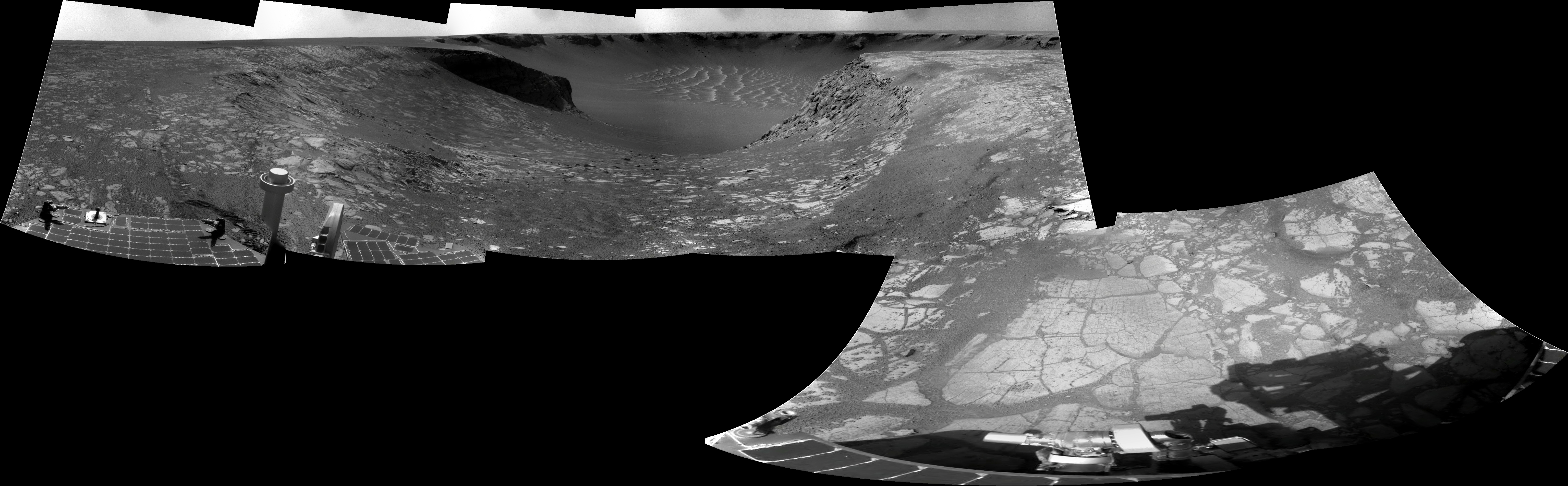
Yes it's true it cannot be the Beacon, on Cape St Mary, which is outside of the frame. But also not Endurance, instead it's one of those hefty drifts at the 'lip' of Duck Bay. In the stitched image you can see several similar but smaller dunes framing the various bays of Victoria. (It's somewhat amazing to me that on Mars the biggest dunes always tend to gather themselves on the highest spots of the local topography.)
QUOTE (marswiggle @ Oct 9 2008, 10:56 PM) 
... instead it's one of those hefty drifts at the 'lip' of Duck Bay.
Exactly.
QUOTE (peter59 @ Oct 9 2008, 10:08 PM)
and Cape Victory
http://qt.exploratorium.edu/mars/opportuni...CUP0605R0M1.JPG
http://qt.exploratorium.edu/mars/opportuni...CUP0605R0M1.JPG
When I saw that picture I said: What the hell!!! Are we going IN again?!?
Must check the latest mobility info but it seems we are on the next cape following Victory. Does it have a name?
Edited: Check the latest map update.

QUOTE (BrianL @ Oct 9 2008, 08:45 PM)
Is that a crater rim sticking above the horizon in the middle frame?
It's the dune that was at the entry to Duck Bay.

Some nice details in the shadows of that Cape.
Click to view attachment
Click to view attachment
It is fascinating to see how differently the new capes appear to us. They are driving very quickly these days. I guess we need to move our eyes southward as we catch a few last glimpses of lovely Victoria.
The view in full res 
It's a very impressive place which is remembers me Valley Without Peril

It's a very impressive place which is remembers me Valley Without Peril
Nice work Ant and Tesh. Here's my shot at this view.
Astro0
Astro0
QuickTime VR version (2.3 MB) of the Sol 1674 view (done using MMB and PTGui). The initial view direction is north.
Do yu think we could see Oppy's path at Ducks bay ?
Actually, Duck's Bay is seen over the tip of the previous Cape in the panorama, right?
Actually, Duck's Bay is seen over the tip of the previous Cape in the panorama, right?
A little hard to have a good result, and I think it's pretty good.
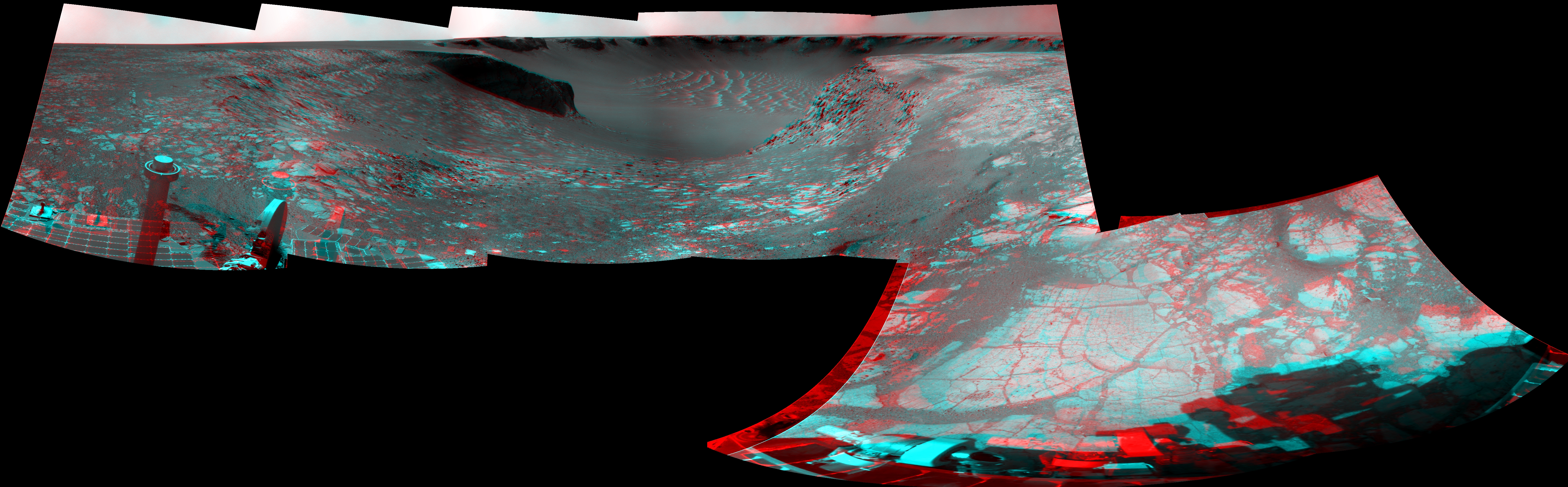
The same pano but in stereo

(Hugin&Gimp )
The same pano but in stereo
(Hugin&Gimp
)
What a spectacular view! Thanks for the pans, guys. What a beautiful spot to say farewell to old Victoria...
Here's an attempt at cleaning up the nice navcam cloud sequence from sol 1669. It's basically each frame divided by the average of all six frames, then tweaked a bit:
Click to view attachment
Here's an attempt at cleaning up the nice navcam cloud sequence from sol 1669. It's basically each frame divided by the average of all six frames, then tweaked a bit:
Click to view attachment
What the heck is that data drop out in the upper corner? The mother ship?
Mother ship, hah!
Actually, if you look at the original jpegs, they all have zero pixel value in that corner. Those jpegs are stretched, so the brightest pixel becomes 255 and the darkest pixel becomes 0. So that corner isn't really black, it's just the darkest part of the navcam frame (and probably not much darker than other parts, really). So when I flatfielded by taking the ratio, I just set 0/0 to black. There will definitely be much more detail in the raw images.
Actually, if you look at the original jpegs, they all have zero pixel value in that corner. Those jpegs are stretched, so the brightest pixel becomes 255 and the darkest pixel becomes 0. So that corner isn't really black, it's just the darkest part of the navcam frame (and probably not much darker than other parts, really). So when I flatfielded by taking the ratio, I just set 0/0 to black. There will definitely be much more detail in the raw images.
Going back a bit, here's the completed Sol 1666 Navcam panorama in QuickTime VR (now 2.7 MB).
I'm crazy about this particular sol 1674 navcam frame. Here's an anaglyph version:
Click to view attachment
Let's soak up the dramatic scenery while we can...
Click to view attachment
Let's soak up the dramatic scenery while we can...
Look at all that bedrock:

Edit: increased the brightness to bring out some detail.
Edit: increased the brightness to bring out some detail.
QUOTE (climber @ Oct 10 2008, 03:33 PM)
Do yu think we could see Oppy's path at Ducks bay ?
Actually, Duck's Bay is seen over the tip of the previous Cape in the panorama, right?
Actually, Duck's Bay is seen over the tip of the previous Cape in the panorama, right?
I think it is visible in that Pancam image http://qt.exploratorium.edu/mars/opportuni...CUP2361L2M2.JPG
I've been getting a little behind worrying about the ripples further south. Just catching up with the last couple of colour mosaics.
Sputnik

And Cape Pillar

(Both images link to the same page)
James
Sputnik
And Cape Pillar
(Both images link to the same page)
James
I could not resist building for you this nice panorama... An impressive view ! Enjoy ! Click to view attachment
Does anyone know when the next drive is?
QUOTE (SFJCody @ Oct 14 2008, 05:50 PM)
Does anyone know when the next drive is?
Today.
1. What new EDRs from ANY sol were received on sol 1679?
Sol Seq.Ver ETH ESF EDN EFF ERP Tot Description
----- -------- --- --- --- --- --- ---- -----------
01679 p0633.03 0 0 0 2 0 2 navcam_3x1_az_54_3_bpp
01679 p1211.03 2 0 0 2 0 4 ultimate_front_haz_1_bpp_pri_15
01679 p1311.07 2 0 0 2 0 4 rear_haz_ultimate_1_bpp_crit15
QUOTE (Tesheiner @ Oct 14 2008, 01:25 PM)
Strange. Not sure why we're suddenly hanging around here, unless maybe it's to take long-baseline stereo of Cape Victory?
And I guess somethings broken in the update process, as Exploratorium doesn't seem to be updating.

Edit: new images down. I guess the pipeline is working after all.
I'd say it is for long baseline imaging.
Unless, of course, they've spotted some festoons!

Unless, of course, they've spotted some festoons!

QUOTE (mhoward @ Oct 14 2008, 09:40 PM)
And I guess somethings broken in the update process, as Exploratorium doesn't seem to be updating.
Edit: new images down. I guess the pipeline is working after all.
Edit: new images down. I guess the pipeline is working after all.
Not completely; the hazcams are still missing and they were downlinked before the available navcams. Images from the previous site are missing too.
Edited: Today's imaging plan includes these mosaics but no driving. I guess the pancam one is for LBS imaging and once finished we'll leave Victoria for good.
01680::p1900::01::2::0::0::2::0::4::nav_2x1_deckCheck_pri61
01680::p1953::02::2::0::0::2::0::4::nav_1x1_az_180_1_bpp_LUT3_pri57
01680::p2364::19::3::0::0::3::1::7::pancam_Victory_3x1_L2
...and once finished we'll leave Victoria for good.
What about having the last look at Sofi ("Explorer") crater ?
I'd love to see a last view of Victoria across Sofi before leaving... and see up close the interface between the rims of Victoria and Sofi with some exposed layers on both sides
Click to view attachment
What about having the last look at Sofi ("Explorer") crater ?
I'd love to see a last view of Victoria across Sofi before leaving... and see up close the interface between the rims of Victoria and Sofi with some exposed layers on both sides
Click to view attachment
In his DPS presentation yesterday, Steve suggested there would be one stop after this one - (C on the attached image) and then we're gone.
QUOTE (vikingmars @ Oct 15 2008, 03:27 AM)
...and once finished we'll leave Victoria for good.
What about having the last look at Sofi ("Explorer") crater ?
I'd love to see a last view of Victoria across Sofi before leaving... and see up close the interface between the rims of Victoria and Sofi with some exposed layers on both sides
Click to view attachment
What about having the last look at Sofi ("Explorer") crater ?
I'd love to see a last view of Victoria across Sofi before leaving... and see up close the interface between the rims of Victoria and Sofi with some exposed layers on both sides
Click to view attachment
I would like to see that as well. It would be interesting to see the impact boundary between the two craters.
Would the boundary be worth it? Obviously Victoria predates Sofi, and the most recent activity appears to be the erosion and cape-and-baying of Victoria, perhaps by 100m diameter. As Sofi has not yet been cut by the advancing erosion, what benefits are likely in studying the smaller crater?
Andy
Andy
I'd like a stop by Sofi as well.
I think it would be really interesting to get a compare/contrast of Sofi vs. Victoria. Especially to see how the impact rim of Sofi is eroding out into Victoria (how fractured is it? Did the Sofi impact compression make the Victoria side erode faster or slower?).
The potential for dramatic pictures is also worthwhile. Neat angles of Sofi in the foreground with Victoria. (I thought the Sputnik crater images were pretty cool.) And you might get a nice shot of Duck Bay (could we see Oppy's tracks?) from across Victoria.
(Is there a wire I can pull to signal a stop?)
-Mike
If we stop every time someone says 'that's interesting' between here and Endeavour - it'll take 2,000 years, not 2.
QUOTE (djellison @ Oct 15 2008, 05:06 PM)
If we stop every time someone says 'that's interesting' between here and Endeavour - it'll take 2,000 years, not 2.
It reminds me :
"133:09:15 Shepard: I don't think we'll have time to go up there."
"133:09:16 Mitchell: Oh, let's give it a whirl. Gee whiz. We can't stop without looking into Cone Crater. (Garbled) everything if we don't get there."
Well... I'm on Mitchell's side !
Cone Crater probably isn't a good example, given that they couldn't really find it and never made it
Put it this way - if I had to make a choice between stop 'C' - and Explorer crater - I would say 'C'. You have to draw a line somewhere, really.
Doug
Put it this way - if I had to make a choice between stop 'C' - and Explorer crater - I would say 'C'. You have to draw a line somewhere, really.
Doug
Oh, we are 100% in back-seat driving mode, aren't we?
Meanwhile, here's Cape Victory as seen by the pancam (L2 filter) "this evening" (sol 1680).
Click to view attachment
Meanwhile, here's Cape Victory as seen by the pancam (L2 filter) "this evening" (sol 1680).
Click to view attachment
QUOTE (Tesheiner @ Oct 15 2008, 09:00 AM)
Meanwhile, here's Cape Victory as seen by the pancam (L2 filter) "this evening" (sol 1680).
Quit teasing us. There's nothing we can do about it now.
QUOTE (ElkGroveDan @ Oct 15 2008, 10:12 AM)
Quit teasing us. There's nothing we can do about it now.
That's life, I guess. I think the incline is too steep, anyway. At least that's what I'm telling myself

This one suffers from all sorts of compressed JPG and brightness stretching issues, but here's the QuickTime VR for Sol 1679 so far (2.9MB)
I've long wondered about access to deep layers via some of the eroded capes, rather than the bays. Look at Capes Victory, Frio, and the "backside" of the Beacon (St. Mary). With the new imagery, I estimate the slope leading down towards the tip of Cape Victory at around 15 to 20 degrees, which on the surface sounds drivable. But some of that slope looks like it might be quite rough.
We have to assume that Duck Bay was deemed either safer or more interesting than these alternatives.
We have to assume that Duck Bay was deemed either safer or more interesting than these alternatives.
Whether or not we'll ever see a closeup view of Explorer from ground, we always have the HiRISE imagery. I don't remember seeing anaglyphs of the southern bays and Exp, so I made one myself. (In full res, using PSP_001414_ and 009141_1780)
I have an impression that the bay nearest to Exp is already in the process of eating into the little crater, and thus its present west rim is not anymore the 'original' one, as revealed by its inward deviation and slight dip from the otherwise nicely symmetrical rim.
Also see the unusually sharp edge of the tip of the cape next to (left of) Explorer.
With apologies to everyone...
Sofi Crater over there...
We're heading into the weekend and here're bits of the imaging plan and how I "read" it:
01682::p0617::08::14::0::0::14::0::28::navcam_7x1_az_18_0.5_bpp
01682::p0713::03::6::0::0::6::0::12::navcam_3x1_az_198_3_bpp
01682::p1211::03::2::0::0::2::0::4::ultimate_front_haz_1_bpp_pri_15
01682::p1311::07::2::0::0::2::0::4::rear_haz_ultimate_1_bpp_crit15
01682::p2365::19::12::0::0::12::2::26::pancam_Cape_Victory_3x1_L257R2
01682::p2366::19::12::0::0::12::2::26::pancam_iceland_L257R1
01682::p2367::19::8::0::0::8::2::18::pancam_drive_dir_4x1_L7R1
01682::p2580::21::19::0::0::19::4::42::pancam_superres_Cape_Victory1_L26R12
01682::p2581::21::19::0::0::19::4::42::pancam_superres_Cape_Victory2_L26R12
01683::p2368::19::4::0::0::4::1::9::pancam_LBS_Cape_Victory_pt2_L2
Sol 1682 (today): Color mosaic of Cape Victory, followed by driving a bit towards the tip of the current cape (BTW, does it have a name?) and taking the usual post-drive nav/pancam mosaics.
Sol 1683 (saturday): Superres and second LBS mosaic of Cape Victory.
Sol 1684 (sunday): Leave the area.
Tesheiner, what might be the "iceland" referred in your post?
Dunno until the images are downlinked. Just wait a few hours.
This is a "lo-fi" version of our main content. To view the full version with more information, formatting and images, please click here.