
Full Version: Let's Get Moving
Going Ballistic!!!
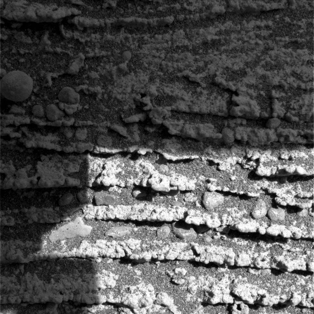
I think they've stopped to do some science observations. The boundary between the light and dark bedrock they were interested in back at Burns Cliff is probably accessable in this area.
They've moved along slightly too, I marked where I think we are in the attached image.
They've moved along slightly too, I marked where I think we are in the attached image.
I think they're on their way out if you look at the next picture after the one shown above. They've clearly moved a few move feet upwards and the rear hazcam shots show little slippage. Bet we're out the end of the day today. As far as looking at the boundary, didn't they do that on their way in?
Yup - I always wondered why they paid so much attention to Burns Cliff - when the whole entry position was sold to us on the premise of being the same strata of rock, just nicely laid out for us 
They wont be out today - FH and RH images, with a few N images are the usual end-of-drive sequence. I think there's every chance we'll see either some in-situ on that transition over the w'end - or a climb back to the rim and a new panorama sequence over the w'end
Doug
They wont be out today - FH and RH images, with a few N images are the usual end-of-drive sequence. I think there's every chance we'll see either some in-situ on that transition over the w'end - or a climb back to the rim and a new panorama sequence over the w'end
Doug
Here's the region I was referring to at Burns Cliff:
PanCam SOL 289
http://marsrovers.jpl.nasa.gov/gallery/all...IP2549L7M1.HTML
You can see a similar feature in the latest hazcam image:
http://qt.exploratorium.edu/mars/opportuni...EVP1214R0M1.JPG
PanCam SOL 289
http://marsrovers.jpl.nasa.gov/gallery/all...IP2549L7M1.HTML
You can see a similar feature in the latest hazcam image:
http://qt.exploratorium.edu/mars/opportuni...EVP1214R0M1.JPG
Hello, everyone. I have been waiting for an Opportunity to jump in. I don't know why it took me so long to find this amazing forum.
I think one of the main reasons they were so interested in the Burns Cliff outcrop was the unconformity visible on the far side. It is visible in this image.
http://marsrovers.jpl.nasa.gov/gallery/all...IP2543L7M1.HTML
The bedding angle changes at the unconformity. We know that the sediments above were laid down in water. The steeply dipping crossbedding below the unconformity is normally characteristic of wind deposited sediments. I think the change from a dry to a wet environment is what they wanted to verify and investigate.
There was also an image of Opportunity's solar panels that showed apparent wind streaking of the dust shortly after the observed power boost, but I can't locate that image at the moment.
QUOTE
There was also an image of Opportunity's solar panels that showed apparent wind streaking of the dust shortly after the observed power boost, but I can't locate that image at the moment.
Ooo, that's great... If you can find that image please let us know
They've already used the RAT on the light toned rock unit. The transition to he dark rock is clear too.

QUOTE
I'm not sure a visit to the backshell/parachute would provide any useful inforamtion, plus it could be potentially dangerous, the rover could become tangelled in the parachutes suspension lines.
The heatshield probably dug a little under the surface. From an engineering perspective, a visit to the heatshield would be interesting to determine how well it survived and any modifications to make in the future.
I agree the parachute probably won't be worth visiting.
QUOTE
I agree the parachute probably won't be worth visiting.
True, I agree it's not scientifically worth it. There might be engineering information to be gleened. But I have to admit, I'm just plain curious to see if we could see the parachute flaping around in the martian breeze.
Incidentally, totally off this topic... Was the cruise stage of the MERs expected to completely burn up when it entered the atmosphere? Would any component of them have survived to the the surface?
The latest microscopic camera images show features (Vugs) similar to those seen in the rock "El Capitan" back in Eagle Crater. These eventually dissappear further down, and a fine scale layering re-appears.
Latest microscpic cam pic from Endurance Crater:
http://qt.exploratorium.edu/mars/opportuni...EVP2956M2M1.JPG
"This image (below), taken by the microscopic imager on the Mars Exploration Rover Opportunity, illustrates the shapes of the vugs, or small cavities, located on the region dubbed "El Capitan." The region is part of the rock outcrop at Meridiani Planum, Mars, which the rover is currently examining.
The image provides insight into the nature of the rock matrix -- the rock material surrounding the vugs. Several vugs have disk-like shapes with wide midpoints and tapered ends. This feature is consistent with sulfate minerals that crystallize within a rock matrix, either pushing the matrix grains aside or replacing them. These crystals are then either dissolved in water or eroded by wind activity to produce vugs."
El Capitan:
QUOTE (Sunspot @ Nov 30 2004, 07:30 PM)
I'm not sure a visit to the backshell/parachute would provide any useful inforamtion, plus it could be potentially dangerous, the rover could become tangelled in the parachutes suspension lines.
Last year I saw a MER documentary that shows the parachute test. That parachute ripped itself apart! That is a very good reason to visit the this parachute to see if it has any tears. I agree that the detour is not worth the trouble, since Opportunity landed safely...
QUOTE (YesRushGen @ Dec 2 2004, 06:56 PM)
Incidentally, totally off this topic... Was the cruise stage of the MERs expected to completely burn up when it entered the atmosphere? Would any component of them have survived to the the surface?
Not sure - I wouldnt be suprised to see the fuel tanks make it all the way - the tanks on Delta II second stages often make it to the ground here on earth
Doug
I think nobody knows where exactly the cruise stage ended up after the lander module detached from it. It could be quite far away... or even still on orbit.
QUOTE (Pando @ Dec 2 2004, 11:09 AM)
QUOTE
Ooo, that's great... If you can find that image please let us know.
I realized I had a log of the IRC discussion where it was mentioned, so I found that image. It was from sol 270.
http://qt.exploratorium.edu/mars/opportuni...ELP1910R0M1.JPG
Looking at it again, I wasn't convinced these were dust trails though. I looked at the image from the left cam and the streaks were there, but shifted in position.
http://qt.exploratorium.edu/mars/opportuni...ELP1910L0M1.JPG
So now I suspect it is some kind of specular reflection phenomenon. Sorry. I should have done the analysis before mentioning the streaks.

QUOTE (Pando @ Dec 3 2004, 12:44 AM)
I think nobody knows where exactly the cruise stage ended up after the lander module detached from it. It could be quite far away... or even still on orbit.
Oh - no - the Cruise Stage will have entered the martian atmosphere shortly after the entry vehicle, a short while afterwards. Weather any surviving components will have landed short or long comapred to the rovers themselves ( I'd expect long ) - I dont know
Also - I think those 'streaks' are just reflections of the sun comign of the slightly imperfect surface of the solar array cover slips
Doug
They've made the RAT hole a little deeper:

As the great man said "I think there's every chance we'll see some in-situ on that transition over the w'end" 
Doug
Doug
Looks like no movement on sol 309 for Opportunity. There are no updates to hazcam images, but you can compare the calibration target images.
Sol 307:
http://qt.exploratorium.edu/mars/opportuni...EVP2840L7M1.JPG
Sol 309:
http://qt.exploratorium.edu/mars/opportuni...EVP2841L1M1.JPG
Different filters, but the arrangement of the blueberries in the background stays the same.
Sol 307:
http://qt.exploratorium.edu/mars/opportuni...EVP2840L7M1.JPG
Sol 309:
http://qt.exploratorium.edu/mars/opportuni...EVP2841L1M1.JPG
Different filters, but the arrangement of the blueberries in the background stays the same.
QUOTE (akuo @ Dec 6 2004, 11:09 PM)
Looks like no movement on sol 309 for Opportunity. There are no updates to hazcam images, but you can compare the calibration target images.
......I've been refreshing the exploratorium webpage through out the evening wondering if Opportunity had moved today
Think we'll be out of the crater by the weekend?
@akuo: You dont have to compare the blueberries in the background. The file name gives you the rover position, in this case 38EV, and its the same in both files, so no movement. But I think we will leave this week, hopefully.
My guess is that they're doing APXS integrations on the spots they've ratted, hence no pictures and no movements. Maybe they'll be done with those today. Just a hunch but I'll bet they find nothing they didn't already know from their trip into the crater.
I'm a little surprised they stopped at this rock unit. Isn't it the same band of rock Opportunity examined as it entrered Endurance?
QUOTE (Analyst @ Dec 7 2004, 07:51 AM)
@akuo: You dont have to compare the blueberries in the background. The file name gives you the rover position, in this case 38EV, and its the same in both files, so no movement. But I think we will leave this week, hopefully.
Ahh - remember - that number is simply a rover site - where it's location is reset to 0,0,0 - it can then move again near that site to do work without changing site number
I think.
Doug
The 38 is the rover site, reset after longer drives, hence this is the 39th site on the surface (including site 00, the rover on the lander). The following two letters EV (drive number) are the exact position within this site. This means, if they dont change, the rover doesnt move at all.
Analyst
Analyst
Opportunity is inspecting the lower layers now:
http://qt.exploratorium.edu/mars/opportuni...EVP1121R0M1.JPG
So, we're not leaving Endurance this week... I kind of expected this. It makes sense. a RAT in the upper, transition and lower layer. A nice final science investigation in Endurance. ( at least, I HOPE it's the last one )
)
http://qt.exploratorium.edu/mars/opportuni...EVP1121R0M1.JPG
So, we're not leaving Endurance this week... I kind of expected this. It makes sense. a RAT in the upper, transition and lower layer. A nice final science investigation in Endurance. ( at least, I HOPE it's the last one
)
Perhaps they spotted something unusual in these rocks....... If they decide to use the RAT on these lower layers we could be here quite a while, if its just the APXS etc - maybe a few days.
Well, we'd know if the latest press release yesterday actually had new information in it. Yesterday was SOL 309 and yet the release only went through SOL 297. Must be a hell of a holiday party going on in JPL.
They'll have to redo a failed RAT hole, then do MI and APXS. After they are done that, they will drive out, probably sol 311/312.
Here are some IDD targets from Sol 305. Looks like they are doing some lower ones now...


Here's another cool image, taken from the Karatepe ingress point at sol 138, showing how Opportunity would look where it is now...

...or, better yet, as it really would look to someone standing there:

Are they planning to drive out at the exact same point where they entered the crater?
You can see a gap in the layered bedrock in that image you posted with a "path" of light rocks leading up to the rim - a possible exit route?
You can see a gap in the layered bedrock in that image you posted with a "path" of light rocks leading up to the rim - a possible exit route?
Again pando - a HUGE thankyou
Doug
Doug
This is a particularly interesting microscopic camera image, lots of tiny pebbles sandwiched inbetween the layers of the rock.
That's a neat image. Thanks Sunspot. Some of those little pebbles look as if they are partly embedded in the rock.
They've reapplied the RAT to the region in the lower transition layer after the previous attempt didnt succeed.

Update: There are some restrictions in the communications that affect their schedule to drive out. So they will probably stay put for a few sols and do remote observations. They will attempt egress at sol 315 which will put them at the edge of the crater, and after doing a monster 360 navcam panorama (whohoo!) and some more remote science, will start drive to the heatshield at around sol 317. That drive will take around 2-3 days (around 150 meters away)...
Like I've said - I want to build a Pancam mosaic of the Heatshield and impact hole for my Birthday. They've got till Dec 23rd
I assume the comms restrictions are DSN based with Cassini doing the T-b flypast - and/or the ironic status that the highly beneficial power-augmenting tilt actually is a nightmare for UHF passes.
Sol 315 will be a sunday though - they dont 'do' sundays
Doug
I assume the comms restrictions are DSN based with Cassini doing the T-b flypast - and/or the ironic status that the highly beneficial power-augmenting tilt actually is a nightmare for UHF passes.
Sol 315 will be a sunday though - they dont 'do' sundays
Doug
Opportunity will attempt a drive half-way out of the crater today (sol 312), so by sol 313 we should be at a position
indicated with this image. Note that Karatepe (the ingress point) is appearing at the upper right, and the egress will
take place closer to that. It will sit at sol 313 for a day, drive out to the rim on 315, do remote observations on sol 316
(including a 360 panorama), and begin drive to the heatshield on sol 317-ish.
Thank you Pando your info is very much appriciated 
Why can't JPL hire you to do some updates at the Rover website
Why can't JPL hire you to do some updates at the Rover website
COOL...... I did wonder if they would try the exit route indicated in the images you posted. Now we're all going to spend the rest of the day reloading the exploratorium page waiting for those hazcam images
That didn't take long

Oh wow Pando, this is service! Whatever strings you are pulling, thank you very much!
Cheer for the egress drive!
Cheer for the egress drive!
Here's Opportunity's position at the end of Sol 312:
QUOTE
I did wonder if they would try the exit route indicated in the images you posted.
Heh, yes, they will (they probably already have)
But why are they staying for Sol 313?? 
One more drive and we are out!
One more drive and we are out!
...and so they have! Well surprise surprise 

I didn't check the exploratorium until now...
I didn't check the exploratorium until now...
QUOTE
But why are they staying for Sol 313?? One more drive and we are out!
Communications are limited, they will do some remote sensing on 313/314. It's a go for the rim (9 more meters) on Sol 315.
Then they'll do remote observations on the plains and 360-degree panorama on Sol 316 and then off to the heatshield on 317
QUOTE
Oh wow Pando, this is service! Whatever strings you are pulling, thank you very much!
Kiitos

This is a "lo-fi" version of our main content. To view the full version with more information, formatting and images, please click here.