nprev
Jul 4 2007, 09:05 PM
QUOTE (fredk @ Jul 4 2007, 08:49 AM)

Man...

...what a change in such a short time! I wonder if the dust cloud had a discernible edge as seen from the ground. This is one of the most Earth-like changes we've seen on Mars, IMHO.
mhoward
Jul 5 2007, 01:58 AM
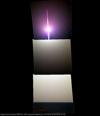
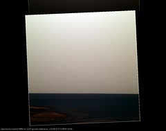
Some Pancam images were taken on sol 1224, no doubt to study the sky during the dust storm. Of course brightness levels of these stretched JPGs are all over the place, but I think it does look dusty. The time was about 3:20 local Mars time.
Bill Harris
Jul 5 2007, 04:08 AM
Interesting animation, Fredk. It is also instructive to make an animation of those two images adjusting the levels of the sunlit areas to be similar in addition to the shadow areas being similar as done previously. The on-the-ground effect is that the shadows appear markedly brighter with increased dust.
Rather the difference between LosAngeles and Palm Springs
--Bill
CosmicRocker
Jul 5 2007, 04:15 AM
The dust seems to have softened the light, making the pancam 1x4 appear prettier than normal on sol 1224. I was waiting for Mike to update the metadata so I could use anti-vignetted images from MMB, but it seems I couldn't fully compensate for the brightness variation between images. I didn't screw with the color balance, because I liked the false color in this set. If someone can correct the brightness banding, this set of pancams will make a gorgeous postcard.
Click to view attachment
You're right Cosmic, lovely subtle light here at the moment...
Click to view attachment
nprev
Jul 5 2007, 05:51 AM
Nice, Stu. The lighting reminds me of the diffuse illumination we get here in LA when the marine layer is moderately thick...gives kind of a homey feel to the image, oddly enough.
Shaka
Jul 5 2007, 06:44 AM
But Mars doesn't make your eyes water.

nprev
Jul 5 2007, 07:16 AM
I don't know...you get some of this micron-scale dust in your helmet somehow, would put that up against LA smog for sheer eye-watering capability....


Tesheiner
Jul 5 2007, 07:37 AM
We have a new navcam picture of the tracks.
The first one was taken on sol 1216 and I remember we talked about the remarkable difference between the first set of tracks (from sol 1214) and the second one (from sol 1216). The second picture was taken yestersol (sol 1224).
Click to view attachment Click to view attachment
MarsIsImportant
Jul 5 2007, 09:30 AM
There is no question about it. Large changes are occuring in a relatively short period of time. This is something new. Changes like this have never been seen this dramatically at any other time during the mission.
Pertinax
Jul 5 2007, 12:24 PM
QUOTE (fredk @ Jul 4 2007, 11:49 AM)
Thanks for that, Tesheiner. I made an animated gif with
this 1217 frame and
this 1223 frame. They are only 9 minutes apart in local time, and you can just make out the shadow of the right wheel in the 1223 view, but the shadow of the deck is almost invisible. This really gives you a good sense of how dusty the sky must be. Note that the arm has moved between these frames.
Click to view attachmentFred,
Thank you for the animation. It is also intriguing to watch the wind effects between the two frames (note the 'ribbing' of the tracks near the left wheel and some of the thin layers of dust on the rocks near image-center for a pair out of many examples).
-- Pertinax
Been trying for an hour to get these two to merge but it's just not happening, but they're nice individual views anyway...
Click to view attachmentClick to view attachmentAnd a 456 of the dirty, dirty sky...
Click to view attachment
djellison
Jul 5 2007, 07:49 PM
Any Storm posts should go in here -
http://www.unmannedspaceflight.com/index.p...ic=4375&hl= - it's a seperate topic all of its own I think.
Doug
Pavel
Jul 5 2007, 10:43 PM
QUOTE (Tesheiner @ Jul 5 2007, 03:37 AM)
We have a new navcam picture of the tracks.
The first one was taken on sol 1216 and I remember we talked about the remarkable difference between the first set of tracks (from sol 1214) and the second one (from sol 1216). The second picture was taken yestersol (sol 1224).
Compare the shadows on the mast. It's barely visible on the second image. And the calibration target doesn't seem to have any shadow at all.
CosmicRocker
Jul 6 2007, 02:53 AM
QUOTE (Stu @ Jul 5 2007, 10:41 AM)
Been trying for an hour to get these two to merge but it's just not happening, but they're nice individual views anyway...
Stu: If you are using Autostitch, try increasing the RANSAC parameter "max iterations" to 3500. It can do wonders for a stitch. You can also adjust alpha and beta, but I don't think it's necessary for this panorama.
Tesheiner
Jul 6 2007, 08:09 AM
... and don't forget to set the "SIFT image size scale" to 100%.

MizarKey
Jul 7 2007, 08:14 AM
QUOTE (Stu @ Jul 5 2007, 08:41 AM)
Been trying for an hour to get these two to merge but it's just not happening, but they're nice individual views anyway...
<pictures removed, check the original post>
And a 456 of the dirty, dirty sky...
Stu, I'm a big fan of your imaging work but please retain something of the original filename, even if it's just the Sol the image was taken. When I save images like these, just having 'left-medium' as the file name just kinda sucks. Love the work though.
Sorry bout that MK, guess I'm just not v organised that way!

I tend to do most of my "imaging work" (more like "messing about" ha!) v v early in the day, before I go out to work at 7am, so giving everything nice neat names has to battle with being awake enough not to drown my keyboard in coffee, but I'll try to do better. Glad you like my efforts tho, thanks. Slowly getting the hang of it I think...
fredk
Jul 11 2007, 12:16 AM
Some details on the approach to the white layer in
this Aviation Week article:QUOTE
The plan is for the rover, heading south, to then drive 100 ft. [30 m] into the crater. This will take several days. It will then be commanded tens of meters parallel along the crater wall. The objective will be to reach about a 1-meter-thick white rock layer that cuts through the wall of the entire crater--but at a point where it's easily sampled, not where it's also visible in the high promontories.
30 metres into the crater seems quite far, since at most the white layer is about 20 metres inside the rim.
CosmicRocker
Jul 11 2007, 05:04 AM
Yeah. I didn't take the time to measure distances with AlgorimancerPG, but apparently they intend to enter at the best place to cross the ripple on the rim, and then traverse the slope in a northeasterly direction toward the northernmost, reachable exposure in the bay. Then they would take a hard right and follow the layer across, to the opposite side. That's one scenario I can imagine would work, and what I suspected they will attempt. The dark/light boundary appears traversable for at least half of it's length.
Then again, we've seen many examples of people tossing around rough estimates in these situations.
Astro0
Jul 12 2007, 03:24 AM
If anyone sees that article in Aviation Week, it's worth noting that the online picture and the main image accompanying the printed version, first appeared here on UMSF.
It's the 'Opportunity Descends into Victoria Crater' image that I did a few weeks back before the storm.
The image is credited: Glen Nagle, Doug Ellison, unmannedspaceflight.com.
Thanks to 'marsloon' for helping to make this happen.
Yippee! Another score for the UMSF team.
Astro0
Shaka
Jul 12 2007, 04:51 AM
How true! The image magicians of UMSF are a science editor's
Best Friend.

Bill Harris
Jul 13 2007, 11:36 PM
For those still following the exploits of Oppy, she's started to move around to the entry point.
--Bill
Geographer
Jul 14 2007, 12:24 AM
Awesome! So the storm's blown over and sunlight's streaming in?
MarsIsImportant
Jul 14 2007, 03:13 AM
No. The storm is not over. But the rover has not been doing much for many days. The batteries could be in good shape, so they decided to use them a little. I think the movement is more for collecting useful data during the storm than actually getting to the entry point.
Chmee
Jul 14 2007, 02:25 PM
QUOTE (Geographer @ Jul 13 2007, 08:24 PM)
Awesome! So the storm's blown over and sunlight's streaming in?
I think an appropriate song at this point would be the Beatles "Here Comes the Sun"
Indian3000
Aug 10 2007, 08:57 PM
nprev
Aug 10 2007, 09:54 PM
QUOTE (Chmee @ Jul 14 2007, 07:25 AM)
I think an appropriate song at this point would be the Beatles "Here Comes the Sun"
"
It's all right..." yeah, sure hope so for our "
little darlin'...
ElkGroveDan
Aug 10 2007, 11:37 PM
That entry animation is cute, however I think it's going to be like Endurance - two feet and then a RAT under foot, another two feet, another RAT all the way for each obvious layer.
glennwsmith
Aug 12 2007, 04:46 AM
ElkGroveDan: Agreed -- what would be the point otherwise? Unless they are going directly for the deepest, most quickly reached layer, with the idea that the rest can be filled in on the way out . . .
Space
Oct 7 2007, 10:48 AM
dilo
Oct 7 2007, 01:41 PM
Nice stitch, Space... which software are you using.
I made this one with Autotstich but I encountered some difficulties in order to reproduce a correct crater slope everywhere:
Click to view attachmentAnd this is an elaboration (with sharpening) of left portion:
Click to view attachment(both pictures are 70% original scale)
tdemko
Oct 9 2007, 11:10 AM
The pans provided by space and dilo show some nice views of eolian erosional features called yardangs:
http://www.tec.army.mil/research/products/...heet/lsyard.htmThe features at Victoria are mico-yardangs, only a few centimeters/ten's of centimeters high.
I wonder if these features set up the pattern that results in the embayed nature of Victoria's rim -- the emabyments and projections are just larger yardangs that have undergone some mass-wasting and undercutting due to differential erosion to make the near vertical cliffs. It would be a satisfyingly fractal landscape evolution story!
This is a "lo-fi" version of our main content. To view the full version with more information, formatting and images, please
click here.