floron
Jul 10 2009, 12:09 AM
QUOTE (jmknapp @ Jul 8 2009, 07:16 AM)

Maybe Apollo 17 would be of more photographic interest? Since the rover traveled around quite a bit (35km total traverse), is it possible that its tracks would show up on the photo as discernible lines? It's at longitude 31E which should come up a bit quicker, this Saturday.
From the LRO blog: "Saturday NAC imaging is again planned with our first off-nadir slews to perform the requested targeting. " hmm. i wonder what target was being requested...?
http://lroupdate.blogspot.com/
Ian R
Jul 10 2009, 12:42 AM
Just in case an attempt at imaging the the Apollo 17 landing site really is imminent, I thought I would post this mosaic I made a while ago from frames taken from the 16-mm ascent film shot just after pitch-over. As far as I'm aware, this is currently the best overhead view of the region where Challenger landed, and it would be interesting to compare this to the putative LRO view of the same area:
Click to view attachment
jmknapp
Jul 10 2009, 01:42 AM
QUOTE (floron @ Jul 9 2009, 08:09 PM)
From the LRO blog: "Saturday NAC imaging is again planned with our first off-nadir slews to perform the requested targeting. " hmm. i wonder what target was being requested...?
http://lroupdate.blogspot.com/Maybe so! Off-nadir might make for an more artsy angle, plus it's a pretty hilly area compared to the A11 site. I was just looking on line for a broader view of the "Taurus Littrow" area & couldn't really find one, but here's a snapshot of an image from a book:
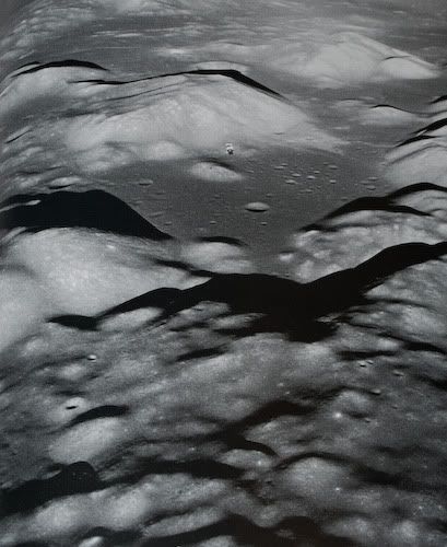
Apollo 17 "Challenger" landed in the flatter region among the smallish craters to the right. The command module "America" is in this photo, silhouetted against the base of the South Massif.
floron
Jul 10 2009, 04:00 AM
perhaps they'll get some nice pics of the HOLLYWOOD signs...

(
from this thread)
charborob
Jul 10 2009, 04:50 PM
Roughly guessing based on the
"Where is LRO?" page, I'd say that LRO will be passing above the Apollo 11 site on Saturday. Since LRO is in a 30x199 km orbit, it's altitude above Tranquillity base will be around 100 km. So we may expect something like 1m resolution?
Zvezdichko
Jul 10 2009, 06:39 PM
I also think that an attempt is possible to be made if not tomorrow, in the next few days. Next week NASA is celebrating the anniversary. It'll be a huge PR for the agency.
charborob
Jul 10 2009, 06:51 PM
QUOTE (Zvezdichko @ Jul 10 2009, 01:39 PM)
I also think that an attempt is possible to be made if not tomorrow, in the next few days. Next week NASA is celebrating the anniversary. It'll be a huge PR for the agency.
Except that if they don't succeed in imaging the Apollo 11 site on Saturday, the next opportunity will be in about 4 weeks, when the ground track crosses the area again.
Zvezdichko
Jul 10 2009, 06:54 PM
Yes, but we had six Apollo landings, we still have opportunities.
jmknapp
Jul 10 2009, 06:54 PM
QUOTE (charborob @ Jul 10 2009, 02:51 PM)
Except that if they don't succeed in imaging the Apollo 11 site on Saturday, the next opportunity will be in about 4 weeks, when the ground track crosses the area again.
Wouldn't it be two weeks, when the other side of the orbit (ascending side?) swings around?
Zvezdichko
Jul 10 2009, 07:05 PM
QUOTE (jmknapp @ Jul 10 2009, 06:54 PM)
Wouldn't it be two weeks, when the other side of the orbit (ascending side?) swings around?
And when the place will be in total darkness.
climber
Jul 10 2009, 07:55 PM
QUOTE (Zvezdichko @ Jul 10 2009, 08:54 PM)
Yes, but we had six Apollo landings, we still have opportunities.
Except we are 10 days away from july 20th
jmknapp
Jul 10 2009, 08:26 PM
QUOTE (Zvezdichko @ Jul 10 2009, 03:05 PM)
And when the place will be in total darkness.
Ah--of course.

I made an animation of the LRO passes over the Apollo 11 site, using the "mission baseline v8" data given at
http://lroc.sese.asu.edu/downloads.html. That baseline was for the original launch date of July 17, & so is about 1 day ahead of schedule. I just figured out how to add fixed points like the Apollo sites to the map projection & this is a first cut:
http://cboh.org/~jmk/lro_apollo11.mpg (54MB mpg file).
I put in all 50 primary LRO targets into the model, but only the handful visible on these ~2 orbits come up.
Joe
Paul Fjeld
Jul 11 2009, 02:59 AM
VERY cool, Joe!
So (just thinking out loud while I run around my cylinder, punching the air :-) the day late means that LRO will be roughly 13 degrees east of the target compared to your LRO_Cockpit view? Looking at the V8 data, the LRO orbit traverses ~12 degrees of Longitude per day? So tomorrow, the cameras should be passing over the Apollo 11 site with a nice 40 degree western sun (or so) and be baked out and focussed. Maybe a shot from 120km will reveal something neat that can be released with appropriate hoopla in the next week or so?
EDIT: I see now that LRO is about to pass over the Apollo 17 site with an even more dramatic sun angle. From 120 km high, the Descent Stage structure (not including the gear) will be nearly 4 pixels wide; the low sun shadow should be considerably more than that. Hope those cameras are baked out and ready!
2nd EDIT: I just read the previous couple of pages and see y'all had figured this out already. Feel a little silly...
jmknapp
Jul 11 2009, 04:22 PM
QUOTE (Paul Fjeld @ Jul 10 2009, 10:59 PM)
So (just thinking out loud while I run around my cylinder, punching the air :-) the day late means that LRO will be roughly 13 degrees east of the target compared to your LRO_Cockpit view?
Glad you got the musical reference! Going by the v8 data, I get 12.94 degrees/day in the commissioning orbit (and 13.13 degrees/day in the mapping orbit). So that amounts to 360 degrees in about 27.4 days. I suppose that makes it sun-synchronous? BTW, assuming that LRO passes over the Apollo 11 site around 4am tomorrow UT (by my calc) the sun will be at around 10 degrees elevation.
Zvezdichko
Jul 11 2009, 04:31 PM
Can't wait to see the new photos!
Paul Fjeld
Jul 11 2009, 05:32 PM
QUOTE (jmknapp @ Jul 11 2009, 11:22 AM)
I suppose that makes it sun-synchronous?
I don't think so. The beta angle is supposed to shift so that by the time LRO is going over the (South?) pole at the time of maximal lighting (summer solstice), it is as near to zero as possible (within some 10 degrees or so) - which was the driver for the launch window. The idea being that they needed passes over the permanently shadowed areas of a pole when those shadows were minimal(?). I am certain the beta angle changes completely through the whole mission or they wouldn't need to do a 180 yaw at the midway point to get the solar arrays shifted to the other side. Plus you wouldn't need that beta gimbal joint on the arrays.
QUOTE
BTW, assuming that LRO passes over the Apollo 11 site around 4am tomorrow UT (by my calc) the sun will be at around 10 degrees elevation.
That will make for some really great images! Much better than 40. The LM shadow will be >so< obvious - I'm sure we'll see the Reflector and Seismometer - maybe even the flag will be a pixel if it did in fact fall over... whet our appetites for the low orbit passes!
Zvezdichko
Jul 11 2009, 05:43 PM
You forget something. The flag was made of nylon. I'm sure there's only the pole left. The rest is ashes.
Plus, the resolution won't be that good.
Paul Fjeld
Jul 11 2009, 06:53 PM
You could be right about the flag - I still harbor a hope that the nylon will not have disintegrated. But the resolution from that altitude is about 1.2 meters per pixel, so if there is a bleached flag flat on the surface, we should see it.
I just googled the specs on Nylon, for what it's worth, and one site (Beaver Manufacturing Co.!) says it is resistant to dry heat but degrades at prolonged exposure of 180 degrees C. The max temperature on the lunar surface is less than 150 degrees C, no?
But I have no idea if it is that simple a calc for the Nylon on the moon over 40 years of solar cycles...
John Moore
Jul 11 2009, 08:09 PM
QUOTE
I was just looking on line for a broader view of the "Taurus Littrow" area & couldn't really find one
ASU is always a wonderful resource for such images -- the zoom feature, literaly, puts you on the surface

Checked out Littrow region -- see
here John
Moon Site
Sunspot
Jul 12 2009, 12:01 PM
The LRO website seems to be really temperamental....
Zvezdichko
Jul 12 2009, 12:07 PM
QUOTE (Sunspot @ Jul 12 2009, 12:01 PM)
The LRO website seems to be really temperamental....
Yes, really... goes down regularly.
jmknapp
Jul 12 2009, 01:57 PM
My s.o. took a picture of the moon this morning with her camera:
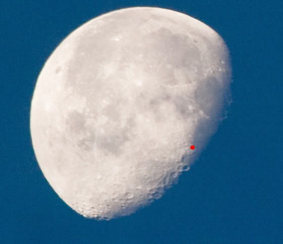
I put a red dot at the Apollo 11 landing site--looks like a nice low sun angle if they took the shot.
ilbasso
Jul 13 2009, 12:12 AM
I think I could have seen the flag if it wasn't for that pesky red dot!
Also, remember that Buzz Aldrin says that the last thing he saw of the landing site during ascent was the flag blowing over in the ascent engine's exhaust plume.
Zvezdichko
Jul 13 2009, 12:26 AM
OK, several amateur pics from me, too:
http://www.space-bg.org/snimki/luna/moon1.JPGhttp://www.space-bg.org/snimki/luna/moon2.JPGhttp://www.space-bg.org/snimki/luna/moon3.JPG12-jul-09/10:50 AM GMT...
Call me ignorant, but I really can't identify the landing site of Apollo 11. Not that it's the best quality.
SpaceListener
Jul 13 2009, 01:55 PM
QUOTE (jmknapp @ Jul 12 2009, 07:57 AM)
My s.o. took a picture of the moon this morning with her camera:
Good! You answered me what I was searching about the Moon phase when Apollo 11 landed on Moon.
I knew that the Moon was either as waxing crescent or waning crescent. Now I see it.
That time is very nice for visual effects with contrasts of light.
A little question of OT, What about was the temperature on the Moon surface during the astronauts external
walk activities?
jmknapp
Jul 13 2009, 02:00 PM
QUOTE (Paul Fjeld @ Jul 11 2009, 12:32 PM)
I am certain the beta angle changes completely through the whole mission or they wouldn't need to do a 180 yaw at the midway point to get the solar arrays shifted to the other side. Plus you wouldn't need that beta gimbal joint on the arrays.
Just verified that per the "mission baseline" SPICE data. The beta angle on the descending node (currently very low) increases to ~90 degrees in about 3 months, goes back to zero at 6 months, then the ascending node will be in sunlight, increasing to ~90 degrees at 9 months & back to zero at the end of one year. So I guess that means that LRO completes a sweep around the moon in one sidereal period (27.3 days) rather than the full moon to full moon period of 29.5 days.
Phil Stooke
Jul 13 2009, 02:16 PM
"Good! You answered me what I was searching about the Moon phase when Apollo 11 landed on Moon.
I knew that the Moon was either as waxing crescent or waning crescent. Now I see it. "
Spacelistener - that image does not show the phase at the time of the Apollo 11 landing - in fact it was almost the opposite, a waxing crescent. In other words, very early morning at the landing site.
Phil Stooke
SpaceListener
Jul 13 2009, 02:31 PM
QUOTE (Phil Stooke @ Jul 13 2009, 08:16 AM)
Spacelistener - that image does not show the phase at the time of the Apollo 11 landing - in fact it was almost the opposite, a waxing crescent. In other words, very early morning at the landing site.
Thanks Phil,
Why did NASA select that the landing Apollo 11 time was in early morning? Due to temperature reasons? I don't see difference temperature between early, noon and late day of Moon since it has no atmosphere but I am still figuring it out.
djellison
Jul 13 2009, 02:34 PM
You want to have the sun fairly low, so that when landing, the craters and boulders stand out well.
I would suspect that you target for the beginning of the lunar day, giving you a few days until the sun gets too high.
SpaceListener
Jul 13 2009, 02:59 PM
Full inline quote removed - ADMIN
Your post sounds very reasonably.
That is for a better visibility during the landing and EWA which is very important for security reasons since the Moon light is so intense, that, I imagine, a person would have lots difficulties to discern the surface line.
Phil Stooke
Jul 13 2009, 03:29 PM
You need the low sun to discern surface features, as Doug said. The most important reason for targeting early morning rather than late evening was to allow the approach to the site to occur over the illuminated region for navigation updates - they tracked landmarks to update their position. Also this will allow for landing delays. If you have some little problem that prevents landing on one orbit you can go for the next, or the next again. In the evening, miss an orbit or two and you will be on the surface during the night. That would be even more important for the longer missions.
Lighting is much more important here than temperature.
Phil
djellison
Jul 13 2009, 03:37 PM
I'm sure I've read one astronaut, probably from a J class mission, comment that just from one EVA to the next, the lighting change was so significant that the place looked very very different on the ground.
Phil Stooke
Jul 13 2009, 04:03 PM
Right, it's very apparent in the surface photos. So it makes perfect sense to land with the lowest sun angles and see all the hazards (except for the blowing dust... but that's a different issue), and allow the sun to get higher during the EVAs. It makes no sense to land with washed-out topography and run the risk that a landing delay would mean the last EVA would have to be cancelled due to approaching night.
Phil
SpaceListener
Jul 13 2009, 04:04 PM
Fantastic, Doug and Phil statements have closed very well about all reasons for early morning landing on Moon.
However, for just confirmation of my hipothesis is that the Moon surface temperature on that time on Sun side is so hot as over than 100 centigrades Celius, isn't it?
djellison
Jul 13 2009, 04:48 PM
http://www.solarviews.com/eng/moon.htmMean surface temperature (day) 107°C
Mean surface temperature (night) -153°C
Maximum surface temperature 123°C
Minimum surface temperature -233°C
SpaceListener
Jul 13 2009, 05:57 PM
Thanks Dougs for the links. I knew about these temperatures and I am sorry that I didn't explain thoroughly about the hypothesis. As the Apollo 11 landing time was on early morning, close to the Lunar Terminator, and am suppossing that the real temperature must be lower than the maximum.
By the way, I have seen a picture taken by the LCROSS, from infrared camera during its approach to the Moon. It showed that the temperature starts to lower at the Terminator. See the next link:
LCROSS Infrared Camera.
Well, I hope that one of the LRO instruments, DIVINER would be able to map the Moon surface temperatures. Patience!
Phil Stooke
Jul 15 2009, 06:36 PM
Sunspot
Jul 15 2009, 06:58 PM
glennwsmith
Jul 16 2009, 04:12 AM
Speaking of radar, and in anticipation of the LCROSS impact, can someone briefly explain (or point me to an explanation of) how the Arecibo observatory has been able to map the poles of both the Moon and Mercury, finding water at the latter but not the former? Seems like it would have the same (impossible) tangential view that we do from earth. Or is its radar sufficiently robust to be able to penetrate the poles "from the sides" and obtain useful reflections that are processed tomographically?
nprev
Jul 16 2009, 04:31 AM
In the case of Mercury I'd guess that Arecibo's acuity there is at least partially a function of the planet's orbital inclination with respect to the ecliptic (7 deg.), which allows a slightly better look angle at the poles at certain times.
Arecibo's radar isn't nearly powerful enough to do a CAT-scan of the lunar poles, though. (I don't think that any ground-based radar yet built could do that.)
dvandorn
Jul 16 2009, 04:48 AM
Also, isn't it true that there is still a fair degree of controversy over the "discovery" of water ice at the Mercurian poles by Arecibo radar mapping?
I'm tempted to say that all we *really* know is that Mercury's poles show something different than the Moon's poles to Arecibo's radar mapping program. I don't think we can say with any degree of certainty what compositional and environmental differences are causing it.
-the other Doug
jmknapp
Jul 16 2009, 12:04 PM
QUOTE (SpaceListener @ Jul 13 2009, 09:55 AM)
Good! You answered me what I was searching about the Moon phase when Apollo 11 landed on Moon.
I knew that the Moon was either as waxing crescent or waning crescent.
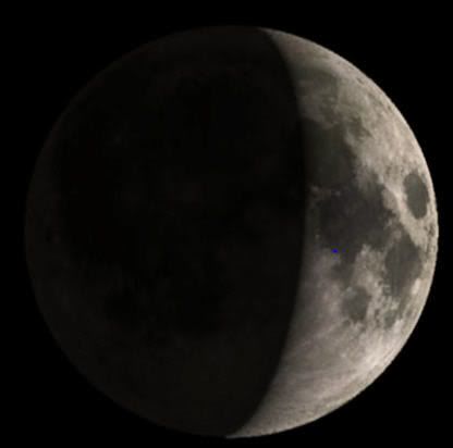
Here's about what it looked like at the moment of landing, 20JUL1969 20:17:40 UT (blue dot at the A11 landing site):
Zvezdichko
Jul 16 2009, 06:35 PM
Btw happy anniversary, today restored video footage from Apollo 11 was released. I do wonder if we will see any LRO pictures of the landing sites in the near hours/days.
ugordan
Jul 16 2009, 06:43 PM
QUOTE (Zvezdichko @ Jul 16 2009, 08:35 PM)
I do wonder if we will see any LRO pictures of the landing sites in the near hours/days.
Via NSF.com:
MEDIA ADVISORY: M09-133
NASA BRIEFS MEDIA ON NEW IMAGES OF APOLLO LUNAR LANDING SITES
GREENBELT, Md. -- NASA's Lunar Reconnaissance Orbiter, or LRO, has
sent back its first images of Apollo lunar landing sites. The agency
will release the images Friday, July 17, at noon and hold a
teleconference at 2 p.m. EDT to discuss the photos and future plans
for the LRO mission.
Participating in the teleconference are:
Michael Wargo, chief lunar scientist, NASA Headquarters, Washington
Richard Vondrak, project scientist, Lunar Reconnaissance Orbiter,
NASA's Goddard Space Flight Center, Greenbelt, Md.
Mark Robinson, principal investigator, Lunar Reconnaissance Orbiter
Camera, Arizona State University
To participate in the teleconference, reporters should contact Grey
Hautaluoma at 202-358-0668 or Andy Freeberg at 301-286-0746, by noon
Friday.
To listen to the event online, visit:
http://www.nasa.gov/newsaudioFor more information about LRO, visit:
http://www.nasa.gov/lro
Phil Stooke
Jul 16 2009, 07:06 PM
Yummy!
Phil
Paul Fjeld
Jul 16 2009, 08:06 PM
I think they could have bagged every single landing site with that great low, western sun angle this past week. Plus who knows what else (LM, SIVB craters).
jmknapp
Jul 16 2009, 08:21 PM
QUOTE (Paul Fjeld @ Jul 16 2009, 04:06 PM)
I think they could have bagged every single landing site with that great low, western sun angle this past week. Plus who knows what else (LM, SIVB craters).
In the July 15th space.com article referenced upthread, I guess they were sandbagging a little as the photos must already have been taken several days before. Anyway, that article says:
QUOTE
For the Apollo 11 site, "you will definitely see this square thing sitting on surface," said LROC's Principal Investigator, Mark Robinson of Arizona State University in Tempe. At low sun it's likely that the lander legs will cast shadows. "It will be unambiguous that the descent stage is sitting there," Robinson said.
The descent stages of other Apollo missions should be visible, too. And the orbiter will look for Apollo Lunar Surface Experiment Packages (ALSEP) an array of scientific devices deployed on the lunar surface by Apollo moonwalkers.
"I know we'll see the descent stages...and I know we'll be able to find the ALSEPs," Robinson told SPACE.com. "You'll see things sitting on surface." Churned-up lunar regolith, the tracks of the three lunar rovers used during the Apollo program, should also be visible.
http://www.space.com/missionlaunches/09071...nding-site.html
John Moore
Jul 16 2009, 08:53 PM
QUOTE (glennwsmith @ Jul 16 2009, 05:12 AM)
Speaking of radar...how the Arecibo observatory has been able to map the poles of both the Moon and Mercury
Good description
here by Campbell who was involved with those radar moon images.
John
MoonSite
Stu
Jul 16 2009, 09:23 PM
This map might be helpful tomorrow, after the landing site images are released and we're all trying to identify features / tracks at Tranquility Base :-)
http://history.nasa.gov/alsj/a11/a11traverse.gif
Phil Stooke
Jul 16 2009, 09:46 PM
This is a "lo-fi" version of our main content. To view the full version with more information, formatting and images, please
click here.