atomoid
Apr 2 2007, 10:01 PM
QUOTE (MarsIsImportant @ Apr 2 2007, 08:44 AM)

I agree. That's why I don't think the primary source of these streaks is wind related. Wind has only slightly modified them.
Those streaks being composed of remnant bedrock (shielded from erosion by the blueberries themselves) as opposed to actual dust collections in the lee tails. so this would suggest were lookng at two different processes here (or maybe three different, if the dark dust inside the crater is different than the dark streaks)
I had assumed that the dark streaks were simply dust accumulations from the eroding cliffs, spilling out onto the plains in tails since its denser than the light dust and would of course be deposited in such a pattern, since that explanation looks obvious to my untrained eye from orbit.
However, it seem that now that we are pretty sure the streaks are composed of blueberries themselves (or are we?).
So this (should) only mean that the blueberries are cleaned by the turbulence exiting the crater, and perhaps the blueberries rinds have even been chemically altered by moisture and/or other minerals spilling up from the crater as well, or perhaps the dark dust has merely 'stuck' to them through this type of process...
We shall soon see
Edward Schmitz
Apr 3 2007, 01:06 AM
At the top of duck bay, there is a dune on the lip of the crater. This suggests to me that the area outside of the bays is a depositional environment. It only makes intuitive sense. The wind would speed up in the bay due to the relative restriction of the bay walls. Once the wind tops the bay, it has the entire planes to spread out again - and slow down.
Another thing... The prevailing winds move from southeast to northwest. But its the northeastern bays that have the streaks. It is also the northeastern bays that have the dark dunes at their base. If the streaks were a cleaning process, shouldn't Bottomless and Bahia Blanca be more efficient cleaners?
just my thoughts...
Tesheiner
Apr 3 2007, 04:09 PM
Opportunity left the VWP area today (sol 1134).
Navcams:
http://qt.exploratorium.edu/mars/opportuni...cam/2007-04-03/What's not clear to me is if the plan was to investigate the dark streaks *now* or after moving onto Cape St. Vincent.
fredk
Apr 3 2007, 04:32 PM
I interpreted what we heard as "now". Actually no mention was made of visiting CSV, though it would be out of character to skip a cape. Then again, they are about to head back to Duck Bay.
From the planetary society update:
QUOTE
"The next step after characterizing the slopes is to drive right into one of those dark streaks that emanate from a couple of these alcoves. ... We will drive into the darkest spot of the darkest dark streak and try to find out what's going on there."
After that, Squyres said the plan for Opportunity is to follow the dark streak back to its source at the rim of the crater, do some work there, then drive out onto the next promontory, named Tierra del Fuego, and take picture of the eastern face of Cape St. Vincent.
imipak
Apr 3 2007, 07:41 PM
QUOTE (fredk @ Apr 2 2007, 04:28 PM)
I wrote above that we have dark deposits in the lee of blueberries here. At the bottom of
this pancam view we can see sizable collections of dark dust in the lee of some small rocks. Again, doesn't this suggest the darkness is a deposit rather than a removal of light material?
Possibly... if similar rocks at other, non-streaky points around the rim don't show the same leeward deposits. I don't recall seeing any, but then I wasn't really looking for them. Also - what about scale? Those small deposits are small and scattered; they would have to be present all over the surface of the dark streaks, ie out on the plain. I imagine the next few sols should clear that up.
The case for it being a wind-related phenomena of one sort of another is pretty hard to dispute now, IMO. There's no other evidence for recent water close enough to the surface to affect anything, that I know of; [Edit: apart from the MGS gullies, altered faults and so on, that is

but there's no gullies here, and the fault-line halos are surely long slow processes. These wind streaks have to be caused by something that happens often enough for them to persist through global dust storms, etc., ie. very very recent.)
Also, if that were causing the dark streaks, there'd be similar features out on the plains - and there aren't.
Either wind is carrying fines out of VC and dropping them where the wind speed drops (ie., in the lee of the rim), or wind coming out of VC is blowing dust off the surface. C'mon JPL/Cornell, open the gold envelope already!
Edward Schmitz
Apr 3 2007, 10:02 PM
The streak disappears in the L7 filter. I believe that rules out surface texture as the cause.
monty python
Apr 4 2007, 05:40 AM
Just to clarify things for me, we are proposing winds comming generally from the south and scouring or depositing material. So these winds are running parallel to the dunes we (oppy) drove thru. So those dunes must be at the moment fossil dunes, as I wouldn't expect dunes to line up parallel to the wind.
If the wind occasionally shifts to move the dunes, would we see evidence of old streaks? Just what relative ages do we put on these features?
Brian
mhoward
Apr 5 2007, 04:59 AM
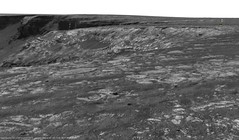
Opportunity Sol 1131 Pancam L2 mosaic, equirectangular projection:
dilo
Apr 5 2007, 06:10 AM
Thanks to Michael for equirectangular mosaic...

Floyd
Apr 5 2007, 06:12 PM
No images at Exploratorium from either rover for past 27hr. Anyone know if data is showing up elsewhere or if something is up?
djellison
Apr 5 2007, 08:02 PM
27 hours and your in a panic already.

Sol 18A would have put you in an early grave!
Spirit - it's 1157.4 now - they have 1156 data on the ground, 1157 is scheduled as a heavy MI workout
Oppy - currently 1137.0 - they have plenty of 1136 data on the ground with 1137 not yet scheduled.
Doug
MarsIsImportant
Apr 5 2007, 10:13 PM
I'm intrigued by this image from Oppy of the Valley Without Peril.
http://qt.exploratorium.edu/mars/opportuni...90P2395L2M1.JPGI'm not sure but--Comparing the MRO overhead images with this one suggests some changes in the mini-dunes of the bay since the MRO one was taken. The critical part is toward the bottom of the new Oppy image; yet it is cut off, so I may be looking at the features wrong. Is what I'm seeing real or am I seeing things?
Also, it looks like an ingress here maybe possible afterall. It is just a question of whether they want to enter through a minidune on a slope that might prevent them from getting out again. The dune is so small that I think they might test it with a toe dip. But then again, what is the real advantage of going into Victoria here?
atomoid
Apr 5 2007, 11:15 PM
QUOTE (MarsIsImportant @ Apr 5 2007, 02:13 PM)
I'm intrigued by this image from Oppy of the Valley Without Peril.
http://qt.exploratorium.edu/mars/opportuni...90P2395L2M1.JPGI'm not sure but--Comparing the MRO overhead images with this one suggests some changes in the mini-dunes of the bay since the MRO one was taken. The critical part is toward the bottom of the new Oppy image; yet it is cut off, so I may be looking at the features wrong. Is what I'm seeing real or am I seeing things?
that image was from SOL 1131
You can pull back an get a broader look from the earlier
SOL 1130 so what youre looking for should be in
this image, although i dont see much anything out of the ordinary (except for extraordinary and mysterious images of Mars that is), what was it you were trying to point out?
the overhead shot detail:
Click to view attachment----
On a side note, here is a really good example of where the blueberries appear to have been 'pushed-up' like little terminal moraines around the bedrock plate boundaries has always fascinated me, yet i haven't really heard any explanation of their origin. i would suggest that they have fallen out ofhte bedrock this way as it is eroded, more blueberries fall out and roll down the remaining rock to pile up along its edge and then the edge and its bedrock are gone (to ground level) you end up with little piles like crime scene outlines for each depleted bedrock chunk.
Click to view attachmentno actually, that would mean that the cracks should be filled in as well, right? ok im lost again.
jvandriel
Apr 8 2007, 01:31 PM
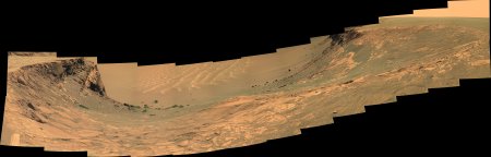
A panoramic view over Victoria Crater.
Taken with the L2 Pancam on Sol 1137.
jvandriel
Ant103
Apr 10 2007, 07:24 AM
The Bay "without" peril

AndyG
Apr 10 2007, 08:21 AM
Absolutely beautiful, Ant. That's easily one of my Oppy favorites.
Andy
fredk
Apr 11 2007, 03:41 PM
A couple of long baseline stereo views looking down VwP to the dunes, from sols 1131 and 1133:
Click to view attachmentClick to view attachment
jvandriel
Apr 15 2007, 02:07 PM
The Panoramic view and a look in the drive direction
on Sol 1142.
Taken with the L2 pancam.
jvandriel
Martial
Apr 15 2007, 09:56 PM
QUOTE (jvandriel @ Apr 15 2007, 04:07 PM)
The Panoramic view and a look in the drive direction
on Sol 1142.
Taken with the L2 pancam.
jvandriel
Why you pictures are allways so little ? It's a pity. I allways hope that the next one, it will bee bigger.. but no.
BrianL
Apr 16 2007, 03:43 AM
QUOTE (Martial @ Apr 15 2007, 03:56 PM)
Why you pictures are allways so little ?
Umm... have you tried clicking on them?
Brian
CosmicRocker
Apr 16 2007, 04:19 AM
I think he's asking why jvandriel's images are reduced in size from the original.
jvandriel
Apr 16 2007, 05:07 PM
The images are reduced in size because it's one
of the rules not to publish images bigger as 1 MB.
It has to do with backup's of the site and other
housekeeping. It take's very much time to completely
backup the site with a lot of big pano's, 6MB or even bigger.
I have no other address to download the pano's and mosaics.
I only publish the pano's here at unmannedspaceflight.com
For myself, I have now more than 2500 pano's and mosaics
for Spirit and Opportunity. Original size.
jvandriel
alan
Apr 20 2007, 03:29 AM
There are several rocks like this one with low rings near their edges. Anyone care to offer an explaination as to how these form?
Click to view attachment
CosmicRocker
Apr 20 2007, 04:27 AM
Be careful what you ask for, alan.

There are a variety of geological processes that can create such features. A discussion of them could quickly turn into something like the Great Dust Debate...on steroids.
They are interesting, though, aren't they? I'm tempted to speculate, but...
fredk
Apr 20 2007, 04:27 AM
Fascinating. Now what we need to do is form two camps and start a new debate!
Also in that image you can see some ripples. These are I think the first in a long time, but I think Oppy can maneuver them without difficulty!
From the new viewpoint we can
just about see our arrival point to Victoria behind Verde in the upper right of this image:
http://qt.exploratorium.edu/mars/opportuni...V4P2405L2M1.JPG
mhoward
Apr 20 2007, 04:51 AM
CosmicRocker
Apr 20 2007, 05:39 AM
Don't even start to tempt me with those
relict ripples.
fredk
Apr 20 2007, 03:38 PM
Well, I guess I'll be the first to stick my nose out and take a stab at the ringed ejecta blocks.

We start with some ejecta blocks in the ejecta blanket whose surfaces have been altered in some way. Those blocks erode down in the wind, like the rest of the blanket, to the current flat apron surface. But the altered surfaces are a bit more resistant to erosion than the interiors of those blocks. The result is that the surface of the apron consists of cross-sections of all the blocks, but those with altered surfaces ("rinds"?) will have a slightly raised rim, corresponding to the rind, and a slightly depressed interior. Dark berries/sand tend to accumulate in the depressed interior, just like we see in the navcams.
Obvious questions are what caused the alteration and when did it occur. Since presumably the surfaces of the blocks were only exposed after impact, I guess the alteration had to happen after that. Could the heat of impact be responsible? Why would some blocks be altered this way but not others?
Edward Schmitz
Apr 20 2007, 07:18 PM
Perhaps the answer to that would also answer the origin of the dark matterial...
That's purely wild speculation...
mhoward
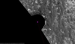
Apr 21 2007, 03:56 PM
A view of Opportunity at her sol 1150 location, more or less
jvandriel
Apr 21 2007, 05:20 PM
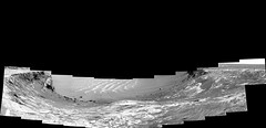
Here is the Navcam panoramic view from Sol 1150
taken with the L0 Navcam.
jvandriel
jvandriel
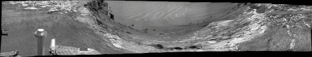
Apr 21 2007, 05:24 PM
and the Pancam L2 view from Sol 1150.
jvandriel
Ant103
Apr 22 2007, 04:33 PM
Hi
The last panorama I've made. This is the one of the biggest Opportunity's pan I've made.
This is the Valley Without Peril :
It was hard to make gain compensation on these pictures because of the large brightness differences between one image and an other... But I succeed to this.
fredk
Apr 23 2007, 04:52 AM
Beautiful, Ant! Thanks.
fredk
Apr 23 2007, 03:18 PM
QUOTE (alan @ Apr 20 2007, 03:29 AM)
There are several rocks like this one with low ... rings near their edges.
Judging from the sol 1152 pancams, those also caught the eyes of the rover planners. This anaglyph shows that these particular rings are raised:
Click to view attachmentIt does look like there's a tougher crust around these blocks.
CosmicRocker
Apr 24 2007, 04:35 AM
Ok, this has become too interesting to ignore. I think we saw the first vestiges of this phenomenon a long time ago. It is rather curious, because some ejecta blocks exhibit it, and some do not. We've only seen down to the ejecta bedrock surface in a few areas, but it does seem to be more prevalent on the north side. More rock is exposed here, though.
My first thought upon seeing something like this is to suspect that a resistant rind formed on the blocks through some kind of secondary alteration of the blocks, such as heat from the blast or post-impact exposure to water. But it could be that something caused the central cores of the blocks to become softer and less resistant to erosion.
But, there is yet another way to look at it. We've seen plenty of blueberries piled up in various configurations around the peripheries of the blocks, and sometimes in the middle of the blocks. Atomoid has
already proposed a plausible mechanism for certain surface concentrations of concretions.
I honestly don't know what the underlying cause is, but I can imagine a concentration of berries and other stuff temporarily protecting the edges of blocks from wind erosion until some time when the elevation difference between the edges and the centers of the blocks becomes great enough to encourage the berries to roll into the low areas and protect them for a while.
Whatever is the cause, it seems to be something that is occurring on the horizontal surface, since we have not seen signs of crusts or rinds on the blocks in the vertical cross sections.
ngunn
Apr 24 2007, 08:59 AM
Perhaps the rocks buried at depth were water-rich at the time of impact and their exteriors were hardened in some way by rapid dessication once exposed.
algorimancer
Apr 24 2007, 03:49 PM
Just to play devil's advocate, here's a potential mechanism which doesn't (necessarily) involve water:
Let's assume that the rocks undergo a greater temperature range in each sol than does the surrounding soil (I might expect that the soil would be somewhat insulating, whereas heat might conduct more readily through solid rock). Thus the bulk of the rock would experience a particular range of relatively uniform physical expansion/contraction over the course of a day. However, the edges of a rock - being adjacent to the insulating soil - would be more stable in temperature and thus not undergoing the extremes of expansion/contraction of the bulk of the rock. Clearly it would not be unexpected that cracks might occur along the interface between the bulk rock and the edge rock due to the differential expansion. The vicinity of these cracks would be more susceptible to wind erosion, and the net result (hundreds of millions to billions of years later) would be the surfaces we see today. One obvious question is that of why we haven't been seeing this phenomenon throughout Oppy's traverse - it seems that the composition of these rocks must be somewhat unique.
This notion would be easily tested by imaging a rock closely enough to establish whether cracks define the base of the depression along the edge, though if the depression is filled with sediment it may be necessary to use the ratt.
imipak
Apr 24 2007, 07:35 PM
A wild (wild as in "silly") idea:
Observation: a strip equidistant from the edge of each rock showing this effect has no dust or blueberries on it.
Posit: something other than gravity alone is moving dust, sand, blueberries etc off those border areas.
Hypothesis: ground vibration or movements.
It would be interesting to see a map showing the distribution of such rocks... they appear to be clustered in one location; with what other factor does that area correspond?
Floyd
Apr 24 2007, 11:42 PM
QUOTE (algorimancer @ Apr 24 2007, 11:49 AM)
One obvious question is that of why we haven't been seeing this phenomenon throughout Oppy's traverse - it seems that the composition of these rocks must be somewhat unique.
I think an explanation is the surface here (at the edge of Victoria) is being very actively shaved down by the wind.
Floyd
CosmicRocker
Apr 25 2007, 05:04 AM
It seems difficult to use water saturation to explain these, because we only see the things on the surface. I couldn't find evidence of these rims in the vertical cross sections of blocks in the capes. You might be able to come up with a scenario where frost, capillary films, precipitation, or some such is involved at the surface.
I devoted several hours to looking through panoramas from the larger mission tonight. The earliest location where I found similar, unambiguous features was at Cabo Anonimo, at around sol 1030. There were very few maybes from earlier dates. Cabo Anonimo was the first area around the rim of this crater where the surface bedrock was clearly visible to Opportunity, so these things might have been present, but buried at other locations. The only other surface I found that was broadly similar was that around Endurance, but the ejecta blocks were mostly covered completely by concretions and soil. There were some blocks that had their edges covered by obvious concentrations of outlining berries, but the underlying rock was not visible.
I also noticed plenty of blocks everywhere that were partially outlined by berry piles, and which did not display these curious features. We need more ideas, or observations.
jvandriel
Apr 25 2007, 07:00 PM
The L0 Navcam view from Sol 1153.
jvandriel
jvandriel
Apr 25 2007, 07:36 PM
Here is the view from Sol 1155.
Taken with the L0 Navcam.
jvandriel
atomoid
Apr 25 2007, 10:19 PM
more
food snacks for thought...
- if the raised outline piles are not
relics co-evolved with disintegrating evaporite chunks, then...
- examine the
bottom of this ..image for a prime example of a crack boundary berry pile.
It looks so much as if the berry piles have been extruded from or pushed out of the crack area, almost as if the bedrock were a plate that had been lifted and fell back down and left a berry splash at one side. although there doesn't seem to be any reasonable method this could occur. we could play devil's advocate with some radical contraction/expansion model: in addition to Algorimancer's temperature-based model above, how much water can the sulfates adsorb/lose over time? and maybe there are other factors such as underground water freezing related expansion as well..
..if there is enough related contration/expansion considering all factors, it might form some sort of pushing mechanism that builds the little piles up over time, spilling out on one side or another and remaining until the next cycle. From looking around, it seems that most of the cracks in other areas seem to be less-filled than expected, since i'd expect all cracks to be filled up with blueberries long long ago, indeed it seems as if there may be even some recent contraction that has opened them up a bit to swallow soils, and the topography of the crack might help the wind keep the dust out of them to a large degree, if the lack of material were due to lack of blueberry concentrations.
..but also consider that there may be 'pockets' of salts under the surface that were concentrated as these saturated areas underwent drying, it might have formed salt pockets that have a much greater than average amount of expansion/contraction related to this, this could of course be low enough under the surface that it subtley lifts the plates on one side or pushed up material that has fallen into the cracks. which might account for these intriguing first-order Mars-mystery features were seeing. okay i guess im rambing now...
CosmicRocker
Apr 26 2007, 04:35 AM
I find it amazing that the little jaunt back up the cape to image the other half of the LBL stereo brought us so many blocks in different stages of evolution. The sol 1155 images have me even more bewildered than ever. I still really like your "chalkmark" idea as a beginning point, but the impact is very old and there is no telling how long ago the ejecta began to erode. Supposedly, this crater was filled with sediment after the impact, which was later removed.
Who knows what modifying forces the eventual berry piles became subject to? Along much of the journey south we saw examples of berry piles along bedrock cracks. I recall Bill calling similar things "wrinkled rug structures." Back then we mostly wondered about the bedrock fractures and how they might be "sapping" fine grains away. Now, we arrive here, and we see similar things, and some really different things.
We've already seen a lot of blocks with elevated rims. Here, there are several with depressed rims. Take a look at the block left of and somewhat below center in this image. It's center is raised, and berry piles currently occupy portions of the perimeter.
http://marsrovers.jpl.nasa.gov/gallery/all...EP0605R0M1.HTMLThen there is an even more curiously rimmed block where part of the rim is taller than the center and part of it is lower.
http://marsrovers.jpl.nasa.gov/gallery/all...EP1312R0M1.HTMLI only hope there might be a geomorphologist with influence who can get us a bottom row of pancams here. I am beginning to wonder if these concretions might serve a dual purpose. Sometimes they protect the rock from wind erosion and sometimes they might promote it.
fredk
Apr 26 2007, 03:11 PM
QUOTE (CosmicRocker @ Apr 24 2007, 04:35 AM)
... I can imagine a concentration of berries and other stuff temporarily protecting the edges of blocks from wind erosion until some time when the elevation difference between the edges and the centers of the blocks becomes great enough to encourage the berries to roll into the low areas and protect them for a while.
Whatever is the cause, it seems to be something that is occurring on the horizontal surface, since we have not seen signs of crusts or rinds on the blocks in the vertical cross sections.
I really like this berry-protection idea. But I'm not convinced we
should've seen signs of crusts on the slopes. The raised rims that we see on the plain are highlighted by berries and dark grains, but these won't stick on a steep enough slope. Without the dark highlighting the crusts would be hard to see from a distance, and we haven't had very many very close views of blocks embedded in slopes. We should examine the slopes very closely for any signs of rinds.
atomoid
Apr 26 2007, 10:02 PM
QUOTE (CosmicRocker @ Apr 25 2007, 09:35 PM)
...I am beginning to wonder if these concretions might serve a dual purpose. Sometimes they protect the rock from wind erosion and sometimes they might promote it.
Good catch on pointing out these beveled/anti-beveled block edges ...i am stumped, but i like that last sentence, for a brief moment i saw berries rolling around in the wind clanging together much like the little pebbles eroding out their little bowls in streambeds and coastal bedrock.
CosmicRocker
Apr 27 2007, 04:41 AM
atomoid: To be honest, it leaves me wanting, but it was all I could imagine from the imagery at hand. It is so fun when our little machines send back these intriguing observations from an alien world. I'm still open to new ideas, but I am stumped, too.
fredk: That's right. I may not have explained myself well enough. You would not expect the concretions to be involved in that process unless it was something taking place on a roughly horizontal surface. When I said we haven't seen rinds on the blocks in vertical sections, I was only arguing that this phenomenon was not likely the result of earlier events (secondary processes) that altered the perimeters of those blocks, like having been saturated with water or melted by heat.
jvandriel
Apr 29 2007, 02:33 PM
Here is the Pancam L2 view from Sol 1155.
jvandriel
Shaka
Apr 30 2007, 06:25 PM
This Bud's for you, Arthur C.!
Thus Spake Zarathustra
This is a "lo-fi" version of our main content. To view the full version with more information, formatting and images, please
click here.