
Full Version: Bahia Blanca
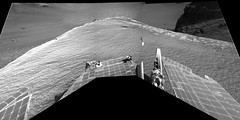
Just had to say that this: 1P222914526EFF78PAP2357L2M1 has got to be one of my favorite raw images so far. I hope we get a decent pan from Cape Desire.
I agree James. I'd thought that this is may be the best close view so far of big rocks that felt inside the crater
There are nice tracks for the white rock a little down from the center of the picture.
Not that the mission team need advice but they might like to know that SHOULD THEY DECIDE to proceed to the tip of Cape Desire and take the MOTHER-OF-ALL-PANORAMAS (with sky please) there would be some VERY HAPPY PEOPLE out here, and (no doubt) an image for the history books. I add my voice to James and climber.
QUOTE (Tesheiner @ Jan 25 2007, 11:53 AM) 
Watch your step, Oppy!!!
Nice blur effect on the low-gain antenna.
Makes it look like Oppy is fishtailing as it fights a slide to the precipice.

QUOTE (jamescanvin @ Jan 25 2007, 11:28 AM)
Just had to say that this: 1P222914526EFF78PAP2357L2M1 has got to be one of my favorite raw images so far. I hope we get a decent pan from Cape Desire.
See the light-toned, mushroom-shaped rock on the near slope? Could that be the effect of sand blasting around the lower part of the rock?
Yikes, is anyone else getting serious flashbacks to Eagle crater? 
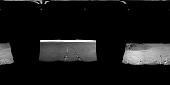
Sol 1068 navcam, as we drop down onto Cape Desire, and look back up at Guam/the "dock".
Sol 53 navcam, inside Eagle crater.
Sol 1068 navcam, as we drop down onto Cape Desire, and look back up at Guam/the "dock".
Sol 53 navcam, inside Eagle crater.
That's a cool comparison, fredk. What I think is most funny about the comparison is remembering back at Eagle how people were initially calling that outcrop "The Great Wall" -- when here at Victoria, the Dock is barely a lump, and all Opportunity has to do is to turn around to see truly great vertical slopes... 
--Emily
--Emily
OMG, Oppy is trying to SUICIDE!!!
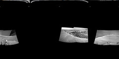
Click to view attachment
(3x1 Navcam L0, sol 1069)
Remember Thelma & Louise...
Click to view attachment
(3x1 Navcam L0, sol 1069)
Remember Thelma & Louise...
No, please, no!!! We'll keep the cops back, we know you're under incredible stress.... 
Interesting vantage point, though. I wonder if she'll tend to track more closely along the rim in order to fully exploit the new steering algorithms (recall the "shuffles" needed to generate guidance datum).
Interesting vantage point, though. I wonder if she'll tend to track more closely along the rim in order to fully exploit the new steering algorithms (recall the "shuffles" needed to generate guidance datum).
A perspective projection:
Oppy still drunk. 
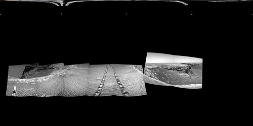
A view of the wheeltracks on Sol 1068.
Taken with the L0 Navcam.
jvandriel
A view of the wheeltracks on Sol 1068.
Taken with the L0 Navcam.
jvandriel
Here are the equirectangulars from Sol 1068 and 1069 - there may be more Navcams to come down yet
The plan for yestersol (1069) included a couple of MIs - no images downlinked yet; only thumbnails on the PCDT web.
It would be the first time the "go & touch" feature is used.
It would be the first time the "go & touch" feature is used.
This is a 2x1 navcam mosaic of Bahia Blanca.
Click to view attachment
There are no images looking into the crater on this batch except for this rhazcam picture. In any case, I feel this place is perfect to take a whole 360º color panorama, perhaps one of those called "Mother of all Panoramas".
The view is breathtaking.
Click to view attachment
There are no images looking into the crater on this batch except for this rhazcam picture. In any case, I feel this place is perfect to take a whole 360º color panorama, perhaps one of those called "Mother of all Panoramas".
The view is breathtaking.
I agree it would be great to have a full pan from this position. The Navcam view so far is great, abeit incomplete:
I doubt the full pan will happen, but maybe at least a full Navcam pan with some Pancam coverage?
I doubt the full pan will happen, but maybe at least a full Navcam pan with some Pancam coverage?
QUOTE (mhoward @ Jan 29 2007, 08:51 AM)
I doubt the full pan will happen,
So do I.
What I would be happy with is if the Bahia Blanca mosaic could be extended to the Soup Dragon. That would be a fabulous image with Hoy, all those big fallen rocks, the next few capes and the Dragon herself.
James
That Bahia shot is really breathtaking. Thanks, Tescheiner!
It also seems at first glance that Bahia may have undergone more pronounced aeolian erosion than other locales...maybe this is the prime 'wind tunnel' for the crater during the diurnal cycle?
Thanks, Tescheiner!It also seems at first glance that Bahia may have undergone more pronounced aeolian erosion than other locales...maybe this is the prime 'wind tunnel' for the crater during the diurnal cycle?
Here is a long baseline anaglyph from the navcams taken at the 1069 and 1071 positions.
Click to view attachment
And here is my version of the 1071 view of Bahia Blanca (full resolution)
Click to view attachment
James
Click to view attachment
And here is my version of the 1071 view of Bahia Blanca (full resolution)
Click to view attachment
James
QUOTE (jamescanvin @ Jan 28 2007, 11:41 PM)
And here is my version of the 1071 view of Bahia Blanca (full resolution)
Wow, that is a really tempting chunk of rock down there.
And for those of you that like mind bending super-long-baseline anaglyph's. Here is one using the images from 1067 and 1071.
Click to view attachment
James
Click to view attachment
James
The full pan doubters may be right, but I still hope not. This is the perfect moment to create that image that space museum goers of the future will stand in the middle of awestruck. To a hard-nosed geologist it might seem like a superfluous 'touristic' gesture, but there is more to this great human adventure than just geology and other prizes to be won besides short term scientific gain.
I'm still waiting for that one navcam pan that makes me go "THAT...is the one"
I think it's a bit further yet - from a perspective that will show us our arrival point really clearly.
Doug
I think it's a bit further yet - from a perspective that will show us our arrival point really clearly.
Doug
Ok, a big 360º panorama is just my wish. I don't see (yet) any planned sequence to support it.
However, there is a nice 6x3 pancam mosaic of Bahia Blanca (aprox. 80º fov) taken at the previous site during sol 1070:
01070 p2359.09 18 0 0 18 1 37 pancam_long_baseline_6x3_part1_L2
So where is the "part2"? II believe the reason to move this couple of meters towards the tip was exactly to take the second shot.
Edited: Tosol (1072) plan doesn't include anything significant.
We'll see what we see.
Mmm, we should move to cape D1 or further to see our arrival point. It's currently behind Cape Verde.
However, there is a nice 6x3 pancam mosaic of Bahia Blanca (aprox. 80º fov) taken at the previous site during sol 1070:
01070 p2359.09 18 0 0 18 1 37 pancam_long_baseline_6x3_part1_L2
So where is the "part2"? II believe the reason to move this couple of meters towards the tip was exactly to take the second shot.
Edited: Tosol (1072) plan doesn't include anything significant.
We'll see what we see.
QUOTE (djellison @ Jan 29 2007, 02:12 PM)
I think it's a bit further yet - from a perspective that will show us our arrival point really clearly.
Mmm, we should move to cape D1 or further to see our arrival point. It's currently behind Cape Verde.
QUOTE (ngunn @ Jan 29 2007, 01:38 PM)
To a hard-nosed geologist it might seem like a superfluous 'touristic' gesture, but there is more to this great human adventure than just geology and other prizes to be won besides short term scientific gain.
I red last week that Mars used to be the "Astonom's" planet and it's now the "Geologist's" planet. I agree with you ngunn, let's have our part of dream back.
QUOTE (djellison @ Jan 29 2007, 01:12 PM)
I think it's a bit further yet - from a perspective that will show us our arrival point really clearly.
By the time we're far enough round to see into Duck Bay we'll be looking up at the opposite rim and all of that long view over the plain to the far hills may be lost. Cape Desire is unusually 'pointy', with clear views looking both up at the beacon ridge and down at - and beyond - the southern rim. That combination gives the eyes all the necessary cues to 'read' the crater's horizontal context as well as its relief. That is why I think this is the best place. If there were an artist on the team they would do it here!
Some info on the new driving techniques in the latest Oppy update:
"Somewhat slippery terrain" they say!
QUOTE
...Opportunity began testing various techniques for visually determining the rover's precise location after moving across sandy, somewhat slippery terrain. Because the sandy surface is largely flat and featureless (except for the dropoff into "Victoria Crater"), the rover's primary reference points are the long rows of repeating ridges and holes in its own tracks. They all look pretty much the same, repeating the same pattern every 80 centimeters (2.6 feet). The rover is working on ways to make its tracks look different at every step, which will remove any ambiguities in the images of the tracks.
If you compare this hazcam view of the latest drive tracks with this older view, it looks like they are using some such technique."Somewhat slippery terrain" they say!
QUOTE (Tesheiner @ Jan 29 2007, 02:25 PM)
So where is the "part2"? I believe the reason to move this couple of meters towards the tip was exactly to take the second shot.
Edited: Tosol (1072) plan doesn't include anything significant.
We'll see what we see.
Edited: Tosol (1072) plan doesn't include anything significant.
We'll see what we see.
Here it is, on the imaging plan for sol 1073:
01073 p2360.09 48 0 0 48 4 100 pancam_cabo_corrientes_pt2_L257R2
And we have the name for the cape hosting "Hoy": Cabo Corrientes.
Afaik, the earthly one is located in Argentina. Ustrax, do you have more info?
QUOTE (Tesheiner @ Jan 30 2007, 09:04 AM)
And we have the name for the cape hosting "Hoy": Cabo Corrientes.
Afaik, the earthly one is located in Argentina. Ustrax, do you have more info?
Afaik, the earthly one is located in Argentina. Ustrax, do you have more info?
Not much I'm affraid...
It's located in Mar del Plata and looks quite different now from the days Magellan visited it...
QUOTE (Tesheiner @ Jan 27 2007, 09:36 PM)
The plan for yestersol (1069) included a couple of MIs - no images downlinked yet; only thumbnails on the PCDT web.
It would be the first time the "go & touch" feature is used.
It would be the first time the "go & touch" feature is used.
Confirmed.
http://marsrovers.nasa.gov/mission/status_...ll.html#sol1063
QUOTE
Sol 1069 (Jan. 26, 2007): ... and complete Step 4 of the automatic placement test, the first attempt at actually reaching and touching a target autonomously. During the test, the rover was to acquire images with the hazard avoidance camera, swing back the robotic arm, touch the target with the Mössbauer spectrometer, and acquire microscopic images.
I shouldn't be posting this; it's the ugliest mosaic ever attempted but here it goes.
It's a 6x3 pancam "micro-mosaic" of Bahia Blanca and Cabo Corrientes taken on sol 1070, made with the downlinked 64x64 pix. thumbnails.
Click to view attachment
The real mosaic will be 16x16 times bigger. ... when the EFFs are downlinked.
It's a 6x3 pancam "micro-mosaic" of Bahia Blanca and Cabo Corrientes taken on sol 1070, made with the downlinked 64x64 pix. thumbnails.
Click to view attachment
The real mosaic will be 16x16 times bigger.
... when the EFFs are downlinked.
I don't want to start a new thread for two images, so, there are Sol 1065 evening views .
(I'm not sure about the colors )
)
.(I'm not sure about the colors
)
Wow. That image on the left is really extraordinary. Not so much for what it reveals about Mars but as an artistic composition. I could see it hanging in a gallery somewhere. Wow.
Bahia Blanca is one of the most interesting bays we've seen so far...in stereo and in detail. Wow! This just gets better and better.
Finally we have some new pancams.
Among them is the almost complete mosaic of Bahia Blanca and Cabo Corrientes taken on sol 1073 in L2 filter. A similar mosaic, that one in color, was taken on sol 1070 but is still missing.
Here is a preview at half-size.
Click to view attachment
BTW, tosol (1075) is driving day. The question is: towards the tip or backwards?
What a truly stunning vista - these pans never fail to amaze. The receding cliffs on the right, the top of Hoy, the erosion and deposition in the Bahia. I look forward to seeing the gaps filled in - and perhaps time for one of FredK's little shadow men...
Kenny
Kenny
Here's a full resolution version.
Beautifully done, Mike.
It's a pity the partial frame and the one missing are exactly those covering Hoy and the northern rim. Let's hope they are downlinked quickly.
Regarding the picture's footnote:
I don't know if that's the reason for moving further north or not but, yes, the cliff walls are getting higher. Sure they are higher then on the SE side.
It's a pity the partial frame and the one missing are exactly those covering Hoy and the northern rim. Let's hope they are downlinked quickly.
Regarding the picture's footnote:
QUOTE
100x70 degree equirectangular projection. I guess I can see why Opportunity is still traversing the crater rim - because the rock exposures are getting better and revealing new things. The north wall, far right, seems to have the deepest exposure of all?
I don't know if that's the reason for moving further north or not but, yes, the cliff walls are getting higher. Sure they are higher then on the SE side.
To me, this is the first clear sign of apparent cross bedding that I've seen in Victoria crater, i.e. in a rock that is in one piece, and somewhat planar so no distortions caused by curved surfaces (which sometimes can make it look as if there are ripples or cross bedding present). What do you think?
Click to view attachment
Airbag
Click to view attachment
Airbag
This really is one of the best views of the cross-bedding so far, but I think there have been a few others almost as good. The cross-bedded layers have been visible at pretty much every cape we've seen, though they are often quite subdued. They were noticed on Cape Verde at Duck Bay. A nice markup of that outcrop showing the "fossilized dunes" was posted by tdemko on the first page of the Victoria's Stratigraphy topic. There were quite a number of images posted in the Duck Bay topic that enhanced the laminations in that outcrop, but most of the enhancements didn't help make the cross laminated part more apparent. You might have to squint your eyes a bit to see them, or go back to the raws, but they are there. The foundation of all the capes seen so far appears to be the same rocks we were beginning to see in the deepest outcrops in Endurance. It would be nice to see a bit of the upper section containing the water-laid ripples to verify the position, but that part seems to have been eroded or blasted away. There is still quite a bit of perimeter left to explore, though.
Updated

The images that came down today were an amazing set. I was expecting a panorama party. Have we run out of steam? This one had me wondering for a while, but is this the cobble field seen edge-on? It's an interesting perspective.
QUOTE (CosmicRocker @ Feb 3 2007, 09:00 AM)
I was expecting a panorama party. Have we run out of steam?
... the cobble field seen edge-on?
... the cobble field seen edge-on?
I will speak for me. In the last weeks I'm very busy and I don't find enough time to make such kind of work (and frankly this is a pain because I enjoy it very much!).
Moreover, I find the work from Michael, JV and others so perfect that I can hardly add value (and I want to express my gratitude to them!).
Anyway, I hope to return to this activity asap.
About the cobble field, after my first disappointment for the repetitive pattern is pretty evident that we are seeeing the rover tracks! But perhaps you were joking about this, if so pls ignore my observation...
Let's see if we can go down there.
On another topic, this is the plan for next sols:
1076: 5x1 pancam mosaic of cabo anonimo (red filter)
1077: all-filters pancam imaging of both capes.
1078: move away, probably to where we were on sol 1067, and take a 180º navcam mosaic looking NE.
On another topic, this is the plan for next sols:
1076: 5x1 pancam mosaic of cabo anonimo (red filter)
1077: all-filters pancam imaging of both capes.
1078: move away, probably to where we were on sol 1067, and take a 180º navcam mosaic looking NE.
Life is pretty busy for me as well, plus I have other side projects as some of you know So, its hardly perfect, but here are some quick false color stitches. I'm sure James will provide better versions soon.


There is a nice Pancam stripe from a few sols back that I hope to get to.
So, its hardly perfect, but here are some quick false color stitches. I'm sure James will provide better versions soon.There is a nice Pancam stripe from a few sols back that I hope to get to.
Here's a rough version of the Sol 1063 Pancam L2 stripe, with some Sol 1061 images mixed in on the left.

There's also a link to the full size version.
There's also a link to the full size version.
I saw those frames come down - a stunning stunning late-afternoon mosaic - perhaps tied in to an Odyssey pass or something?
01063 p2354.09 12 0 0 12 1 25 pancam_postcard_4cx1r_L2
Doug
01063 p2354.09 12 0 0 12 1 25 pancam_postcard_4cx1r_L2
Doug
QUOTE (CosmicRocker @ Feb 3 2007, 03:00 AM)
...is this the cobble field seen edge-on? It's an interesting perspective.
Crazy. It looks like someone went wild with the Photoshop clone stamp
tool and reproduced the same rock a bunch of times along the horizon..
This is a "lo-fi" version of our main content. To view the full version with more information, formatting and images, please click here.