Very cool map, thanks for educating (me, at least), Phil!
"Fogland"...interesting. That wouldn't happen to coincide approximately with the Tharsis region, would it?
Full Version: Martian Cartography
I like "windy land." Is that Hellas? Appropriate name for the source of planet-encircling dust storms 
--Emily
--Emily
This original map is south up - mine was north up. So yes, Windy Land is Hellas, but Fog Land is Argyre, not Tharsis!
Phil
Phil
QUOTE
It's a nice tour down memory lane.
i have 12 maps
CODE
.
|-- marte_1960.png
|-- marte_1988.png
|-- marte_alpo.png
|-- marte_antoniadi_1896.png
|-- marte_antoniadi_1909.png
|-- marte_antoniadi_1930.png
|-- marte_demottoni_1957.png
|-- marte_green_1877.png
|-- marte_lowell_1894.png
|-- marte_maggini_1939.png
|-- marte_schiapparelli_1881_82.png
`-- marte_schiapparelli_1883_84.png
all south up , well the image in the scope is upside down without a Barlow lens .
the 3 oldest
the images are 2048x1024
i was having some fun with them years ago in Celestia back in `03
it is interesting how things have changed over the years . From Edgar Rice Burroughs to " it's like the moon" with Merrier
then to date with "hay there is melting water STILL " shots from mro and hirise
Here's another oldie but goldie:
The 1783 map by William Herschel, drawn in a south polar azimuthal projection, here reprojected into a cylindrical projection with north up. This was the first map of Mars ever compiled. It's often overlooked because of the unusual projection, but in cylindrical projection it's not bad at all. The big dark-ringed shape at the bottom is the residual south polar cap.
Phil
Click to view attachment
Phil I did not know of that one
from 1783 cool
from 1783 cool
Here are a couple of other early maps which I have converted to cylindrical projection for use elsewhere. The Beer and Madler map corrects a mistake in their original. The Green map adds the poles, and in both cases the original grid and text labels have been removed.
Phil
Beer and Madler:
Click to view attachment
Green:
Click to view attachment
Phil
Beer and Madler:
Click to view attachment
Green:
Click to view attachment
I've added an illustration showing five historic maps of Mars, including the three shown above, but all reprojected into a different projection, to my Mars Atlas web page:
http://publish.uwo.ca/~pjstooke/marsatlas.htm
This is from the historical intro part of the book.
Phil
http://publish.uwo.ca/~pjstooke/marsatlas.htm
This is from the historical intro part of the book.
Phil
Phil I really love the Lunar Book. I can't wait for this one.
I did my first map - Martian topography map.
I suppose, that I'll write more info about it tomorrow on my blog.
Map is now available as 9MB jpeg (with equivalent resolution 2 km/pix) and if it'll be okay (all comments are welcome!),
then I want to upload PDF version (which is much more useful, but also much larger - 56 MB):

I suppose, that I'll write more info about it tomorrow on my blog.
Map is now available as 9MB jpeg (with equivalent resolution 2 km/pix) and if it'll be okay (all comments are welcome!),
then I want to upload PDF version (which is much more useful, but also much larger - 56 MB):

Nice map! One comment - the position for Mars 2 should be 10 degrees further east. The position you show is the one reported as "where Mars 2 entered the atmosphere", but it was not travelling vertically to impact at that point, it was travelling to the east at a very low angle. The published locations of atmospheric entry and impact for Mars 6 make it very clear how this worked.
Phil
Phil
I especially love the color scale used - very nice - it retains that blue 'Oh..was this an ocean??' of the low altitude, but is clearly martian above it. LOVELY work.
D
D
QUOTE (machi @ Jun 25 2012, 03:09 AM) 
CONGRATULATIONS Machi : how beautiful (and useful with all those elevations) !

(PS : I thought that the minimum depth in Hellas was -8,200 m, the USGS figure. Please, how did you get -8,530 m ?)
QUOTE (Phil Stooke @ Jun 25 2012, 04:44 AM)
Nice map! One comment - the position for Mars 2 should be 10 degrees further east. The position you show is the one reported as "where Mars 2 entered the atmosphere", but it was not travelling vertically to impact at that point, it was travelling to the east at a very low angle. The published locations of atmospheric entry and impact for Mars 6 make it very clear how this worked.
Phil
Phil
Thanks and thanks as well for info about Mars 2 (this will be repaired in pdf).
QUOTE (djellison @ Jun 25 2012, 07:29 AM)
I especially love the color scale used - very nice - it retains that blue 'Oh..was this an ocean??' of the low altitude, but is clearly martian above it. LOVELY work.
D
D
Thanks! I used altimetry scale similar to that from maps in my old school atlas. I always liked these maps, so I think that's good idea.
And false color images from HRSC (with infrared as red) have similar colors in dependence on elevation. Deeper -> more atmosphere -> bluer, heigher -> less atmosphere -> redder.
QUOTE (vikingmars @ Jun 25 2012, 08:12 PM)
CONGRATULATIONS Machi : how beautiful (and useful with all those elevations) !
(PS : I thought that the minimum depth in Hellas was -8,200 m, the USGS figure. Please, how did you get -8,530 m ?)
(PS : I thought that the minimum depth in Hellas was -8,200 m, the USGS figure. Please, how did you get -8,530 m ?)
Thanks!
USGS figure is somewhat weird. Lowest point in Hellas Planitia was measured as -8197.51 meters below areoid. This is information from PEDR MOLA altimetry profiles. But in MEGDR maps, they have lowest point as -8208 meters. And MEGDR maps are constructed from PEDR profiles! I suppose, that this is some minor flaw in interpolation algorithm, which can did some errors (+/- 10 meters in some points). Or this algorithm works with slopes and can extrapolate possible peaks and depressions. I don't know.
Hellas' depth (-8530 meters) in the map is based on HRSC DTMRDR dataset. All data from this dataset are depicted as blue triangles (it is depicted in small legend down in the map). It's not so good visible in jpeg, it's better in pdf.
This dataset has digital terrain models with better local coverage and because of that often with better data for some regions. Authors of this dataset used data from MOLA altimeter as source of true elevations (they mapped elevations in DTM with help of MEGDR maps). Because they used not only same dataset, but also same areoid model, informations about elevation are (in theory) compatible between MOLA PEDR and HRSC DTMRDR.
This (-8530m) information looks weird, but I look at these DTM and MOLA detected lowest point as deep crater and in DTM data, smaller crater (undetected by MOLA) is in the middle of this crater, so this small crater in larger crater (which is in another crater - Hellas Planitia
) is actual deepest point on Mars.
QUOTE (machi @ Jun 25 2012, 09:21 PM)
This (-8530m) information looks weird, but I look at these DTM and MOLA detected lowest point as deep crater and in DTM data, smaller crater (undetected by MOLA) is in the middle of this crater, so this small crater in larger crater (which is in another crater - Hellas Planitia ) is actual deepest point on Mars.
) is actual deepest point on Mars.Thanks a lot Machi for all your good explanations.
Did you make a more detailed hi-res elevation map of the inside of the crater with its small crater in its middle ? (please, see CTX image herewith, with the small crater marked with a yellow "+")
Click to view attachment
"Did you make a more detailed hi-res elevation map of the inside of the crater with its small crater in its middle ?"
No, I didn't. It's possible (one can use local DTM in same way as global DEM), but my plan was to work only on global map of Mars.
But I can confirm, that your crater is that lowest place.
Here is part of browse image for h0532_0000 observations (shadow relief, BW image, color image) and DTM (with "cool" LUT) with dark (deep) crater.
QUOTE (machi @ Jun 26 2012, 12:00 AM)
Here is part of browse image for h0532_0000 observations (shadow relief, BW image, color image) and DTM (with "cool" LUT) with dark (deep) crater.
Thanks so much Machi
And about Olympus Mons ? I guess that your 21,281 m elevation now replaces 21,229 m as calculated by USGS ?
As for the crater in Hellas, could you, please, be so kind to show us a detailed map showing us where is the exact topmost place on the summit of Olympus Mons (between the main caldeira and Pangboche crater I guess...) ? Thanks a lot !
Finally I did blog entry about my map.
I downloaded new improved version (26.6.2012) with corrected Mars 2 landing site and minor changes (more HRSC elevations, proper citations).
Map is now available as JPG (9MB) and as PDF (56MB).
JPG is alright, but I have some problems with PDF. It is too big for Google Docs, so it is not so easy to download this version. For example, Google writes, that it cannot check PDF with antivirus, because it's too big. But download link is despite this fully functional, and I don't know about any virus in my PDF.

I plan smaller blog entry about highest and lowest place on Mars, so patience!
I downloaded new improved version (26.6.2012) with corrected Mars 2 landing site and minor changes (more HRSC elevations, proper citations).
Map is now available as JPG (9MB) and as PDF (56MB).
JPG is alright, but I have some problems with PDF. It is too big for Google Docs, so it is not so easy to download this version. For example, Google writes, that it cannot check PDF with antivirus, because it's too big. But download link is despite this fully functional, and I don't know about any virus in my PDF
.QUOTE (vikingmars @ Jun 26 2012, 12:10 PM)
Thanks so much Machi
And about Olympus Mons ? I guess that your 21,281 m elevation now replaces 21,229 m as calculated by USGS ?
As for the crater in Hellas, could you, please, be so kind to show us a detailed map showing us where is the exact topmost place on the summit of Olympus Mons (between the main caldeira and Pangboche crater I guess...) ? Thanks a lot !
I plan smaller blog entry about highest and lowest place on Mars, so patience!
I have uploaded new (fifth) version of my topographic map of Mars (14 MB jpg):

Most of changes are related to the new names on Mars. Those names can be found on USGS page.
Here is map as PDF (57 MB!).
Most of changes are related to the new names on Mars. Those names can be found on USGS page.
Here is map as PDF (57 MB!).
Thank you machi, wonderful map. I spent quite some time browsing around on it.
A map like this gives one really good context for what Mars is like.
And thank you for posting the old maps, some of them do indeed remind me of what Mars looks like in a telescope.
I have seen the bows and hook shape, though the map by Beer and Madler does not look much to how I remember Mars trough the ocular - that's one oddball.
Also I took a look of the highest and lowest points, so rest assured that your blog might be of interest.
You're welcome!
But old maps are mostly posted by Phil, not by me!
But old maps are mostly posted by Phil, not by me!
Yes I felt it as a good time to make a nod to Phil and JohnVV while I were at it posting in this thread.
I see that I promised post about lowest and highest points on Mars and I forgot to give a link.

QUOTE (machi @ Dec 14 2012, 09:35 PM)
I see that I promised post about lowest and highest points on Mars and I forgot to give a link.
Thanks a lot Machi. A long belief was that the topmost point of Olympus Mons was somewhere between the main caldeira and Pangboche crater. Now, thanks to you, we know now that it's right at Pangboche crater rim... What a BIG improvement you made on the global Martian topographic data.
Your work deserves
 (i.e. an "Olympus Games" GOLD medal !!!!)
There is a new geologic map of Mars that was recently released by the USGS -- check it out!
http://pubs.usgs.gov/sim/3292/
http://pubs.usgs.gov/sim/3292/
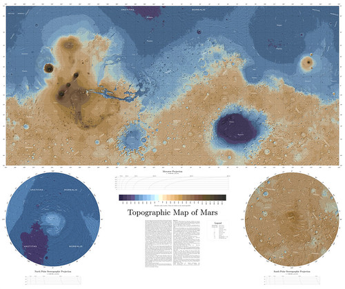
I've just published my new topographic map of Mars in Mercator and polar stereographic projections.
Basic info is directly in the map.
Map is available as 17 400 × 14 700 pix 78 MB jpeg via Flickr and as PDF with searchable text via Google Disc (106 MB!).
As always for big PDFs, I recommend Sumatra viewer.
Some other infos are on my blog but it's in Czech language.

Basic info is directly in the map.
Map is available as 17 400 × 14 700 pix 78 MB jpeg via Flickr and as PDF with searchable text via Google Disc (106 MB!).
As always for big PDFs, I recommend Sumatra viewer.
Some other infos are on my blog but it's in Czech language.
QUOTE (machi @ Nov 3 2014, 02:16 AM)
I've just published my new topographic map of Mars in Mercator and polar stereographic projections.
Basic info is directly in the map.
Basic info is directly in the map.
WOW ! WOW ! WOW ! What a MAP !!!!!!!!!!!
Thanks so much Machi for sharing this impressive work of yours.
Thank you so much again.
With warmest regards, VM
Very impressive work. And Google translate apparently does a relatively good job translating the Czech text into English - I think I was able to understand/interpret all of translated text.
You're welcome!
Google translate is very good for some languages in case of translating them to English and Czech is one of them ( I think ).
QUOTE (Bjorn Jonsson @ Nov 3 2014, 10:59 PM)
Very impressive work. And Google translate apparently does a relatively good job translating the Czech text into English - I think I was able to understand/interpret all of translated text.
Google translate is very good for some languages in case of translating them to English and Czech is one of them ( I think
).
New version of my topographic map of Mars is now available.
This "Easter egg" version has high resolution (~ 100 m/pix) parts around most of the landing sites.
It works only as PDF so only this version is available. It has 116 MB and it needs good PDF viewer and
computer with enough power (tested with Sumatra, FOXIT, SMART viewer and 8GB RAM).
For an example here is part around Mars 3 landing site (located via HiView, longitude 202.01934056, latitude 45.0445105).
EDIT: Files are now with correct English abbreviation for Soviet Union.
QUOTE (machi @ Jan 26 2015, 12:21 AM)
.../... For an example here is part around Mars 3 landing site (located via HiView, longitude 202.01934056, latitude 45.0445105).
Dear Machi, thanks so much !!!!
Could you, please, be so kind to provide us also with the Mars 3 lander elevation ?
Thanks so much in advance and with warmest regards,
VM
You're welcome!
Closest measurement from MOLA gives 1626 meters, HRSC DEM with better coverage but with lower precision gives ~1660 meters.
Best guess based on published data 1655+/-30 meters. I suppose that I will add elevations for every identified lander in future version of the map.
BTW, according to HiView coordinates of Beagle 2 are 90.4303226,11.5270253. These are slightly different than values which Doug Ellison extracted from Google Earth (90.4295E 11.5265N). This very small difference gives location error ~500 meters. But I have no idea how precise HiView is but based on my experience with other landers I suppose
that Google is worse than HiView.
QUOTE (machi @ Jan 26 2015, 02:47 PM)
BTW, according to HiView coordinates of Beagle 2 are 90.4303226,11.5270253. These are slightly different than values which Doug Ellison extracted from Google Earth (90.4295E 11.5265N).
I pulled my values from HiView also...which is worrying.
QUOTE (machi @ Jan 26 2015, 11:47 PM)
You're welcome!
Closest measurement from MOLA gives 1626 meters, HRSC DEM with better coverage but with lower precision gives ~1660 meters.
Best guess based on published data 1655+/-30 meters. I suppose that I will add elevations for every identified lander in future version of the map.
BTW, according to HiView coordinates of Beagle 2 are 90.4303226,11.5270253. These are slightly different than values which Doug Ellison extracted from Google Earth (90.4295E 11.5265N). This very small difference gives location error ~500 meters. But I have no idea how precise HiView is but based on my experience with other landers I suppose
that Google is worse than HiView.
Closest measurement from MOLA gives 1626 meters, HRSC DEM with better coverage but with lower precision gives ~1660 meters.
Best guess based on published data 1655+/-30 meters. I suppose that I will add elevations for every identified lander in future version of the map.
BTW, according to HiView coordinates of Beagle 2 are 90.4303226,11.5270253. These are slightly different than values which Doug Ellison extracted from Google Earth (90.4295E 11.5265N). This very small difference gives location error ~500 meters. But I have no idea how precise HiView is but based on my experience with other landers I suppose
that Google is worse than HiView.
Thanks a lot Machi !
QUOTE (djellison @ Jan 26 2015, 11:51 PM)
I pulled my values from HiView also...which is worrying.
From which image? I've used ESP_037145_1915.
I tried to extract location again in full resolution and it gives me 90.43036115568,11.52698736394 or 90.43036543916,11.52698314553.
And I used wrong number in calculation so it's not error ~500 meters but only 50 meters. That's relatively negligible error.
My apology, as in previous version, I forgot Czech abbreviation of the Soviet Union in the map.
Now links leads to version with correct English abbreviation.
And I've added small new feature - the map has hidden word "outpost" which facilitates the searching for landing sites.
Now links leads to version with correct English abbreviation.
And I've added small new feature - the map has hidden word "outpost" which facilitates the searching for landing sites.
Updated version of my map with all official names up to date 14.1.2016.
Full resolution image has ~110MB and PDF has 117MB.
BTW, lowest place on Mars has finally official name - crater Badwater.
Full resolution image has ~110MB and PDF has 117MB.
BTW, lowest place on Mars has finally official name - crater Badwater.
[quote name='machi' date='Jan 15 2016, 03:12 AM' post='229048']
Updated version of my map with all official names up to date 14.1.2016.
What an INCREDIBLE work !!!!! Thanks a lot Machi !
Updated version of my map with all official names up to date 14.1.2016.
What an INCREDIBLE work !!!!! Thanks a lot Machi !
Interesting to match Machi's stunning topographical map with the just completed Gravity and crustal thickness maps.
http://mars.nasa.gov/mro/news/whatsnew/ind...amp;NewsID=1899
http://mars.nasa.gov/mro/news/whatsnew/ind...amp;NewsID=1899
what a nice photos 
QUOTE (Rain @ Nov 28 2018, 02:36 AM)
HiRISE DEMs are available here: https://www.uahirise.org/dtm/ Keep in mind that the corner coordinates can be of by quite a bit.
Paolo
I am currently doing some Mars cartography work and just realised that Spirit and Opportunity tracks in Mars2000 Sphere projection published at Analyst's Notebook don't align with Google Earth kml based data and vice versa. Does anyone have any idea which projection is used to display Google Mars data, as it does not seem to use standard GSC/WGS84? Thank you.
I don't know, but I looked at the traverse map in Analysts Notebook and it matches the background map properly. That map is in a cylindrical projection. It might be that cylindrical projection data have been mapped straight onto the GE globe without correction.
Phil
Phil
QUOTE (Rain @ Nov 28 2018, 11:36 AM)
Sorry for late reply,
you can download global DEMs from MOLA altimeter here: http://pds-geosciences.wustl.edu/missions/mgs/megdr.html
There is also combined MOLA/HRSC DEM here but for now server is down thanks to US budget shutdown.
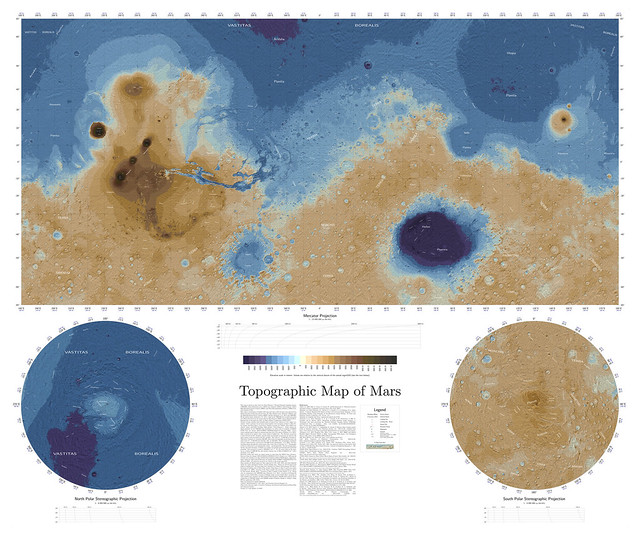
New version (1.2) of my Topographic Map of Mars.
It contains all official names up to end of year 2018 but main difference between this version and the previous one is new base map with higher resolution
so now map shows almost twice as much details.
There are also new mini scale bars directly in the map so estimating size of surface features is now much easier when browsing at full resolution.
PDF version (171 MB!) contains on top of that more detailed regional maps of most of the landing sites including some future ones (Jezero crater and Oxia Planum).
More detailed description of changes is on my blog (in Czech language but there is a Google translate button on the page).
[quote name='machi' date='Jan 9 2019, 10:45 PM' post='243339']
What a feat ! Congratulations Machi for this outstanding work
Btw, about the deepest point in Hellas, which figure you would recommend for EPO purposes, please : the one derived from MOLA or the one from HRSC ?
What a feat ! Congratulations Machi for this outstanding work
Btw, about the deepest point in Hellas, which figure you would recommend for EPO purposes, please : the one derived from MOLA or the one from HRSC ?
Thank you!
I would recommend HRSC result. MOLA result is in this case affected by lack of coverage as it clearly missed the lowest point.
It's a pity that MOLA suffered fatal malfunction long before MGS' end of mission. We could have better coverage of the Martian surface by the laser altimetry.
I would recommend HRSC result. MOLA result is in this case affected by lack of coverage as it clearly missed the lowest point.
It's a pity that MOLA suffered fatal malfunction long before MGS' end of mission. We could have better coverage of the Martian surface by the laser altimetry.
QUOTE (machi @ Jan 11 2019, 02:38 AM)
Thank you! I would recommend HRSC result. MOLA result is in this case affected by lack of coverage as it clearly missed the lowest point.
It's a pity that MOLA suffered fatal malfunction long before MGS' end of mission. We could have better coverage of the Martian surface by the laser altimetry.
It's a pity that MOLA suffered fatal malfunction long before MGS' end of mission. We could have better coverage of the Martian surface by the laser altimetry.
Dear Machi, Thank you very much for your kind answer
QUOTE (Phil Stooke @ Jan 9 2019, 05:58 AM)
I don't know, but I looked at the traverse map in Analysts Notebook and it matches the background map properly. That map is in a cylindrical projection. It might be that cylindrical projection data have been mapped straight onto the GE globe without correction.
Phil
Phil
First of all, thank you Phil very much for your attention, I was really hoping for your answer.
Yes, the Analyst's track aligns perfectly with HiRISE imagery as well as with stereo DTM's in Equirectengular Cylindrical Projection using Mars2000 sphere. What does not align are Opportunity tracks (and other Mars data) I originaly got in KML format. The first picture illustrates the point. Even when the track is reprojected from basic WGS84 to Mars2000 sphere datum, KML track still won't align.
And vice versa. When I load SHP Analyst's track into GE Mars, it is off by about 200 meters (second picture), but all KML based data aligns nicely.
It appears to me the problem lies with the the fact the apparently unknown datum other than WGS84 or Mars2000 Sphere is used by Google Mars, and so the transformation does not work out.
For Curiosty rover I only have Fernando Nogal's excellent track in KML and am not sure how well it aligns when reprojected onto EC Mars2000 Sphere map
Is it in the right place or is off by the same amount as the other KML Mars data?
Thank you in advance, Jack
This is a "lo-fi" version of our main content. To view the full version with more information, formatting and images, please click here.