djellison
Dec 24 2005, 06:15 PM
New SS Update -
"December 23, 2005
Things have been going well at Gusev. We've spent most of the past week looking at a rock right next to Comanche that we call Comanche Spur. Like everything we've seen since we've descended off of Haskin Ridge, Comanche Spur has undergone very little alteration and has a lot of olivine in it. But the composition is different from what we saw at Seminole and Algonquin, so we seem to have yet another rock type at Gusev.
With the Comanche campaign wrapping up, it was decision time... Allegeny Ridge or El Dorado? We had a long meeting about that at mid-week, and the consensus decision was to head for El Dorado. We should begin the drive on about Sol 704, and we're hoping it will go quickly. Expect Spirit to do a lot of driving and (except at El Dorado) not much IDD work in the weeks ahead...."704 is Boxing Day

What do you think - El Dorado for New Year with a nice 6 x 3 pancam postcard....go on Jim, you know you want to

Doug
edstrick
Dec 25 2005, 07:11 AM
I keep waiting for somebody who's had a few nachos too many to refer to the next target as "el Dorito", and then somebody to get inventive with Photoshop...
dvandorn
Dec 25 2005, 08:18 AM
Ah, the basal geology now becomes apparent. Home Plate isn't an ancient, eroded crater remnant -- it's a salsa bowl!
-the other Doug
ustrax
Dec 26 2005, 12:20 PM
QUOTE (djellison @ Dec 24 2005, 06:15 PM)
New SS Update -
"December 23, 2005
We had a long meeting about that at mid-week, and the consensus decision was to head for El Dorado."And wasn't that the best Xmas gift I could have this year?
Yes yes it was...

Toma B
Dec 26 2005, 03:41 PM
QUOTE
From S.S. update:
...We should begin the drive on about Sol 704, and we're hoping it will go quickly. Expect Spirit to do a lot of driving and (except at El Dorado) not much IDD work in the weeks ahead...."
Looks like that long drives started...
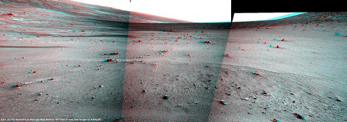
Click to view attachmentClick to view attachmentIs that Commanche rear hazcams view?
Bill Harris
Dec 26 2005, 04:24 PM
Seems to be. Here is a current NavCam showing Eldorado without Comanche in the way...
--Bill
Toma B
Dec 26 2005, 05:16 PM
O.K.
There are few
new pictures at exploratorium including this one showing Commanche behind...
Click to view attachment
edstrick
Dec 27 2005, 08:57 AM
Dvandorn: "Ah, the basal geology now becomes apparent. Home Plate isn't an ancient, eroded crater remnant -- it's a salsa bowl!"
Unfortunately, Spirit isn't instrumented for Guacamole!
ustrax
Dec 27 2005, 10:45 AM
Spirit drived a lot...It stopped at about...1/3 of the way to El Dorado?
It wouldn't surprise if when today images arrive we were facing the Undae...
ustrax
Dec 27 2005, 02:50 PM
QUOTE (ustrax @ Dec 27 2005, 10:45 AM)
Spirit drived a lot...It stopped at about...1/3 of the way to El Dorado?
It wouldn't surprise if when today images arrive we were facing the Undae...
One more stretch and...
http://qt.exploratorium.edu/mars/spirit/na...SRP0755L0M1.JPGThis was the Sol Spirit crossed the border between light and shadow...We are now in Ultreya ground...
I'm happy!
Isn't all that sand a beauty?...
http://qt.exploratorium.edu/mars/spirit/pa...SRP2427L7M1.JPG
Burmese
Dec 27 2005, 02:51 PM
Now can they resist the urge to stop at that outcrop between Spirit's current position and El Dorado and just keep on driving?
ustrax
Dec 27 2005, 02:55 PM
QUOTE (Burmese @ Dec 27 2005, 02:51 PM)
Now can they resist the urge to stop at that outcrop between Spirit's current position and El Dorado and just keep on driving?
I believe it will be a non-stop driving till El Dorado...
sattrackpro
Dec 27 2005, 02:56 PM
QUOTE (ustrax @ Dec 27 2005, 03:45 AM)
Spirit drived a lot...It stopped at about...1/3 of the way to El Dorado?
It wouldn't surprise if when today images arrive we were facing the Undae...
As of 12/17/2005 posting on exploatorium it looks like the dunes of El Dorado are no more than a few feet away.
2N188959784EFFAKSRP0755L0M1.JPG
ustrax
Dec 27 2005, 03:15 PM
mhoward
Dec 27 2005, 04:03 PM
Sol 705
Toma B
Dec 27 2005, 04:09 PM
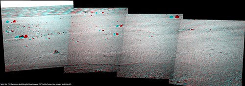
Quick stich in Autostich....Ultreya, El Dorado whatever...
 Click to view attachment
kanalje
Dec 27 2005, 09:55 PM
Well, this is looking like it could be plenty fun, this!
Marz
Dec 27 2005, 10:00 PM
QUOTE (ustrax @ Dec 27 2005, 09:15 AM)
Wow! The Other Face of Mars!

Nice to see Spirit breaking new ground!
Tesheiner
Dec 27 2005, 10:25 PM
Parallax measurements for sol 704 and 705 drives give me about 50m on each sol.
BTW, I posted an updated route map on its respective thread.
Oersted
Dec 27 2005, 11:52 PM
Maybe the team is hoping for a cleaning event near El Dorado, could be a golden opportunity for that, if the dune field is a sign of a windy area. Would it be? Or would it rather be the opposite?
This is my first Spirit-board posting btw, greetings all, I'm a Rover nut from Denmark!
Bob Shaw
Dec 28 2005, 12:38 AM
I suspect that Eldorado will - for reasons of Rover safety - be given a fairly wide berth. It looks rather like the sort of classic rover trap we've seen before, and hardly worth attention if Home Plate (and beyond) is to be reached.
BUT...
...Eldorado *does* provide a great opportunity (oops) for some crater counting. If Gusev has anything like the number of mini-craters which we've seen on the other side of Mars, then it really suggests an aerial origin for the wee holes - and, if not, it suggests that something under the surface is responsible. Eldorado is the first Meridiani-like bit of Gusev we've seen...
Bob Shaw
DFinfrock
Dec 28 2005, 02:44 AM
QUOTE (Bob Shaw @ Dec 28 2005, 12:38 AM)
I suspect that Eldorado will - for reasons of Rover safety - be given a fairly wide berth. It looks rather like the sort of classic rover trap we've seen before, and hardly worth attention if Home Plate (and beyond) is to be reached.
Bob Shaw
It looks to me that there is such a sharp edge to the dune/ripple field, that it should be no problem to drive right up to the first ripple, extend the arm, and examine it closely, without actually placing a wheel into the sand itself.
David
mhoward
Dec 28 2005, 03:07 AM
dot.dk
Dec 28 2005, 08:40 AM
QUOTE (Oersted @ Dec 27 2005, 11:52 PM)
This is my first Spirit-board posting btw, greetings all, I'm a Rover nut from Denmark!
About time we got some more Great Danes in here!


Welcome aboard
Tman
Dec 28 2005, 12:03 PM
http://home.shinternet.ch/gp/spirit/2P1885...6-89L456_av.jpg (RGB from sol 701, only brightness increased)
That's really odd. If we have here a gathering place of fine sand particles, why this change in color?
Welcome Oersted!
dvandorn
Dec 28 2005, 12:08 PM
Yeah -- unlike some of the other dark spots in the orbital imagery, this (and other black-sand deposits like it) truly appear as dark from the surface as they do from orbit.
I would *have* to think that there is some major compositional difference between the dark sands and the surrounding rocks and soils, to account for the dramatically darker appearance. The fact that the dark sand patches seem to be in the wind shadows of the hills *seems* to explain them as dust fall-out from prevailing winds -- but that then begs the question as to why there should be a major compositional difference between the particles that fall out in such conditions and the particles that have been wind-deposited into the surrounding soils.
-the other Doug
djellison
Dec 28 2005, 12:09 PM
I dont think it is fine particles. I imagine it is sand, darker basaltic sand. The lighter coloured, beigey dust remaining suspended in the air while darker particles get dropped as the wind stalls over the hill
Doug
edstrick
Dec 28 2005, 12:35 PM
There is a lot of really not-understood sorting and mixing processes of "dusts", "sands" and "composit particles" on Mars. The only reasonably well understood material in fact may be the dark sands of places like el Dorito\\\\\\Dorado, because well sorted clean mineral-grain sands are relatively uncomplicated and well understood. Sorting may be both mechanical and electrostatic, grains of dust can aggregate and aggegrates can break up, etc. I simply do not understand a lot of the subtle but complex color variations on soils and rocks due to dust and sands and who-knows that I've been seeing since the first Viking pictures.
David
Dec 28 2005, 01:18 PM
Is the color-contrast seen at El Dorado similar, though on a smaller scale, to the large-scale albedo differences that have been observed on Mars for centuries? If so, it would be of considerable interest to examine the properties of the darker sand, and -- if Spirit keeps El Dorado in view for some time -- to watch for any changes in its distribution over time.
Tman
Dec 28 2005, 01:21 PM
When I have a look at this
mosaics from Nico, I get too the impression that this dark sand is a deposit of heavier particels when wind comes (from (north-) west I guess) over the hills and blows down material from them. So the lighter material blows farther than the heavier.
Maybe it's also an electrostatic process that the heavier particles get aggregate together when flying...?
ustrax
Dec 28 2005, 01:49 PM
I see it like this, winds coming from SE, bringing lighter particles and volcanic sand, climbing the slope.
In the place where now we see the dark sand, there is a wall on the western side keeping the volcanic sand imprisioned but letting the lighter particles follow their way, following the direction of the winds, quoting Steve Squyres, an 'eolian cul-de-sac'.
So, if analyzing that El Dorado dark deposits, it wouldn't surprise that Spirit would find mainly micro basaltic pieces, crystals and lots of olivine, the composition of volcanic sand.
Well, just a guess...
djellison
Dec 28 2005, 01:51 PM
The prevailing wind is from the NNW however, look at all the DD tracks crossing Gusev Crater
http://www.msss.com/mars_images/moc/2004/0...02.R1101577.jpgDoug
ustrax
Dec 28 2005, 02:05 PM
QUOTE (djellison @ Dec 28 2005, 01:51 PM)
The prevailing wind is from the NNW however, look at all the DD tracks crossing Gusev Crater
http://www.msss.com/mars_images/moc/2004/0...02.R1101577.jpgDoug
Yes Doug I know...But I find strange that if the sand was being brought from NNW then we would see dark material in a wider area right under the summits...And we see it only in that hill corner...
And Steve Squyres, on a question I made, answered that the El Dorado material had 'probably just climbed a hill slope'...
Soon we'll have more answers...
ustrax
Dec 28 2005, 02:08 PM
Just forgot this, talking about volcanic sand patterns:
http://www.edgypix.com/pages/torf0706.shtmlHave some similarities, doesn't it?
helvick
Dec 28 2005, 02:22 PM
QUOTE (ustrax @ Dec 28 2005, 03:05 PM)
Yes Doug I know...But I find strange that if the sand was being brought from NNW then we would see dark material in a wider area right under the summits...And we see it only in that hill corner...
I think we are talking about two different seasonal wind systems. I know nothing about the prevailing winds in Gusev but I'm pretty sure there are global changes in the average wind direction between Southern Hemisphere Summer (DD Season, NNW tracks) and winter (SSW would make sense but the local geography might seriously change that and the overall impact of the martian global weather system most certainly creates trade wind bands which might reverse these).
This is just my gut feel for the thing, SH Winter, polar regions cool substantially and pressure rises leading to predominantly Southerly wind (source) directions and this would reverse in NH winter. The global imbalance in Martian seasons would play an important role as the SH Winter effects are less extreme and shorter.
ustrax
Dec 28 2005, 02:26 PM
QUOTE (ustrax @ Dec 28 2005, 02:08 PM)
Just forgot this, talking about volcanic sand patterns:
http://www.edgypix.com/pages/torf0706.shtmlHave some similarities, doesn't it?
Let's see if you can understand what I'm trying to say...
I think that the volcanic sand was trapped in a depression (not-an-abyss!) existing between the western wall and where now lays the boundary between the light and dark material (in reddish tone), brought from winds (direction indicated by the arrows) from the floor of the basin...
The area covered by light material (in brownish tones) worked as a road to perdition to that poor dark sand.
http://img.photobucket.com/albums/v352/ustrax/pw.jpg
RNeuhaus
Dec 28 2005, 02:36 PM
QUOTE (ustrax @ Dec 28 2005, 09:05 AM)
Yes Doug I know...But I find strange that if the sand was being brought from NNW then we would see dark material in a wider area right under the summits...And we see it only in that hill corner...
And Steve Squyres, on a question I made, answered that the El Dorado material had 'probably just climbed a hill slope'...
Soon we'll have more answers...
Hello, the answer will be by looking the formation of dunes. The dunes always forms in perpendicular angle to the prevailing winds. Very soon we are going to confirm about this whenever Sprit takes a much better view and angle picture. Up to now, there are still no good pictures to see about this.
Rodolfo
Bill Harris
Dec 28 2005, 02:53 PM
QUOTE
The dunes always forms in perpendicular angle to the prevailing winds.
Not always. This is true with transverse dunes, but not with longitudinal or reversing dunes.
I think that the answer will be complex. Is this area the result of selective winnowing or deposition of the dark sand because of a unique wind pattern caused by orographic effects, or is it caused because the source material for the sand is _at_ this location, or both? We need MIs of the sand, and minerology.
Note other "dark sand" examples in the Northeast Basin and another spot to the south of the Inner Basin. Start picking up clues: from the current route, what is the local wind direction?
--Bill
Bob Shaw
Dec 28 2005, 03:33 PM
QUOTE (DFinfrock @ Dec 28 2005, 03:44 AM)
It looks to me that there is such a sharp edge to the dune/ripple field, that it should be no problem to drive right up to the first ripple, extend the arm, and examine it closely, without actually placing a wheel into the sand itself.
David
David:
Very true!
And, returning to the subject of the holes which Opportunity has seen, it'd be an ideal way for that counting exercise. I've also had another bright idea - this time, perhaps in the Ted Stryk / Phil Stooke Department of Old Data: Viking 1 saw some drifts, which Ted has turned into super-res images on his website. I can't see any, but has anyone else spotted any holes? If they're not visible at Gusev when we see El Dorado up close, possibly not visible at Chryse in old images BUT visible at Meridiani then we're seeing either a 'special' impact event (which I'd be leery of, though obviously it might happen) or something inherent in the Meridiani environment...
Ted's website is at:
http://pages.preferred.com/~tedstryk/Bob Shaw
antoniseb
Dec 28 2005, 04:09 PM
QUOTE (Bob Shaw @ Dec 28 2005, 10:33 AM)
If they're not visible at Gusev when we see El Dorado up close, possibly not visible at Chryse in old images BUT visible at Meridiani then we're seeing either a 'special' impact event (which I'd be leery of, though obviously it might happen) or something inherent in the Meridiani environment...
It's worth trying to count them per square meter. We've seen images of a lot of square meters of dust-piles at Meridiani, and not nearly so many at Gusev, no mater whether we look at ALL of El Dorado or not. If the images from Chryse show even one, it will be a lucky chance.
ustrax
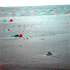
Dec 28 2005, 04:23 PM
ustrax
Dec 28 2005, 04:41 PM
dot.dk
Dec 28 2005, 04:50 PM
WOW!!!

That IS amazing!! Looks greeeeeat!
This is a great end to 2005! Happy New Year!
dot.dk
Dec 28 2005, 04:51 PM
ustrax
Dec 28 2005, 04:54 PM
QUOTE (dot.dk @ Dec 28 2005, 04:51 PM)
LOOK at that!

Wasn't it supposed to stay just at the 'shore'?
Spirit just couldn't resist to refresh her wheels...
http://qt.exploratorium.edu/mars/spirit/na...00P0775L0M1.JPGDon't swim to far away honey!

Tesheiner
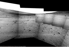
Dec 28 2005, 05:00 PM
The full 360º navcam panorama.
Click to view attachment (390k)
PD: Where are the beers?
helvick
Dec 28 2005, 05:08 PM
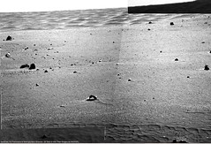
Anybody else able to see qualitative differences in the material wrt Meridiani and in the other sand traps we saw on the south side o' the hill? Contrary to my expectation this seems to be very fine dust that slumps very easily rather than larger grains but I presume we'll need to see some MI's before making any claims about that.
ustrax
Dec 28 2005, 05:09 PM
QUOTE (Tesheiner @ Dec 28 2005, 05:00 PM)
The full 360º navcam panorama.
PD: Where are the beers?
I've got one already!
We all deserve one!!!
Hey doesn't this sound like a POOOF!?
http://qt.exploratorium.edu/mars/spirit/na...00P1975L0M1.JPG
jabe
Dec 28 2005, 05:10 PM
you guys are toooo fast

was going to say the images are here but a pan is already up...
looks enticing..
mhoward
Dec 28 2005, 05:18 PM
Yeah, what was somebody saying about just skirting the edge?
This place looks a bit surreal!
Some additional quick views (more at the Flickr site):


This is a "lo-fi" version of our main content. To view the full version with more information, formatting and images, please
click here.