Help - Search - Members - Calendar
Full Version: To El Dorado...
Unmanned Spaceflight.com > Mars & Missions > Past and Future > MER > Spirit
Pages: 1, 2, 3, 4, 5
RNeuhaus
Brahma beer must be inside of El Dorado biggrin.gif So Spirit must dig looking for that!

Rodolfo
RNeuhaus
QUOTE (helvick @ Dec 28 2005, 12:08 PM)
Anybody else able to see qualitative differences in the material wrt Meridiani and in the other sand traps we saw on the south side o' the hill? Contrary to my expectation this seems to be very fine dust that slumps very easily rather than larger grains but I presume we'll need to see some MI's before making any claims about that.
*

Indeed yes, the sand is a fine grain and it is generaly very compact and it is much better for traction than a thick sand that is generally is looser than a fine ones which is found in the Meridiani Planum where Opportunity was sunk.

The prominent wind comes from the north west. The wind coming from the north strikes the Husband Hill and continues blowing around this hill. There are two sizes of ripples: bigger and smaller. Both have different angles. The biggest ripples are run from the hill to base in more or less parallel lines and the smaller ripples are build by soft winds comming from North West and runs in 150 angle degree ( \| )from the biggest ripples running from Hill to base.

Rodolfo

P.D. Hope for MI to see if there are dust.
Burmese
Spirit scooted several meters right into the stuff! I wonder if they just felt brave and cranked up the slip sensitivity level and told her to go at it.
djellison
A full NC mosaic instead of a partial + few L7/R1 PC frames suggests that this is

- a new 'site'
- somewhere they instead to camp for a few days

But...umm..yeah, we're here smile.gif

Doug
silylene
QUOTE (RNeuhaus @ Dec 28 2005, 05:19 PM)
Indeed yes, the sand is a fine grain and it is generaly very compact and it is much better for traction than a thick sand that is generally is looser than a fine ones which is found in the Meridiani Planum where Opportunity was sunk.


No microcraters. Odd. With the frequency we saw them at Meridiani, we should've seen a few by now.
djellison
No microcraters suggests, one presumes at the macro scale as well as the planetary scale, that it is a younger surface -and that aeolian activity at Meridiani is a much slower process than here at El Dorado

Doug
silylene
QUOTE (silylene @ Dec 28 2005, 05:59 PM)
No microcraters.  Odd.  With the frequency we saw them at Meridiani, we should've seen a few by now.
*


Agreed, that is the most likely explanation. How do the frequency of dustdevils compare between the two locations?
mars loon
QUOTE (Burmese @ Dec 28 2005, 05:53 PM)
Spirit scooted several meters right into the stuff!  I wonder if they just felt brave and cranked up the slip sensitivity level and told her to go at it.
*

This is amazing and surreal.

Truly deserving of "Unlike anything ....."

As the "blue collar" rover twin, Spirit is absolutely fearless !!
Bill Harris
That was quick. I'm speechless.

The "dark sand" material seems to be less cohesive than the Meridiani sand. The surface seems "fresher" and more wind-blown, which may be a side-effect of not having the protective blueberry pavement. The wind direction seems to be quite variable and the wind seems turbulent, as suggested by the ripple patterns.

Wow. Strange stuff. We'll know more soon-- she dug a trench and is likely unfurling the IDD as we type.

--Bill
Shaka
YEEEEEEE HAAAAAA!!!!
laugh.gif laugh.gif

Com'on in everybody! The sand is FINE!

"OH, Over The Mountains of the MOOOON
Down the Valley of Shaaadowww
RIDE, BOLDLY RIDE!!!!

Last one to the other SIDE!!! laugh.gif biggrin.gif tongue.gif laugh.gif biggrin.gif
ToSeek
QUOTE (Burmese @ Dec 28 2005, 05:53 PM)
Spirit scooted several meters right into the stuff!  I wonder if they just felt brave and cranked up the slip sensitivity level and told her to go at it.
*


Either that, or some rover operator is going "oops!" about now. wink.gif
Tesheiner
Looking uphill, the interface between the dunes to the left -- they look like powder -- and the "normal" terrain to the right can be easily identified.

The question is why this abrupt interface?
Tesheiner
QUOTE (RNeuhaus @ Dec 28 2005, 06:19 PM)
Brahma beer must be inside of El Dorado  biggrin.gif  So Spirit must dig looking for that!

Rodolfo
*


OT: Do you know how many years since my last Brahma?
Tman
biggrin.gif

wink.gif But such "oops!" would be probably his/her last word as operator...


QUOTE (Bill Harris @ Dec 28 2005, 08:26 PM)
The "dark sand" material seems to be less cohesive than the Meridiani sand. The surface seems "fresher" and more wind-blown

Yea, and it seems the fine material is only a few centimeters thick and lies directly over the hard ground of this hill side.
Burmese
The twitchy track Spirit left entering the dunes suggest she was on autopilot, not a commanded drive. They probably had her start advancing cautiously on auto pilot a meter or so before the dunes and she went the maximum distance permitted by her instructions without any aborted stops, then finished with a turn to maximize communications.
RNeuhaus
QUOTE (Tesheiner @ Dec 28 2005, 03:28 PM)
Looking uphill, the interface between the dunes to the left -- they look like powder -- and the "normal" terrain to the right can be easily identified.

The question is why this abrupt interface?
*

The limit line between two different morphology terrain is caused by the aeolian factor. That is strange line but this limit is not black and white rather than a gradual change of morphology. After the line, the terrain is plain is where there is no much wind to form ripples.
QUOTE (Tesheiner @ Dec 28 2005, 03:33 PM)
OT: Do you know how many years since my last Brahma?

No one idea. I suspect that you missed it much, so your last drinking time might be few years ago? If not drinking, perhaps, you might have bought it in any supermarket around in Spain. It is so good that after drinking one, ones starts to brama wink.gif (dance wildely)

What does O.T. mean? (One Tought?)

Rodolfo
RNeuhaus
QUOTE (Bill Harris @ Dec 28 2005, 02:26 PM)
The "dark sand" material seems to be less cohesive than the Meridiani sand. 
*

http://www.flickr.com/photo_zoom.gne?id=78537312&size=l
It is not certain. You can see the Spirit tracks which is less deep than ones of Meridiani when Oppy traveled over ripples. Of course, on paved bluberries is more compact but the Meridiani ripples are looser.
QUOTE (Bill Harris @ Dec 28 2005, 02:26 PM)
The surface seems "fresher" and more wind-blown, which may be a side-effect of not having the protective blueberry pavement. 
*

I agree it.
QUOTE (Bill Harris @ Dec 28 2005, 02:26 PM)
The wind direction seems to be quite variable and the wind seems turbulent, as suggested by the ripple patterns.
*

Not much turbulent since there are two types of ripples: small and large. If there are turbulent, then there won't have any ripples since the turbulent wind will sweep all sides like a broom. Otherwise, the small ripples is more or less alineated in parallel line but but different line to the larger ripples. Among large ripples are more or less in parallel line.

Rodolfo
RNeuhaus
Click to view attachment
The sand is so fine and compact. Very different than ones of Meridiani Planum which is grainer and loose. I am comparing it with ones on the top of ripples. It would be very nice to submerge ithe black sand since it shall be warmer than the outside. They must be lighter and softer and must be the result of aeolian factor.

After that, will Spirit head toward the Aleghaney (not sure about its spelling but it looks almost alike) or Home Plate?

Rodolfo
CosmicRocker
It's always so fun to see something new. I was trying to guess the prevailing (average) wind direction at this location, after being asked about it by a friend. Sometimes it is obvious, but sometimes these Martian ripples confuse me.

One would normally expect that the windblown grains are pushed up a gentler slope, collect temporarily at the crest, and then cascade down the steeper slip slope on the leeward side, when the angle of repose is exceeded. Assuming that the steeper slopes of the ripples should be the leeward ones, it would appear that the prevailing wind is coming up the valley, roughly from the west. Could dust devils rounding the corner from the plains have a role in the formation of these dark deposits?

It sure would be nice to know something about the composition/density of these grains. We'll probably see some MIs, but how long might it be before someone leaks some information from the spectrometers?
Phil Stooke
Here is Tesheiner's nice pan in polar projection.

Phil

Click to view attachment
Bill Harris
Thanks, Phil, I've been waiting for one of your polars.

I'm confused by these duneforms and the suggested wind directions. It seems to be coming from every which a-way and is not the usual neat laminar flows we are accustomed to. What I'm thinking is that the topography causes the wind to "swirl" and create a "vortex" over El Dorado.

Yeah, a Vortex. Right.

It's too late... biggrin.gif

--Bill
abalone
QUOTE (Phil Stooke @ Dec 29 2005, 06:16 PM)
Here is Tesheiner's nice pan in polar projection.

Phil

Click to view attachment
*

I dont often comment on photos....

....... but that's spectacular smile.gif smile.gif smile.gif
abalone
QUOTE (Bill Harris @ Dec 29 2005, 08:16 PM)
Thanks, Phil, I've been waiting for one of your polars.

I'm confused by these duneforms and the suggested wind directions.  It seems to be coming from every which a-way and is not the usual neat laminar flows we are accustomed to.  What I'm thinking is that the topography causes the wind to "swirl" and create a "vortex" over El Dorado. 

Yeah, a Vortex.

It's too late...  biggrin.gif

--Bill
*

I suggested a while ago in another thread that these dark patches and on slopes facing the summer sun seem to be the places that many DDs originate so I agree with you that this might be the case
Bill Harris
Here is a .pdf of a paper on "Transverse Aeolian Ridges" which is relevant to what we see at El Dorado. Sorry, I've misplaced the source URL.

--Bill
ustrax
QUOTE (Bill Harris @ Dec 29 2005, 09:16 AM)
Thanks, Phil, I've been waiting for one of your polars.

I'm confused by these duneforms and the suggested wind directions.  It seems to be coming from every which a-way and is not the usual neat laminar flows we are accustomed to.  What I'm thinking is that the topography causes the wind to "swirl" and create a "vortex" over El Dorado. 

--Bill
*


A vortex?...Curious...When I first thought and wrote something about Ultreya, on the distant 3rd of April, 2004, my idea, looking at the satellite images was around that... A spiral...
A bit of Ultreya archeology... smile.gif :

'Then I went to the bathroom and when I was taking a pee [?!] something caught my attention: the path followed by the liquid in the toilette inclination: it reached the wall, made a spiral from the hit spot to right and then to left and finally down the drain?
Something hit me?What if the Ultreya Abyss worked has the toilette?
If it did there must be a path leading to the crater and another one to drain the water out, not down the toilette but back to the supposed Gusev Lake. Checking the available images I could say it seems like this to me, those canals or sea arms are there.
The Ultreya Abyss was, for millions of years escavated by flowing water and, in my opinion has a minimum 100mts deep, and, has consequence of this movement sediments were deposited there in huge quantities.Resuming, Gusev was in fact a lake with tides, and the Ultreya Abyss worked as a crossroad of those waters, like a heart, receiving and releasing the waters, that at a time, entered the crater coming from the MA'Adim Valley.'


Well...No abyss, but it was quite a journey... biggrin.gif
djellison
From the pancam site, it looks like an MI mosaic, then the Mossbauer onto the sand, with some next-drive-direction-Pancam imaging ( one assumes slightly left of straight toward HP)

Doug
ustrax
QUOTE (djellison @ Dec 29 2005, 11:05 AM)
From the pancam site, it looks like an MI mosaic, then the Mossbauer onto the sand, with some next-drive-direction-Pancam imaging ( one assumes slightly left of straight toward HP)

Doug
*


Maybe there will be time to visit Allegheny...who knows?...The descent from El Dorado seems easy...

Now looking at some oldies...
Is it possible that sight we have now from the Ultreya area and the El Dorado dunes might not be permanent but seasonal?

http://www.zippyvideos.com/5077374292903756/u-ed/
ustrax
This criteria for naming places in Ultreya is just being a mystic delight... smile.gif
There is somewhere there a target called Seven Cities...
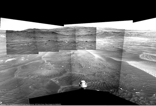
(706 11:41:12 p2534.15. 1 0 0 0 0 13 13 pancam_Seven_Cities_L234567Rall)
Utopias? I believe.

http://en.wikipedia.org/wiki/Antilia

'A Portuguese legend tells how the island was settled by the Archbishop of Porto accompanied by six bishops and their parishioners in either 714 or 734 in the face of the Moorish conquest of Iberia. The archbishop and bishops each founded a city, known as Aira, Anhuib, Ansalli, Ansesseli, Ansodi, Ansolli and Con. A similar Spanish tradition claims that these bishops were all Spanish. The Irish also have the very same tradition, which they ascribe to St Brendan, a real Irish saint to whom many such mythical feats are attributed.'

Now...This are great names to seed around the area... smile.gif

7 Cities, linked to a country of discoverers by legend on the 707th Spirit Sol...
What an experience for a guy from that same country who's birthday is on the 7th day of the 7th month, for my own sake I'm glad I'm not a numerologist... laugh.gif

Oh...One more...:

In Brief:

Marcos de Niza was the first explorer to report the Seven Cities of Cibola, and his report launched the Coronado expedition.

Marcos de Niza was a priest who was sent north from Mexico City by Viceroy Mendoza in 1538-39 to search for wealthy cities that were rumored to be somewhere north of the frontier of New Spain. In early 1539 he left the frontier at Compostela and journeyed north into the unknown for several months. In the summer of 1539 he returned and wrote a report saying he had discovered the cities – in a province called Cibola (the present-day native American pueblo of Zuni, New Mexico). He said he reached the first city and saw it from a distance, but because his companion had been killed there, he returned without entering it.

Most popular writers claim Marcos reported gold in Cibola, but his original report says nothing about gold. Nonetheless, conquistadors in Mexico city were exited by his news and assumed Cibola would be as wealthy as the conquered Aztec empire. Marcos led Coronado's army back to Cibola the next year, in 1540, but he became the scapegoat when Cibola turned out to have no gold, and the soldiers said he was a liar.

The big mystery about Marcos is whether he told the truth. Historians have argued for centuries about whether Marcos – a priest with a good reputation – simply interviewed some natives near the present border, and turned back without seeing Cibola. Also at issue: did he promote the rumors that Cibola was full of gold? Several prominent 20th century historians concluded Marcos did not have time to reach Cibola in 1539. They said he made up a fraudulent report as part of a conspiracy with Viceroy Mendoza to encourage the conquest of the north. Other historians have defended him.'

http://www.psi.edu/coronado/journeyofmarcosdeniza.html

Compostela...Ultreya and a fool had to appear somehow...
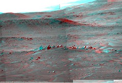
 laugh.gif
Bill Harris
No, no, no. Not that horsepucky.


By vortex I meant a persistent swirl or eddy in the airflow caused by orographic effects.

--Bill
ustrax
QUOTE (Bill Harris @ Dec 29 2005, 11:48 AM)
No, no, no. Not that horsepucky.

--Bill
*


It looks like you didn't receive this for Xmas...
http://www.arts.telegraph.co.uk/arts/main..../06/bomain.html
Tesheiner
QUOTE (RNeuhaus @ Dec 28 2005, 10:09 PM)
No one idea. I suspect that you missed it much, so your last drinking time might be few years ago? If not drinking, perhaps, you might have bought it in any supermarket around in Spain. It is so good that after drinking one, ones starts to brama  wink.gif  (dance wildely) 

What does O.T. mean? (One Tought?)

Rodolfo
*


I've never found Brazilian beer here in Spain.

OT = Off Topic. Anything that is not related to the thread.
ustrax
I'm a bit lost here...Are we already at the basin? Or beyond El Dorado?...:

http://qt.exploratorium.edu/mars/spirit/pancam/2005-12-29/
Burmese
I don't think they moved Just scanning the features to the south between current position and Home Plate but left and short of it.
ustrax
QUOTE (Burmese @ Dec 29 2005, 03:50 PM)
I don't think they moved  Just scanning the features to the south between current position and Home Plate but left and short of it.
*


Yes, South, but the features look really close to have been taken from the same location...Maybe a mega-panorama from there is on the way...
djellison
Very coarse grained stuff...

http://qt.exploratorium.edu/mars/spirit/mi...00P2937M2M1.JPG

Doug
mhoward
QUOTE (ustrax @ Dec 29 2005, 04:04 PM)
Yes, South, but the features look really close to have been taken from the same location...Maybe a mega-panorama from there is on the way...
*


No, they haven't moved, they're just looking south(ish), as Burmese said.


jabe
Will fine grain sands be underneath? Great sandbox for kids to play in but not for rovers... biggrin.gif
GregJG
I am not a geologist; but, the sharp El Dorado boundry demarkation and elevation bothers me. This looks to me more like a deposit from the weathering of a large central mass "crumbling" and flowing down and outward. Since there appear to be numerous similar deposits in the area (all on the southerly sides of local bluffs), could these have resulted from a relatively recent low elevation southerly desentigrating meteor(?) strike with large exposed chunks of this distinct material weathering into these "piles"? If the weathered particles were too coarse/heavy to be picked up by the prevailing winds, the localization and demarkation would persist and if relatively recent, the deposits would not yet be covered by the local dust. If not of meteoric origin, the masses could have been present in the hills and recently weathered out with the same result. Make any sense? Perhaps compositional analysis will tell.

Greg
Bill Harris
QUOTE
am not a geologist; but, the sharp El Dorado boundry demarkation and elevation bothers me. This looks to me more like a deposit from the weathering of a large central mass "crumbling" and flowing down and outward.


I am, and the morphology of this spot is bothersome. I can believe in wind deposition, but the boundary is remarkably sharp, and the material is being deposited on a slope and seems to be moving downslope. I'm leaning more and more in the direction of the source of dark sand being at the head of the slope.

"I think that the answer will be complex. Is this area the result of selective winnowing or deposition of the dark sand because of a unique wind pattern caused by orographic effects, or is it caused because the source material for the sand is _at_ this location, or both? We need MIs of the sand, and minerology."

Looking at the first MIs of the dark sand today, my first impression is that it looks very similar to the last MIs Spirit did at the dark rock at Comanche Spur. Are deeply weathered and crumbling outcrops of this material present at El Dorado, with the dark sand winnowed and concentrated by unique aeolian conditions?

This is indeed an odd area.

--Bill
Bill Harris
Here is a 1x2 mosaic of two of the MI images from Spirit today. I think that I have it oriented correctly, although I have no idea exactly where this spot is located in today's hazcam view.

The upper part of this pan is the undisturbed ripple surface, the dark slope is the cut from the rover wheel and the material in the lower part is sand churned by the wheel.

--Bill
dvandorn
QUOTE (Bill Harris @ Dec 29 2005, 12:38 PM)
...Are deeply weathered and crumbling outcrops of this material present at El Dorado, with the dark sand winnowed and concentrated by unique aeolian conditions?
*

I posted this idea quite a while back, somewhere in the many, many posts I've made at this forum. I fear it would take hours for me to try and fine it, so I'll just re-state it.

I had been looking at the orbital imagery and commented that I thought I saw a series of bench-like outcrops along the side of the hill that seemed to border the upslope side of the dark-material field. It looked to me like the benches could be the source of the dark material, since they seemed to be just as dark as the rest of the field. I was arguing that this seemed to be unique material -- much, much darker and less red than everything around it (which, we now see, it surely is).

I proposed that the dark beds could be the eroded remnants of a layer of lacustrine materials, uplfted at the base of the hills. And I thought that made what has now been named El Dorado a prime target for investigation.

I may be wrong about the lacustrine origin, but I'm surely glad we're checking it out! I would also hope that a mini-TES from this spot would be able to characterize the outctops we *do* see at the far extent of the dark sand field as either the source of the dark sand, or definitely *not* its source.

In any event, we need a decent shot at the mineralogy here, to constrain any assumptions on the origin of these sands. Until we get that, this discussion is pretty much in the energetic-arm-waving phase.

However it comes out, this is a very exciting process!

-the other Doug
CosmicRocker
The individual grains are quite well rounded, which would argue for them having travelled quite a distance and for a long time, unless they were already well rounded before eroding from an outcrop that is nearby. The former is more likely.

I think these could be the transverse aeolian ridges mentioned by Bill, but those come in several flavors as described in the attached paper. If this classification is still in vogue, these appear to be TARs of the "networked" variety. Bourke et al mention the following with regard to that type of TAR:

"Network: Networked ridges in troughs on Mars tend to
form in local topographic lows and areas of secondary
flow circulation. They are closely spaced and appear
to be smaller than the other ridge types (Fig. 1e)."

Granted, they were studying aeolian ridges in the ubiquitous Martian troughs, but this doesn't seem to be too much of a stretch. They are similar to those seen in the bottom of Endurance. It is apparently downwind of the nearest local peak, and other aeolian bedforms in the vicinity seem to be converging on this area. It seems to be a convenient wind shadow in the average local flow that experiences fluctuations. In that light, it is not surprising that it's boundaries are fairly well defined. It looks like secondary flow, or as previously mentioned, something like a vortex.
Bill Harris
This is an exciting time and every day brings in new imagery for a new round of arm-waving. Exploratorium has more MIs from yestersol, as well as Hazcams and other images.

Now that Doug mentions it, I recall his comments about the dark area some time ago. Spirit's next stop ought to be those ledges upslope. Tom's paper is a good reference on duneforms.

Here is where she is sniffing...

--Bill
djellison
QUOTE (Me on the 24th)
What do you think - El Dorado for New Year with a nice 6 x 3 pancam postcard....go on Jim, you know you want to


"708 p2267.05 72 0 0 72 2 146 pancam_El_Dorado_pan_L257R2"

I presume that's a 6 x 3 - just what the doctor ordered smile.gif

MI images of the MB noseprint followed by an APXS integration on 709

Depending on the length of the APXS integ ( perhaps overnight? ) 710 could be a leaving-el-dorado day smile.gif


Doug
dot.dk
It is remarkable how productive Spirit is these days... How many targets have she investigated in the same time Oppy has been stuck at the same outcrop for over a month now?

Let's hope Oppy will bounce back soon with some kick ass driving biggrin.gif
jabe
latest pics are down..looking around at the dunes it seems..
ripples
djellison
I think it's a 9 x 2, not a 6 x 3 smile.gif I was close though tongue.gif

Doug
mhoward
Here's what's down so far (pretty false-color):


ustrax
Looking at the MI, and while the results don't arrive, the sand in El Dorado looks to be formed from different materials, is it possible to be, I'm repeating myself here, volcanic sand? And if the results indicate basalt and crystals, mainly olivine, and magnetic properties? Will this a definitive proof of it?

Compare this...

http://qt.exploratorium.edu/mars/spirit/mi...00P2977M2M1.JPG

With this...

http://www.microscope-microscope.org/appli...d/CA-Black2.jpg

'California black sand after magnet
Many of the black particles stuck to the magnet. Those metallic particles are called magnetite. I looked at what was left. There was still some black minerals. My guess is that they are hornblende. The green crystals could be olivine.'

http://www.microscope-microscope.org/appli...scopic-sand.htm
djellison
Mossbauer and APXS will answer those questions, but it'll be some time before we see them obviously smile.gif

Doug
This is a "lo-fi" version of our main content. To view the full version with more information, formatting and images, please click here.
Invision Power Board © 2001-2024 Invision Power Services, Inc.