A version of it! I posted it here to follow up on a discussion in another thread about planetary rovers.
Phil
Full Version: Lunar Spacecraft Images
Thanks so much Phil,
I was missing Lunakhod 1 data and relied on this image to set up the figure in the other thread about planetary rovers...I'll see you there (http://www.planetology.ru/panoramas/images/big/lunokhod1_c/lunokhod1_l_17_with_map.jpg)
I was missing Lunakhod 1 data and relied on this image to set up the figure in the other thread about planetary rovers...I'll see you there
(http://www.planetology.ru/panoramas/images/big/lunokhod1_c/lunokhod1_l_17_with_map.jpg)
Just compared your new map with the Big Stooke Book.... I see you have been improving your Russian, Phil, as well as refining the track from LRO!
There are many Surveyor panoramas further up this thread... I have just been advised that a project to scan all 85000 or so Surveyor images (from photo negatives) has been funded, and the entire dataset will be available on the web eventually. Not sure of the timeline.
Phil
Phil
Nice! Photo negatives are quite good, I'm sure we are in for some nice images.
Yes - the set I saw at LPI in Houston were not very well cared for and might have scratches, but the new work is being done at LPL in Tucson (I think) and maybe their set is better.
There is a lot of new work that could be done with these images. One thing would be to make panoramas or partial pans with different lighting conditions. Another would be full documentation of robotic arm activities, including animations, for the two missions with arms (3 and 7). I hope we will get a decent interface to provide access, and also that people will find them interesting enough to play with.
Phil
someone on NASAspaceflight posted this nice video of the TV coverage of the landing of Surveyor 1.
imaging starts around minute 26
https://www.youtube.com/watch?v=sqLtNzB_S18
imaging starts around minute 26
https://www.youtube.com/watch?v=sqLtNzB_S18
I've started playing around with the Mariner 10 data set. Although I'm really hoping to dig into the Venus data, I wanted to take a look at the check-out images taken while it was still in orbit around the Earth. I really like this view of the Moon, with Mare Moscoviense front and center:
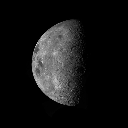
I had fun imagining this part of the Moon facing Earth - I wonder if the Moscoviense basin rings would be large enough for a person standing on Earth to see with the naked eye!
Some processing notes: I mostly used the frames from the A camera, which were a little sharper than those of the B camera. Unfortunately, there was a large gap in coverage on the limb from the A camera images, which forced me to resort to using a B camera image (and wouldn't you know it, it's the most blurred of the bunch!). Photoshop's motion blur removal tool seemed sufficient to fix the worst of it, and I've also applied a slight sharpening filter to the finished mosaic and a half pixel gaussian filter to reduce a bit of marbling that the sharpening created.
Very nice! And I think you may be right about those big basin rings being visible from Earth without a telescope, if they faced us. It looks feasible.
Phil
Phil
Jason Davis of the Planetary Society told me there should be an update on the Surveyor Digitization Project in a week or two. Looking forward to that!
I can say that the results I have seen are stunning. One ongoing problem is the lack of proper metadata. I hope raw data can be released without (or prior to the preparation of) PDS-standard metadata.
Remember LOIRP? The recovery of Lunar Orbiter digital data from original tapes. It was largely successful, but the results are still only partially accessible, unless I am missing something.
Phil
Remember LOIRP? The recovery of Lunar Orbiter digital data from original tapes. It was largely successful, but the results are still only partially accessible, unless I am missing something.
Phil
I spent a few enjoyable days in Flagstaff last month, poking around in the archives with the help of David Portree. Here is something I found which has never been seen since the committees involved considered it. Part of this story is told in Don Wlihelms' To a Rocky Moon and my International Atlas of Lunar Exploration, but the full story revealed here has not been published anywhere.
In June 1969 it was still not certain that Apollo 11 would land successfully, or which site it would land at (it was targeted for Apollo Site 2 in Mare Tranquillitatis, but a launch delay could have moved it to Site 3 in Sinus Medii or Site 5 in Oceanus Procellarum). Nevertheless, Apollo planners were thinking ahead to the second landing, and its goal was a pinpoint landing (within walking distance of a specific target point). Therefore, a list of suitable target points was needed. Before the Apollo Site Selection Board settled on Surveyor 3 as the pinpoint target, small fresh craters in the pre-defined landing ellipses were favoured. Newell Trask of USGS Menlo Park was given the job of selecting the points.
On 19 June 1969 he responded with a memo to James Sasser of the NASA Manned Spacecraft Center (now JSC). He provided coordinates for 8 points in Site 2, 8 points in Site 3 and 9 points in Site 5. But they were not latitude and longitude, they were measurements in centimeters on individual framelets of specific Lunar Orbiter images. I have now mapped those points and have posted the map here. One point at Site 5 did become the backup landing target for Apollo 12. At Site 2 the map also shows the locations of two areas which were modelled at Cinder Lake, near Flagstaff, by setting off explosives to create craters. Google Earth shows those craters still, with the Flagstaff landfill between them.
The Wilhelms version of this story only refers to Site 5 and does not specify the locations. My earlier book included a map for Site 5 based on a list from another memo by Farouk El Baz, taken from Trask's memo, but I had never seen the full list until last month.
Phil
Click to view attachment
Another goody I had not seen before. Planned EVAs at Tsiolkovsky crater on the far side, from the plan for the final Apollo landing promoted by Jack Schmitt. This is from a study of the communication relay satellite that would be needed for that mission.
Phil
Click to view attachment
Phil
Click to view attachment
Wow - I had no idea about that Tsiolkovsky mission! That's a very interesting area for all sorts of geological reasons (apart from being visually spectacular). What a shame that never happened.
P
P
While we wait for a new crop of lunar landers, and in honor of John Young, here is an image from Apollo 16. This is the panorama taken at Station 4 on Stone Mountain, the southernmost point of the traverse, in circular form. It gives a great view out to the north across the landing site.
I just recently completed the remapping of Apollo 16 EVA routes using LROC images.
Phil
Click to view attachment
I just recently completed the remapping of Apollo 16 EVA routes using LROC images.
Phil
Click to view attachment
and new images from DSLWP-B
http://lilacsat.hit.edu.cn/dashboard/pages_en/pics-b.html
color corrected farside images
https://twitter.com/cgbassa/status/1051493157056249856
http://lilacsat.hit.edu.cn/dashboard/pages_en/pics-b.html
color corrected farside images
https://twitter.com/cgbassa/status/1051493157056249856
Here is another Apollo 16 view - North Ray crater, one of the polarization panoramas.
Phil
Click to view attachment
Phil
Click to view attachment
Has anyone seen the complete catalogue of images from the Surveyor Digitization Project? Jason Davis of the Planetary Society posted a few images back in 2016, but that's the best I could find. I would have assumed Phil would have had a field day with all the raw images after all the hard work he did when he cleaned up the older mosaics. I can't even find a home website for the project.
Not released yet. I am not up to date with progress, but my understanding is that they have the pictures but they are trying to put together the metadata - all the information about the time, pointing, exposure time and so on. They need it all to submit it all to the Planetary Data System.
Phil
Phil
While Yutu 2 is snoozing I can catch up on some other goodies. Here is an Apollo panorama which I have never seen assembled before (yes, there is plenty that an enterprizing image processor can still do with Apollo). This is the Apollo 16 'rover pan' taken in EVA 3 on the rim of Palmetto crater. Charlie Duke took pictures as John Young drove the rover in a tight circle. Duke took pictures for half a panorama, not the whole 360 degrees, looking into Palmetto. The original images are low contrast, and here I have greatly enhanced contrast to show the crater interior.
Phil
Click to view attachment
Phil
Click to view attachment
And another taken a few minutes later as they passed a rimless depression Duke called a 'doodlebug hole'.
Phil
Phil
Superb, mention, history and recording such, Phil...of times, perhaps, lost if unknown.
Currently reading 'First Man' by Hansen, J. R. - this Amazon link https://www.amazon.co.uk/First-Man-Life-Nei...g/dp/1476727813 - (intentionally ignored the film): a wonderful history here, too, of Armstrong's life, his experiences, flights and fights, before.... Some wonderful historic, nostalgic images, too.
Mention, may not fall within the UMSF criteria/rules...I know, so apologies (but with appreciation) to the Admin if they allow, the above resource does also involve UMSF references (minimally, let's say)
I am working on a new map of lunar impact and landing sites. This is a preview, and the final map will include a sidebar with a list of all landings and impacts with date and coordinates.
Phil
Click to view attachment
Phil
Click to view attachment
That's totally awesome, Phil. Thanks for sharing.
This is the current version of the lunar sites map. The empty space is for future events. I am not copyrighting this. Do what you want with it.
Phil
Click to view attachment
Phil
Click to view attachment
QUOTE (Phil Stooke @ May 4 2019, 07:12 AM) 
This is the current version of the lunar sites map. The empty space is for future events. I am not copyrighting this. Do what you want with it.
Phil
Click to view attachment
Phil
Click to view attachment
For the unknown location of the Apollo 16 LM Ascent stage, is there not seismic data of the impact that can give its location? There were four active seismometers back then, was there not?
for Phil (or anyone else interested)
Apollo 15 (and possibly Apollo 16) used their 16mm Mauer movie camera mounted on the lunar rover to film part of their surroundings while traveling between stations. Since the camera was in a fixed position, wouldn't it be possible to stitch frames together to show super-long linear photographic strips of terrain? It's just an odd thought I had.
I hope this doesn't violate rules. I'm only discussing photography, nothing else.
Steve - we don't know when the impact happened either, so it is not easy to separate out that impact from any other natural event. If it occurred on the opposite side of the Moon it would be a weak signal as well, maybe too weak. As far as I know, nobody has claimed to have seen that specific signal.
Monitor, it's not a bad thought. Apollo 15's 16 mm camera only worked very briefly. I did actually use its images to locate tracks on the west rim of Dune crater, the only place where it is useful. This is a link to my LPSC poster on the topic:
https://www.hou.usra.edu/meetings/lpsc2018/eposter/1007.pdf
Because the Apollo 15 16mm camera didn't work well it was supplemented on Apollo 16 by images taken by Charlie Duke at frequent intervals. But then the 16mm camera worked well for them. I found the astronaut photos more useful than the 16mm images. Now I'm using the pictures taken by Jack Schmitt on Apollo 17 to map those traverses. More about that soon.
Phil
QUOTE (monitorlizard @ May 5 2019, 10:27 PM)
for Phil (or anyone else interested)
Apollo 15 (and possibly Apollo 16) used their 16mm Mauer movie camera mounted on the lunar rover to film part of their surroundings while traveling between stations. Since the camera was in a fixed position, wouldn't it be possible to stitch frames together to show super-long linear photographic strips of terrain? It's just an odd thought I had.
I hope this doesn't violate rules. I'm only discussing photography, nothing else.
Apollo 15 (and possibly Apollo 16) used their 16mm Mauer movie camera mounted on the lunar rover to film part of their surroundings while traveling between stations. Since the camera was in a fixed position, wouldn't it be possible to stitch frames together to show super-long linear photographic strips of terrain? It's just an odd thought I had.
I hope this doesn't violate rules. I'm only discussing photography, nothing else.
The DAC 16mm cameras were mostly facing forward during the drives. I think there's potential on EVA 3 near North Ray. There's more potential for orbital shots that can be stitched, even editing out the window frame in some shots. I can't find any good HD quality downloads anywhere. The available locations have blurred (out of focus) edges which means they were transferred poorly via telecine style and not scanned using modern transfer equipment. Spacecraft Films is offering all the onboards for $450 USD but that's a big gamble and they're not very active anymore.
NASA has good quality HD scans available on Archive.org.Here's some from Apollo 15: https://archive.org/details/Apollo-15_Onboa...ilm-Mags_EE.mxf
There are some frame-rate conversion and black clipping issues on some videos, but it's a great source.Incredible potential for image processing here.
There are some frame-rate conversion and black clipping issues on some videos, but it's a great source.Incredible potential for image processing here.
Thanks for that link, 4throck, I really enjoyed watching that footage, though I see it's not really useful for stitching. I suppose a really determined image processor could do a geometric transformation of each frame but it wouldn't be worth the headache. SteveG, I agree about the orbital 16mm movie footage being more promising. I've seen Apollo orbital footprint maps that show long contiguous sequences of 16mm filming, apparently at nadir, that could be stitched into long, thin mosaics. I'm not an image processor, but I'd certainly be interested in seeing what would result if somebody did this. The only thing is, viewing it on a computer screen would look the same as watching the footage!
QUOTE (Phil Stooke @ May 4 2019, 05:12 PM)
This is the current version of the lunar sites map.
It looks like you will have to update the map very soon: DSLWP-B to crash on or around next July 31
Yes, and Chandrayaan 2 in about September, and Chang'e 5 in December.
Phil
Phil
QUOTE (monitorlizard @ May 7 2019, 09:03 AM)
<br />Thanks for that link, 4throck, I really enjoyed watching that footage...
There are some interesting things on NASA's resource reels, and also on some vintage documentaries.
Looking elsewhere, and to stay on topic, searching Youtube for "Surveyor 3" gets you:
https://www.youtube.com/watch?v=E6yQfbFMBcY
https://www.youtube.com/watch?v=3WFT5_jLLjU
Both are very interesting
There's much more about other missions if you know where to look, including some Pioneer video images, but that's better discussed on a specific topic about image sources I think.
Here is the latest version of the Lunar Sites map. I have added Chandrayaan 2 (Vikram) and Longjiang 2 impacts, and moved Chandrayaan 1's MIP impact to the far side as I now believe it should be. Next year will see the Chang'e 5 sample return, I hope, and several events can be expected in 2021 - CLPS landings or attempts by Astrobotic and Intuitive Machines, OMOTENASHI (micro-lander from Japan launched with Artemis 1) and perhaps others including mission-ending impacts for Lunar Flashlight and LunarH-Map (also with Artemis 1).
Phil
Click to view attachment
Phil
Click to view attachment
Concerning the Surveyor Digitization Project, I have been in contact with Shane Byrne, who is leading the project to digitize all of the Surveyor lunar images. They are still trying to tie off some loose ends with the dataset. The school semester just ended so they will be starting work on this again soon and should have an update later this summer. Looking forward to this image release!
Thanks, Steve, that is good to know. I have not been keeping up with progress but when I talked to the people involved they were talking about the image metadata as a complicated problem. Each frame they scanned off the film included both an image and a table of metadata so they had to use OCR to extract it and then get it all organized. That process sounds like it's coming to an end. They sent me a few examples of processed images including a bit of a panorama and some color processing. There will be some very cool things to do with these images, and for landing sites that are not well known visually. Old-timers may remember the arduous task of building panoramas from very sub-standard materials which I attempted on UMSF many years ago. That could be vastly superseded soon!
Phil
Phil
So as I mentioned in the Lucy thread, we just made a movie of Sunday night's (US time) total lunar eclipse from the Lucy spacecraft. Lucy is currently near its furthest point from Earth, about 100 million km away, beginning its loop back for its Earth gravity assist next October.
We *think* this is the first movie of a lunar eclipse made from deep space, but does anyone know of other examples?
John
We *think* this is the first movie of a lunar eclipse made from deep space, but does anyone know of other examples?
John
Hmm, I suppose DSCOVR's "view" of an lunar eclipse in 2015 doesn't really count for your purposes? I expect Lucy's view will be more impressive (at least as far as the eclipse is concerned?)
Thanks, though DSCOVR doesnt quite count as deep space in my book. However weve now learned that Messenger did a lunar eclipse movie in 2014 (https://www.planetary.org/space-images/messenger-views-lunar-eclipse), so were not the first from deep space anyway. Still, we think ours is cooler- well be releasing it fairly soon.
John
John
QUOTE (Phil Stooke @ Oct 14 2014, 10:11 AM)
I have just been advised that a project to scan all 85000 or so Surveyor images (from photo negatives) has been funded, and the entire dataset will be available on the web eventually. Not sure of the timeline
Is there any update to this effort to digitize the Surveyor imagery?
QUOTE (Hungry4info @ Aug 13 2023, 06:49 PM)
Is there any update to this effort to digitize the Surveyor imagery?
Based on https://sic.lpl.arizona.edu/collection/surveyor-digitization all of the images were scanned, but then the project seems to have stalled out before any PDS-compliant datasets were built. Last update was in 2018?
PDS wants both the image files and the metadata. The people involved probably ran out of time or money before all the metadata could be extracted from the scanned images (there is some detail on this among the links on that page). Ideally the raw scans could be made available without the metadata. I will see if I can find out more.
Phil
Phil
I have been in touch with the people involved. Money ran out for the metadata part of the job so it has limped along with pro-bono work, but speeded up recently with a student worker. They are close to having it ready for the three later missions and trying to get the first two sorted out.
No timeline yet but good to know progress is being made.
Phil
No timeline yet but good to know progress is being made.
Phil
Thank you so much! It's great to hear that I've been looking forward to this ever since I learned of the project.
I've been looking forward to this ever since I learned of the project.
I am posting a set of maps to show the gradual unveiling of the Moon's far side. from what was known before the space age (not quite nothing) up to Clementine, step by step for each mission. They cam be found at:
https://mastodon.social/@PhilStooke
Some of them have been posted here in the past.
Phil
https://mastodon.social/@PhilStooke
Some of them have been posted here in the past.
Phil
I am just starting a set of maps of every lunar landing site on:
https://mastodon.social/@PhilStooke
Many of these will have appeared on UMSF in the past but this will collect them in one place. Typically there will be one close-up map and one context map. The set will run in chronological order so Luna 9 will be the first. I'll post the first one here but the rest will be on Mastodon.
Phil
Click to view attachment
It looks like the Surveyor Digitizing has been completed?
https://sic.lpl.arizona.edu/surveyor-digitization
Lots of new images here. Many I hadn't seen before. I'm going through them in mission order and I'll attach a few from Surveyor 1. I'm not yet sure if these images exist in a raw form, but I've screenshot them from the scan of the printouts. A couple are of the horizon. One is of the radiator* panel which seems to have been damaged some time in the night.
(*corrected)
You didn't get any replies to this but I did spend some time looking at it. Yes, lots of useful things here.
Phil
Phil
This is a "lo-fi" version of our main content. To view the full version with more information, formatting and images, please click here.