Whole Earth images, Does any satellite provide regularly updated ones? |

  |
Whole Earth images, Does any satellite provide regularly updated ones? |
 Aug 13 2011, 03:43 PM Aug 13 2011, 03:43 PM
Post
#166
|
|
 Martian Photographer  Group: Members Posts: 353 Joined: 3-March 05 Member No.: 183 |
I don't know the instrument--but that sort of thing is frequently due to a double reflection within a window that separates the fore-optics from the outside universe. Depending on the material (silica, sapphire, ...) you get a significant fall-off for a double reflection, and then the same fall-off to quad, etc.
|
 |
 
|
|
Aug 13 2011, 06:56 PM
Post
#167
|
|
 Senior Member Group: Members Posts: 2173 Joined: 28-December 04 From: Florida, USA Member No.: 132 |
QUOTE (elakdawalla @ Aug 13 2011, 09:43 AM)  ...There is a ghost image of Earth about three diameters to the right of the actual image... There is also a ghost image the same distance to the left. |
|
|
|
|
Aug 14 2011, 12:00 AM
Post
#168
|
|
 Senior Member Group: Members Posts: 1670 Joined: 5-March 05 From: Boulder, CO Member No.: 184 |
QUOTE (Juramike @ Apr 22 2011, 12:25 AM) Good catch! It is indeed the Neogene-Miocene period as the last step in the animated gif. The work that Stu originally referred to was done in collaboration by Dr. Ron Blakely of Northern Arizona University. (The animations in the wikipedia entry were done by Dr. Ron Blakely.) Here is his website that has individual maps of each of the paleo-reconstructions (including Pleistocene and Present) : http://jan.ucc.nau.edu/~rcb7/mollglobe.html And a website to other detailed data products: http://cpgeosystems.com/index.html I recently got a copy of his (beautifully illustrated) book: "Ancient Landscapes of the Colorado Plateau", mentioned on his site. I highly recommend it. Yes, this is a good dataset. We've used a smoother version of this animation in Science On A Sphere. http://sos.noaa.gov/datasets/Land/paleo.html A frame exists for the future projection of the continents. I've considering making an augmented version of the animation that incorporates this into the future. Steve -------------------- Steve [ my home page and planetary maps page ]
|
|
|
|
| Guest_Oersted_* |
Aug 14 2011, 01:33 PM
Post
#169
|
|
Guests |
QUOTE (ugordan @ Sep 16 2010, 11:39 PM) Here's a colorization of this LRO Earth image. Below is a preview at 10% resolution, 1/2 res version is available here (2.3 MB) and full res version here (8 MB). [attachment=22521:lroc_ear...00809_th.jpg] Very lovely, except for the Photoshop masking artifacts around the edge (mainly in the 12 o'clock to 2 o'clock positions). |
|
|
|
|
Dec 23 2011, 01:50 AM
Post
#170
|
|
 Senior Member Group: Moderator Posts: 2785 Joined: 10-November 06 From: Pasadena, CA Member No.: 1345 |
The NPP mission is making a Global Image (not just hemispherical) of the Earth every day. Here is the first image release:
http://earthobservatory.nasa.gov/IOTD/view.php?id=76674 "It's 1:30 PM somewhere..." -------------------- Some higher resolution images available at my photostream: http://www.flickr.com/photos/31678681@N07/
|
|
|
|
|
Jan 28 2012, 11:10 AM
Post
#171
|
|
 Senior Member Group: Members Posts: 3650 Joined: 1-October 05 From: Croatia Member No.: 523 |
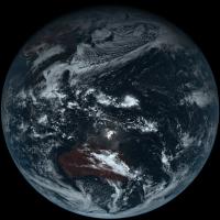
Rosetta Earth flyby 2 revisited, magnified 1.5x from original scale and rotated so north is up:
 This one was hard to work with. The red and especially the green channel suffers from a ghost image which makes the composite look ugly. I tried subtracting them out as best as I could but it still left residual images of the bright clouds in the green channel. As a result, fair portions of the sea and cloud areas use synthetic green while most of the land masses use RGB colorm as synthetic green doesn't produce satisfactory color. -------------------- |
|
|
|
|
Jan 28 2012, 09:21 PM
Post
#172
|
|
 Senior Member Group: Members Posts: 2492 Joined: 15-January 05 From: center Italy Member No.: 150 |
Great work, Gordan!
-------------------- I always think before posting! - Marco -
|
|
|
|
|
Jan 28 2012, 09:22 PM
Post
#173
|
|
|
Founder Group: Chairman Posts: 14444 Joined: 8-February 04 Member No.: 1 |
I abandoned the very same data set for the reasons you mention.... GREAT work.
|
|
|
|
|
Jan 12 2014, 08:34 PM
Post
#174
|
|
|
Senior Member Group: Members Posts: 1670 Joined: 5-March 05 From: Boulder, CO Member No.: 184 |
QUOTE (scalbers @ Aug 14 2011, 01:00 AM) Yes, this is a good dataset. We've used a smoother version of this animation in Science On A Sphere. http://sos.noaa.gov/datasets/Land/paleo.html A frame exists for the future projection of the continents. I've considering making an augmented version of the animation that incorporates this into the future. Steve Updating this post - the animation for past continental drift has moved to here: http://sos.noaa.gov/Datasets/dataset.php?id=336 And I've been putting together a future projection animation, from some of Ron Blakey's future frames: http://sos.noaa.gov/Datasets/dataset.php?id=424 -------------------- Steve [ my home page and planetary maps page ]
|
|
|
|
|
Mar 12 2015, 11:04 PM
Post
#175
|
||
|
Senior Member Group: Members Posts: 1670 Joined: 5-March 05 From: Boulder, CO Member No.: 184 |
Here is a sample image from the Himawari AHI color imager. Full color and very high resolution. The available one is 11000x11000 pixels (about 1km resolution). This is a sample of a newly launched weather satellite. Will be interesting to see how high of a resolution is publicly available in real-time.
http://www.jma-net.go.jp/sat/data/web89/pa.../trc/trc_LL.jpg http://www.jma.go.jp/jma/jma-eng/satellite...rst_images.html -------------------- Steve [ my home page and planetary maps page ]
|
|
|
|
|
|
|
Oct 15 2015, 07:35 PM
Post
#176
|
|
|
Senior Member Group: Members Posts: 1670 Joined: 5-March 05 From: Boulder, CO Member No.: 184 |
QUOTE (Juramike @ Dec 23 2011, 01:50 AM) The NPP mission is making a Global Image (not just hemispherical) of the Earth every day. Here is the first image release: http://earthobservatory.nasa.gov/IOTD/view.php?id=76674 "It's 1:30 PM somewhere..." VIIRS composites are also available here: http://www.nnvl.noaa.gov/site-custom/true.php -------------------- Steve [ my home page and planetary maps page ]
|
|
|
|
|
Apr 29 2017, 08:52 PM
Post
#177
|
|
|
Senior Member Group: Members Posts: 1670 Joined: 5-March 05 From: Boulder, CO Member No.: 184 |
GOES-16 has been up a while. I'm unsure if real-time data are available yet. It's one thing to get images online, though the ABI has 16 channels and judicious use of the "data" can allow construction of more visually realistic imagery. The full disk data is 0.5 to 2km resolution (depending on wavelength) every 15 minutes.
The main idea is that red is at 500m resolution, blue is at 1km, and near-IR data at 2km can be used to help synthesize the green vegetation. Most of the "True-Color" online images are actually somewhat enhanced, though access to the data can help to make more of a natural color image. The thing I would look for is the ABI L1b radiance products. Maybe CLASS will be made public in the near future? -------------------- Steve [ my home page and planetary maps page ]
|
|
|
|
|
Feb 25 2018, 12:19 PM
Post
#178
|
||
 Member Group: Members Posts: 569 Joined: 20-April 05 From: Silesia Member No.: 299 |
LOIRP data are available in PDS.
Lunar Orbiter 5 - Frame_5027_H3
-------------------- Free software for planetary science (including Cassini Image Viewer).
http://members.tripod.com/petermasek/marinerall.html |
|
|
|
|
|
|
Feb 26 2018, 10:29 PM
Post
#179
|
|
 Administrator Group: Admin Posts: 5172 Joined: 4-August 05 From: Pasadena, CA, USA, Earth Member No.: 454 |
Here's a link: https://pds-imaging.jpl.nasa.gov/volumes/loirp.html
-------------------- My website - My Patreon - @elakdawalla on Twitter - Please support unmannedspaceflight.com by donating here.
|
|
|
|
|
Jan 16 2022, 06:55 PM
Post
#180
|
|
|
Senior Member Group: Members Posts: 1670 Joined: 5-March 05 From: Boulder, CO Member No.: 184 |
Here are latest full disk images from GOES-West:
https://www.star.nesdis.noaa.gov/goes/fulld...R&length=12 Note that the Level 1b data are available for both GOES and Himawari on AWS. -------------------- Steve [ my home page and planetary maps page ]
|
|
|
|
|

|
Lo-Fi Version | Time is now: 19th October 2024 - 03:45 PM |
|
RULES AND GUIDELINES Please read the Forum Rules and Guidelines before posting. IMAGE COPYRIGHT |
OPINIONS AND MODERATION Opinions expressed on UnmannedSpaceflight.com are those of the individual posters and do not necessarily reflect the opinions of UnmannedSpaceflight.com or The Planetary Society. The all-volunteer UnmannedSpaceflight.com moderation team is wholly independent of The Planetary Society. The Planetary Society has no influence over decisions made by the UnmannedSpaceflight.com moderators. |
SUPPORT THE FORUM Unmannedspaceflight.com is funded by the Planetary Society. Please consider supporting our work and many other projects by donating to the Society or becoming a member. |
|