Geomorphology of Cape York and Solander Point, Examining Opportunity's destination at Endeavour Crater |

  |
Geomorphology of Cape York and Solander Point, Examining Opportunity's destination at Endeavour Crater |
 Jul 8 2010, 03:19 PM Jul 8 2010, 03:19 PM
Post
#16
|
|
 Member  Group: Members Posts: 656 Joined: 20-April 05 From: League City, Texas Member No.: 285 |
A waterfall .... now, that's a neat idea. I'd envisioned a little rivulet gradually eroding the Wedge, but I rather like the waterfall idea.
A good stereo pair would be really helpful. That, or activate Oppy's heretofore unused (and undiscussed) JATO rockets to get there faster 
|
 |
 
|
|
Jul 8 2010, 03:28 PM
Post
#17
|
|
|
Member Group: Members Posts: 890 Joined: 18-November 08 Member No.: 4489 |
waterfall , i guess it is time to start to rethink my very old "blue mars" map so the next time some one wants to put it on a discovery chan show it will be " more" correct.
|
|
|
|
|
Jul 8 2010, 03:33 PM
Post
#18
|
||
|
Member Group: Members Posts: 656 Joined: 20-April 05 From: League City, Texas Member No.: 285 |
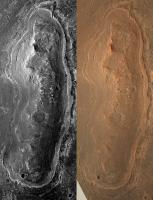
Well, I said a "good" stereo pair would be helpful. Here's a cross-eyed pair, using the last couple of images posted. These may be from the same image, for all I know, but I'm pretty sure I'm getting a stereo effect, particularly around the Wedge. Overall quality is not great, but it's something different.
|
|
|
|
|
|
|
Jul 8 2010, 03:39 PM
Post
#19
|
|
|
Solar System Cartographer Group: Members Posts: 10197 Joined: 5-April 05 From: Canada Member No.: 227 |
I guess my reason for preferring a non-shoreline model is that I'm doubtful that an open body of water could have existed for long enough to create typical shoreline features like beaches, or that it would have been covered with ice, or that unconsolidated deposits like beaches could remain recognizable after all this time. Erosion might be slow on Mars but it can still have an effect on loose material. But I'll agree that other explanations than mine are possible, so let's see what we find. It might be interesting to consider what landforms or deposits you would expect the rover to see if this is a beach rather than superimposed layered sediment.
(PS this isn't distant vistas any more...) Phil -------------------- ... because the Solar System ain't gonna map itself.
Also to be found posting similar content on https://mastodon.social/@PhilStooke Maps for download (free PD: https://upload.wikimedia.org/wikipedia/comm...Cartography.pdf NOTE: everything created by me which I post on UMSF is considered to be in the public domain (NOT CC, public domain) |
|
|
|
|
Jul 8 2010, 04:04 PM
Post
#20
|
|
|
Senior Member Group: Members Posts: 3002 Joined: 30-October 04 Member No.: 105 |
Phil, my take on this is the deposition of and differential erosion of strata of differing resistances, deposited as essentially flat-lying beds over a pre-existing hill. Use known processes and KISS until you have proof otherwise.
--Bill -------------------- |
|
|
|
|
Jul 8 2010, 04:49 PM
Post
#21
|
|
 The Poet Dude Group: Moderator Posts: 5551 Joined: 15-March 04 From: Kendal, Cumbria, UK Member No.: 60 |
QUOTE (algorimancer @ Jul 8 2010, 04:19 PM)  A good stereo pair would be really helpful. Ask, and ye shall receive... http://roadtoendeavour.files.wordpress.com...-york-in-3d.jpg -------------------- |
|
|
|
|
Jul 8 2010, 04:51 PM
Post
#22
|
|
|
The Poet Dude Group: Moderator Posts: 5551 Joined: 15-March 04 From: Kendal, Cumbria, UK Member No.: 60 |
QUOTE (Phil Stooke @ Jul 8 2010, 04:39 PM) (PS this isn't distant vistas any more...) I think discussing Cape York here is valid, as we're all just waiting to see it appear on the horizon as part of the "distant vista", but if others agree with you then I'd be fine with someone starting a "Cape York" thread. -------------------- |
|
|
|
|
Jul 8 2010, 05:02 PM
Post
#23
|
|
 Senior Member Group: Admin Posts: 4763 Joined: 15-March 05 From: Glendale, AZ Member No.: 197 |
QUOTE (Stu @ Jul 8 2010, 09:51 AM) I'd be fine with someone starting a "Cape York" thread. So let it be written, so let it be done. -------------------- If Occam had heard my theory, things would be very different now.
|
|
|
|
|
Jul 8 2010, 05:26 PM
Post
#24
|
|
|
Member Group: Members Posts: 656 Joined: 20-April 05 From: League City, Texas Member No.: 285 |
Great stereo, Stu (much better than the one I improvised). The more I look at this, the more I think "beach". Consider that, if Endeavour were flooded, with the water extending beyond the current rim (so that Cape York was an island), the big open deep water would be to the east of Cape York, and consequently the major wave action would be from that direction. All along the east side of Cape York is what appears to be a longshore bar, which might be expected from that wave action. This feature is largely lacking to the west. It makes sense that, as the water declined, water which accumulated behind the bar would channelize and flow through gaps. While the Wedge seems most prominent, I also see signs of channels to the south of it (immediately below the apparent small crater in the "bar", and a smaller channel at the northern "point" of Cape York. I see signs of channels feeding into these 3 outlets which are traceable southwards beyond half the length of the Cape.
Here's a portion Wikipedia's description of beach geology: "There are several conspicuous parts to a beach, all of which relate to the processes that form and shape it. The part mostly above water (depending upon tide), and more or less actively influenced by the waves at some point in the tide, is termed the beach berm. The berm is the deposit of material comprising the active shoreline. The berm has a crest (top) and a face the latter being the slope leading down towards the water from the crest. At the very bottom of the face, there may be a trough, and further seaward one or more longshore bars: slightly raised, underwater embankments formed where the waves first start to break. The sand deposit may extend well inland from the berm crest, where there may be evidence of one or more older crests (the storm beach) resulting from very large storm waves and beyond the influence of the normal waves. At some point the influence of the waves (even storm waves) on the material comprising the beach stops, and if the particles are small enough (sand size or smaller) , winds shape the feature. Where wind is the force distributing the grains inland, the deposit behind the beach becomes a dune." |
|
|
|
|
Jul 8 2010, 05:30 PM
Post
#25
|
|
|
The Poet Dude Group: Moderator Posts: 5551 Joined: 15-March 04 From: Kendal, Cumbria, UK Member No.: 60 |
QUOTE (algorimancer @ Jul 8 2010, 06:26 PM) Great stereo, Stu (much better than the one I improvised). Thanks, but can't take credit for that; I just used the IAS Viewer to view the already-existing anaglyph of the area, then stitched together four close crops of it. Thanks to the amazing HiRISE team for the stunning images! -------------------- |
|
|
|
|
Jul 8 2010, 06:34 PM
Post
#26
|
|
|
Senior Member Group: Members Posts: 3516 Joined: 4-November 05 From: North Wales Member No.: 542 |
Back to something I mentioned before but, since at last we have a special thread and more people contributing, here it is once more. It's about the beach/not-beach issue. One sure way to demolish the beach idea is to show that any hypothetical Endeavour lake would have had an outflow at a lower level than this terrace. If on the other hand the outflow point is found to be very close to the level of the terrace this could be seen as a 'fulfilled prediction' of the beach hypothesis. Lakes that drain can have levels that are stable for long periods, whereas lakes that don't tend to fluctuate or steadily decrease in level, militating against significant beach formation like Phil said.
I'm surprised that no-one here has seriously grappled with the relative elevations. I've made my own clumsy attempt and I think the elevations are fairly close - but that's really not good enough. |
|
|
|
|
Jul 8 2010, 07:57 PM
Post
#27
|
|
|
Member Group: Members Posts: 656 Joined: 20-April 05 From: League City, Texas Member No.: 285 |
QUOTE (ngunn @ Jul 8 2010, 12:34 PM) ...I'm surprised that no-one here has seriously grappled with the relative elevations.... It seems like Google Mars with the MOLA elevation database and overlaid high resolution imagery ought to get close to an answer. It's too bad it doesn't have the explicit capability of adding a water layer at a particular elevation, though this might be improvised (I'm afraid I just don't have the time lately, else I'd try it). One issue with applying this to ancient times may be that previously saturated subsurface/sediments may have subsequently lost water to sublimation and consequently altered the topography. |
|
|
|
|
Jul 8 2010, 10:26 PM
Post
#28
|
|
 Senior Member Group: Members Posts: 1619 Joined: 12-February 06 From: Bergerac - FR Member No.: 678 |
Okay……
-------------------- |
|
|
|
|
Jul 8 2010, 11:18 PM
Post
#29
|
|
|
Founder Group: Chairman Posts: 14433 Joined: 8-February 04 Member No.: 1 |
I'm wondering if you could take word-pedantry to another website. Please, just don't have that discussion here, yet again.
|
|
|
|
|
Jul 8 2010, 11:19 PM
Post
#30
|
||
|
Newbie Group: Members Posts: 15 Joined: 28-November 08 From: Germany Member No.: 4498 |
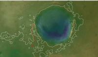
QUOTE I'm surprised that no-one here has seriously grappled with the relative elevations. Here is an attempt using a DTM from HRSC data (H3198_0001_DT4.IMG), blended with the nadir view (H3198_0001_ND4.IMG). The hypothetical shoreline in shown in white. It is more or less equivalent to the -1480 m contour (estimated from Google Mars because I introduced some sort of offset during file convertion). I can´t find a contour that completely surrounds the hill in question, but that may be because of the resolution of the DTM. Still, this contour line implies a maximum depth of about 410 m for the lake, and some lagoons along the east rim (anyone want to look for shorelines?). Also, at this lake level the hypothetical lake would just begin to spill into a large basin to the southeast (along the red arrow; the contour lines begin to connect if the lake level is just a few meters higher). If the lake really spilled in that direction, I would expect to see some channels; but at a quick glance I don´t see any. EDIT: Used the correct data set now and changed attachment accordingly.
Attached thumbnail(s)
|
|
|
|
|
|
|

|
Lo-Fi Version | Time is now: 27th June 2024 - 01:20 AM |
|
RULES AND GUIDELINES Please read the Forum Rules and Guidelines before posting. IMAGE COPYRIGHT |
OPINIONS AND MODERATION Opinions expressed on UnmannedSpaceflight.com are those of the individual posters and do not necessarily reflect the opinions of UnmannedSpaceflight.com or The Planetary Society. The all-volunteer UnmannedSpaceflight.com moderation team is wholly independent of The Planetary Society. The Planetary Society has no influence over decisions made by the UnmannedSpaceflight.com moderators. |
SUPPORT THE FORUM Unmannedspaceflight.com is funded by the Planetary Society. Please consider supporting our work and many other projects by donating to the Society or becoming a member. |
|