Geomorphology of Cape York and Solander Point, Examining Opportunity's destination at Endeavour Crater |

  |
Geomorphology of Cape York and Solander Point, Examining Opportunity's destination at Endeavour Crater |
 Feb 10 2011, 05:28 PM Feb 10 2011, 05:28 PM
Post
#46
|
|
 Senior Member  Group: Members Posts: 4256 Joined: 17-January 05 Member No.: 152 |
This is great - thanks Pete. Have you tested your calculations on a known target, like Santa Maria or Victoria and gotten reasonable numbers?
How easy is it to do more profiles? Is it feasible to do several cutting right across Cape York so we can see if the results are consistent? Anyway, such a short Cape York would certainly explain why we haven't spotted it yet. |
 |
 
|
|
Feb 10 2011, 06:18 PM
Post
#47
|
|
|
Member Group: Members Posts: 808 Joined: 10-October 06 From: Maynard Mass USA Member No.: 1241 |
Pete., your Hirise DEM profile of Cape York is very snazzy! Thank you. I agree that the cape is kind of
short compared to what the overhead shot 'implies' (and the fact the we haven't seen it yet!) -------------------- CLA CLL
|
|
|
|
|
Feb 11 2011, 01:55 AM
Post
#48
|
|
 Member Group: Members Posts: 399 Joined: 28-August 07 From: San Francisco Member No.: 3511 |
So Cape York appears to be quite a bit inside Endeavor's "rim slope", I wonder when it will come into view, as sudden as Santa Maria ?...
-------------------- 'She drove until the wheels fell off...'
|
|
|
|
|
Feb 11 2011, 02:38 PM
Post
#49
|
|||
|
Junior Member Group: Members Posts: 59 Joined: 18-July 07 From: London, UK Member No.: 2873 |
Let's see if we can get anything else out of my DEM around Cape York.
I follow the standard USGS way of making these DEMs, so I'm happy with the method, it's just that the results can vary from place to place. I haven't made one around Victoria because, well, it had already been done, and Santa Maria was just off this stereo pair. But Doug and I had some success with a DEM of the pathfinder landing site (http://www.youtube.com/watch?v=uE_Ih0hgnlw), and I'm churning these out for my science at the moment and they match up well with MOLA, CTX, HRSC data. I guess Cape York is actually a nice test! Profiles are no problem, but they're all pretty similar - the local slope into Endeavour just drowns most of the Cape York signal. That could be correct, or it could just be affecting the way that the DEM came out.
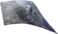
Here's a 3D perspective of Cape York, with a crazy x7 vertical exaggeration.
Looks pretty, but I wouldn't bet the house on it! Pete |
||
|
|
|
||
|
Feb 11 2011, 02:47 PM
Post
#50
|
|||
|
Junior Member Group: Members Posts: 59 Joined: 18-July 07 From: London, UK Member No.: 2873 |
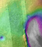
And while I'm filling up the place with images, I had a look at the visibility of Cape York from where Oppy might enter my DEM area.
First up a CTX base DEM with Oppy (green dot) just inside my HiRISE area. It shows up the relative depth of Endeavour compared to the really flat plains.
Then a visibility map (viewshed) of the raw unfiltered (hence noise) 1 m DEM from Oppy at the green dot. Cape York is not visibile as we'd expect.
I tried one the other way around, from the highest point at Cape York and basically you can only really see into the crater. So I guess if I'm right we won't see Cape York until we're right on it, but I'd be happy to be wrong. Pete |
||
|
|
|
||
|
Feb 11 2011, 03:03 PM
Post
#51
|
|
 Senior Member Group: Admin Posts: 4763 Joined: 15-March 05 From: Glendale, AZ Member No.: 197 |
I joked previously that maybe Cape York is nothing more than a stain on the ground. It looks like I wasn't far off.
-------------------- If Occam had heard my theory, things would be very different now.
|
|
|
|
|
Feb 11 2011, 03:23 PM
Post
#52
|
||
|
Senior Member Group: Members Posts: 4256 Joined: 17-January 05 Member No.: 152 |
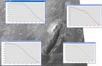
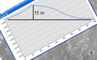
Thanks again, Pete. Those profiles certainly look consistent with each other. Subtracting off the overall slope, the tallest section (blue) gives around 15 metres height, which is starting to sound reasonable:
|
|
|
|
|
|
|
Feb 12 2011, 12:09 PM
Post
#53
|
|
 Senior Member Group: Members Posts: 1089 Joined: 19-February 05 From: Close to Meudon Observatory in France Member No.: 172 |
QUOTE (fredk @ Feb 11 2011, 04:23 PM)  Thanks again, Pete. Those profiles certainly look consistent with each other. Subtracting off the overall slope, the tallest section (blue) gives around 15 metres height, which is starting to sound reasonable: ... Meaning Cape York is well "climbable" by Oppy to get a better view (and to get a nice panorama) from its top : Endeavour's far rim and the other capes should give us a gorgeous view. Like many, I'm drooling over this upcoming view. Yum-Yum ! ... a "Yum-Yum" Pan. Bon Appetit ! (besides, it's lunch time right now in France) 
|
|
|
|
|
Feb 12 2011, 03:53 PM
Post
#54
|
|
|
Member Group: Members Posts: 530 Joined: 21-March 06 From: Canada Member No.: 721 |
Looking at that 3D view, Cape York seems less like a hill to climb, and more like a ledge to drive out onto. I am so looking forward to arrival day. I almost wish I could fast forward to that event. Except that would probably mean winter is just starting again, and I am really, really tired of winter right now.
|
|
|
|
|
Feb 12 2011, 08:43 PM
Post
#55
|
|
|
Senior Member Group: Members Posts: 2922 Joined: 14-February 06 From: Very close to the Pyrénées Mountains (France) Member No.: 682 |
QUOTE (BrianL @ Feb 12 2011, 04:53 PM) Looking at that 3D view, Cape York seems less like a hill to climb, and more like a ledge to drive out onto. I am so looking forward to arrival day. I almost wish I could fast forward to that event. Except that would probably mean winter is just starting again, and I am really, really tired of winter right now. What are you talking about? Arrival time will be by Easter  
-------------------- |
|
|
|
|
Feb 12 2011, 11:05 PM
Post
#56
|
|
|
Senior Member Group: Members Posts: 1057 Joined: 17-February 09 Member No.: 4605 |
QUOTE (fredk @ Feb 11 2011, 03:23 PM) Thanks again, Pete. Those profiles certainly look consistent with each other. Subtracting off the overall slope, the tallest section (blue) gives around 15 metres height, which is starting to sound reasonable: Fred, I'm not sure I follow your logic here. Wouldn't a line of best fit along the plains approach section of the plot give the baseline to estimate the height of Cape York above the plain? I make the maximum height of the blue plot to be around three to four metres? |
|
|
|
|
Feb 13 2011, 03:38 AM
Post
#57
|
|
|
Senior Member Group: Members Posts: 4256 Joined: 17-January 05 Member No.: 152 |
You might be right about that, but I think we'd need to see how the profiles look farther out to know for sure where the plains "start". And as others have said, if that overall slope is right, this isn't a hill, it's more like a ledge to drive out on.
|
|
|
|
|
Feb 13 2011, 07:31 AM
Post
#58
|
|
 The Poet Dude Group: Moderator Posts: 5551 Joined: 15-March 04 From: Kendal, Cumbria, UK Member No.: 60 |
Ok... trying to get my head around this... We're now thinking that Cape York isn't so much a "hill" as a kind of a "ledge" or platform sticking out from the inner slope of Endeavour...? Does that mean the hills that curve around the southern edge of the crater are the same? This is fascinating...
On another note, it was pleasing to find a LOT of interest in the MER mission last night when I gave an Outreach talk out at a little village just outside Kendal. "Mature" crowd, shall we say, general level of interest in science, but still, the ones who were aware that there are rovers on Mars were fascinated by them, and very impressed by what they've achieved. So say we all. -------------------- |
|
|
|
|
Feb 13 2011, 08:15 AM
Post
#59
|
|
|
Senior Member Group: Members Posts: 1057 Joined: 17-February 09 Member No.: 4605 |
The perennial problem with visual representations using axis with the same metric but different scales is the gut reaction 'gee that's steep'. It isn't a particularly steep gradient and rather than a ledge overlooking a chasm it is more of a low ridge with a (roughly) ten degree slope into the crater.
|
|
|
|
|
Feb 13 2011, 08:18 AM
Post
#60
|
|
|
The Poet Dude Group: Moderator Posts: 5551 Joined: 15-March 04 From: Kendal, Cumbria, UK Member No.: 60 |
Gotcha, thanks.
Still... hill... ledge... island... ledge... I need more tea. -------------------- |
|
|
|
|

|
Lo-Fi Version | Time is now: 28th September 2024 - 04:56 AM |
|
RULES AND GUIDELINES Please read the Forum Rules and Guidelines before posting. IMAGE COPYRIGHT |
OPINIONS AND MODERATION Opinions expressed on UnmannedSpaceflight.com are those of the individual posters and do not necessarily reflect the opinions of UnmannedSpaceflight.com or The Planetary Society. The all-volunteer UnmannedSpaceflight.com moderation team is wholly independent of The Planetary Society. The Planetary Society has no influence over decisions made by the UnmannedSpaceflight.com moderators. |
SUPPORT THE FORUM Unmannedspaceflight.com is funded by the Planetary Society. Please consider supporting our work and many other projects by donating to the Society or becoming a member. |
|