The Japanese Hayabusa 2 twitter account reports that the spacecraft has begun descending toward Ryugu in preparation to deploy the MASCOT lander. Nothing on the English twitter as of the time of this post.
https://twitter.com/haya2_jaxa/status/1046965970466746369
Full Version: MASCOT landing on Ryugu
QUOTE (Hungry4info @ Oct 2 2018, 01:07 PM) 
The Japanese Hayabusa 2 twitter account reports that the spacecraft has begun descending toward Ryugu in preparation to deploy the MASCOT lander. Nothing on the English twitter as of the time of this post.
https://twitter.com/haya2_jaxa/status/1046965970466746369
https://twitter.com/haya2_jaxa/status/1046965970466746369
English twitter account of HAYABUSA 2.
https://twitter.com/haya2e_jaxa
And the realtime images are back http://www.hayabusa2.jaxa.jp/en/galleries/onc/nav20181002/
Follow #Hayabusa2 approach to #Ryugu for #MASCOT delivery in realtime!
https://programmi.000webhostapp.com/hayabus.../simulator.html
Altitude logs:
http://win98.altervista.org/hayabusa2/simu...r/hayabusa2.txt
https://programmi.000webhostapp.com/hayabus...r/ONC_A-log.txt
https://programmi.000webhostapp.com/hayabus.../simulator.html
Altitude logs:
http://win98.altervista.org/hayabusa2/simu...r/hayabusa2.txt
https://programmi.000webhostapp.com/hayabus...r/ONC_A-log.txt
QUOTE (mcmcmc @ Oct 2 2018, 12:02 PM)
Follow #Hayabusa2 approach to #Ryugu for #MASCOT delivery in realtime!
https://programmi.000webhostapp.com/hayabus.../simulator.html
Altitude logs:
http://win98.altervista.org/hayabusa2/simu...r/hayabusa2.txt
https://programmi.000webhostapp.com/hayabus...r/ONC_A-log.txt
https://programmi.000webhostapp.com/hayabus.../simulator.html
Altitude logs:
http://win98.altervista.org/hayabusa2/simu...r/hayabusa2.txt
https://programmi.000webhostapp.com/hayabus...r/ONC_A-log.txt
It appears from the simulator that from 1500 meters on, MINERVA rovers will start to be visible as 1 pixel bright objects in ONC-T. But we'll have to wait down to 400 meters to see them in ONC-W.
ONC-T resolution is 10 times ONC-W, so 1 pixel in ONC-W is 10 pixel in ONC-T.
Spaceflight Now providing live coverage of MASCOT's landing here.
The last three frames show a persistent very bright dot on the surface. Possible MINERVA-II1 rover or protective drum?
Sorry, no - the Minerva area is on the other side of Ryugu. The white spot might be added to the images to indicate the descent target point (I'm only guessing) or it could be a naturally reflective object (there are several of them in earlier images). When somebody posted about the sizes of Minerva hardware in pixels, I think they were really only talking about image resolution, not whether the items would be visible, because they are not near the Masot landing area. For one thing, Mascot is targeted south of the equatorial ridge, Minerva was targeted north of it.
Phil
Phil
Identification of some rocks on photos taken by Hayabusa2 on 2018/10/03 at 00h41 and 01h12 UTC with estimated position of Hayabusa2 shadow
Click to view attachment
Click to view attachment
Click to view attachment
Click to view attachment
Separation confirmed per Spaceflight Now!
QUOTE (nprev @ Oct 3 2018, 04:15 AM)
Separation confirmed per Spaceflight Now!
Tweet confirms it.
Identification of rocks on the picture taken at 1h46 UTC with shadow of Hayabusa 2 as a red cross. The shadow is probably shifted out of the map on the right since the map is missing a vertical band of latitude on 340° and 360°.
Click to view attachment
Click to view attachment
My recording of the delivery operations based on JAXA data (altitude in meters):
Full recording of descent:
https://programmi.000webhostapp.com/hayabus...r/ONC_A-log.txt
There are multiple lines for same data, but if you set up a "sparse data" chart in Excel, multiple lines will result is same point be drawn at same coordinate, so you'll just see one point.
Press conference video (no links to press release yet):
https://www.youtube.com/watch?v=O3WNAg5Zfvs
It looks like national broadcasting company NHK created a simulated realtime video based on JAXA data during descent, but it was live, and I can't find the recording now:
http://www.nhk.or.jp/special/space/#/english
CODE
Alt Generated at (GMT) Received At (GMT))
101 2018-10-03 01:47:38 2018-10-03 02:05:47
47 2018-10-03 01:58:18 2018-10-03 02:16:27 - Mimimum altitude for 4 minutes
134 2018-10-03 02:02:02 2018-10-03 02:20:10 - Hayabusa 2 rises again.
101 2018-10-03 01:47:38 2018-10-03 02:05:47
47 2018-10-03 01:58:18 2018-10-03 02:16:27 - Mimimum altitude for 4 minutes
134 2018-10-03 02:02:02 2018-10-03 02:20:10 - Hayabusa 2 rises again.
Full recording of descent:
https://programmi.000webhostapp.com/hayabus...r/ONC_A-log.txt
There are multiple lines for same data, but if you set up a "sparse data" chart in Excel, multiple lines will result is same point be drawn at same coordinate, so you'll just see one point.
Press conference video (no links to press release yet):
https://www.youtube.com/watch?v=O3WNAg5Zfvs
It looks like national broadcasting company NHK created a simulated realtime video based on JAXA data during descent, but it was live, and I can't find the recording now:
http://www.nhk.or.jp/special/space/#/english
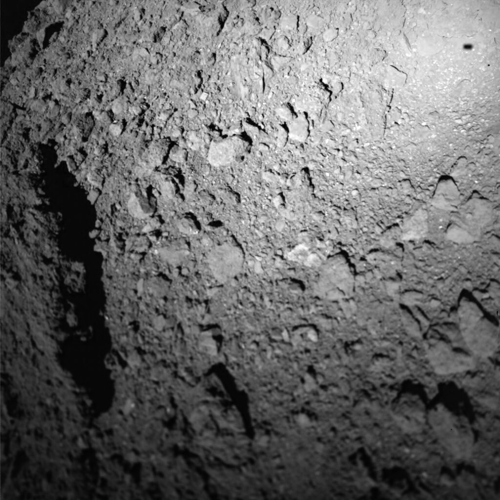
First image of MASCOT released, showing the landing site from an altitude of 40m:
Click to view attachment
Click to view attachment
JAXA just released the picture on its MASCOT lander feed: we even see the shadow of MASCOT 
Click to view attachment
Click to view attachment
QUOTE (neo56 @ Oct 3 2018, 08:48 AM)
JAXA just released the picture on its MASCOT lander feed: we even see the shadow of MASCOT
Click to view attachment
Click to view attachment
Released where? I found this image, but 180° rotated, on MASCOT2018 Twitter feed.
Press conference is continuing on YouTube.
There will be two more updates in 2 resp. 4 hours from now.
There will be two more updates in 2 resp. 4 hours from now.
Mascot is fine after initial issues.
Performing night sequences, all instruments are working.
Performing night sequences, all instruments are working.
"short delay - stay tuned"
https://twitter.com/MASCOT2018/status/1047456139024261121
The team seems very confident in the hopping and uprighting mechanism. The found the first landung spot too dark and unstable, so commanded a first hop at the beginning of the first sol, to begin the science sequence at another location.
Next press conference has a delay but should beginn soon.
The team seems very confident in the hopping and uprighting mechanism. The found the first landung spot too dark and unstable, so commanded a first hop at the beginning of the first sol, to begin the science sequence at another location.
Next press conference has a delay but should beginn soon.
live again...
They had to make an important decision. Therefore the delay.
Spectrometer needs to be in contact with the surface.
Radiometer will tell about thermal conductivity.
Important for deflection of asteroids: What's the arrangement of grains?
Magnetometer: Extremely sensitive, seeing separation, and operation of instruments. Magnetic field data to be cleaned from those instrument operation fields.
They're going to be tired and will drink a beer this evening. Tomorrow, and until Friday, they'll take a look at the data. A first draft of evaluation will take a few more days of computation. But complete evaluaton will take years.
Also interesting: Magentometer team decided to switch off the instrument to safe power, as the have enough data. Let's hope the second sol goes well. The estimate of 16 h battery time probably does not allow for surviving a third night.
I read that expected battery life is just 16 hours and it's not rechargeable (no solar panels), and delivery occurred at around 02:17 GMT.
So MASCOT mission should come to its end at around 18:17 GMT, 3 hours from now.
Indeed. There will be another press conference in 25 min, maybe they tell us more about the expected life time of the battery. I think it is targeted to last at least two sols in the worst case. Also in the grphic from JAXA, end of mission (EOM) is during the third night. Let's hope for the best, and that the DLR team as uploaded a energy saving program for the third night, so MASCOT may have the chance to upload the data in the next morning, if it survives.
Otherwise the last hours in the night without contact are wasted.
The technical reason is the mass constraint. With just 10 kg, solar panels and rechargables are just too heavy. Rechargables and do not have the energy density compared to non-rechargable batteries. Also, the location MASCOT finally settles was unknown, so no sun light guaranteed. And as we have seen with Philae, if the additional power from solar is required for the science goal, this just adds to the risk.
I added a scale to the first picture we have from MASCOT, and Buzz Aldrin to better figure out the scale (like Mystery Man of fredk  )
)
The altitude at which this picture was taken in 25 m and not 40 m as it was previously stated.
Click to view attachment
)The altitude at which this picture was taken in 25 m and not 40 m as it was previously stated.
Click to view attachment
Very nice, those are some big bolders. And again, shadows in the "right" direction makes it so much easier to grasp for my brain.
https://www.youtube.com/watch?v=wSoEapbchGA
JAXA press conference for MASCOT with english translation.
https://www.youtube.com/watch?v=wSoEapbchGA
JAXA press conference for MASCOT with english translation.
QUOTE (neo56 @ Oct 3 2018, 11:18 AM)
I added a scale to the first picture we have from MASCOT, and Buzz Aldrin to better figure out the scale (like Mystery Man of fredk )
)The official unit of all future photographic scale references on Ryugu is now the "Aldrin".

QUOTE (nprev @ Oct 3 2018, 11:52 PM)
The official unit of all future photographic scale references on Ryugu is now the "Aldrin".
Remarkable to consider that some of those human-sized boulders 'weigh' less than a kilo. Aldrin could be chucking them all over the place. (...slowly).
Andy
JAXA announced that live navcam image updates are over for this operation: https://twitter.com/haya2e_jaxa/status/1047724464056782853
Here's all the images assembled into an animation
https://flic.kr/p/PyxrCm
The 3km hover phase at the end gives a nice feel for the rotation
QUOTE
[MASCOT] October 4 at 13:20 JST: The spacecraft is still hovering at an altitude of about 3km, but the real-time broadcast of the navigation images captured by the ONC-W1 has ended. Thank you for watching! http://www.hayabusa2.jaxa.jp/en/galleries/onc/nav20181002/
#AsteroidLanding
Here's all the images assembled into an animation
https://flic.kr/p/PyxrCm
The 3km hover phase at the end gives a nice feel for the rotation
Mission finished. If accomplished... who knows?
https://twitter.com/MASCOT2018/status/1047806424334655488
https://twitter.com/MASCOT2018/status/1047806424334655488
QUOTE (mcmcmc @ Oct 4 2018, 07:38 AM)
Mission finished. If accomplished... who knows?
https://twitter.com/MASCOT2018/status/1047806424334655488
https://twitter.com/MASCOT2018/status/1047806424334655488
The DLR boffins seem much slower in releasing images than their JAXA counterparts and less concerned with public relations generally. (The goofy first-person tweets do not count.) All that data has to have been transmitted from the surface already, since the batteries have died so perhaps waiting on board Hayabusa.
QUOTE (Blue Sky @ Oct 4 2018, 02:58 PM)
The DLR boffins seem much slower in releasing images than their JAXA counterparts and less concerned with public relations generally.
remember Philae, Rosetta's OSIRIS etc. and don't hold your breath for new images.
We have to hope for some embedded scientist to release all the images as someone did for Huygens.
In the press conferences yesterday, it was said, that all data will be downloaded from Hayabusa2 on Friday. Considering, that we got updates nearly every 2 h yesterday from the leading members of the MASCOT team, who were surely occupied otherwise, I think the DLR already did a great job covering the event. Ok, compared to thier performance in this regard on other projects.
Also, JAXA has some nice live coverages, but only with the wide field camera. From all the other instruments, and the MINERVAs, too, the data release is not immediate. We have to remember, which agency does the mission and under what premise. I am not sure about JAXA, but thier main "audience" is Japanese. For Rosetta, ESA was bound by contracts to the very slow release of data that we see now. Maybe not suited for todays culutre, but it was fine at the time the mission was planned. Yes, NASA is very open, but that's how it sees its role in the USA. Concerning the DLR, the culture in Germany is not so much the US view of "tax-payers money, so show the results to the tax-payer", but more state funded research. So the obligation to publicly present the work is far less.
This being said: Where are the images from MASCOT from the surface??
As a comparison - the camera on MASCOT ( MasCam ) is somewhat related to the CIVA cameras on Philae.
4 CIVA images were released to the public after Philae's landing
The full CIVA data was finally released to the ESA PSA in August of this year. That's 13.5 years after the first data was collected by CIVA and 3 years after the end of Philae's mission
Patience is going to be required. Lots of it.
We have been thoroughly spoiled by MER, MSL, Cassini and New Horizons. It is quite apparent that other agencies do not consider that kind of image release policy to be the new normal.
"Inside Information" from a participant of the IAC: There is going to be a press conference at the IAC tomorrow (Friday) at 6:30 UTC, so in about nine hours. But I haven't seen any announcements, tweets so far.
It would be better if everyone would follow rule 2.6. Your comments will be deleted.  Or does rule 2.6 apply only to NASA missions?
Edit: I see, Lex Sternia!
Or does rule 2.6 apply only to NASA missions? Edit: I see, Lex Sternia!
Don't think so, thanks for the reminder.
IAC live stream can be followed here: http://www.iafastro.org/iac-2018-live-streaming/ Unfortunately, it costs 20 .
@Baywa: Are on the show and can tell us what will be presented?
IAC live stream can be followed here: http://www.iafastro.org/iac-2018-live-streaming/ Unfortunately, it costs 20 .
@Baywa: Are on the show and can tell us what will be presented?
@Baywa: Are on the show and can tell us what will be presented?
[/quote]
No, I'm not. But Elizabeth Tasker @girlandkat is tweeting. Have to hurry, breakfast!
[/quote]
No, I'm not. But Elizabeth Tasker @girlandkat is tweeting. Have to hurry, breakfast!
DLR's site now has some images, click the side arrows to see all three images:
https://www.dlr.de/dlr/desktopdefault.aspx/...#/gallery/32253
https://www.dlr.de/dlr/desktopdefault.aspx/...#/gallery/32253
Some previews on twitter by @davide_coco91 https://twitter.com/davide_coco91
Video of MASCOT leaving Hayabusa and picture of surface at hopping location number 2.
Video of MASCOT leaving Hayabusa and picture of surface at hopping location number 2.
Keep an eye on Twitter, hashtag #IAC2018
Here's a surface photo from MASCOT!
Click to view attachment
Cropped and colour-corrected from this tweet: http://twitter.com/davide_coco91/status/1048103752262193152
Here's a surface photo from MASCOT!
Click to view attachment
Cropped and colour-corrected from this tweet: http://twitter.com/davide_coco91/status/1048103752262193152
a new picture from MASCOT - just above the surface of Ryugu
QUOTE (akuo @ Oct 5 2018, 09:53 AM)
DLR's site now has some images, click the side arrows to see all three images:
https://www.dlr.de/dlr/desktopdefault.aspx/...#/gallery/32253
https://www.dlr.de/dlr/desktopdefault.aspx/...#/gallery/32253
These two pictures are from 10 - 20 (25) m above the surface, before the first landing of MASCOT


http://www.hayabusa2.jaxa.jp/en/topics/20181005e_MSC_ONC/
The small asteroid lander, MASCOT, that was developed in Germany and France, was successfully separated from the Hayabusa2 spacecraft on October 3 and delivered safely to the surface of Ryugu. After landing, MASCOT acquired scientific data on the asteroid surface, which was transmitted to the MASCOT team via the spacecraft. Scientific analysis of this data is expected to be performed by the MASCOT team from now onwards.
From the Hayabusa2 spacecraft, we attempted to capture the separated MASCOT using the three optical navigation cameras (ONC-T, ONC-W1, ONC-W2). When the image data was received from the spacecraft, we could confirm that MASCOT appears in images photographed with the ONC-W1 and ONC-W2.
That first image is almost unreal, Yoichi, thanks for finding it for us non-Japanese speakers! Wow!
This is a "lo-fi" version of our main content. To view the full version with more information, formatting and images, please click here.