It's time to open a perijove-4 thread.
Voting is open for another two days. So, don't hesitate too long.
Besides the discussion and the POIs on the mission page, you might consider John Roger's detailed discussion of several interesting features.
If everything goes well, all instruments will be switched on.
Full Version: Juno perijove 4
It'll be good to see JIRAM up and running again! Would love to see what results it'll return on this pass. 
I redecorated the subreddit again, this time in anticipation of Perijove 4! Look decent, do you guys think? Haha
Unofficial status: Be advised that even though PJ4 is at about 5 AM PST tomorrow morning, DSN coverage is spotty, so we may not have the data down until late Friday, if then. I wouldn't expect to see it at missionjuno before Monday at the earliest.
Thanks a lot! This helps planning the processing resources.
Any word on JIRAM or Waves stuff, by any chance?
Note that this pass was in the MWR attitude so the HGA is off earth-point and we can't send science data (engineering only at 250 bps). You can watch https://eyes.nasa.gov/dsn/dsn.html to see if Juno is being tracked and at what data rate. We only went to high rate about 1/2 hour ago, I think, which is one of the reasons why I said we wouldn't have anything soon.
I don't know anything about what the other teams are doing, and if I did, I couldn't say anyway.
I don't know anything about what the other teams are doing, and if I did, I couldn't say anyway.
According to the updated news, all instruments have been operational during PJ4, includung JIRAM:
That's consistent with the plan:
QUOTE
All of Juno's science instruments and the spacecraft's JunoCam were operating during the flyby to collect data that is now being returned to Earth.
That's consistent with the plan:
QUOTE
All of Juno's eight science instruments, including the Jovian Infrared Auroral Mapper (JIRAM) instrument, will be on and collecting data during the flyby.
QUOTE (mcaplinger @ Feb 1 2017, 09:04 PM) 
I wouldn't expect to see it at missionjuno before Monday at the earliest.
Seems I was unduly pessimistic about this, the images went live on missionjuno a few minutes ago.
Note that the image called "Oval BA" is not really of Oval BA. Our targeting process needs some work, as based on my predictions, there was no way we were going to see Oval BA on this pass near the nadir. You can see it in the subsequent image, but it's off on the limb.
They did it again, releasing JunoCam data much earlier than they said they would! Haha! 15 images from Perijove 4 are up on the JunoCam subsite as we speak!
QUOTE (mcaplinger @ Feb 3 2017, 10:56 PM)
... there was no way we were going to see Oval BA on this pass near the nadir. You can see it in the subsequent image, but it's off on the limb.
Click to view attachment
Here a draft version of RGB close-ups. This version did neither use SPICE nor Jupiter's shape, resulting in some rgb misalignment for very close parts of Jupiter.
I've submitted several enhanced crops to missionjuno last night.
The quality of the raw data looks good, lots of interesting features are visible.
I've submitted several enhanced crops to missionjuno last night.
The quality of the raw data looks good, lots of interesting features are visible.
The Pearl of Jupiter

The final image of Jupiter's south pole using Gerald's initial processing with some additional work.
Enhanced Justin's image a little bit.

QUOTE (Roman Tkachenko @ Feb 6 2017, 04:56 PM)
Jupiter's South Pole
Nice
QUOTE (Roman Tkachenko @ Feb 4 2017, 10:07 AM)
The Pearl of Jupiter
Thanks, Roman. It's images like this one that keep me going in the face of all the negative clueless remarks on reddit about the supposed "mediocrity" of Junocam.
This is a 5-fold reduced full version of the PJ04 "Radiation Trend Monitoring" image:
Click to view attachment
This is an enhanced crop of the same image:
Click to view attachment
Mediocre? I wonder, which other camera in a high-radiation environment on a spinning spacecraft would be able to produce images of a similar quality.
Those remarks can only be based on temporary lack of knowledge. I'm sure, by now, they are happy to be proven wrong.
Click to view attachment
This is an enhanced crop of the same image:
Click to view attachment
Mediocre? I wonder, which other camera in a high-radiation environment on a spinning spacecraft would be able to produce images of a similar quality.
Those remarks can only be based on temporary lack of knowledge. I'm sure, by now, they are happy to be proven wrong.
Mike, your 'mediocre' camera is beyond the wildest dreams of achievement of any random hundred thousand anonymous nay-sayers combined, plus their mommies.
We UMSFers value your work tremendously.
We UMSFers value your work tremendously.
The first 20 PJ-04 Departure Movie images.
These drafts are without considering spacecraft motion or Jupiter shape model.
These drafts are without considering spacecraft motion or Jupiter shape model.
QUOTE (nprev @ Feb 9 2017, 12:58 PM)
Mike, your 'mediocre' camera is beyond the wildest dreams of achievement of any random hundred thousand anonymous nay-sayers combined, plus their mommies.
We UMSFers value your work tremendously.
We UMSFers value your work tremendously.
Ditto. Despite the people complaining over at the subreddit, I'm sure they're a vocal minority and the rest of us are also appreciative of the work you guys do.
QUOTE (PhilipTerryGraham @ Feb 14 2017, 07:26 AM)
Despite the people complaining over at the subreddit, I'm sure they're a vocal minority...
My suspicion is that people just look at the basically-raw images on missionjuno and compare them to the best, most heavily-processed press releases from Voyager or Galileo. And they also likely can't tell what the scale of any particular image is -- all Junocam images are limb-to-limb, even the highest-resolution ones, and the maximum resolution is only achieved at the center of the image. If I had the time I would process some high-res Voyager images and compare them to the Junocam images -- in most places Jupiter is pretty bland at the km scale.
QUOTE (mcaplinger @ Feb 15 2017, 04:41 AM)
My suspicion is that people just look at the basically-raw images on missionjuno and compare them to the best, most heavily-processed press releases from Voyager or Galileo.
It's actually they've been mostly comparing JunoCam to Cassini's ISS and New Horizons' LORRI in particular. The people plaguing the comments often complain that JunoCam's pics aren't as "impressive" or "stunning" as images from Cassini or New Horizons. The best I could do was simply say that each camera was built to serve different purposes; I'm not one to start arguments on reddit, especially when I'm supposed to be a neutral moderator.

Say they are lucky to get any images at all, and that a camera was almost not even included! Otherwise Juno would be about as well known to the public as Ulysses was.
QUOTE (Explorer1 @ Feb 14 2017, 12:58 PM)
Say they are lucky to get any images at all, and that a camera was almost not even included!
That sort of argument just feeds into the notion that Junocam is somehow inferior. It's not inferior, it's just different. The driving requirement was to be able to image the full disc of Jupiter from above the pole, which led to a very wide field of view, utterly unlike the instruments that it's being compared to.
An interesting question was brought up by my friend from ANU when he saw the images of Ganymede's shadow - will there ever be a time in the mission where JunoCam will be able to observe a transit shadow up close or, better yet, fly into the shadow of a transit during a perijove? 
I took a look a while back, but that was still when the mission was planning to run 14-day orbits.
Since the moons' orbital planes are inclined to the ecliptic and Jupiter's equatorial plane, Callisto's shadow doesn't currently fall on the planet and won't do so again until sometime around 2020. The track of Ganymede's shadow is also edging north and will continue producing shorter eclipses until about the middle of next year when the eclipse tracks start drifting south again. There should be a series of Ganymede eclipses occurring near the north pole around then.
Europa's eclipse track is currently located along the North Temperate Belt, while Io's is located along the northern edge of the North Equatorial Belt. Like Ganymede's eclipse track, they're also drifting north at the moment, but being closer to the planet, the track positions won't change as substantially.
Right now I'd say Ganymede and Europa have the best chance for close eclipse photos, given the smaller field of view at lower latitudes and the lower likelihood of Io's shadow catching JunoCam's eye during a perijove pass. There's a very tiny chance that the shadows of Amalthea would be visible during a JunoCam pass. I'd need an updated list of perijove encounter times, but it should be trivial to determine if Juno could see eclipses up close.
PJ05 is 2017 MAR 27 08:52:14 (according to SPICE spk file juno_pred_orbit.orb). The later perijoves haven't yet been determined, when I checked for it about two weeks ago.
QUOTE (Gerald @ Feb 19 2017, 02:05 PM)
The later perijoves haven't yet been determined...
http://www.unmannedspaceflight.com/index.p...st&p=233216 shows a list (dates only) through PJ9. I have a later list, of course, but am not authorized to share it.
Adding 53.5 days to last known perijove is difficult, but not beyond the math skills of some on this forum.
Edit: Sorry for the Snark--I thought the question was about the day not the second...
Edit: Sorry for the Snark--I thought the question was about the day not the second...
QUOTE (Floyd @ Feb 19 2017, 05:53 PM)
Adding 53.5 days to last known perijove is difficult, but not beyond the math skills of some on this forum.
The orbit period is not precisely a constant because there are trim maneuvers, especially later in the mission to avoid eclipses. If you only want to know it to a few hours' accuracy, adding a constant may be good enough.
PJ03 Image #73 has been taken 6h42m before PJ04, if I calculated correctly. This may provide some idea about the effect of a few hours.
For predicting any potential Juno transits through a moon's shadow, much more accurate data are required, of course.
For predicting any potential Juno transits through a moon's shadow, much more accurate data are required, of course.
QUOTE (mcaplinger @ Feb 8 2017, 11:45 PM)
Thanks, Roman. It's images like this one that keep me going in the face of all the negative clueless remarks on reddit about the supposed "mediocrity" of Junocam.
Thank you, Mike!
Btw I've made a new, not so overprocessed version of this image.
Here's a high-resolution version

Here's what Eyes on the Solar System has in its current simulation of the Juno mission, with all dates in UTC:
PJ5 - March 27, 2017
PJ6 - May 19, 2017
PJ7 - July 11, 2017
PJ8 - September 1, 2017
PJ9 - October 24, 2017
PJ10 - December 16, 2017
PJ11 - February 7, 2018
PJ12 - April 1, 2018
PJ13 - May 24, 2018
PJ14 - July 16, 2018
PJ15 - September 7, 2018
PJ16 - October 29, 2018
PJ17 - December 21, 2018
PJ18 - February 12, 2019
PJ19 - April 6, 2019
PJ20 - May 29, 2019
PJ21 - July 21, 2019
Deorbit - September 11, 2019
The most accurate published times for perijoves 6 to 8 I'm aware of are
PJ06 2017 May 19, 17:44:04 UTC
PJ07 2017 July 11, 1:55:56 UTC
PJ08 2017 September 1, 21:50:01 UTC
But I think, that the times will be off by up to several minutes, since for PJ05, there is already a discrepancy of 66 seconds to the current prediction in SPICE.
The data are of 2016 December 28 from the latest update of the professional Earth based observation plan.
(This site is easier to read, at least in my browser, but might become obsolete with the next update.)
The most accurate source of PJ times I know of are in the .orb files on the NAIF website. The most recent one is https://naif.jpl.nasa.gov/pub/naif/JUNO/ker...0912_161027.orb but only goes through orbit 22.
QUOTE (mcaplinger @ Feb 22 2017, 05:43 AM)
The most accurate source of PJ times I know of are in the .orb files on the NAIF website. The most recent one is https://naif.jpl.nasa.gov/pub/naif/JUNO/ker...0912_161027.orb but only goes through orbit 22.
I'm thinking that this is the one that Eyes is using. Exact dates and times as to what's simulated.
For the simulation you require more than just the apo- and perijoves. The same NAIF/SPICE directory contains also the file spk_ref_160829_190912_161027.bsp with more detailed information. Together with other kernel files you can simulate most of Juno's behaviour. I'm using the trajectories to create reprojected JunoCam products like these intermediate images (portions mirrored).
That said, the perijove dates and times should be sufficiently accurate to compare them with predicted shadows of the moons.
That said, the perijove dates and times should be sufficiently accurate to compare them with predicted shadows of the moons.
QUOTE (Gerald @ Feb 21 2017, 01:45 PM)
For the simulation you require more than just the apo- and perijoves.
Well, there are two steps: the first is to figure out if there are any eclipses near a perijove pass, and the second is to determine if the shadow would be visible from Juno. For step 1 you don't need to know where Juno is exactly.
Keep in mind that later in the mission Jupiter isn't even in the Junocam FOV for a lot of the time as the orbit plane migrates away from the terminator, so that's another constraint.
QUOTE (mcaplinger @ Feb 14 2017, 02:53 PM)
It's not inferior, it's just different. The driving requirement was to be able to image the full disc of Jupiter from above the pole, which led to a very wide field of view, utterly unlike the instruments that it's being compared to.
This is closely related to the phenomenon in amateur astronomy wherein vendors of (often, cheap) telescopes advertise the magnification as the most telling statistic about a telescope. Whereas, one realizes that for many objects, one actually wishes to decrease magnification, and a very smart purchase is a focal reducer which gives you a wider field of view and more light per pixel, to reduce exposure times in photography and brighter-seeming objects for direct viewing.
As a teenager, I used a short focal length eyepiece with a large telescope to get an 800x magnification on Saturn. It was terrible, dim and shimmering and muddy, like looking at an amorphous shape on the bottom of a poorly-lit swimming pool.
When you take a picture of your friends and family, you don't usually zoom in on their noses close enough to show the pores in their skin. More-zoomed-in is not always better. Somehow, in astronomy, people forget that.
Congrats to Roman for what is now his third image featured in the NASA Photojournal!
QUOTE (PhilipTerryGraham @ Feb 24 2017, 09:11 PM)
Congrats to Roman for what is now his third image featured in the NASA Photojournal!
Thanks!
Selected PJ04 images cylindrically map projected, and de-Lambertianed with a spheroid Jupiter model, stretched with gamma=4 relative to square-root encoding, and exposure-adjusted.
Thumbnails are 5x reduced links to respective 10 pixel / degree version.
There are still residual issues which I don't yet fully understand.
The fuzzy bluish zone in #119 is due to overexposure. Red and green are easier saturated than blue.
Thumbnails are 5x reduced links to respective 10 pixel / degree version.
There are still residual issues which I don't yet fully understand.
The fuzzy bluish zone in #119 is due to overexposure. Red and green are easier saturated than blue.
FYI, Io shadow passes across Jupiter occur every 42 hours and last about 2 hours 5% of the time. This is similar for Europa, so Jupiter has the shadow of one of them or the other about 10% of the time. Ganymede and Callisto will bump that total up somewhat, depending on the season. So in ~10 random passes that image all the day-lit side of Jupiter, you'd expect about one pass with a satellite shadow.
Now at last I took the time to finish the Juno-related software development I started around the time of the Juno Earth flyby back in 2013. Now I can reproject the raw framelets to simple cylindrical projection and render the resulting maps, resulting in nice images.
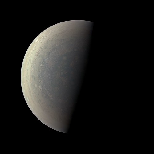
Here is a test image. This is image 119 ("radiation trend monitoring"). It was obtained on February 2, 2017 when Juno was ~340,000 km from Jupiter's center on the outbound leg of its trajectory. I selected this image because it's a global image where limb fits are trivial - this makes debugging stuff easier.
Click to view attachmentClick to view attachment
The left version is the image with almost no processing except for color correction and some sharpening. In the right version global illumination has been removed using a modified Lommel-Seeliger function and the contrast greatly exaggerated. In the original images the area near Jupiter's right limb is saturated in the red and green channels, resulting in very low contrast and slightly strange color. Interestingly, the saturated value in the original raw images is 240.
The contrast is rather low. I suspect I need to add square root encoding to the processing to increase the contrast; I noticed that Gerald does this.
One thing that caused me some minor headaches was a part the SPICE instrument kernel file, specifically this section:
Maybe I'm missing something elementary but the value 61.69 deg seems strange and I get weird results if I use it. However, a 58.015 deg field of view for all 1648 pixels works perfectly and is also consistent with the 58 deg value for JunoCam that I've seen elsewhere and it's also consistent with JunoCam's focal length and pixel size.
As usual a big part of the work involved correcting the pointing. I used SPICE kernels and software I wrote using the SPICE toolkit to get the spacecraft position and pointing and to optionally correct the pointing (somewhat comparable to what the ISIS3 deltack program does). For the interested, here is an example of the output. It's somewhat similar to a PDS label file but with some 'new' custom labels that I added.
Next: Processing a much closer and higher resolution image of Jupiter.
Here is a test image. This is image 119 ("radiation trend monitoring"). It was obtained on February 2, 2017 when Juno was ~340,000 km from Jupiter's center on the outbound leg of its trajectory. I selected this image because it's a global image where limb fits are trivial - this makes debugging stuff easier.
Click to view attachmentClick to view attachment
The left version is the image with almost no processing except for color correction and some sharpening. In the right version global illumination has been removed using a modified Lommel-Seeliger function and the contrast greatly exaggerated. In the original images the area near Jupiter's right limb is saturated in the red and green channels, resulting in very low contrast and slightly strange color. Interestingly, the saturated value in the original raw images is 240.
The contrast is rather low. I suspect I need to add square root encoding to the processing to increase the contrast; I noticed that Gerald does this.
One thing that caused me some minor headaches was a part the SPICE instrument kernel file, specifically this section:
CODE
--- 0,0---------------------|----------------------. | 230 pixels
4.94 deg | RED 128 pix * | --------
--- `----------------------|------------------1600,128
|
V +Yjc
| 61.69 deg | Boresight
|---------------------------------------------| (+Zjc axis)
| | is into
the page
4.94 deg | RED 128 pix * | --------
--- `----------------------|------------------1600,128
|
V +Yjc
| 61.69 deg | Boresight
|---------------------------------------------| (+Zjc axis)
| | is into
the page
Maybe I'm missing something elementary but the value 61.69 deg seems strange and I get weird results if I use it. However, a 58.015 deg field of view for all 1648 pixels works perfectly and is also consistent with the 58 deg value for JunoCam that I've seen elsewhere and it's also consistent with JunoCam's focal length and pixel size.
As usual a big part of the work involved correcting the pointing. I used SPICE kernels and software I wrote using the SPICE toolkit to get the spacecraft position and pointing and to optionally correct the pointing (somewhat comparable to what the ISIS3 deltack program does). For the interested, here is an example of the output. It's somewhat similar to a PDS label file but with some 'new' custom labels that I added.
CODE
/* Spicegeom version 2017-02-28 */
TARGET_NAME="Jupiter"
SPACECRAFT_NAME="Juno"
IMAGE_NUMBER=" -1"
IMAGE_TIME="2017-FEB-02 15:57:44.297"
SC_TARGET_POSITION_VECTOR=(-148470.35180453,63094.92703727,-301286.56346215)
TARGET_CENTER_DISTANCE=341757.236215459
SUB_SPACECRAFT_LATITUDE=-61.833627009783
SUB_SPACECRAFT_LONGITUDE=203.026167185770
SUB_SPACECRAFT_LINE_SAMPLE=832.2795709754
SUB_SPACECRAFT_LINE=738.4562742541
SAMPLE_TO_BE_CORRECTED=494.0000000000
LINE_TO_BE_CORRECTED=753.0000000000
SAMPLE_CORRECTION=-20.0000000000
LINE_CORRECTION=7.0000000000
NORTH_AZIMUTH=90.45299584
FIELD_OF_VIEW=58.01500000
/* LOOK_AT includes a possible user-specified correction to LINE[_SAMPLE] */
/* In contrast, SUB_SPACECRAFT_LINE[_SAMPLE] does not include this correction */
LOOK_AT_X=-143367.5394205331
LOOK_AT_Z=-292943.9225293422
LOOK_AT_Y=61006.4711387579
PLANETOGRAPHIC_SUB_SPACECRAFT_LATITUDE=-64.90958822
SUB_SOLAR_LATITUDE=-2.582962
SUB_SOLAR_LONGITUDE=100.197161
SOLAR_DISTANCE=815580051.923982
PLANETOGRAPHIC_SUB_SOLAR_LATITUDE=-2.953164
PHASE_ANGLE=93.724392
Next: Processing a much closer and higher resolution image of Jupiter.
QUOTE (Bjorn Jonsson @ Mar 6 2017, 04:24 PM)
Maybe I'm missing something elementary but the value 61.69 deg seems strange and I get weird results if I use it.
61.69 is simply the crosstrack FOV if the camera were a perfect pinhole camera with the given pixel pitch and focal length; i.e., degrees(1600*7.4e-3/10.997) = 61.69.
Of course, the camera is not a perfect pinhole camera so you shouldn't expect the 61.69 to be particularly meaningful; it's in a comment after all.
The I kernel (and the frames kernel for Junocam) are admittedly works in progress. I hope to have another update in a few months.
QUOTE (Bjorn Jonsson @ Mar 7 2017, 01:24 AM)
The contrast is rather low. I suspect I need to add square root encoding to the processing to increase the contrast; I noticed that Gerald does this.
The square root encoding returns low contrast, similar to the raws, but it covers most of the dynamical range of "natural" colors.
One option I'm using to enhance the images is a gamma-stretch of the illumination-adjusted version, by a gamma of 4 with respect to the square-root encoded version, i.e. by using the square of the (approximately) radiometrically calibrated data.
In your enhanced image, I see, that you get color banding, as others including me, had been getting for quite a period of time. That's due to the piece-wise linear de-companding function, substantially deviating from square-root encoding.
Your Lommel-Seeliger model seems to work considerably better than the very simple Lambert model I'm using. Thanks for this hint! I've been going to infer the illumination model empirically.
QUOTE (Gerald @ Mar 7 2017, 08:26 AM)
In your enhanced image, I see, that you get color banding, as others including me, had been getting for quite a period of time. That's due to the piece-wise linear de-companding function, substantially deviating from square-root encoding.
Your Lommel-Seeliger model seems to work considerably better than the very simple Lambert model I'm using. Thanks for this hint! I've been going to infer the illumination model empirically.
Your Lommel-Seeliger model seems to work considerably better than the very simple Lambert model I'm using. Thanks for this hint! I've been going to infer the illumination model empirically.
I found the SQROOT companding table and added it to my software - I'm now getting greatly improved results by decompanding the data. Here is first a simple cylindrical map with global illumination removed. Latitude is planetographic. Lommel-Seeliger works better than simple Lambert, especially in the modified form I'm using. The modification is to apply an exponent to the cosines of the incidence and emission angles. I'm currently using a value of 1.1 but this can probably be improved slightly. I also experimented with a Backstorm function but it probably doesn't work as well as modified Lommel-Seeliger (I need to check this more carefully though).
Click to view attachment
It should be noted that to correct the color where R/G is saturated I made some manual modifications to the map in Photoshop and I also made minor adjustments near the terminator.
And here are new versions of the images I posted yesterday. These new versions are significantly better.
Click to view attachmentClick to view attachment
The color correction I'm using is preliminary (without it the images are far too yellowish). It will probably change a bit but nevertheless this shouldn't be too far from Jupiter's true color.
This is a "lo-fi" version of our main content. To view the full version with more information, formatting and images, please click here.