New images released!
And raw images at various processing levels from PJ1 are now in the JunoCam gallery.
Full Version: Perijove 1 (PJ1)
I found the gallery view on the website a little confusing, so I've downloaded all the data and stuck it all in a single zip file here. I also took the liberty of renaming the metadata files to match the file name convention for the image files they are associated with.
QUOTE (elakdawalla @ Sep 2 2016, 08:45 AM) 
New images released!
Our long national nightmare is over.

New thread for perijove data? (Although the "marble movie" will continue for orbit 1 outbound and orbit 2 inbound.)
Good idea! It'll help to keep the Marble Movie and PJ1 conversations separated.
QUOTE (elakdawalla @ Sep 2 2016, 12:11 PM)
I found the gallery view on the website a little confusing, so I've downloaded all the data and stuck it all in a single zip file here. I also took the liberty of renaming the metadata files to match the file name convention for the image files they are associated with.
Thank you Emily. Is it just me, or is the color balance off on the latest processed versions? Looks too yellow to me, whereas the pole areas always appear more gray in most amateur images. I used that as the basis for my color decisions earlier, though I'm just eyeballing it.
The color clearly needs to be adjusted.
I've now made a browse page to the PJ1 data.
Note that today's release also includes the Ganymede image we were expecting from August 26.
I've now made a browse page to the PJ1 data.
Note that today's release also includes the Ganymede image we were expecting from August 26.
Thanks for the compilation, Emily.
Some features in the closest images that at first I thought might be tall-cloud shadow streaks:
Click to view attachment
But they don't seem to be orthogonal to the terminator (unless there's something really weird about the projection geometry...), so probably just cloud features.
Some features in the closest images that at first I thought might be tall-cloud shadow streaks:
Click to view attachment
But they don't seem to be orthogonal to the terminator (unless there's something really weird about the projection geometry...), so probably just cloud features.
QUOTE (S_Walker @ Sep 2 2016, 09:35 AM)
is the color balance off on the latest processed versions?
There is no color balancing of any kind done for the gallery processing, this is the raw color out of the camera.

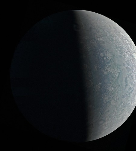
Here is a quick and dirty enhancement of image JNCE_2016240_00C06163_V01-mapprojected.png:
Click to view attachment
This image looks like it was intentionally overexposed to better reveal details near the terminator. One particularly interesting feature is visible near the bottom where clear vertical relief seems to be visible (I don't think this is an artifact). There seems to be an elevated cloud at the terminator - it appears much brighter than other features at the terminator and may even extend to the nightside (I don't know the exact location of the terminator but should be able to determine it later). There is a dark feature left of it that looks like a 'depression' (could also be a dark cloud feature). One thing I find striking about this image and the other polar images is the large number of roughly circular storm systems.
I don't know when this image was obtained or at what range. The label file (JSON file) seems to be corrupt and contains no data of interest, just "<Error><Code>NoSuchKey</Code><Message>The specified key does not exist.</Message>..." etc.
EDIT: Now I notice that Emily's index page includes the distance from Jupiter, it is 70380 km. I was far too excited about these new images to notice this!
QUOTE (Bjorn Jonsson @ Sep 2 2016, 11:55 AM)
This image looks like it was intentionally overexposed to better reveal details near the terminator.
The label file (JSON file) seems to be corrupt and contains no data of interest...
The label file (JSON file) seems to be corrupt and contains no data of interest...
This is one of the aurora search images. (We didn't see the aurora, BTW.) I was hoping that the RATIONALE_DESC field in the metadata would have more detail but it doesn't look like that was done for this release. Keep in mind that this is the first time we've published real data to missionjuno so there are still some kinks to work out.
The (admittedly klunky) metadata download worked for me for this image.
CODE
{
"COMPRESSION_TYPE": "INTEGER COSINE TRANSFORM",
"DATA_SET_ID": "JUNO-J-JUNOCAM-2-EDR-L0-V1.0",
"EXPOSURE_DURATION": "51.200000 <ms>",
"FILE_NAME": "JNCE_2016240_00C06163_V01-raw.png",
"FILE_RECORDS": 9216,
"FILTER_NAME": [
"BLUE",
"GREEN",
"RED"
],
"FOCAL_PLANE_TEMPERATURE": "273.0 <K>",
"IMAGE_TIME": "2016-08-27T12:00:44.127",
"INSTRUMENT_HOST_NAME": "JUNO",
"INSTRUMENT_ID": "JNC",
"INSTRUMENT_NAME": "JUNO EPO CAMERA",
"INTERFRAME_DELAY": "0.378 <s>",
"JNO:TDI_STAGES_COUNT": 16,
"LINES": 9216,
"LINE_PREFIX_BYTES": 0,
"LINE_SAMPLES": 1648,
"LINE_SUFFIX_BYTES": 0,
"MISSION_PHASE_NAME": "PERIJOVE 1",
"ORBIT_NUMBER": 1,
"PJ": "01",
"PROCESSING_LEVEL_ID": 2,
"PRODUCER_ID": "JUNO_JUNOCAM_TEAM",
"PRODUCT_CREATION_TIME": "2016-09-01T14:08:33",
"PRODUCT_ID": "JNCE_2016240_00C06163_V01",
"PRODUCT_VERSION_ID": 1,
"RATIONALE_DESC": "Jupiter imaging",
"RECORD_BYTES": 1648,
"SAMPLE_BITS": 8,
"SAMPLE_BIT_MASK": "2#11111111#",
"SAMPLE_BIT_MODE_ID": "SQROOT",
"SAMPLE_TYPE": "UNSIGNED_INTEGER",
"SAMPLING_FACTOR": 1,
"SEQUENCE_ID": "jm0003",
"SOFTWARE_NAME": "JUNOMAKEPDS.PY 0.4",
"SOLAR_DISTANCE": "8.1519e+08 <km>",
"SOURCE_PRODUCT_ID": "3D-0900011813-2016-240T15.38.52",
"SPACECRAFT_ALTITUDE": "70379.5 <km>",
"SPACECRAFT_CLOCK_START_COUNT": "525571420:91",
"SPACECRAFT_CLOCK_STOP_COUNT": "N/A",
"SPACECRAFT_NAME": "JUNO",
"STANDARD_DATA_PRODUCT_ID": "JUNOCAM-EDR",
"START_TIME": "2016-08-27T12:00:44.127",
"STOP_TIME": "2016-08-27T12:00:53.199",
"SUB_SPACECRAFT_LATITUDE": "88.4528",
"SUB_SPACECRAFT_LONGITUDE": "70.4651",
"TARGET_NAME": "JUPITER",
"TOKEN_ID": [
""
]
}
QUOTE (Bjorn Jonsson @ Sep 2 2016, 12:55 PM)
I don't know when this image was obtained or at what range. The label file (JSON file) seems to be corrupt and contains no data of interest, just "<Error><Code>NoSuchKey</Code><Message>The specified key does not exist.</Message>..." etc.
Sounds like a bad link on my S3 page, I will fix this.
Edit: Fixed. Sorry!
QUOTE (mcaplinger @ Sep 2 2016, 08:06 PM)
The (admittedly klunky) metadata download worked for me for this image.
Thanks for the metadata - lots of useful information there. I downloaded the file I have from Emily's index page, maybe something is wrong there.
EDIT: Yes, Emily confirms this in the post above.
EDIT2: It has now been fixed.
Processed version of JNCE_2016240_00C06182_V01
Click to view attachment
Click to view attachment
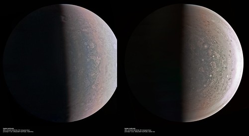
Here is a quick and dirty enhancement/processing of image JNCE_2016240_00C06164_V01-mapprojected.png:
Click to view attachment
I didin't pay much attention to the color balance, I simply wanted to bring out various small scale features, especially near the terminator. Significant vertical relief/shadows seems to be visible near the terminator. For example, the feature at (777,1475) is probably real (a short 'wall' roughly parallel to the terminator). Several big, 'depression-like' features are visible near the terminator, especially in the lower half of the image. The processing has also revealed compression artifacts.
This image was obtained at a range of 36859 km from Jupiter's cloud tops, resulting in a resolution of ~20 km/pixel at the nadir.
BTW, the map projection in use is a point-perspective from the altitude in the metadata that's always 1600x1600 pixels in size and centered on the lat/lon shown in the metadata. We're still working on the fine pointing calibration so there may be errors on the order of a few pixels absolute and color-to-color.
After the recent 7/24, here two more relaxing (for me) crops, rendered from the raws, a moon; if I understand right, it should be Ganymede (60 pixels / deg):
Click to view attachment
And a crop of #06160, showing the bright limb, in contrast to the limb darkening as seen from Earth, and a confirmation from my side of the distinct cloud topography near the terminator (120 pixels / deg):
Click to view attachment
The limb at the terminator might be of a greenish cast, but I'm not entirely sure, whether this could also be a camera or processing artifact.
Ignoring distance, shape, and rotation of Jupiter, as well as the spacecraft trajectory, didn't cause much misalignment in these images.
Since I didn't reproject the images, you can see the limb close to real.
The images are so fascinating, that I almost forgot to post.
Click to view attachment
And a crop of #06160, showing the bright limb, in contrast to the limb darkening as seen from Earth, and a confirmation from my side of the distinct cloud topography near the terminator (120 pixels / deg):
Click to view attachment
The limb at the terminator might be of a greenish cast, but I'm not entirely sure, whether this could also be a camera or processing artifact.
Ignoring distance, shape, and rotation of Jupiter, as well as the spacecraft trajectory, didn't cause much misalignment in these images.
Since I didn't reproject the images, you can see the limb close to real.
The images are so fascinating, that I almost forgot to post.
I've made my RGB version of JNCE_2016240_00C06160_V01 image
...Emily, thanks for Juno catalog is very usable
...Emily, thanks for Juno catalog is very usable
This thread has the compact and cryptic name "PJ1". YOU all know that means "this is the thread where we process and discuss the results from Perijove 1", but the average reader will not, and may miss this thread entirely as a result.
May I suggest that this thread be renamed "Results from Jupiter flyby Perijove 1 (PJ1)"? I know it's perhaps inaccurate to call it a flyby, but I think it's important to have some sort of words like that in the thread title.
And of course future threads (PJ2, PJ3, etc.) would be similarly named.
MOD: Done.
Enhanced and sharpened version of #06182 reprojected to hide a missing part.
Click to view attachment
Click to view attachment
I add the north (second version) and south poles together
Heavily compressed and reduced 61-frames gif animation of raw #06160, 100x time-lapsed (5 real seconds per frame, animated with 20 fps) :
Click to view attachment
That's been a first test run.
The simulated trajectory should be similar to the real one, however with a small discrepancy, which I'll try to fix for the full version.
(credit: NASA / JPL / SwRI / MSSS / SPICE / Gerald Eichstädt)
Click to view attachment
That's been a first test run.
The simulated trajectory should be similar to the real one, however with a small discrepancy, which I'll try to fix for the full version.
(credit: NASA / JPL / SwRI / MSSS / SPICE / Gerald Eichstädt)
Hi all.
I'm not sure if this should be posted in this thread... first post of mine, anyway, after years registered. I think it would be didactic to compare Earth with Jupiter in the polar images and then made this (posted in a blog, but I don't know if it would be nice to put url here).
Click to view attachment
(Credit: NASA / JPL / SwRI / MSSS / NEAR-Shoemaker / Crastinia)
QUOTE (xosema @ Sep 4 2016, 12:12 PM)
I think it would be didactic to compare Earth with Jupiter in the polar images...
Very pretty, nice idea! To be picky, the Junocam polar image doesn't cover the entire planet since it's a point perspective from a relatively low altitude (it only covers from the south pole to about 30 degrees south) -- so your image is a bit misleading about the scale of things across the planet.
p.s. should be in PJ1 thread. [MOD: DONE.]
1500-fold timelapse AVI (one frame per real-time minute, animated with 25 fps) of image #06160, again 61 frames, better quality than gif:
Click to view attachment
Click to view attachment
One of my processed south-polar images of Jupiter, derived from raw JunoCam image #06186:
Click to view attachment
Access to supersampled version with 120 pixels/degree.
Click to view attachment
Access to supersampled version with 120 pixels/degree.
QUOTE (Gerald @ Sep 4 2016, 04:45 PM)
1500-fold timelapse AVI (one frame per real-time minute, animated with 25 fps) of image #06160, again 61 frames, better quality than gif:
Click to view attachment
Click to view attachment
This is really cool - will make a great movie once it's complete!
Yes, there is quite a lot in the images waiting for being squeezed out.
Derived from image #06166, an idea of a flyover, each frame rendered directly from the raw:
Click to view attachment
According to the JunoCam paper,
So the above example shows only the feasability without modeling the cloud topography.
I've too large inconsistencies at the moment to seriously try stereo imaging or methane band analysis.
Via spy.exe I don't get an x-position for the Sun or Earth in the JunoCam frame. So I'm using Jupiter and Jupiter_Barycenter in J2000 and Juno_JunoCam to infer a transformation matrix between a fixed JunoCam pointing and J2000; this provides a transformation from the J2000 trajectory data to my chosen JunoCam frame.
But Jupiter and Jupiter_Barycenter are almost identical, so I might have run into some numerical instability, since the resulting base of the vector space is almost singular.
Another cause for the inconsistencies may be the simplistic spherical model for Jupiter, which is waiting to be replaced by a spheroid.
The third possible cause is, that I'm using preliminary SPICE trajectory data.
To accomodate for the inconsistency, I need to choose the x-value of optical center of the camera dependent of the image, in the above case at x=700, which results in some noticeable rgb misalignment.
I'll begin with reducing my own obvious inaccuracies, and if this doesn't resolve the inconsistencies, I'll check the data sources.
Derived from image #06166, an idea of a flyover, each frame rendered directly from the raw:
Click to view attachment
According to the JunoCam paper,
QUOTE
when stereo is available we will encourage the making of visualization products like flyovers.
So the above example shows only the feasability without modeling the cloud topography.
I've too large inconsistencies at the moment to seriously try stereo imaging or methane band analysis.
Via spy.exe I don't get an x-position for the Sun or Earth in the JunoCam frame. So I'm using Jupiter and Jupiter_Barycenter in J2000 and Juno_JunoCam to infer a transformation matrix between a fixed JunoCam pointing and J2000; this provides a transformation from the J2000 trajectory data to my chosen JunoCam frame.
But Jupiter and Jupiter_Barycenter are almost identical, so I might have run into some numerical instability, since the resulting base of the vector space is almost singular.
Another cause for the inconsistencies may be the simplistic spherical model for Jupiter, which is waiting to be replaced by a spheroid.
The third possible cause is, that I'm using preliminary SPICE trajectory data.
To accomodate for the inconsistency, I need to choose the x-value of optical center of the camera dependent of the image, in the above case at x=700, which results in some noticeable rgb misalignment.
I'll begin with reducing my own obvious inaccuracies, and if this doesn't resolve the inconsistencies, I'll check the data sources.
QUOTE (Gerald @ Sep 5 2016, 05:39 PM)
Via spy.exe I don't get an x-position for the Sun or Earth in the JunoCam frame.
I have to confess I'm not sure what you're trying to accomplish here, but if you're not getting a result, it means that you don't have all of the needed kernel files loaded or they don't cover the time range of interest.
Strangely, I get y and z-position, but something like "******" for x.
But thanks, verifying the kernels for completeness once more, is a good idea.
I'm trying to convert a J2000 Juno trajectory dump into a trajectory for a JunoCam position and pointing for a fixed instant. My rendering and reprojection algorithms are operating with such a settings. This worked well with EFB using Earth and Moon seen from JunoCam and J2000 as a basis for coordinate transformation from a J2000 trajectory dump to a fixed or variable JunoCam position. I'm just applying some basic linear algebra, a change of basis.
EDIT: (LOL!) I think I've got it:
hasn't been able to code the distance Jupiter - Sun. Instead
should do it.
Good idea to review the spy script. Looked for missing kernels and found inappropriate number format.
Edit2: At first glance, things make more sense now.
One of the goals I'm trying to accomplish, is reprojecting different raw images to the same perspective, for several subsequent goals. Some of them are
- continuous movies over more than one raw image,
- looking for changes between subsequent images,
- matching cloud topography information from CH4 images with RGB images.
But thanks, verifying the kernels for completeness once more, is a good idea.
I'm trying to convert a J2000 Juno trajectory dump into a trajectory for a JunoCam position and pointing for a fixed instant. My rendering and reprojection algorithms are operating with such a settings. This worked well with EFB using Earth and Moon seen from JunoCam and J2000 as a basis for coordinate transformation from a J2000 trajectory dump to a fixed or variable JunoCam position. I'm just applying some basic linear algebra, a change of basis.
EDIT: (LOL!) I think I've got it:
QUOTE
SET NUMBER FORMAT F18.8
hasn't been able to code the distance Jupiter - Sun. Instead
QUOTE
SET NUMBER FORMAT F20.8
should do it.
Good idea to review the spy script. Looked for missing kernels and found inappropriate number format.
Edit2: At first glance, things make more sense now.
One of the goals I'm trying to accomplish, is reprojecting different raw images to the same perspective, for several subsequent goals. Some of them are
- continuous movies over more than one raw image,
- looking for changes between subsequent images,
- matching cloud topography information from CH4 images with RGB images.
An enhanced crop of a processed raw JNC #06166 shows, that RGB alignment is good now, despite the inaccurate shape model:
Click to view attachment
Time for fine-tuning, and for focusing on deriving common perspective for two different raw images.
Click to view attachment
Time for fine-tuning, and for focusing on deriving common perspective for two different raw images.
This is just Gerald's image processed to emphasise cloud patterns, especially near the terminator.
Phil
Click to view attachment
Phil
Click to view attachment
I get a resolution of ~14km/px for that image (altitude 19,900km) - not sure if it's correct.
Just for comparison the Voyager images that Bjorn posted here have a resolution of ~5km/px - it's amazing to see what look like thunderclouds (?) on top of the other clouds -
http://www.unmannedspaceflight.com/index.p...st&p=232324
It'll be great if it catches some interesting clouds in future orbits at the higher resolutions - I read somewhere also that future images might be better as the perijoves will be more in the sun.
Once you know of the corresponding cloud structures between images #06160 and #06166
Click to view attachment
you can find those in the hazy reprojections of similar perspective:
Click to view attachment Click to view attachment
Not very easy, but feasible.
Besides the change of perspective, there might even be discernible some real motion. To decide this unambiguously, more accurate processing may be required. But it's at least a first step towards measuring cloud dynamics.
QUOTE (Gerald @ Sep 6 2016, 09:50 PM)
Besides the change of perspective, there might even be discernible some real motion. To decide this unambiguously, more accurate processing may be required. But it's at least a first step towards measuring cloud dynamics.
From my experience with Voyager images (and also from reading some Voyager Jupiter papers), cloud motions can be measured/detected in images taken ~30 minutes apart once the resolution is ~15 km/pixel or better. Of course this depends on how big the changes are - the winds are probably slower in the polar regions than closer to the equator, at least the east/west winds are slower.
Sorry for a short interruption of the JunoCam image processing, but
-- when googling for Juno, I come repeatedly across references to and citations of the recent press release of PJ1 stating
With a data rate of 119.56 kb/s,
Click to view attachment
this sounds like an understatement by at least two orders of magnitude,
since 119.56 kb/s x 36 x 3600s = 15.4e6 kb = 1.9e6 kB = 1.9 GB >> 4 MB.
If the data have been compressed, and only occasional error corrections have become necessary, the decompressed data should have been closer to 4 GB.
---
Regarding the winds, we have now the opportunity to verify or adjust the models of the polar wind systems. I'd think, that within vortices wind velocities can be much higher than mean regional or global winds. I'm curious, what we can find out. A pixel isn't necessarily the accuracy limit for displacement measurements. It depends much on the actual structure of the respective clouds.
-- when googling for Juno, I come repeatedly across references to and citations of the recent press release of PJ1 stating
QUOTE
The download of six megabytes of data collected during the six-hour transit, from above Jupiters north pole to below its south pole, took one-and-a-half days.
With a data rate of 119.56 kb/s,
Click to view attachment
this sounds like an understatement by at least two orders of magnitude,
since 119.56 kb/s x 36 x 3600s = 15.4e6 kb = 1.9e6 kB = 1.9 GB >> 4 MB.
If the data have been compressed, and only occasional error corrections have become necessary, the decompressed data should have been closer to 4 GB.
---
Regarding the winds, we have now the opportunity to verify or adjust the models of the polar wind systems. I'd think, that within vortices wind velocities can be much higher than mean regional or global winds. I'm curious, what we can find out. A pixel isn't necessarily the accuracy limit for displacement measurements. It depends much on the actual structure of the respective clouds.
QUOTE (Gerald @ Sep 6 2016, 04:50 PM)
this sounds like an understatement by at least two orders of magnitude,
I didn't write this part of the press release so I can't say what was intended, but a few points:
1) Not all passes are to 70m antennas. To the 34m HEF subnet the data rate is only 22 kbit/sec. And DSN passes weren't continuous through this period, especially because some of the 70m time was lost to STEREO B.
2) Junocam only gets a small fraction of the total downlink rate (about 5%) with the remainder going to the rest of the payload.
3) Any dropped packets during transmission have to be explicitly commanded to be retransmitted, which takes a day or so typically.
Hi all,
Ive recently started a few experiments in using Visual Effects software to process/align raw space imagery - specifically from the Voyager/JUNO missions. I've spent a few hours over the last few days attempting to resolve my own image of Jupiters poles using the raw images from PJ1 and some common VFX techniques, and whilst Ive still got a long way to go (Im constantly in awe of the quality of work posted here) I thought Id post my first results. All credits of course go to NASA/SwRI/MSSS.


I'm a lot happier with the south pole image (JNCE_2016240_00C06186_V01-raw), as the north pole image (JNCE_2016240_00C06162_V01-raw) sadly seems to contain more compression artefacts. I'd love to get my hands on the NON-PNG versions
Again, thanks for posting such incredible imagery.
Cheers!
Matt
The compression artifacts are probably present in the original data as transmitted from the spacecraft. I think the plan for PJ1 was to experiment with different compression levels in order to find the right balance between number of images and image quality within JunoCam's limited data volume budget.
Nice looking work, especially for a first post! You might want to fiddle with the color a bit (you can use Bjorn's work from the Voyager threads for guidance) since we know the raw stuff out of JunoCam is noticeably yellow.
Nice looking work, especially for a first post! You might want to fiddle with the color a bit (you can use Bjorn's work from the Voyager threads for guidance) since we know the raw stuff out of JunoCam is noticeably yellow.
QUOTE (Matt Brealey @ Sep 7 2016, 08:56 AM)
I'd love to get my hands on the NON-PNG versions
PNG is lossless, so you are not losing anything. Any compression artifacts are there in the images as received. The south polar images were transmitted lossless (metadata notwithstanding, there's a bug in how we report that.)
BTW, this is pretty remarkable processing; more detail about how you did it would be interesting.
elakdawalla : Thanks very much! To be honest I hadnt really considered that the colour would be anything other than the result of the merged rgb channels. Ill take a look at Bjorns work now, as if I can find suitable reference for the actual offset required, applying it should be relatively straightforward (famous last words
)
And that makes a lot of sense about the compression. Itd be very interesting to see a comparison of the different levels (as much as that would be possible with different features in frame).
mcaplinger : Gotcha. And thanks! Ill be writing it up over at thestateofspace in the next few days, but the short version is that I use a piece of industry-standard compositing software called Nuke to isolate the individual elements of the raw image, remove calibration marks, stitch/align the RGB channels and then merge everything back together. Im slightly amazed at how suitable the software actually is to this kind of work! Ill be sure to post a link here (if thats not against the rules) when the article is posted.
As an aside, Ive also recently used the same application to auto-process the JUNO approach data, (producing a single 1648x128 RGB frame per raw image that looks a little like the attached) and then stitch it together into a crude version of the approach movie! Though Im not quite ready to show that one just yet
Cheers!
Click to view attachment
Hi Matt, I've seen your work before on imgur. Intersting approach. As far as I understand, you are working merely in 2d. That's an approach similar to the one I've used for my first EFB processings in 2013. It's always astonishing, that it works without 3d information.
In the meanwhile I've composed a synopsis of the 16 RGB images of PJ1, in a level 1 style:
Click to view attachment
(credit: NASA / JPL / SwRI / MSSS / Gerald Eichstädt)
That's a 7.5 pixels/degree version.
This version doesn't use 3d data either, except camera and spacecraft angular velocity parameters, the same method as for my Marble Movie level 1 processings.
I'd think that it works reasonably well, because Juno's trajectory has been almost parallel to the line Juno - Jupiter.
I may notify later in this post, when I've uploaded the 30 pixel/degree png version.
EDIT: Upload completed.
In the North Pole image of Matt's are a couple almost-linear large scale features unlike anything I have seen on Jupiter before.
They are not the least bit subtle - easily exceeding one Earth diameter in length.
One is centered in the image and nearly horizontal. It looks almost like a ridge. The other is to the right and lower down, and looks more like a groove.
Are these suspected to be artifacts? Otherwise, I would be scratching my head to figure out how they could develop and persist in a gassy environment.
QUOTE (tanjent @ Sep 7 2016, 05:57 PM)
In the North Pole image of Matt's are a couple almost-linear large scale features unlike anything I have seen on Jupiter before.
https://en.wikipedia.org/wiki/Rossby_wave as noted in the press release https://www.nasa.gov/image-feature/jpl/pia1...ters-north-pole
That has been one of the first things that jumped into my eyes, too, when I enhanced the last pre-PJ1 marble movie image.
But at that time I hadn't yet considered the laminar feature as a jet stream feature. I first thought, it would separate two regions of turbulence.
With the higher-resolved images however, one can perceive, that the laminar and the turbulent cloud features overlap. So it need to be two different cloud/haze layers.
A 4-fold reduced level-2 version of the PJ1 JunoCam color images:
Click to view attachment
I'm going to prepare the 30 pixels/degree version for upload. I'd think, this will take another hour or two.
Click to view attachment
I'm going to prepare the 30 pixels/degree version for upload. I'd think, this will take another hour or two.
Level 2, 30 pixel / degree PJ1 images are uploaded.
Image #06104 is of sufficiently small file size, that I can post it directly:
Click to view attachment
It should show Jupiter, Io, Europa, and Ganymede.
Io and Europa are small dots in this image.
Image #06104 is of sufficiently small file size, that I can post it directly:
Click to view attachment
It should show Jupiter, Io, Europa, and Ganymede.
Io and Europa are small dots in this image.
Gerald : Thanks! You’re absolutely right that (at least so far) everything I’ve put together has been through working purely in 2D. I did initially grab some data from Horizons to actually model Jupiter/PJ1 in 3D, however I couldn’t find a good source for JUNOs rotation at any point along it’s path.
Interestingly, re-projection of image data onto a base geometry is actually a very common technique in VFX, and if I can find a suitable way of modelling JUNOs actual position/rotation I’m very interested in exploring it further as we get access to the next set of data!
I also wanted to quickly say that your images are consistently phenomenal, and I must admit to being slightly in awe of the technical knowledge that goes into them! That last image of Jupiter is, of course, no exception. Amazing work!
tanjent/mcaplinger/Gerald : The Rossby waves did confuse me slightly as well when I put the images together! Thanks for the explanation - I have so much interesting reading to do
Cheers!
Matt
Matt, your de-lamberted versions remind me, that I'm still at the very beginning of JunoCam data reduction.
You really found a quick way to get managed raw JunoCam data. In 2013 it took me more than a week to get acceptable results.
Regarding 3d:
You may go the tedious photogrammetric way, or use the available 3d data.
There is still some time until Juno's science orbits to learn more about SPICE.
Login via ftp to anonymous@naif.jpl.nasa.gov and change directory to /pub/naif/JUNO/kernels to get access to the 3d data. Usually you need only the newest files in each of the directories. However Juno's precise camera distortions are a matter of ongoing investigation.
QUOTE (Matt Brealey @ Sep 8 2016, 08:38 AM)
everything Ive put together has been through working purely in 2D.
Frankly the results are cosmetically better than what we are getting with the full 3D solution, so why change anything if it's not broken? As the spacecraft gets closer to the planet and its position is changing more across the image acquisition, the 2D solution may break down. And with 2D you probably don't have a good mapping to absolute lat/lon. But for visual examination your products are IMHO the best so far! Of course a lot of that is the sharpening and photometric removal; I'm very interested to get more details about your workflow for that.
This is a "lo-fi" version of our main content. To view the full version with more information, formatting and images, please click here.