I've been searching a bit, but I haven't found anything: is there a quick method to get the geographic coordinates of any given point within a CTX observation?
I note that the right-click option "Copy Coordinates" in HiView gives the geographic coordinates for HiRISE images when drag-and-drop is used (as opposed to JPEG2000 downloads, when it just gives the pixel coordinates). Is there a way to use the drag-and-drop method for CTX imagery as well, perhaps?
The reason I am asking is that some HiWish targets are a bit tricky to place with visual guidance only.
Full Version: Extracting coordinates from CTX observations
ingest the CTX pds image into ISIS3 , then run spiceint on the image
then view in Qview or in QGis ( ArcGis can too but it is VERY EXPENSIVE )
every pixel will be Geo-referanced
example:
http://viewer.mars.asu.edu/planetview/inst...01S078W&T=2
the pds img ( 197.5 MiB)
http://pds-imaging.jpl.nasa.gov/data/mro/m..._XN_01S078W.IMG
and the HiRISE in the ctx image
http://www.uahirise.org/ESP_038602_1770
the parts
http://hirise-pds.lpl.arizona.edu/PDS/EDR/...SP_038602_1770/
( needs a 10 to 15 gig of drive space for the working directory to assemble and calibrate the 18 RED parts - hirise images are BIG )
mroctx2isis
now there is a georeferenced image ( unmapped )
this one is near enough to the Equator
the default "sinusoidal" will do
( both the CTX and the HiRISE image MUST!!! use the same map file )
once the CTX and hirise are mapped to the same map file
you can then use "mapmos" to insert it into the ctx
or make a control network and use that
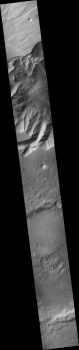
a 1/10 reduced size CTX image of the above example
( the hirise in the above will take a bit of time ( a few hours) even with my Automated script )
then view in Qview or in QGis ( ArcGis can too but it is VERY EXPENSIVE )
every pixel will be Geo-referanced
example:
http://viewer.mars.asu.edu/planetview/inst...01S078W&T=2
the pds img ( 197.5 MiB)
http://pds-imaging.jpl.nasa.gov/data/mro/m..._XN_01S078W.IMG
and the HiRISE in the ctx image
http://www.uahirise.org/ESP_038602_1770
the parts
http://hirise-pds.lpl.arizona.edu/PDS/EDR/...SP_038602_1770/
( needs a 10 to 15 gig of drive space for the working directory to assemble and calibrate the 18 RED parts - hirise images are BIG )
mroctx2isis
CODE
mroctx2isis from=P18_008234_1782_XN_01S078W.IMG to=P18_008234_1782_XN_01S078W.cub
spiceinit from=P18_008234_1782_XN_01S078W.cub
ctxcal from=P18_008234_1782_XN_01S078W.cub to=P18_008234_1782_XN_01S078W.Cal.cub
spiceinit from=P18_008234_1782_XN_01S078W.cub
ctxcal from=P18_008234_1782_XN_01S078W.cub to=P18_008234_1782_XN_01S078W.Cal.cub
now there is a georeferenced image ( unmapped )
this one is near enough to the Equator
the default "sinusoidal" will do
( both the CTX and the HiRISE image MUST!!! use the same map file )
CODE
cam2map from=P18_008234_1782_XN_01S078W.Cal.cub to=P18_008234_1782_XN_01S078W.Cal.Map.cub
once the CTX and hirise are mapped to the same map file
you can then use "mapmos" to insert it into the ctx
or make a control network and use that
a 1/10 reduced size CTX image of the above example
( the hirise in the above will take a bit of time ( a few hours) even with my Automated script )
Thanks. If there is no other way, I guess I'll look into it. (the UNIX requirement of ISIS 3 is inconvenient)
This is a "lo-fi" version of our main content. To view the full version with more information, formatting and images, please click here.