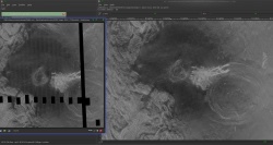
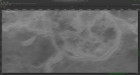
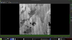
I have this .cub file of a section of Venus taken by Magellan that I got from map-a-planet2. Picture included below. You can see the striping effect. Does anyone know of a way to remove this banding effect easily in ISIS3 or another tool?
The best answer I have to far is using "Equalizer" in ISIS3
https://isis.astrogeology.usgs.gov/Applicat.../equalizer.html
Problem though is it looks like you have to fix it using the original striped input images before they are assembled into a .cub.
All I have though is the .cub that was already mosaicked.
Any suggestions on how to remove the striped effect at this point?
I dont believe those orginal individual striped images are avaible to public.
All I know of is the 130 gb .cub file found on mapaplanet2 from which this image was taken from.
thanks
dstripe in ISIS3 can remove striping but the problem is that the stripes have to be vertical or horizontal (maybe you could rotate the image before destriping?).
See https://isis.astrogeology.usgs.gov/Applicat...pe/dstripe.html
See https://isis.astrogeology.usgs.gov/Applicat...pe/dstripe.html
QUOTE (ncc1701d @ Feb 1 2016, 11:58 PM) 
I dont believe those orginal individual striped images are avaible to public.
Sure they are. They're called Full Resolution Basic Image Data Records or F-BIDRs. See http://pds-geosciences.wustl.edu/missions/magellan/
Getting rid of shading at the boundaries of the swaths was extremely difficult because of radar artifacts. Maybe in the 20+ years since I've looked at Magellan data someone has improved the processing.
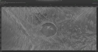
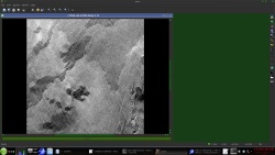
if you want i just gave a copy of my 131072x65536 pixel de striped Venus map to the Mesa Arizona CC planetarium
from the C1 data set
this will save you about 6 months or more of work
the black and white is 8 Gig the color is 24 gig in isis3 cub format and georeferenced
--
--
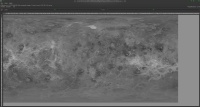
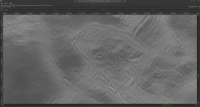
Dsrtipe is what i used after remapping to Mercator and rotating sections of the C1 data to vertical
( the strips are on a " s "curve )
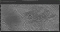
for the missing "No-data" areas i inpainted using the Resynthesizer plugin for gimp
combined with inpainting using the Greyc laboratories "Greystoration" tool
yes they are
the C1 is here
http://pds-imaging.jpl.nasa.gov/data/mgn-v...5-midr-c1-v1.0/
the FULLRES "F-BIDR"
http://pds-imaging.jpl.nasa.gov/data/mgn-v...-full-res-v1.0/
from the C1 data set
this will save you about 6 months or more of work
the black and white is 8 Gig the color is 24 gig in isis3 cub format and georeferenced
--
--
Dsrtipe is what i used after remapping to Mercator and rotating sections of the C1 data to vertical
( the strips are on a " s "curve )
for the missing "No-data" areas i inpainted using the Resynthesizer plugin for gimp
combined with inpainting using the Greyc laboratories "Greystoration" tool
QUOTE
I dont believe those orginal individual striped images are avaible to public.
yes they are
the C1 is here
http://pds-imaging.jpl.nasa.gov/data/mgn-v...5-midr-c1-v1.0/
the FULLRES "F-BIDR"
http://pds-imaging.jpl.nasa.gov/data/mgn-v...-full-res-v1.0/
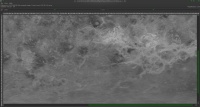
an example from the C1
http://pds-imaging.jpl.nasa.gov/data/mgn-v...0n335/c1f12.img
http://pds-imaging.jpl.nasa.gov/data/mgn-v...0n335/c1f12.lbl
use "qview's" tool measure for the angle
-- 5.6 in this case
( you will need to fix the mapping and extra border on the image after the second rotate
http://pds-imaging.jpl.nasa.gov/data/mgn-v...0n335/c1f12.img
http://pds-imaging.jpl.nasa.gov/data/mgn-v...0n335/c1f12.lbl
CODE
pds2isis from=c1f12.lbl image=c1f12.img to=c1f12.cub
use "qview's" tool measure for the angle
-- 5.6 in this case
CODE
rotate from=c1f12.cub to=work.cub degrees=5.6
CODE
dstripe from=work.cub to=work1.cub vlnl=137 vlns=3 vhnl=3 vhns=137
CODE
rotate from=work1.cub to=c1f12A.cub degrees=-5.6
( you will need to fix the mapping and extra border on the image after the second rotate
That's amazing, John. Somewhat on a tangent, could these techniques be utilized to clean-up the USGS Titan radar mosaic, as seen here:
http://astrogeology.usgs.gov/search/detail...n180_128ppd/cub
Furthermore, as someone who doesn't have access to ISIS, would the CUB file preserve the SAR swathes in separate layers?
http://astrogeology.usgs.gov/search/detail...n180_128ppd/cub
Furthermore, as someone who doesn't have access to ISIS, would the CUB file preserve the SAR swathes in separate layers?
ian
for that cub ?? no
if you work with each of the radar passes and mosaic then one at a time ?? then maybe ??
but "noseam" would be a better tool
back on target for the thread
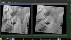
The dstripe tool works best on very regular noise and for it's intended use
-- see the images here
https://isis.astrogeology.usgs.gov/Applicat...pe/dstripe.html
for that cub ?? no
if you work with each of the radar passes and mosaic then one at a time ?? then maybe ??
but "noseam" would be a better tool
back on target for the thread
The dstripe tool works best on very regular noise and for it's intended use
-- see the images here
https://isis.astrogeology.usgs.gov/Applicat...pe/dstripe.html
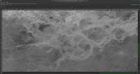
Given how well this worked, I'm surprised no one has gone back and reprocessed the whole C1-MIDR dataset like this. There's this -- http://www.celestiamotherlode.net/catalog/...p?addon_id=1070 -- but I haven't looked at it.
mcaplinger
that IS my map on the Celestia motherload
( libido also ask me not to host any more 12+ gig files )
in 2011 / 2012 over the winter i reworked the C1 data
that IS my map on the Celestia motherload
( libido also ask me not to host any more 12+ gig files )
in 2011 / 2012 over the winter i reworked the C1 data
QUOTE (JohnVV @ Feb 3 2016, 12:49 PM)
in 2011 / 2012 over the winter i reworked the C1 data
Is the georeferenced CUB version online anywhere? Maybe USGS should be using that since it's so much better than the original version.
my large map is here:
-- do to age the below links do not work
if someone needs it PM me
https://drive.google.com/file/d/0B6ZYAd08tZ...iew?usp=sharing
and
https://drive.google.com/open?id=0B6ZYAd08t...SXpvS1V1T3R5bDg
this 4.91 gig zip ( would be smaller if i used xz archive) unzips to a 8 gig , 1 band isis3 cub file 131072 x 65536 pixels
this is the header
CODE
Object = IsisCube
Object = Core
StartByte = 65537
Format = Tile
TileSamples = 2048
TileLines = 2048
Group = Dimensions
Samples = 131072
Lines = 65536
Bands = 1
End_Group
Group = Pixels
Type = UnsignedByte
ByteOrder = Lsb
Base = 0.0
Multiplier = 1.0
End_Group
End_Object
Group = Mapping
ProjectionName = SimpleCylindrical
CenterLongitude = 0.0 <degrees>
TargetName = Venus
EquatorialRadius = 1737400.0 <meters>
PolarRadius = 1737400.0 <meters>
LatitudeType = Planetocentric
LongitudeDirection = PositiveEast
LongitudeDomain = 180 <degrees>
MinimumLatitude = -90.0 <degrees>
MaximumLatitude = 90.0 <degrees>
MinimumLongitude = -180.0 <degrees>
MaximumLongitude = 180.0 <degrees>
UpperLeftCornerX = -5458203.0763469 <meters>
UpperLeftCornerY = 2729101.5381735 <meters>
PixelResolution = 83.285569402241 <meters>
# PixelResolution = <meters/pixel>
Scale = 364.088888889 <pixels/degree>
End_Group
End_Object
Object = Label
Bytes = 65536
End_Object
Object = History
Name = IsisCube
StartByte = 8590000129
Bytes = 1748
End_Object
End
This is a "lo-fi" version of our main content. To view the full version with more information, formatting and images, please click here.